

wasnow215
-
Posts
875 -
Joined
-
Last visited
Content Type
Profiles
Blogs
Forums
American Weather
Media Demo
Store
Gallery
Posts posted by wasnow215
-
-
2 minutes ago, eaglesin2011 said:
sounds about right... depends if we get hit by a good band if we go higher or lower then that
Just saw an update on NBC 12. They are still bullish for 4-8 for Hanover, Western Henrico, Goochland etc. Could see changes back and forth.
-
1 minute ago, eaglesin2011 said:
Looks like in about an hour we should be seeing our best rates...Radar filling back in nicely.... How long the snow will last will be the real question.. ha
https://weather.com/weather/radar/interactive/l/23059:4:US?layer=radar
2-3” before mixing starts probably?
-
Here also. Barely
-
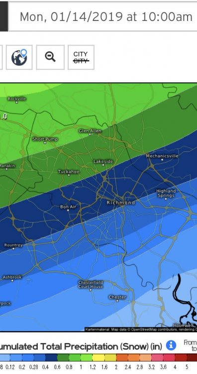
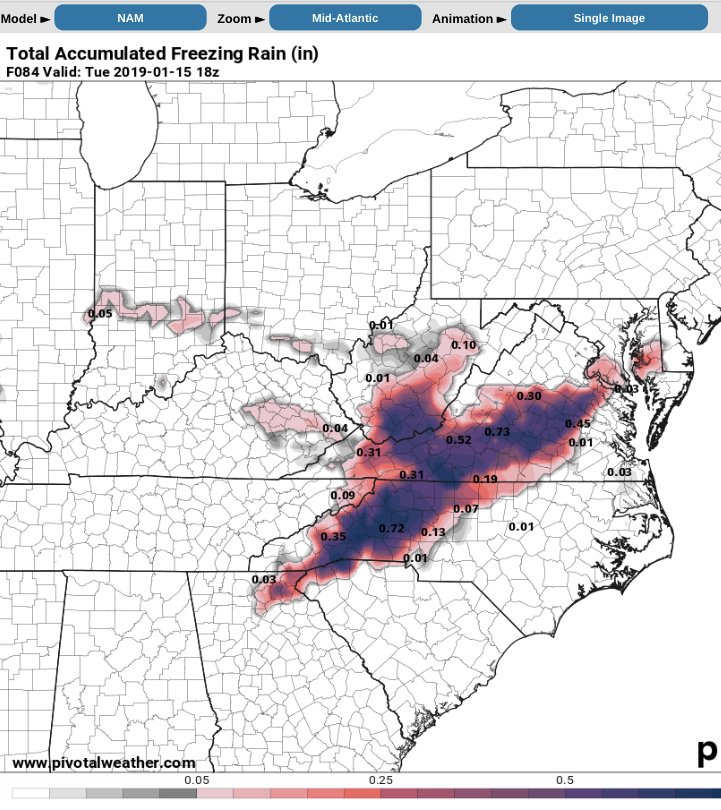
So I don’t understand how Glen Allen can show 1” of total frozen (liquid equivalent) and be 3” of snow. Must be sleet then right?? Anyone? Lol For 12z Euro
-
Just now, eaglesin2011 said:
 Still think this is a little low for a few places in the area.. but we will see if they update it later today..image 2 of 39previousnextclose
Based on that precip as snow I just posted, Glen Allen going to see mainly sleet? That’s 12z. What’s Kuchera in Glen Allen snowfall on latest Euro
-
Just now, Freshies said:
Only panel showing ice...

Interesting. Gonna be a lot of sleet then especially NW of 95 in RVA.
-
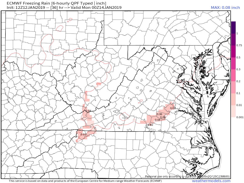
Ice accumulation Euro?
-
2 minutes ago, Ralph Wiggum said:
I'm sure Dr No will set us straight.
Not to sound cliché but nowcasting time cept for short term models no?
-
 1
1
-
-
2 minutes ago, Freshies said:
Trust me...I know! I have been lurking on these boards since Eastern (under a different screen name). I recently created a new profile because my name was DC centric and I didn’t want to be judged here in RVA lol. We need to post more in this thread...using the main thread for RVA specific progs is no bueno.
Yep. Folks here have been helpful
-
16 minutes ago, eaglesin2011 said:
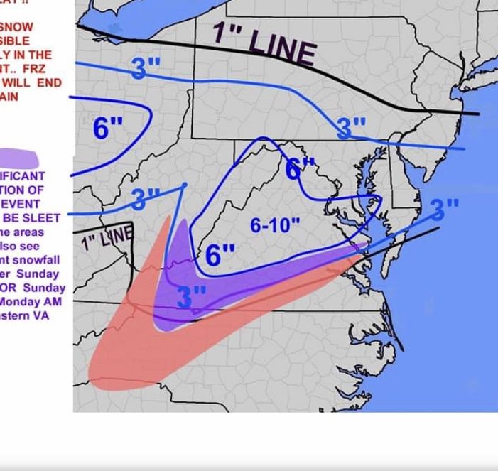
Def a better solution then frz/rain . Def still think a ice storm is a good bet around parts of this area tho.. hopefully to many people won't be caught of guard but still haven't seen the networks talking about it much yet
Possible to see some snow then freezing rain then back to snow especially nw areas of 95. Ugh for frz rain. But yes east end may be ok.
-
5 minutes ago, Freshies said:
Agreed! That NAM ice prog is showing ice for areas like Goochland that were looking at 4-8! Hoping for a crusty inch and expecting less here in the city. At least this will shut up the DC weenies...didn’t realize how awful they are until I didn’t live there anymore lol
Don’t worry about them. They are to us SOME OF THEM, like some new Englanders are to them. Lol. We had 13-15” before calendar winter began on 12/9 lol. DC not so much.

-
10 minutes ago, NovaTarHeel said:
Wow, I hope that's wrong. .5 of ice would cause a TON of power outages.
11 minutes ago, mikeeng92 said:
Thanks. Not good
-
1 minute ago, eaglesin2011 said:
Just Rain doubtful .. ice looking more and more likely
Stinks. Preparing for power outages. If anyone has good ice accumulation products let me no plz. From the models I mean. And no power during Eagles game!!! Noooooooo! Lol
-
1 minute ago, Inudaw said:
Might be more rain than we initially thought. NOt as much snow, ice favored, then goes to rain?
I think an ice storm is very possible. Anyone have the ice numbers from latest NAM? Cuz 10:1 latest NAM is high but it ain’t snow!
-
Just now, NovaTarHeel said:
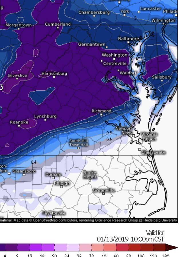
The Kuchera map is not good for RVA. It would be a complete ice storm.
That was my concern completely when I saw the NAM precip! Ugh. Anyone have a good ice acumulation map? Or can point me to a product?
-
I
1 minute ago, NovaTarHeel said:HECS in the DMV and a sleet/cold rain in RVA.
The atmosphere must have developed dementia. Where’s its memory?
Not a cold rain in RVA. Maybe south. Freezing rain is a concern though. Need Kuchera NAM map.
-
1 minute ago, Chris78 said:
Mid Atlantic special.

Kuchera poss?
-
8 minutes ago, JakkelWx said:
NAM doing NAM things.
Well FWIW up there the NAM did NAM things on 12/9/18 down here in RVA. And nailed it!
-
Just now, WhiteoutWX said:
There is a lot of warm air advection at mid levels. There's no closed 850 mb low to keep temperatures colder; the precipitation is basically one prolonged warm air advection event until Sunday afternoon when 850 mb winds turn northerly. This seems like a case where models would be more likely to under-do this warm air than over-do. I'd be hedging lower on the snow totals, higher on the ice/sleet.
So I guess you’re not a big fan of the DT first call?
-
3 minutes ago, dswx said:
Oh I am definite. " All I’m suggesting is that it may be time to realign geographiry to fit in better with the WAA issues AKQ deals with." Those were not what your words suggested at all. You said "LWX is consistently better". What part of the current Winter Storm Watch issued for Lousia, Goochland, etc. at 3:28 pm today is too complicated to comprehend with the event more than 24 hours away? And btw, perhaps LWX might want to realign their geography to fit in better with what AKQ deals with. The idea that LWX is consistently better is nothing but trash.
I'm out of here precisely due to this sort of uninformed, cheap shot NWS office bashing since it is not the first time. That is not the same as discussing the synoptic pattern or models. And I speak as a professional (non-NWS) met. So long.
I have no issue with what they’re doing so far with this storm AKQ. I don’t know the reason but December 9th was botched. There was lots of good guidance showing double digit snowfall totals, inside of 48 hours. Never pulled the trigger. Thankfully it was on a Sunday. On a workday it would have been a disaster on the roadways, with unprepared motorists.
-
3 minutes ago, wxtogo said:
Can someone knock on the door of AKQ and wake them up?
What are you referring to? There are watches up.
-
1
-
-
Just now, eaglesin2011 said:
I still think we get a good front & end or back end thump that will give us most of the accumulating snow... Just hope it dosn't all get washed away and or turn into freezing rain for hours...I rather have hours of sleet.. Will be no fun to look at but at least it wouldn't do as much damage.
There is a huge difference between sleet and an all out ice storm. Does anyone have any good ice accumulation model information? Trying to pass these concerns over to work leaders.
-
2 minutes ago, eaglesin2011 said:
most likely a sleet fest for hours in the metro.. but a few miles away could be big snow...snow/mix line big differnce
Yeah interesting. I live near you I think. Montpellier exit off of 295, staples mill rd
-
1 minute ago, Inudaw said:
Most guidance has increased the ice threat, and decreased the threat of higher snow totals for the Richmond area. Especially eastern areas. :p
So this “snow depth” on the 12z 1/11 euro could also include ice?


Richmond Metro/Hampton Roads Discussion
in Mid Atlantic
Posted
18z Euro says DEFINITELY not lacking QPF