

beavis1729
-
Posts
2,425 -
Joined
-
Last visited
Content Type
Profiles
Blogs
Forums
American Weather
Media Demo
Store
Gallery
Everything posted by beavis1729
-
Winter 2018-19 Medium/Long Range Discussion
beavis1729 replied to snowlover2's topic in Lakes/Ohio Valley
Well, the arctic outbreak disappeared on the 12z FV3. You just gotta laugh. Sure, it was 11-14 days out, but it was also showing up strongly on EPS ensembles over the past few days. It looks like the PV doesn't come as far south as modeled before...and it also goes more into New England instead of the Midwest. I guess it may come back...but, in the meantime, what happened?? -
Did someone steal your keyboard?
-
Good points. I wonder if a decent # of the 12z Euro ensemble members had positive developments in this regard, given that the ensemble mean was a bit NW of the op.
-
Fall/Winter 2018-19 Complaint/Banter Thread
beavis1729 replied to IWXwx's topic in Lakes/Ohio Valley
Definitely some amazing numbers showing up over the past few days of model runs. Would like to get this within 10 days before getting too excited, instead of the current 12-14 days. Assuming things continue trending this way, I would be ecstatic with a -20 at ORD. I don’t believe this has happened since January 1994. February 1996 and January 2009 came close...and many other nearby areas including RFD did hit -20 during those outbreaks. And, of course, the arctic tundra day of 1/6/2014. -14 at noon local time with wind chills in the -40s and a deep snowpack, but the winds never died down and the skies never cleared...so we only bottomed at -17 IMBY. At least there are 2 things that are favorable, as it looks now: expected snow cover in N IL and significant cold in southern Canada. Would like to see some snowcover in WI to reduce any possible modification of the airmass, and need to get this within 10 days on most/all of the models. Once that happens, a thread will be coming. Thoughts? -
Winter 2018-19 Medium/Long Range Discussion
beavis1729 replied to snowlover2's topic in Lakes/Ohio Valley
FWIW...over the past few days, HM has been harping on a pattern that could be conducive to a Midwest blizzard around this timeframe. Still way out there, but will be curious to see his thoughts. -
Winter 2018-19 Medium/Long Range Discussion
beavis1729 replied to snowlover2's topic in Lakes/Ohio Valley
Wow, amazing modeled cold. Hard to comprehend. Someone posted the EPS in the mid Atlantic forum...at day 15, departures of -15C to -20C were centered over our area. And good to hear about the weeklies. -
January 2019 Medium/Long Range Pattern Discussion
beavis1729 replied to John1122's topic in Tennessee Valley
Yeah...FWIW, the incredible 462 dm thickness contour made an appearance at hour 306. It's very rare to see even 474 dm...and 468 dm is almost unheard of. 462 dm almost seems impossible. Sure, it's Day 13 on one run of an operational model...but this is noteworthy simply because, over the past 25 years of winter observing, I have never seen 462. Good times...and nice discussion in here too! -
Winter 2018-19 Medium/Long Range Discussion
beavis1729 replied to snowlover2's topic in Lakes/Ohio Valley
Yeah, definitely...and then the 18z FV3 outdoes it somehow, at least for the upper midwest. There is a 462 dm thickness contour in southern Canada at hours 306 and 318. To put this in perspective: you very rarely see 474 thicknesses...and I may have seen a 468 once in the past 10-15 years...but I can't ever remember seeing 462. This is shocking cold...even for a model prog 13 days out. Here is another image for the archives. -56 in Ontario and -49 just north of the MN arrowhead.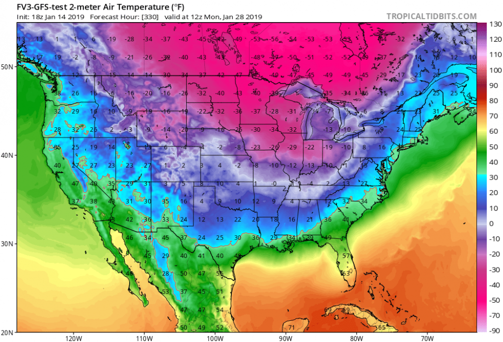
-
Winter 2018-19 Medium/Long Range Discussion
beavis1729 replied to snowlover2's topic in Lakes/Ohio Valley
FWIW, the 12z FV3 is going crazy again with an arctic outbreak toward the end of January. Besides the fact that it's 12-16 days out, and has been pushed back in time a bit relative to a few days ago...there is tremendous cold sitting in southern Canada that could be tapped eventually. Ideally, we would need a strong storm tracking NNE through the GL/OV and/or a potent clipper to drag down the cold air. Hopefully it will happen at some point. Even if the PV does come down for a visit, even I would be forced to admit that the temps shown on the FV3 are overdone. For posterity: -
Agree. And, you just get the feeling that the intense cold/PV in southern Canada is waiting to be tapped at some point. Just need a clipper and/or major storm to drag it down. Obviously it's very far out there and hasn't really moved up in time...but, verbatim, thicknesses on the 12z FV3 are sub-500 for much of the western Great Lakes for the entire Day 12-16 period.
-
Nice picture! Amazing what clear skies, calm wind, and limited UHI can do. It only dropped to 25F this morning here in the NW suburbs of Chicago, with a blanket of clouds and about 3" of snow cover.
-
Winter 2018-19 Medium/Long Range Discussion
beavis1729 replied to snowlover2's topic in Lakes/Ohio Valley
Wow, that’s a classic phase, pulling down the PV. Obviously a solution like that is unlikely, but the chances of it happening are greater than normal due to extreme cold lurking in S Canada and an amplified pattern. -
Winter 2018-19 Medium/Long Range Discussion
beavis1729 replied to snowlover2's topic in Lakes/Ohio Valley
It would be nice to have at least a little bit of snow cover everywhere within the sub-forum and upstream of us by January 20th. 2", 4", 12", whatever. There are some signs (although never guaranteed, of course) that the PV is going to come crashing down at some point, so it would be great to maximize the cold potential. -
January 2019 General Discussion & Observations
beavis1729 replied to Rtd208's topic in New York City Metro
Probably means -50 at surface...colder than 850mb temps due to snow cover/clear skies/inversion? -
Unfortunately for MBY, I agree. Dewpoint at ORD is only 7F...probably the driest air so far in this joke of a "season". Will take awhile to moisten up, especially with relatively dry NE winds ahead of the storm's arrival.
-
Fall/Winter 2018-19 Complaint/Banter Thread
beavis1729 replied to IWXwx's topic in Lakes/Ohio Valley
Nuiqsut, AK (north central part of the state) was -42 at 8 PM last night, south wind at 9 mph, wind chill -67. At least someone in North America is experiencing winter. -
January 2019 Medium/Long Range Pattern Discussion
beavis1729 replied to John1122's topic in Tennessee Valley
Nice discussion in here, all. Ironically, I just mentioned January 1985 in the Lakes/OV banter thread. Obviously grasping at straws...but does anyone think that an outcome similar to 1984-85 is remotely possible? That winter had an unacceptably warm December in the Midwest, but then things snapped around the new year. As an example: Chicago (ORD) only had 3.4" of snow for the season through December 30th, with a max seasonal snow depth of 1"...along with a ridiculous high/low temp of 69F/49F on 12/28/1984. Then, from December 31st through February 14th, about 35" of snow fell...and the temp dropped to -27F on 1/20/1985...still the all-time record low at ORD. From February 1st-9th, each day had a low temp of 3F or colder. This 45-day period was about 8 degrees below normal, with snow cover the entire time...maxing at 15" depth on February 14th. Then, winter ended abruptly after that. Interesting... -
Fall/Winter 2018-19 Complaint/Banter Thread
beavis1729 replied to IWXwx's topic in Lakes/Ohio Valley
Obviously grasping at straws here...but does anyone think that an outcome similar to 1984-85 is remotely possible? That winter had an unacceptably warm December in the Midwest, but then things snapped around the new year. As an example: ORD only had 3.4" of snow for the season through December 30th, with a max snow depth of 1"...along with a ridiculous high/low temp of 69F/49F on 12/28/1984. Then, from December 31st through February 14th, about 35" of snow fell...and the temp dropped to -27F on 1/20/1985...still the all-time record low at ORD. From February 1st-9th, each day had a low temp of 3F or colder. This 45-day period was about 8 degrees below normal, with snow cover the entire time...maxing at 15" depth on February 14th. Then, winter ended abruptly after that. -
And the Great Lakes/OV forum. Chicago has seen about 1-2” of total snowfall over the past 5 weeks, which will probably become 7 weeks...and parts of WI have seen less than 3” all season. Sure, the pattern may change soon...but even if it does, it won’t save the winter...even it results in something like 3x climo snowfall from 1/15 to 2/28. Winter is supposed to be a mood, a season, a vibe...not just “event driven”. A 2-week wintry period (assuming this even happens) is not winter. The season is 13 weeks, not 2 weeks. That is what’s driving people crazy. Where are the clippers? Windy arctic fronts? Anything resembling the feeling of winter? Where are the seasons in seasons? Weenies across the country are upset...no one is spared. Of course you hold out hope for a dramatic flip...like in Chicago when it hit 69F on 12/29/84 and then -27F 3 weeks later on 1/20/85. But you can’t pin your hopes on that.
-
Fall/Winter 2018-19 Complaint/Banter Thread
beavis1729 replied to IWXwx's topic in Lakes/Ohio Valley
-
Fall/Winter 2018-19 Complaint/Banter Thread
beavis1729 replied to IWXwx's topic in Lakes/Ohio Valley
Yep. Unfortunately, I agree with you. -
Fall/Winter 2018-19 Complaint/Banter Thread
beavis1729 replied to IWXwx's topic in Lakes/Ohio Valley
Probably not. Americans tend to be a “me first” and “country first” culture, with very little emphasis put on world affairs. I hope the conversion will happen someday, but I am not too optimistic. -
Fall/Winter 2018-19 Complaint/Banter Thread
beavis1729 replied to IWXwx's topic in Lakes/Ohio Valley
Unfortunately this F/C issue is a common mistake when non-scientists report on news. It should say “16 Celsius degrees above normal”...which is equivalent to about 29 Fahrenheit degrees above normal. For every 5 C change, it’s a 9 F change. -
Fall/Winter 2018-19 Complaint/Banter Thread
beavis1729 replied to IWXwx's topic in Lakes/Ohio Valley
-
Winter 2018-19 Medium/Long Range Discussion
beavis1729 replied to snowlover2's topic in Lakes/Ohio Valley


