-
Posts
4,732 -
Joined
-
Last visited
Content Type
Profiles
Blogs
Forums
American Weather
Media Demo
Store
Gallery
Everything posted by Windspeed
-
Tropical Storm Mindy Max Winds 45Mph
Windspeed replied to SnowenOutThere's topic in Tropical Headquarters
The small low-level vorticity maximum that developed is what got this going. Given another day or two, yadda yadda, would have probably been a hurricane. -

Tropical Storm Mindy Max Winds 45Mph
Windspeed replied to SnowenOutThere's topic in Tropical Headquarters
Just edit your original post for the thread and change the title. -

Tropical Storm Mindy Max Winds 45Mph
Windspeed replied to SnowenOutThere's topic in Tropical Headquarters
@SnowenOutThere If you start a tropical thread, you own it and keep it updated. [emoji16] -

Tropical Storm Mindy Max Winds 45Mph
Windspeed replied to SnowenOutThere's topic in Tropical Headquarters
-

Tropical Storm Mindy Max Winds 45Mph
Windspeed replied to SnowenOutThere's topic in Tropical Headquarters
-

Tropical Storm Mindy Max Winds 45Mph
Windspeed replied to SnowenOutThere's topic in Tropical Headquarters
Looks like TS Mindy. https://www.nhc.noaa.gov/text/refresh/MIATCPAT3+shtml/DDHHMM.shtml -

Tropical Storm Mindy Max Winds 45Mph
Windspeed replied to SnowenOutThere's topic in Tropical Headquarters
-
Is not the NYC Post a mongering tabloid? *looks at the owning company* lol, yeah...
-
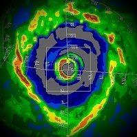
Just satellite estimates. Unsure if the Japan-based recon project from several years ago is still a thing. ADT unfortunately isn't the best with small 'canes/typhoons that have pinehole eyes. Hence 945 mb / 115 kts at present via latest estimates. JTWC notes this issue in its prognostic reasoning:
-

Tropical Storm Mindy Max Winds 45Mph
Windspeed replied to SnowenOutThere's topic in Tropical Headquarters
A little overzealous over night at a TS being "likely" in my post but there does appear to be broad low-level circulation with banding developing on the southeast side. There's assymetry and subtropical characteristics. Recon is not scheduled. NHC gives a medium chance of genesis. It's not got a lot of time prior to the panhandle but could gain enough organization to get classified. -

Tropical Storm Mindy Max Winds 45Mph
Windspeed replied to SnowenOutThere's topic in Tropical Headquarters
Looks like a low-level circulation is forming tonight. Quite evident on shortwave too. Good call on the thread. A tropical storm by landfall is looking likely now. -
Larry's structure has improved some this evening thanks to some convective bursting rotating around the eyewall. Larry's forward motion appears to finally be increasing as well. It's possible that Larry's core may have gained enough forward motion to counter the rate of significant upwelling. Not expecting anything impressive as far as reintensification tomorrow, but that is usually when surprises occur [in my case]. If nothing else, perhaps it might restrengthen enough to avoid losing major hurricane status the next few days. It is barely a Cat 3, and though 850 hPa winds are still between 100-110 kts, the SFMR data was perhaps only supportive of 90 kts. Could have been undersampling, but, at any rate, Larry appears to be holding its own if not rebounding a bit tonight. This remains an enormous hurricane in size and wind field, which should act as a deterrent to significant strengthening.
-
Well so much for the Atlantic Basin (Larry) overcoming the Western Pacific's ACE. Chanthu is about to become violent and will likely evolve into one of 2021's most intense long-tracking tropical cyclones. The rate of organization is outpacing forecast trends and it looks like this has a good shot at becoming a Super Typhoon. It will have a very favorable environment for rapid intensification.
-
-
Normally they are stable and less susceptible to them, however, Larry has a big issue here with upwelling due to its slow rate of motion. The circulation is already enormous and strong outer banding is moving over better heat content in the northwest seas leading out ahead of Larry's core. That's leading to two things here. 1) Less thermodynamic support for eyewall convection by the time it reaches those waters and 2), subsidence, which is helping to erode the eyewall leading to it being unstable. If Larry would pick up forwarding motion that would help alleviate its problems. But that's not going to occur in the short-term. There is still very warm SSTs east of Bermuda on its track. But the NHC has dropped down the intensity guidance.
-
Larry's forward motion appears to be slowing. I suppose we're going to find out just how much shallow TCHP can support a 'cane this large. Another EWRC is underway. But Larry is not in any hurry to the NW on its current heading at the moment. Granted there is still plenty of deeper OHC to the northwest. Really at this point it's just a visual experiment on if Larry can maintain enough thermodynamic driven convection to fuel the even larger eyewall that is forming. There is a rather large region of 29°C SSTs northwest on its current heading. Should be enough to keep it a major hurricane through Thursday.
-
Larry is pumping up the Atlantic's ACE. Based on its forecast alone, it should allow the Atlantic to overtake the EPAC and WPAC barring any potential development in those basins this week.
-
Dropsonde recorded 957 mb at 9 kts. 102 kt SFMR in the northern eyewall. Likely a bit stronger in the NE eyewall based on relative motion. So the satellite intensity estimates are performing well as is the NHC's best track intensity guidance.
-

2021 Atlantic Hurricane season
Windspeed replied to StormchaserChuck!'s topic in Tropical Headquarters
A convergent boundary has setup in place north of the Yucatán that is associated with 91L's northern axis. Low level flow is southerly but with an absence of any notable cyclonic rotation. However, if this boundary can persist with strong convection and increase the gradient, an MCS may develop, which could increase potential of development as the feature drifts north into the central GOM. Shear appears too strong over the BOC for anything to get going for the original low pressure. If something is to organize, it's going to be out of that region of strong low level convergence. -
Larry has a huge circulation. But its new massive eyewall might be moving just fast enough with respect to oceanic heat content to do something special over night, perhaps not seen in the Atlantic since Isabel: A giant annular intensifying major hurricane. Category four intensity seems in reach as the presentation continues to improve. Could it make a run at Isabel's lofty status as the most powerful annular 'cane? If it can maintain forward motion enough to avoid its own upwelling we could definitely see some significant intensification here. But Isabel is the rarest of the rare, so probably no...
-
Larry appears to be going through another EWRC. It looks like the inner eyewall, which isn't exactly small, is not convectively bursting as much and may be breaking down. The new eye may end up being quite large.
-

2021 Atlantic Hurricane season
Windspeed replied to StormchaserChuck!'s topic in Tropical Headquarters
Agree. Doesn't matter if the WATL is suppressed if you already had genesis in the MDR from the convectively active phase over the WAM. Just means it's less likely to be homegrown genesis. -
Well now quasi-annular is a thing. Probably should have had an official designated title when 'canes are showing annular characteristics but are not fully annular. Kind of like quasi-linear super cells. Linear cells that have super cell characteristics.
-
Guidance is allowing greater confident this remains east of Bermuda and keeps them out of the core. The remaining threats would be large swells for the ECONUS seaboard and problems for maritime shipping interests. But direct landfall is becoming unlikely, which is good news. Hopefully no wild swings back west until the track is locked in..
-
The sudden warming interval began around 14,700 years ago. The cold reversal didn't occur until around 12,800 years ago. That's almost 2000 years of warming that led into the potential salinity driven cold spike. But it was rapid back to cold, yes. But even at that, the rapid cold swing can be explained by several hypothesized natural phenomenon. Where as right now at present, the warm spike in ~200 years is pretty astonishing.


