

Windspeed
-
Posts
4,850 -
Joined
-
Last visited
Content Type
Profiles
Blogs
Forums
American Weather
Media Demo
Store
Gallery
Everything posted by Windspeed
-
2024 Atlantic Hurricane Season
Windspeed replied to Stormchaserchuck1's topic in Tropical Headquarters
Irma was indeed a classic long-tracking CV hurricane, but even by comparison to the historical record, it took precedence. After TCG occurred 120 n mi WSW of São Vicente in the Cabo Verde Islands, it only took 48 hrs to become a major hurricane. But even with respect to its initial RI, perhaps what stands out most is its track. Irma gained a decent amount of lattitude due to a modest weakness in the eastward extension of the Bermuda-Azores SPH. The hurricane also weakened due to some interaction with SAL and cooler SSTs, undergoing some internal restructuring. However, Irma turned back WSW during its four-day trek across the MDR. Irma's position timed perfectly and, unfortunately, with respect to the Leewards, with restrengthening of the ridge and east-north-easterly flow of the 700-500 hPa steering layer. Above normal SSTs across the central and western MDR combined with exceedingly stacked/aligned atmospheric flow from the surface to 300 hPa level and favorable ULAC aloft enabled Irma to become, at that time, the most intense CV hurricane on record (surpassing Isabel) at 914 mb prior to slamming Barbuda and St. Martin. Beyond the more technical meteorological discussion, in general, when you have a CV hurricane losing latitude on its westward track through the MDR, it is bad news. Note: Irma first reached 20N at 40W. After its turn WSW, it didn't reach that lattitude again until 66W, north of Puerto Rico. -
2024 Atlantic Hurricane Season
Windspeed replied to Stormchaserchuck1's topic in Tropical Headquarters
The Caribbean Low-level Jet (CLLJ) is usually why the Caribbean, from east to west, is a graveyard in June and July. Especially if there is a TUTT in place over top. The CLLJ tends to relax by mid-to-late August, if not earlier, as the SPH cells gain a bit of latitude. Generally, the westward extension of the Azores-Bermuda high propagate east and west across the basin in a tug of war with exiting CONUS trough and jetstream interaction. But this year, with a +AMO in place and cool neutral ENSO, we may see the Bermuda cell linger into the ECONUS coastal region, even if the eastward Azores extension waxes and wanes with digging central Atlantic troughs. -
Ongoing electrical infrastructure woes...
-
Summer-Fall 2024 Weather Disco Med/Long Range
Windspeed replied to John1122's topic in Tennessee Valley
Latest ECMWF rainfall anomaly for ASO from Ben Noll's site. Interior CONUS is dry except for portions of the Midwest and Ohio Valley and very suggestive of cool neutral ENSO / La Niña pattern. Note the very active Atlantic and long-track setup for TCs. Potential drought conditons during the period for the Tennessee Valley without much progressive frontal precipitation. Hopefully, some weaker systems will bend around the ridge a curb drought conditions. Unfortunately, some of those systems will likely be hurricane strikes for the SE CONUS.- 688 replies
-
- 4
-

-

-
- heat
- thunderstorms
- (and 7 more)
-
2024 Atlantic Hurricane Season
Windspeed replied to Stormchaserchuck1's topic in Tropical Headquarters
The latest rainfall anomaly by the ECMWF for ASO from Ben Noll's site. You'd not expect to see a more ominous pattern / setup for TCs being driven west. Ridging is in place, so frontal / trough induced precipitation in the CONUS interior is below normal. This not only smells of a cool neutral ENSO / La Niña, but also suggests long-tracking TCs with late recurves. -
2024 Atlantic Hurricane Season
Windspeed replied to Stormchaserchuck1's topic in Tropical Headquarters
Their forecast of 140 ACE west of 60° longitude is pretty much a dead giveaway that you'd expect an ugly season for the Caribbean and SE CONUS. The pattern screams either central American landfalls or late recurves during ASO. We have potential drought conditions developing in the inter-SE region for August and September. Bermuda ridging and westward extension of the Azores SPH is already having its way. The relief may only come from landfalling TCs. You'd hope that all of them would just be weaker systems for beneficial rain. But you'd expect some of those would unfortunately be hurricane strikes. I agree that Beryl is likely a harbinger of things to come. -
Summer-Fall 2024 Weather Disco Med/Long Range
Windspeed replied to John1122's topic in Tennessee Valley
RE: Rain from Beryl... A line of storms tries to advance eastward into Wednesday, but unfortunately, moisture feed and the advancing southerly flow just dwindles and dies. It's not looking all that promising, but perhaps the NE TN Valley can get some isolated development. -
Great Scott!!!
-
2024 Atlantic Hurricane Season
Windspeed replied to Stormchaserchuck1's topic in Tropical Headquarters
Azores ridge block-induced SPH cells should be cranking easterly low-mid level trades. ITCZ should be under a suppressive regime until late July/ early August. Not complaining; in need of a reset. SSTs will still be predominantly at mean or above normal in time for ASO. Even within a hyperactive season, there is a relatively confined period of lull. 2005 was pretty much dead between Emily and Katrina aside from some weaker central Atlantic TCs that got named and a weak BoC system into Mexico. Edit: In hindsight, the 2005 lull was not exactly dead, and Franklin reached 60 kts in its brief cycle, but we didn't see much in the way of any substantial ACE producers. This isn't to say we won't have another significant TC between now and mid-August. But it's important to note that the last few hyperactive seasons didn't get started until their climatological norm. Edit 2: I feel like I am correcting myself too much, but 2020 did feature a landfalling hurricane into, big surprise here, Texas! That was Hanna on July 26th. This was a GOM system that had an easterly wave as its source. However, it was more in line with climatological norms. So, to be specific, I want to state the MDR may remain in a lull until mid-August as that was the overall point of my mind when I typed above. It's been a long day. -
2024 Atlantic Hurricane Season
Windspeed replied to Stormchaserchuck1's topic in Tropical Headquarters
In short, yes. An intraseasonal period is modeled out beyond a few weeks with some westerly wave breaking and SAL plumes. Perhaps in a few weeks, there is something homegrown/SW Caribbean. -
Multi-model ensemble tracks for the 95L/Beryl from onset to final landfall. https://x.com/burgwx/status/1810425710223483086?t=ZBTiQmbgg0oO73E-KiNHvw&s=19
-
Beryl may end up being the most expensive Cat 1 landfall just from wind damage. Katrina was pretty high due to Miami. It's never good when you have an eyewall cross over a densely populated metropolitan and residential area, not even a Cat 1.
-
As has been repeated, an intensifying eyewall and associated bands with strong convection mix down more efficiently versus an eyewall that is falling apart with gusts that are merely gradient driven. I am not surprised by all the 80+ mph gust reports. There are plenty of examples of rapidly weakening category 3 hurricanes that had very spotty or limited 90-115 mph gusts. Though we have limited data currently, this same hurricane may have been exactly such an example on its landfall in the Yucatán. Most reports were unimpressive versus the reports out of Jamaica. There is no need to bring up Carriacou, Union, and the Grenadines, which were devastated. 100% certain Beryl will be retired.
-
Beryl appears to gradually be increasing forward motion. Must be feeling the trough. Flooding is occurring, but hopefully, Beryl can lift out by this afternoon, and the metro can avoid any trailing feeders off the GOM.
-
Landfall. Discussion....
-
Josh has 982 mb and dead calm, near the center of the eye. Official landfall is imminent. Edit: 981 now.
-
Where are you approximately? Edit: Nevermind, I see you're in Bay City.
-
Western eyewall as well. Surge must be coming off the lagoon / Matagorda Bay.
-
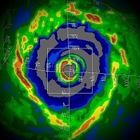
Subsidence helps to clear out an eye feature, but if you analyze the current structure of the core, you'll see the broad structure remains. Note the area of 50 kt + 2-km winds away in the NE quadrant. Shallow convection is too slow in process to force the contraction of the vortex and RMWs in the small window of time. We need to see explosive deep convection ASAP to drive rapid pressure falls and create a sink for contraction. (Image Source: Lidar from the LROSE project @ CSU)
-
We would need to see persistent intense CBs in the core, and that just hasn't occurred yet. Beryl is gradually improving but still lacks a well-formed eyewall. Good news so far to mitigate wind and surge. We're within the 12-hour window from landfall. Unless there is a rapid change in core convection, a Cat 2 is looking less likely.
-
Beryl's broad RMW and the lingering effects of stable airmass thanks to interaction with the ULL are all very critical and fortunate caveats to the evolving pristine upper environment and thermal support. Very little doubt in my mind that Beryl would have been a category 3 or 4 given a much earlier headstart of recovery off the Yucatán. Still, 18 hours is enough time for Beryl to rein in the vortex if it can build an eyewall by this afternoon and mix out what's left of the stable airmass. A category 2 landfall is still very reasonable.
-
Good discussion by Beven. When recon arrives, it will be interesting to see if the surface circulation is getting tugged any underneath the new MLC and if the intense CBs on the western periphery continue to be due to the onset of an eyewall. I will say that these convective bursts are not waning this evening. If anything, it's growing in coverage. But structure is an unknown until recon gets there with Beryl not being in range of radar.
-
Hypothetically, Beryl needs a strong eyewall already evolved and nearly constant CBs by at least tomorrow evening if we're presented with enough time to reach Category 3. The pressure needs to be in a nosedive and rein in that RMW to allow rapid intensification to occur. But something like Harvey? That is going to take extreme pressure drops in a 24-hour period to overcome Beryl's current structure. Harvey bottomed out at 937 mb at landfall. I have been shocked plenty of times during my obsession with this discipline, and this would no doubt be right up there near the most. Beryl may find itself under a pristine ULAC with northerly jetstreak enhancement, but there will still be a trade-off between intermittent gulps of dry air that may occur. I think a Category 2 is a safe forecast. A three should be the ceiling. But hell, there is always the absurd when it comes to 30°C SSTs to fuel it. We'll see what Beryl's structure is like in 12 hours.
-
I really don't understand why Ryan posted that image, especially without any context. It's two completely different scenarios, and it just misleads. I am astounded sometimes at professional mets. I realize they're human and susceptible to excitement and hype. The adrenaline gets to me sometimes as well. But there is a limit. This is not Harvey 2.0.... Good on Webb there. It deserved a good thorough explanation of why this is not the same situation to curb any fears for pre and post landfall.
-
Yes, Beryl's problem with a partial core, despite deep convection aiding in regenerating an MLC, is that it's not yet shielded off from the stable airmass that still lingers within the southern half of the circulation. The ULL is still too close and feeding that stable air into the mid-levels. And any nascent core is very prone to downdrafts in this scenario. So even this convection and attempt at a new core could rapidly collapse. We'll just have to see if it's resilient. If anything, this kind of continued bursting will moisten and assist in future convection. Obviously, the modest environmental conditions will continue to improve and become more favorable.