-
Posts
4,733 -
Joined
-
Last visited
Content Type
Profiles
Blogs
Forums
American Weather
Media Demo
Store
Gallery
Everything posted by Windspeed
-
Roger Smith, who ran our seasonal forecast contests, passed away
Windspeed replied to GaWx's topic in Tropical Headquarters
Oh no!! He will be greatly missed! Thank you GaWx for letting everyone know. Rest in peace, Roger. May your contests be forever eternal in the great beyond. -

2026 Atlantic Hurricane Season
Windspeed replied to Stormchaserchuck1's topic in Tropical Headquarters
If El Niño is strong, which I do think it will be, it should, in theory, give the Atlantic a break this year. That doesn't mean we still won't see a few hurricanes or perhaps even a few landfalls. The old saying, it only takes one while recalling Andrew in '92, a strong Niño year, etc.; however, I would expect overall activity to be below normal for seasonal numbers. Too much shear and unfavorability across the basin should curb CV long-trackers. Obviously, if ENSO doesn't swing too positive or the Niño is weaker, then anything is on the table. As of now, based on current trends, I do expect below normal overall activity in 2026 for the Atlantic basin. -

Jan 30th-February 1st 2026 Arctic Blast/ULL Snow OBS Thread.
Windspeed replied to John1122's topic in Tennessee Valley
I think KTRI officially got down to -3°F at the airport, but my vehicle read -5°F at work in Bristol. Either way, an official new record low temperature for February 2nd. Fortunately, there's no wind, so there's no real difference in wind chill. -
We are either going to tie or break our record low for KTRI by daybreak. Skies are clear, and I am at 0°F at my location. Showing 1°F at KTRI. The official record low for KTRI on February 2nd is exactly 0°F. With a clear sky and no wind, surely we can drop another degree or two at the airport. Edit: And we officially recorded a new record low for February 2nd. Currently -1°F at KTRI. Edit 2: Posted in the storm OBS thread, but will paste here for posterity. KTRI officially got down to -3°F at the airport, but my vehicle read -5°F at work in Bristol. Either way, an official new record low temperature for February 2nd. Fortunately, there's no wind, so there's no real difference in wind chill.
-

Jan 30th-February 1st 2026 Arctic Blast/ULL Snow OBS Thread.
Windspeed replied to John1122's topic in Tennessee Valley
It's just too cold for brine to be effective at these temperatures, no? They heavily treated the main road nearby, and it's all white other what they've managed to scrap or plow. -

Jan 30th-February 1st 2026 Arctic Blast/ULL Snow OBS Thread.
Windspeed replied to John1122's topic in Tennessee Valley
Congrats to everyone who got smashed. The event is still going, of course. We still have nice backing bands. Might we get a deformation band or trowal as the precipitation pulls eastward this afternoon? -

Jan 30th-February 1st 2026 Arctic Blast/ULL Snow OBS Thread.
Windspeed replied to John1122's topic in Tennessee Valley
One bad aspect of the initial melting the first few hours this afternoon is that all that wetness is going to freeze solid under the snow tonight. Should be pretty slick for driving upon later even with the more powdery stuff to come on top of it. -

Jan 30th-February 1st 2026 Arctic Blast/ULL Snow OBS Thread.
Windspeed replied to John1122's topic in Tennessee Valley
Cranking heavy snow here just south of Bristol. Big fatties. Ground is white. Starting to cover driveway and road. -
The RGEM crushed our souls last week once it got into range. Everything quickly followed suit, so I'm going stubbornly stick with it through the evening. The 12z run doesn't have my location with an inch of accumulation at 10:1 until around 0z / 7PM. That seems reasonable, given the melting occurring with the sun. I figure we won't see heavy returns until sunset. As the temperature drops that ratio should also increase with the cold column in place.
- 782 replies
-
- 1
-

-
- extreme cold
- snow
-
(and 1 more)
Tagged with:
-
We're nearly in nowcast mode. Banding across Kentucky into SWVA is steadily thickening on returns out of Jackson. Some of this may no longer be virga. Also returns are beginning to fill out of Morristown. Game time is upon us.
- 782 replies
-
- 4
-

-
- extreme cold
- snow
-
(and 1 more)
Tagged with:
-
Latest RGEM...
- 782 replies
-
- 1
-

-
- extreme cold
- snow
-
(and 1 more)
Tagged with:
-
Text for the map above..
- 782 replies
-
- extreme cold
- snow
-
(and 1 more)
Tagged with:
-
I feel completely opposite versus last weekend's lead time into the event for a snow storm. Obviously, that transitioned into worry for the ice storm. But with respect to all snow, perhaps even significant totals, my confidence is growing. Got to love recent trends with a stronger and slower mid-to-upper low versus the coastal surface low. If the moisture feed is there, that ULL will eat. Very cold column and high ratios. I guess if I get my heart broken, so be it. I am all in on this system.
- 782 replies
-
- 3
-

-
- extreme cold
- snow
-
(and 1 more)
Tagged with:
-
Ripping fatties in Bristol. Best snow of the entire event. Interestingly, the precip is showing up as rain on radar. But it's all snow.
- 618 replies
-
- 3
-

-
- observations
- obs thread
-
(and 1 more)
Tagged with:
-
So it begins. I am hoping that downsloping off Holston Mountain will aid in some warming south of Bristol just enough to subdue the freezing rain at my house. But I am sitting at 28° right now. It's going to be a close call for a while. I think we can handle ~.25 without mass outages, but I'd not dare chance much more.
- 618 replies
-
- 4
-

-

-
- observations
- obs thread
-
(and 1 more)
Tagged with:
-
You hate to see it, Carver. We still hold some cards. But it's getting dangerously close to the event. I will say we've been very lucky the past three to four decades regarding heavy ice accumulations. I think it was even '77 or '78 the last time KTRI saw icing on a scale that could play out in this event. Hopefully, it does not.
-
Just want to thank everyone for their input and analysis the past few days. I am worried about the duration of the freezing rain event for KTRI. I am now just hoping all hope for significant downsloping to get surface temps above freezing. I have thrown in the towel for snow. Yes, we may still see 3 to 4 inches here. But it will not be fun if the ice accumulation occurs. The grid here can't handle anything over .5, God forbid .75, without greatly increasing the scale of damage to infrastructure. I am hopeful that a change over to heavy rain could result in significant melting before strong NW surface flow hits.
-
I want snow like everyone else here. But I am in total agreement with you on this. If the berserk modeling runs this morning verify, the severe cold that follows is going to be a huge concern. Major power outages with a slow recovery to repair lines. Hopefully, the models have hit their peak and are way overloaded. But unfortunately, anything around a foot of snow, followed by severe bitter cold will cripple infrastructure for the region. Often, we have a warmup after a major snow event. The timing of the upcoming event is not so great in this regard.
-

Major Hurricane Melissa - 892mb - 185mph Jamaica landfall
Windspeed replied to GaWx's topic in Tropical Headquarters
They transmit data several times a second until they splash down to get a real-time measurement of the column they're falling through. In this particular case, the peak of the gust occurred at 657 ft, but the gust most likely continued through decent into splash-down being that low. I haven't read the entire data transfer, however. That being said, there is no bearing on height. It could have occurred even closer to splash down, given the high frequency of the data transfer. 657 ft is pretty close to the surface, though. Within 20 seconds to splash down at 10m/s.. -

Major Hurricane Melissa - 892mb - 185mph Jamaica landfall
Windspeed replied to GaWx's topic in Tropical Headquarters
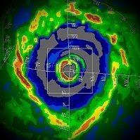
NSF NCAR researchers have confirmed that the record-breaking wind gust of 219 kts (252 mph) recorded in Melissa was accurate after completing their analysis. https://news.ucar.edu/133047/record-breaking-winds-confirmed-hurricane-melissa -

Major Hurricane Melissa - 892mb - 185mph Jamaica landfall
Windspeed replied to GaWx's topic in Tropical Headquarters
Unfortunately, that's what you would expect to see from a higher-end Category 5. The footage is still insane, however. Thanks for sharing. RE: Deaths, I would be shocked if the toll remains below 100. There is just too far wide an area of immense devestation, especially through the interior of the island, and it takes time to search with cadaver dogs through all scattered piles of debris. -

Major Hurricane Melissa - 892mb - 185mph Jamaica landfall
Windspeed replied to GaWx's topic in Tropical Headquarters
Flooding did occur. I just do not have access to anything official yet. Based on images, there was clearly a strong storm surge in the right-front quadrant. Also, the eastern areas of the island did not go unscathed as there was flash flooding off the ridges. But so far, I have not read any official numbers yet on either. Hopefully, as Melissa gained forward speed while crossing the island, mudflows due to flooding were mitigated somewhat. If anyone has anything official, please share. -

2025 Atlantic Hurricane Season
Windspeed replied to BarryStantonGBP's topic in Tropical Headquarters
https://tropical.atmos.colostate.edu/Realtime/ CSU TC-RAMS matches NOAA's.. The other site seems off as 34.7 is corrrect. -

Major Hurricane Melissa - 892mb - 185mph Jamaica landfall
Windspeed replied to GaWx's topic in Tropical Headquarters
Yeah, unfortunately, it seems everything operationally is verifying on the ground. I am hopeful many lives were saved by residents heeding the advanced warnings. They had several days to plan. It will still be a miracle if the death count doesn't rise, however, despite the more densely populated areas in eastern Jamaica avoiding the eyewall. As you can see in the imagery, there are an overwhelming number of structures deroofed, walls down, or completely destroyed. -

Major Hurricane Melissa - 892mb - 185mph Jamaica landfall
Windspeed replied to GaWx's topic in Tropical Headquarters
I expected the imagery to be sombering for the southern coast. But the amount of destruction on Jamaica's NW coast, Montego Bay, etc., is pretty horrible. Clearly, Melissa's eyewall remained intense all the way across the island.

