IWXwx
-
Posts
6,632 -
Joined
-
Last visited
Content Type
Profiles
Blogs
Forums
American Weather
Media Demo
Store
Gallery
Everything posted by IWXwx
-
.5" here also
-

Winter 2025-26 Medium/Long Range Discussion
IWXwx replied to michsnowfreak's topic in Lakes/Ohio Valley
Looks like an overperforming clipper to start the new year will be the best we can do for awhile. -
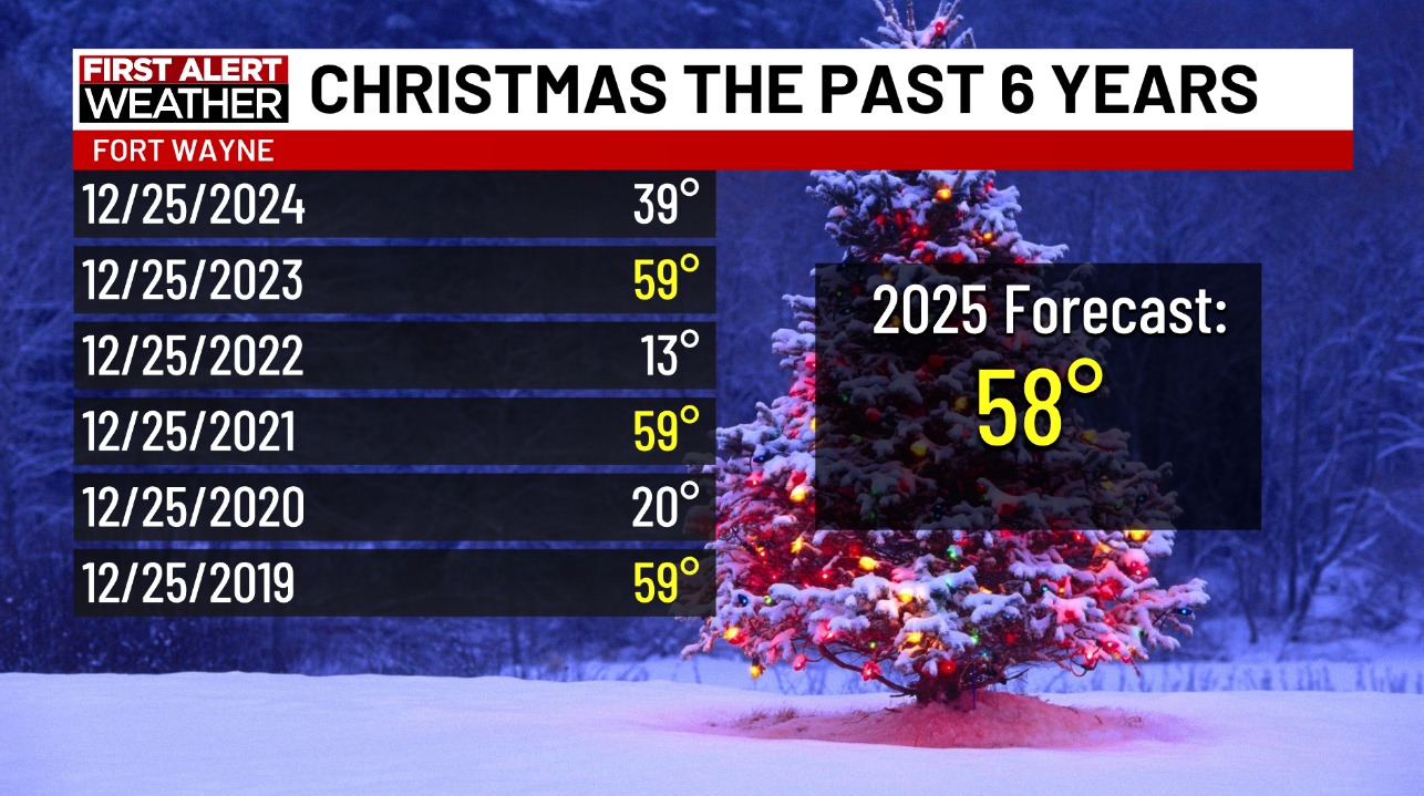
Matt Leach (WxMatt21 here) posted this on his Channel 21 Facebook a couple of days ago. It's quite an interesting pattern for Christmas temps in Fort Wayne. That 58 forecast has been dropped several degrees now as the warm front looks to get hung up father south than originally anticipated

-
Winter 2025-26 Medium/Long Range Discussion
IWXwx replied to michsnowfreak's topic in Lakes/Ohio Valley
Who was it in here that once had a snow making machine? There may have been two people. -
2.3" here is my call and 1.8" forward FWA. I'm just happy to see another daytime event. But the following bitter cold, and then quick torch, naso much.
-
Winter 2025-26 Medium/Long Range Discussion
IWXwx replied to michsnowfreak's topic in Lakes/Ohio Valley
Chasing tornadoes on Christmas would be a nice gift. -
Winter 2025-26 Medium/Long Range Discussion
IWXwx replied to michsnowfreak's topic in Lakes/Ohio Valley
moneyman -
Winter 2025-26 Medium/Long Range Discussion
IWXwx replied to michsnowfreak's topic in Lakes/Ohio Valley
You look to be in the best position of almost anybody in the forum to see some decent accumulations before it peters out. -
Picked 2.9” of fluff overnight, with 6.5” on the ground. That depth won’t last long though.
-
With ratios looking to be up to 20:1, my call is 4.5" here.
-
Nov 28-30th Post Turkey Day Winter Storm
IWXwx replied to Chicago Storm's topic in Lakes/Ohio Valley
I had a blast putting up Christmas lights all afternoon in SN and bursts of +SN. I measured 6.9" at 11 PM (EST), with light snow still falling, but must have had some mixing issues after midnight, causing some melting/compaction as there was only 5.5" at 7 AM CoCoRaHS measure. All in all, a good storm to track with nice results. On to another possible 2-4 tomorrow night! -
Nov 28-30th Post Turkey Day Winter Storm
IWXwx replied to Chicago Storm's topic in Lakes/Ohio Valley
I'm glad to hear that the Euro decided to play ball. I wasn't aware of that concerning the NBM.
-
Nov 28-30th Post Turkey Day Winter Storm
IWXwx replied to Chicago Storm's topic in Lakes/Ohio Valley
Crossing my fingers too. I saw your call and if it is onto something, you might have to bring your totals down a little, especially to the south and I would that for you (and me lol). But at least you have warned the public about possible last minute changes since we are riding the edge. So far IWX and you are in pretty good agreement though. -
Nov 28-30th Post Turkey Day Winter Storm
IWXwx replied to Chicago Storm's topic in Lakes/Ohio Valley
@Jackstraw Euro is doin' its thing to us.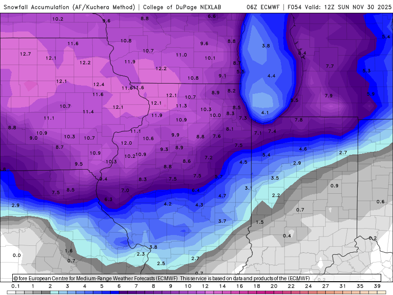
-
Did you read IWX this morning? Given the incredible thermodynamics, Lake Superior connection, and synoptic support any mesolow or dominant band will be capable of producing snowfall rates of up to 3"/hour with thundersnow quite possible. There is still some uncertainty where exactly the band sets up and how long it stays in one area (models show some variation to the flow through Monday), but snow will be measured in feet, not inches, for any location that sees this dominant band visit for more than a few hours. Have a conservative 6-12" for La Porte County right now but that could certainly go higher. Winds will also be a concern with this event.
-
Euro owned by the GFS
-
It's gonna take a lot more than 0.06" to break the FWA drought.
-
Thanks guys. I'm sure you're right. I know the soybeans are being harvested, but still quite a few corn fields around here that's still pretty green, but drying rapidly.
-
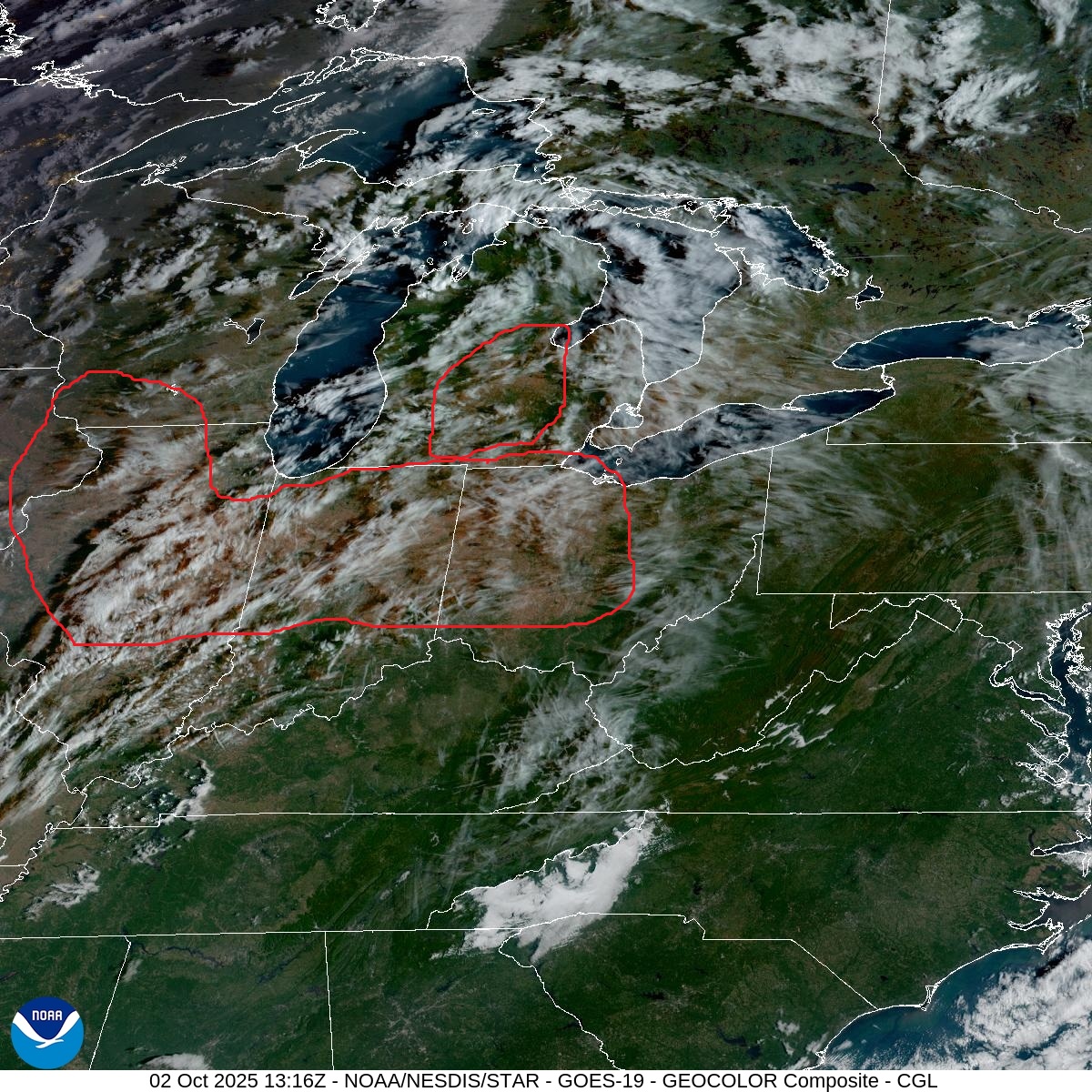
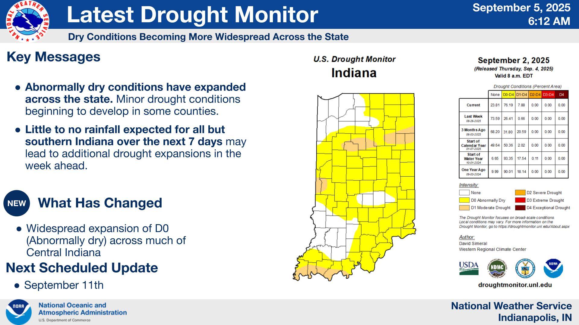
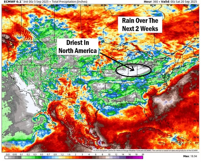
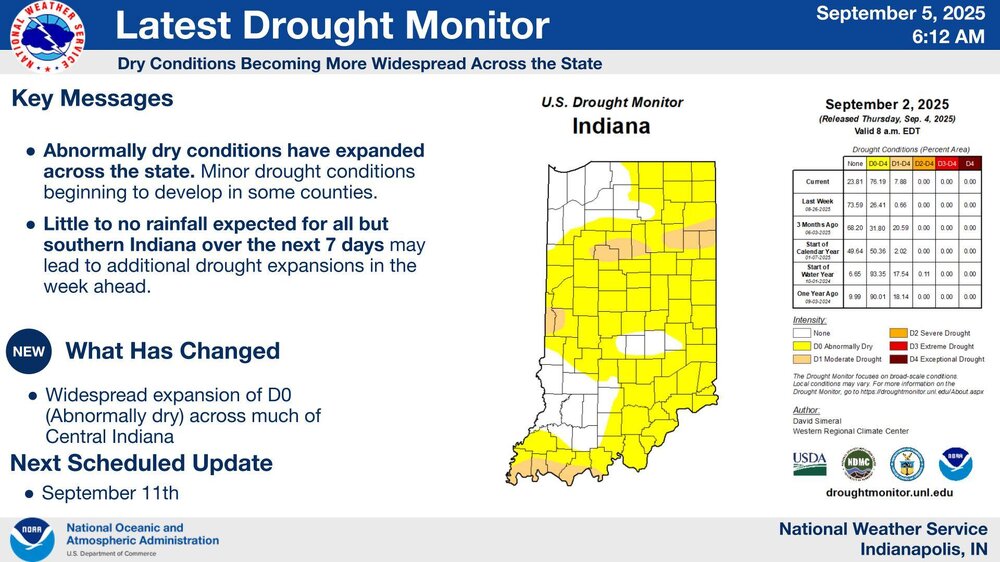
Drought conditions showing up on satellite.

-
Leave it to Spartman to declare summer cancel. Dayton expected 85-90 for the next seven days. A couple of those 89-90’s may be too low
-
Look like they will have the perfect weather for it during the next couple of weeks across our area per the Euro
-
@Jackstraw It's pretty interesting how different weather can be over a relatively small area with similar terrain and elevation. While you eregetting pounded over and over earlier this summer, I'm in drought.
-
My CoCoRaHS gauge caught only .64" in August. Lawn is completely dormant.
-
Do you really want LE rain? Wouldn't you want the lake to be as warm as possible going into the winter season? LE rain in August means that air temps are really cool, which would begin a drop in water temps and lessen the differential as we go into the cool/cold seasons. Asking because I don't know the answer.
-
Unfortunately, I called that one. 935 AM EDT Fri Aug 1 2025 /835 AM CDT Fri Aug 1 2025/ ...AIR QUALITY ALERT IN EFFECT UNTIL MIDNIGHT EDT TONIGHT... The officials at the Indiana Department of Environmental Management have declared an Air Quality Action Day, in effect through today...Friday August 1. An Air Quality Action Day for PM 2.5 has been issued. Fine particulate levels are expected to be in the Unhealthy for Sensitive Groups range. Active children and adults, and people with respiratory disease, such as asthma should limit prolonged outdoor exposure.