IWXwx
-
Posts
6,629 -
Joined
-
Last visited
Content Type
Profiles
Blogs
Forums
American Weather
Media Demo
Store
Gallery
Everything posted by IWXwx
-

-
-
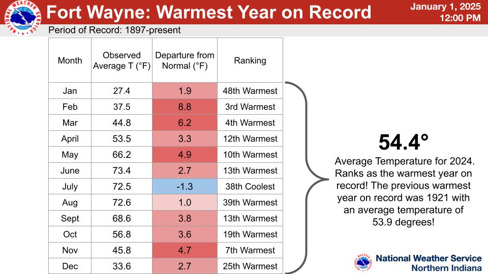
FWA smoked the 1921 record for warmest year by a full half a degree. Had it not been for the anomalously cool July, it would have much worse. Eleven out of 12 months at least a full degree or more above average is nuts.
-
Getting hammered with a second line now. We have been getting some serious rain in the past few days. Good bye drought.
-

Winter 2024-25 Medium/Long Range Discussion
IWXwx replied to michsnowfreak's topic in Lakes/Ohio Valley
As Rocky told Bullwinkle in the old cartoon, "That trick never works." At least it never seems to. -
The top nine are all in the past 23 years.
-
ho ho ho
-
Winter 2024-25 Medium/Long Range Discussion
IWXwx replied to michsnowfreak's topic in Lakes/Ohio Valley
Todd Holsten. A very good met. I’ve done tornado surveys with him. But his discussions are always short. I’ve seen three sentence discos. -
Winter 2024-25 Medium/Long Range Discussion
IWXwx replied to michsnowfreak's topic in Lakes/Ohio Valley
At least Canada is cashing in, FWIW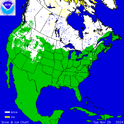
-
?
-
Let’s talk winter!! Ohio and surrounding states!! 24'-25'
IWXwx replied to buckeye's topic in Lakes/Ohio Valley
You're aiming high there, aren't you? 24'-25'? Last year, I didn't even get 2'. -
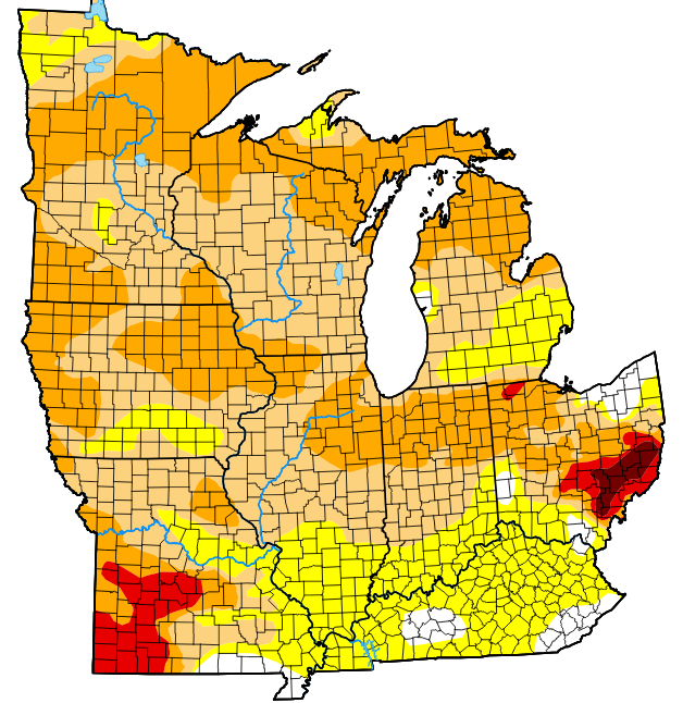
Yes. My understanding is that it's crazy dry down there.
-
Yeah, I don't think my .13" a few days ago is going to put much of a dent in that map.
-
They didn't break it, they destroyed it.
-
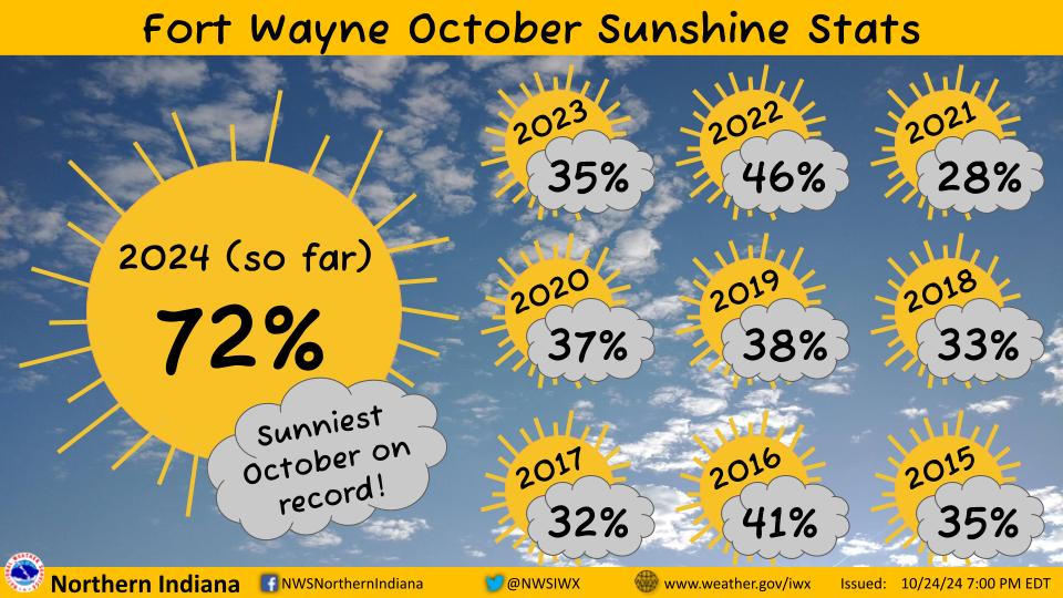
I've been lovin' this October. No wonder Spartman hasn't been here whining.
-

-
Uh...I think we need some rain around here.
-
2024 Short/Medium Range Severe Weather Discussion
IWXwx replied to Chicago Storm's topic in Lakes/Ohio Valley
I KNEW that I should have made a play on the warm front, but decided against it at the last minute. I even know the road network pretty well up there. Also, the storm motion was such that it would have been an easy chase. It was a marginal threat for spinners and it was expected that they most likely would be fairly weak, but you don't get very many chances to chase in this part of the country. Public Information Statement National Weather Service Northern Indiana 450 PM EDT Wed Sep 25 2024 /350 PM CDT Wed Sep 25 2024/ ...NWS Damage Survey for 09/24/24 Event... Thunderstorms developed along a warm front, resulting in the development of a total of 4 tornadoes. We would like to extend our thanks to the spotters, public and media outlets that passed on reports during the event, as well as emergency management officials that assisted in investigating the damage. ..Noble County IN EF1 Tornado... Rating: EF1 Estimated Peak Wind: 105 mph Path Length /statute/: 7.47 miles Path Width /maximum/: 0 yards Fatalities: 0 Injuries: 0 Start Date: 09/24/2024 Start Time: 04:13 PM EDT Start Location: 2 SSE Ligonier / Noble County / IN Start Lat/Lon: 41.4319 / -85.5737 End Date: 09/24/2024 End Time: 04:36 PM EDT End Location: 2 ESE Topeka / Noble County / IN End Lat/Lon: 41.5236 / -85.4971 Survey Summary: This tornado started just east of Engle Lake, knocking down some trees in a residential area. As it continued northward, some of the strongest damage was sustained to a house, which had some of its roofing ripped off and a wall pushed in. Other houses and farm buildings sustained roof damage and more trees were knocked down or snapped as it continued on crossing highway 6. One large chicken building had its entire outer shell removed. It came to an end just before the Noble/Lagrange county line. ..Lagrange County EF1 Tornado... Rating: EF1 Estimated Peak Wind: 95 mph Path Length /statute/: 1.92 miles Path Width /maximum/: 125 yards Fatalities: 0 Injuries: 2 Start Date: 09/24/2024 Start Time: 05:01 PM EDT Start Location: 2 NE Oliver Lake / Lagrange County / IN Start Lat/Lon: 41.5975 / -85.3706 End Date: 09/24/2024 End Time: 05:08 PM EDT End Location: 2 SSW Plato / Lagrange County / IN End Lat/Lon: 41.6176 / -85.3453 Survey Summary: The storm that caused tornadic damage to Noble county intensified again and moved northeast. After initially dropping down around the intersection of 300 S and 300 E it continued northeastward damaging barns and knocking down trees. It completely destroyed one barn building and ripped the roof off and knocked the walls down from a chicken housing structure. The tornado dissipated shortly thereafter in a field. A buggy was blown over in the 2900 block of County Road E 300 S, with 2 occupants suffering minor injuries. .St Joseph IN EFO Tornado... Rating: EF0 Estimated Peak Wind: 70 mph Path Length /statute/: 0.29 miles Path Width /maximum/: 260 yards Fatalities: 0 Injuries: 0 Start Date: 09/24/2024 Start Time: 05:49 PM EDT Start Location: 2 E Indian Village / St. Joseph County / IN Start Lat/Lon: 41.7065 / -86.185 End Date: 09/24/2024 End Time: 05:51 PM EDT End Location: 3 NNW Mishawaka / St. Joseph County / IN End Lat/Lon: 41.7071 / -86.1793 Survey Summary: The combination of video relayed by local media and an NWS storm survey concluded that a weak tornado occurred. The tornado began in the vicinity of the east side of the Meier store parking lot. Medium sized tree branches were downed near the beginning of the tornado path. The tornado tracked east and affected the La-Z-Boy Furniture store and the Potbelly restaurant where some large tree branches were downed. The tornado crossed North Main Street with some additional medium sized tree limbs downed near Raising Cane's restaurant. The tornado then dissipated over an adjacent field to the west of the St. Joseph Health System medical facility. .Camden MI EF0 Tornado... Rating: EF0 Estimated Peak Wind: 65 mph Path Length /statute/: 0.11 miles Path Width /maximum/: 50 yards Fatalities: 0 Injuries: 0 Start Date: 09/25/2024 Start Time: 06:22 PM EDT Start Location: 2 SE Camden / Hillsdale County / MI Start Lat/Lon: 41.7376 / -84.7356 End Date: 09/25/2024 End Time: 06:23 PM EDT End Location: 2 SE Camden / Hillsdale County / MI End Lat/Lon: 41.7382 / -84.7336 Survey Summary: Minor damage occurred to 2 barns on Austin Road, between S Edon Rd and Gilmore Road. The circulation was only briefly on the ground with estimated wind speeds of around 65 mph. -
2024 Short/Medium Range Severe Weather Discussion
IWXwx replied to Chicago Storm's topic in Lakes/Ohio Valley
@HillsdaleMIWeatherThat cell that's been periodically dropping them across Northeast IN is in your neighborhood. You on it? -
2024 Short/Medium Range Severe Weather Discussion
IWXwx replied to Chicago Storm's topic in Lakes/Ohio Valley
You need to make better choices in life. Seriously though, you'll never see a team lose that many games again. You will hopefully get the chance to see a 'nader. -
Didn't there used to be quite a disparity between MDW and ORD? They were pretty close to each other this year. Also, didn't RFD tend to run warm?
-
2024 Short/Medium Range Severe Weather Discussion
IWXwx replied to Chicago Storm's topic in Lakes/Ohio Valley
Preliminary survey results from the Jay County tornadoes, EF-U and high-end EF-1 Public Information Statement National Weather Service Northern Indiana 107 PM EDT Mon Sep 23 2024 /1207 PM CDT Mon Sep 23 2024/ ...NWS Damage Survey for 09/22/2024 Tornado Event.. .Overview... A low topped supercell develop Sunday evening west southwest of Portland. ...Jay County Tornado... Rating: EFU Estimated Peak Wind: 0 mph Path Length /statute/: 0.21 miles Path Width /maximum/: 50 yards Fatalities: 0 Injuries: 0 Start Date: 09/22/2024 Start Time: 07:42 PM EDT Start Location: 2 NNE Blaine / Jay County / IN Start Lat/Lon: 40.427 / -85.0383 End Date: 09/22/2024 End Time: 07:44 PM EDT End Location: 2 NNE Blaine / Jay County / IN End Lat/Lon: 40.4273 / -85.0345 Survey Summary: This supercell produced an initial small, short track tornado in a corn field just east of the Salamonie river south of CR W 75 before it dissipated. ...Portland Tornado... Rating: EF1 Estimated Peak Wind: 110 mph Path Length /statute/: 2.19 miles Path Width /maximum/: 75 yards Fatalities: 0 Injuries: 0 Start Date: 09/22/2024 Start Time: 07:45 PM EDT Start Location: 2 NE Blaine / Jay County / IN Start Lat/Lon: 40.4274 / -85.0274 End Date: 09/22/2024 End Time: 07:51 PM EDT End Location: Portland / Jay County / IN End Lat/Lon: 40.4331 / -84.987 Survey Summary: A second stronger tornado developed immediately downstream near the intersection of W 75 S and Joan Dr and quickly gained intensity as it tracked east northeast, hitting the Portland high school which sustained considerable roof damage. Several homes nearby and further east on the west side of Portland sustained roof damage along with considerable tree damage noted along the track of this tornado. -
2024 Short/Medium Range Severe Weather Discussion
IWXwx replied to Chicago Storm's topic in Lakes/Ohio Valley
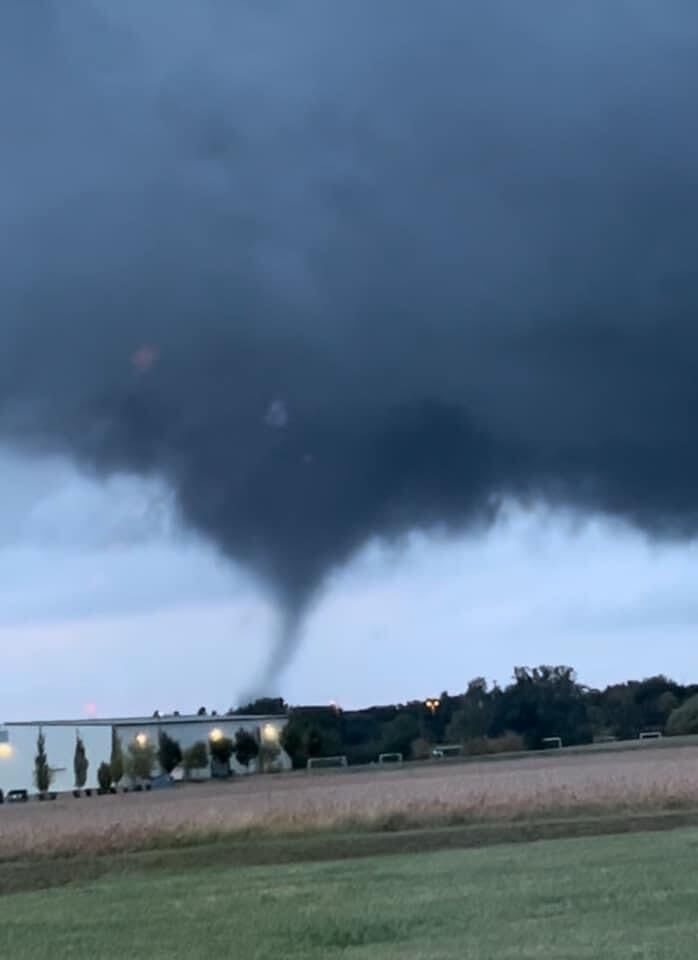
Out of the blue (or gray), two tornadoes touched down last evening within 50 miles of here. One in Jay County, near the town of Portland, and other between Yorktown and Muncie in Delaware County. Both are in East Central IN. IWX is calling Jay Co. a traditional tornado, while there is some speculation at IND about the Delaware Co. tornado: "It may have been a 'hybrid' tornado with some storm scale rotation and some more landspout-like stretching of vertical vorticity processes occurring, but that's speculation." A friend of mine from Yorktown messaged me a pic of that one that he caught.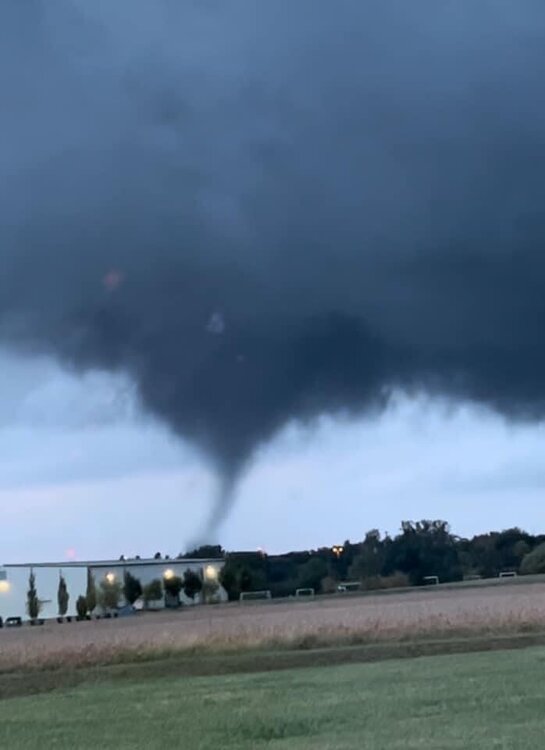
-
Caught 0.54" here yesterday. Not a drought buster, but let's see what tonight/tomorrow brings.
-
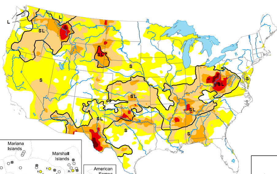
Also, looking at the national map, with drought in Tennessee, Arkansas, Mississippi, and Alabama, how will this affect moisture advection from the Gulf? Or from the southwest for that matter? I really don't know much about this, if anyone can help. Besides, someone's gotta pick up the ball from Hoosier.