IWXwx
-
Posts
6,629 -
Joined
-
Last visited
Content Type
Profiles
Blogs
Forums
American Weather
Media Demo
Store
Gallery
Everything posted by IWXwx
-
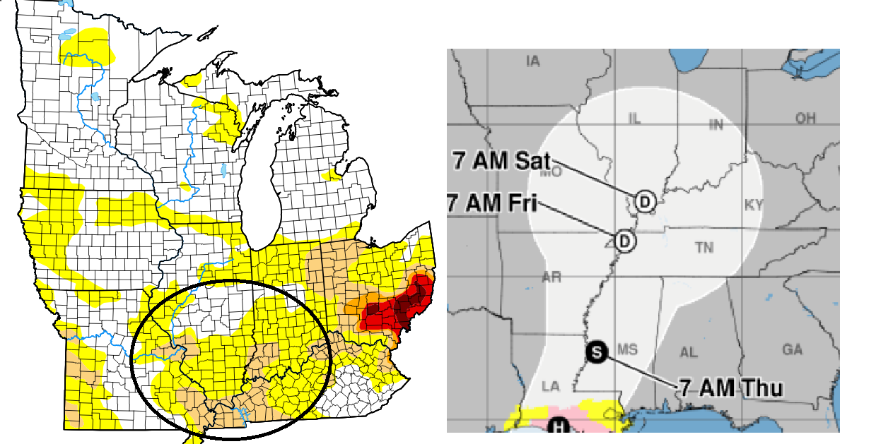
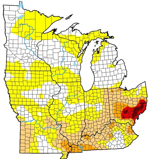
I understand. You guys up there are in good shape compared to us. I am basing drought on the National Drought Mitigation Center data. The moderate drought area along in the Ohio River Valley and along the IN/OH line will spread north and west quickly in the next week and will likely encompass most or all of Ohio (of course), Indiana, Kentucky, Illinois, Missouri, and maybe Iowa and Southern Wisconsin. That would be a large area of drought if it holds or intensifies. I am just curious how it would affect our weather this winter. Does drought beget drought in the winter?
-
Has any one done research concerning drought conditions going into winter and the resulting winter outcomes in our subforum?
-
The burn bans in Indiana are spreading like wildfire. (See what I did there?) With fine fuels quickly drying, field fires become an issue. I already saw a couple of dust devils in fields yesterday.
-
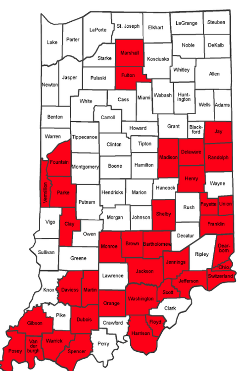
That D1 will be moving west in Indiana on Thursday
-
Endless days of beautiful weather. Best climo
-
I'd be good with this pattern all the way through mid-October, damned the drought.
-
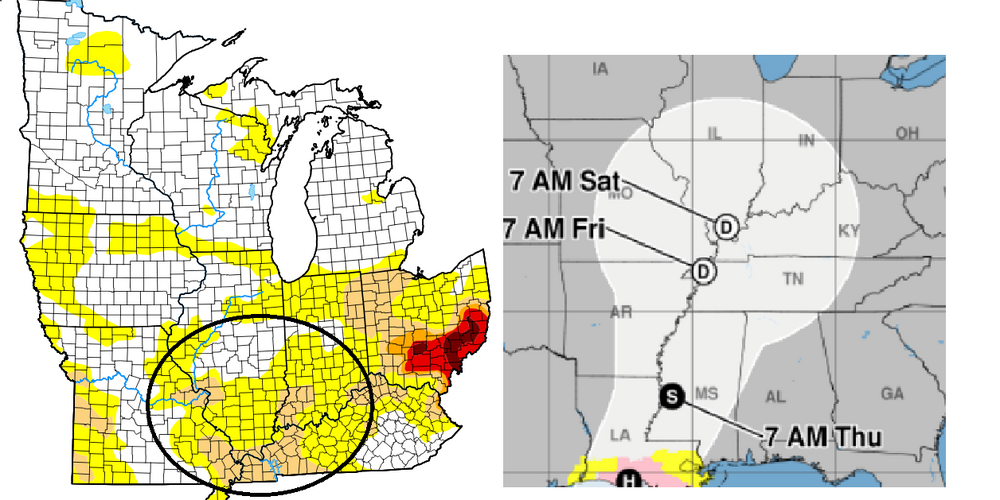
At least Francine should bring a little drought relief to the Mississippi Valley and perhaps the extreme southern part of the sub. Southern Ohio wants a right turn signal. The ULL could create a sit and spin scenario.
-
Upper 30's tonight here too. Then the heat begins to build back in with no rain in the forecast for the next seven days. Everything will be cooked by next weekend. The Ohio drought is creeping westward.
-
-
SBN broke their record high before 2 PM, reaching 97. The old record of 96 was set in 1948. Keeping an eye FWA, whose record is also 96. They jumped from 93 to 97 on the intrahour from 2:30 to 2:35 (EDT), then dropped to 95 at 2:40, and has been sitting there ever since.
-
Coincidentally, I just did my annual seal last week. I used to only do it every three years or so, but I just do it every year now and don't have to use a much sealer on each coat.
-
The media has latched onto ET, so the buzz is now “corn sweat.” It’s the new “polar vortex” and “atmospheric river.”
- 231 replies
-
- 1
-

-
- absolute trainwreck?
- abandon all hope?
- (and 1 more)
-
A nice stretch of warmth incoming for the next week. I'm looking at REAL heat for Tuesday, as my point n click predicts 97. I suspect an Ohio poster will be on here complaining that he got 99'd.
- 231 replies
-
- 1
-
-
- absolute trainwreck?
- abandon all hope?
- (and 1 more)
-

2024 Short/Medium Range Severe Weather Discussion
IWXwx replied to Chicago Storm's topic in Lakes/Ohio Valley
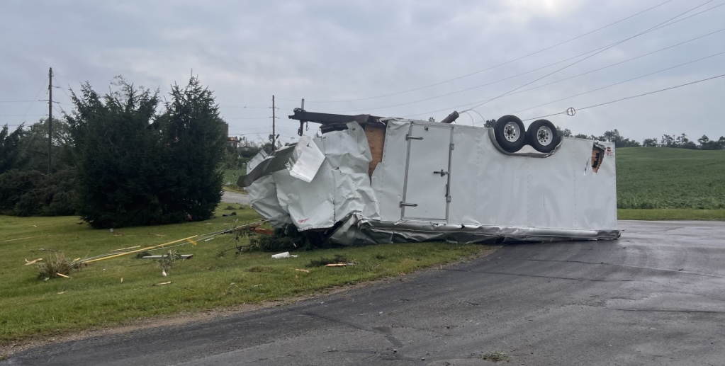
Final call, EF-2: Saint Joseph County Michigan... Rating: EF2 Estimated Peak Wind: 115 mph Path Length /statute/: 8.46 miles Path Width /maximum/: 700 yards Fatalities: 0 Injuries: 0 Start Date: 08/06/2024 Start Time: 08:19 AM EDT Start Location: 2 W Howardsville / St. Joseph County / MI Start Lat/Lon: 42.0333 / -85.7616 End Date: 08/06/2024 End Time: 08:33 AM EDT End Location: 1 NNW Three Rivers / St. Joseph County / MI End Lat/Lon: 41.9616 / -85.6348 Survey Summary: A tornado touched down Tuesday morning at the county line border, just north of Lewis Lake. The tornado did significant tree damage and snapped power poles along the entirety of Berry Ln. The tornado moved southeast towards Day Rd where it reached maximum width of approximately 700 yards. Here, a well anchored manufactured home was slid approximately 5 feet off its foundation, along with significant tree damage. Near the intersection of Bent Rd. and Floating Bridge Rd. the tornado completely destroyed a barn. Farther east on Floating Bridge Rd., the tornado removed a two-story barn roof completely off and moved it about 30 feet away. The tornado reached maximum intensity of EF-2 along Floating Bridge Rd. Another barn roof received major roof damage, the residence's roof was partially removed, and significant tree damage was also observed. The tornado continued southeast crossing Mount Zion Rd with major tree damage and center pivots being overturned. Near Pulver and Null Rd., 8 power poles were snapped, an irrigation pivot was twisted, and minor/moderate roof damage was observed to three homes. Farther southeast along Cowling Rd, a well constructed shed was moved 20-30ft away from its foundation and part of the structure was thrown into the Rocky River. Finally, the tornado caused minor roof damage to a warehouse along N. Main St in Three Rivers. While a portion of the roof was thrown into the trees across the street, it is believed this is where the tornado terminated. -
2024 Short/Medium Range Severe Weather Discussion
IWXwx replied to Chicago Storm's topic in Lakes/Ohio Valley
The Michigan tornado will be rated at least EF-1. This was just sent out by the IWX WCM: Our damage survey of St. Joseph is complete. We can confirm at least an EF-1 tornado from north of Lewis Lake at the county line, went southeast and ended on N Maine St. in Three Rivers. We will internally discuss amongst us at the office on rating and estimated wind speed, but it was at least on the upper end of an EF-1. Thank you for your patience and assistance. Somebody back at the office will release a PNS shortly containing much of the same info. It might be this evening before official path width/length and wind speed are released. -
2024 Short/Medium Range Severe Weather Discussion
IWXwx replied to Chicago Storm's topic in Lakes/Ohio Valley
The damage path is from east of Marcellus to the north side of Three Rivers, MI. If it turns out to be a tornado touchdown, how anomalous is that, an AM tornado in Michigan?
-
2024 Short/Medium Range Severe Weather Discussion
IWXwx replied to Chicago Storm's topic in Lakes/Ohio Valley
IWX is receiving numerous damage pictures from areas that paralleled the rotation on radar from this morning’s warned supercell. EMA is currently investigating and will report later this afternoon, the results of which will determine whether surveys will be completed.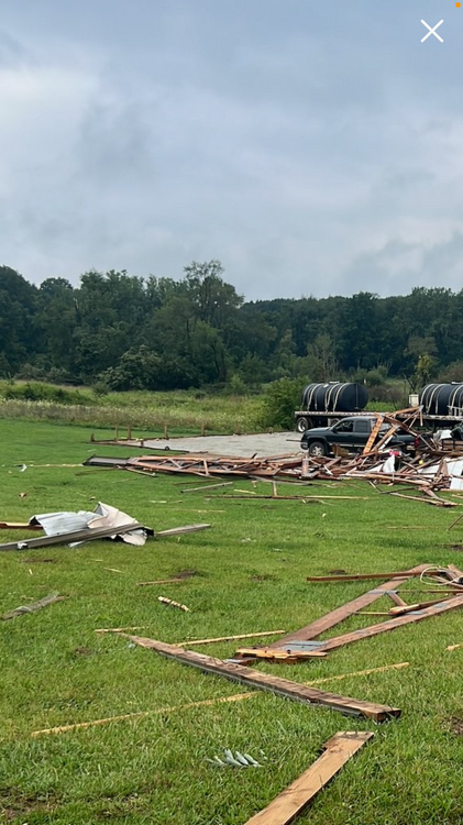
-
2024 Short/Medium Range Severe Weather Discussion
IWXwx replied to Chicago Storm's topic in Lakes/Ohio Valley
I blame Rick McCoy, a fellow Emergency Manager for that. He was originally a broadcast met in Ft. Wayne and has been the EMA Director in Van Wert Co., OH for decades. I always said that severe weather follows him wherever he goes, and Wan Wert County has seen a disproportionate share of severe weather, including numbers of tornadoes, in this region over the past 25 years. -
Same here. NWS had showers or showers and storms in the forecast in our area all week, ranging from 30%-80%. Total rainfall for the week? 0.27" Multiple MCS's formed in Missouri, Iowa, and points west and north, moved through Illinois and western Indiana, only to die when they reached US 31. At least Central and southern Indiana had some action.
-
Midway's only two days ahead of O'Hare?
-
When did you move to San Diego?
-
Caught 0.69 this morning and another 0.54 this afternoon for 1.23" total. We didn't get the big totals from Beryl down this way, but have 3.21" in the past six days, with several more rounds possible in the next couple of days.
-
2024 Short/Medium Range Severe Weather Discussion
IWXwx replied to Chicago Storm's topic in Lakes/Ohio Valley
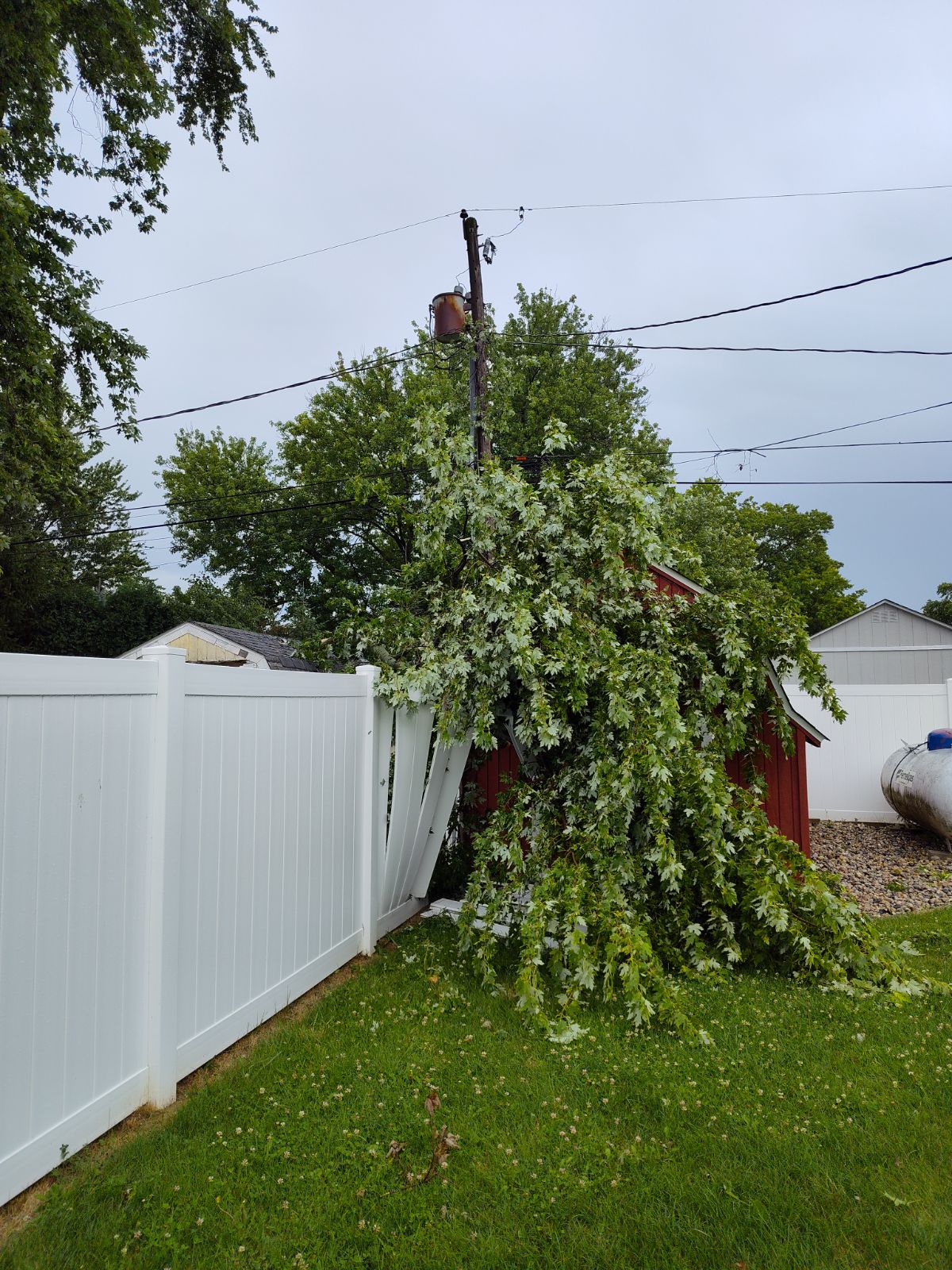
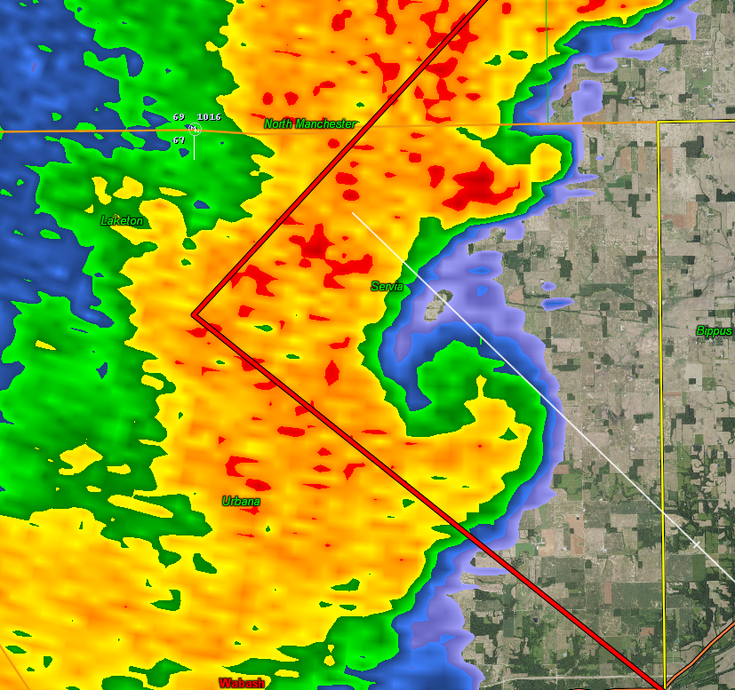
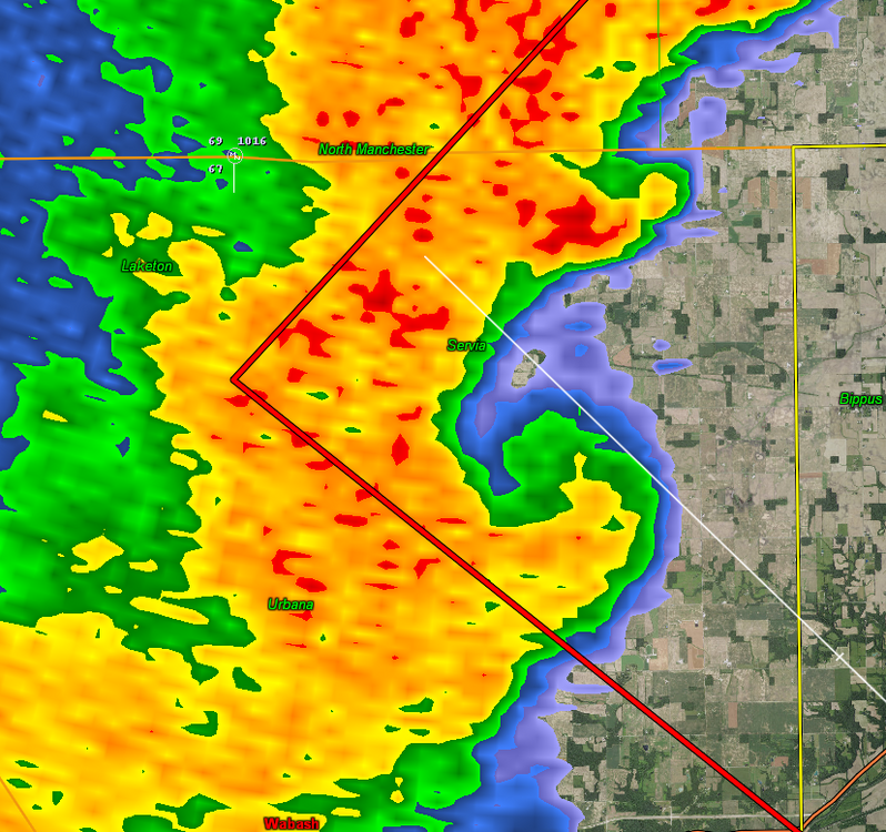
LOL at SPC in issuing a Watch for our county at 12:46 PM EDT, 20 minutes after IWX issued a warning for us, which was promptly canceled an hour later. I was out spotting and only got a 48 MPH gust, but there were a few trees/limbs down in the area, including a limb into my daughter's brand new fence and shed. The rest of the tree is leaning against the power pole in the background. There was a nice little feature on radar as the line approached (I failed grab the couplet on velocity) that had me concerned, but nothing came of it.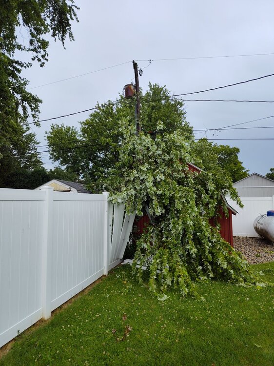
-
2024 Short/Medium Range Severe Weather Discussion
IWXwx replied to Chicago Storm's topic in Lakes/Ohio Valley
This morning’s 3k NAM is trash. Didn’t initialize correctly, not even picking the storms currently rolling through Chicagoland this morning -
One of my favorite times of the year in Indiana with multiple rounds of nocturnal boomers possible Sunday-Tuesday nights.