

IWXwx
-
Posts
6,629 -
Joined
-
Last visited
Content Type
Profiles
Blogs
Forums
American Weather
Media Demo
Store
Gallery
Everything posted by IWXwx
-

2024 Short/Medium Range Severe Weather Discussion
IWXwx replied to Chicago Storm's topic in Lakes/Ohio Valley
Just wow. Good video of it destroying structures -
It was mentioned that this is just like tracking a winter storm. And just like a winter storm, I seem to always get the rug pulled out from under me. Just because I trusted the Euro. Northwest trend FTL once again.
-
You have to be old like me to get this one

-
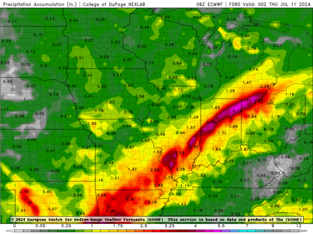
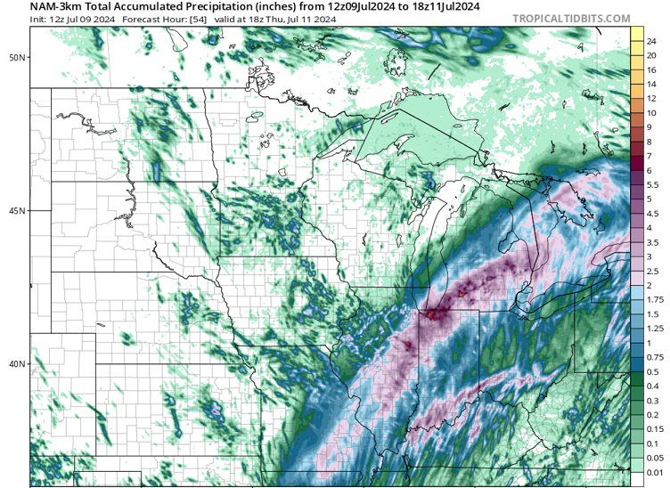
Got 1.54" in about 2 1/2 hours this morning, along with some nice rumbles. However, 15 miles north only had .22". Rain pretty much formed overhead and kept backbuilding on the prefrontal trough. Looks like anything else before the front rolls through later will be isolated/scattered..
-
Hoosier's gotta be beside himself
-
I just realized that FWA set a record for the warmest lows for four nights in a row from Monday through Thursday, with temps never getting below 70. Yesterday morning got down to 69 and this morning's low was 72, but 1988 said "Hi."
-
Nothing beats the smell of petrichor, except actually getting the rain of course.
-
Wind farms are really showing up well on radar this morning
-
The subtitle of this thread is “Stick a fork in it already.” What’s not to like about the most beautiful weather to begin June that we’ve experienced in years in this part of the Subforum, and to now get to enjoy a nice early summer heat dome, with possible some ring of fire action?
-
NOW we’re talkin’
-
It is shocking to me that the southern UP barely received my seasonal average.
-
The real bust is here. A couple of days ago, NWS had my area of Northern Indiana with a 60% chance of rain yesterday and an 80% chance last night. Then yesterday morning they dropped the chance for daytime rain 30% after 2 PM, but continued the 80% chance last night and 90% chance all day today. Waking up to clear skies, no overnight rain, and still an 80% chance, but only after 2 PM. I think I'll go ahead and water my garden this morning.
-
Turn around. Don’t drown.
-
Let’s talk winter!! Ohio and surrounding states!!
IWXwx replied to Steve's topic in Lakes/Ohio Valley
Cue Spartman -
Temperature Forecast Fail
-
1.65" overnight in Huntington. I was just checking CoCoRaHS reports around the state and amounts vary wildly, ranging from under two tenths to over 3.5". For example, two stations less than 15 miles from here: Columbia City 0.2 NE - 0.26" and Fort Wayne 1.9 SSW - 0.31".
-
I would be happy with cooler than normal from mid-May on
-
Hi. Looks perfect for this old retired guy to go on a back yard chase. As I get older, I am shying away from driving for hours. A small target area with ideal chasing terrain, as @nwohweather alluded to, and a familiarity with the road network makes this a go for me.
-
The bottom one is called a Majesty Palm. I don't know much about it except it is also supposed to be cold hardy.
-
Absolutely no complaints about the spring weather we've enjoyed in Northeast Indiana. I couldn't walk out of the local garden center without picking a couple of these beauts. No, I wasn't influenced by palm dude, but maybe by the above normal temps we've enjoyed this spring.
-
Kinda. I’ve had cool weather crops in for three weeks (carrots, onions, peas, strawberries, cabbage, lettuce, potatoes). I was planning on doing the sweet corn, cukes, beans, tomatoes and peppers in the next couple of days. However, that’s on hold for a couple days due to the overproducing rain this afternoon. That’s not unusual for April, as I will end up with over 7 1/2” for the month. Fortunately, it looks like top shelf weather here until at least Friday afternoon.
-
The wettest April on record is assured for this area. The record is For FWA is 7.19". They have recorded 6.69" before the early morning rain today. I have already caught 7.32" imby. The past few years, late spring cold has meant late garden planting. This year's it's plenty warm, just too wet. The upside is that the rain has been pretty spread out over previously dry soil, so nothing more than nuisance flooding has occurred.
-
You got 99'd.
-
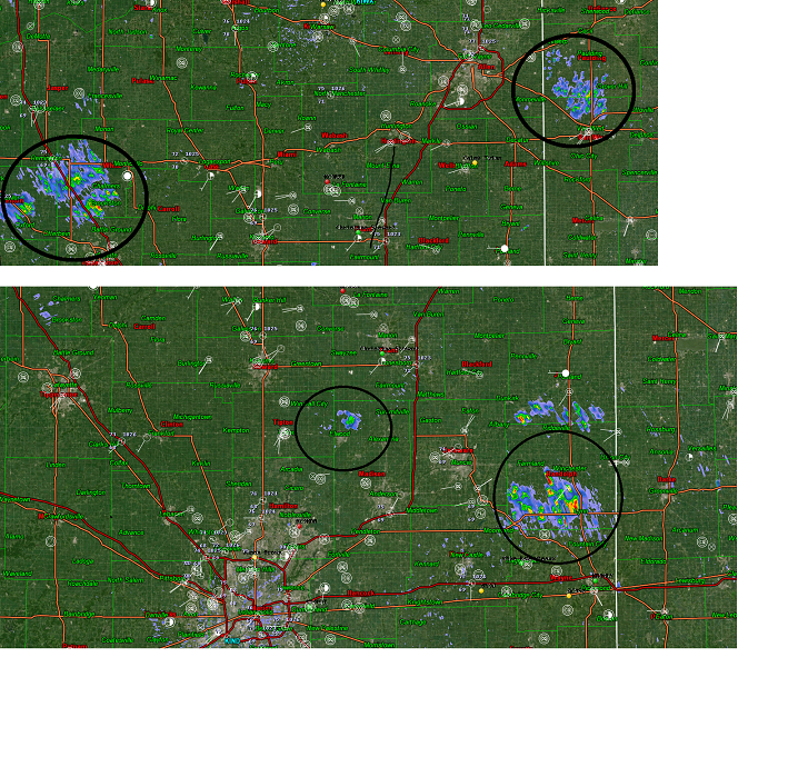
IWX received damage reports near Pennville, IN. Subject called and reported that he watched neighbor's shed get blown off and claimed it was a tornado. They received other damage reports nearby. The Jay County EMA director is enroute to do an assessment. Here is the radar grab from that time-frame. I guess there could have been a quick spinup.
-
KFWA also switched to hourly at 12:55 (Eastern time) yesterday.


