

mitchnick
-
Posts
28,570 -
Joined
Content Type
Profiles
Blogs
Forums
American Weather
Media Demo
Store
Gallery
Everything posted by mitchnick
-
Central PA Fall Discussions and Obs
mitchnick replied to ChescoWx's topic in Upstate New York/Pennsylvania
Over in the MA forum. Sometimes I get lost... -
A thing of beauty upstairs too.
-
Gefs look as good as can be expected at this point imho with the threat.
-
I'm too old to get this excited!
-
Dr. No sucked last year with way too many false Yeses, so screw it.
-
What kind? Good or bad...
-
Pivotal is very close to those maps too.
-
Trailing upper level low is the signature of a great storm too.
-
Gfs has been hitting hard on this 12/3 threat for days. That's often the sign of legit threats.
-
Looks classic for some
-
We're good.
-
Gotta love Gfs temp anomalies after the snow and sleet fest.
-
-
Central PA Fall Discussions and Obs
mitchnick replied to ChescoWx's topic in Upstate New York/Pennsylvania
Where the hell is Bliz? 0z Gfs is a dream for most here. -
Gfs colder with the 12/3 threat than 18z. Gotta watch this one. A bit convoluted, but there's a cold High up north doing some dirty work.
-
Negative? Not considering the Eps AI I posted and the 18z Gefs. The weeklies change so much and have been too warm this fall. The weeklies have such low skill because modeling skill at their range is poor, I honestly no longer put any stock in them. If other people wish to, that's up to them. If you noticed, even Don Sutherland includes more hedges on his analysis than an English garden. But like I said in my post, I think discussing modeling that has such poor skill is just the source of unnecessary angst. I'm not suggesting it should be stopped, it's just useless imho.
-
The weeklies change every day! In 3 days they will be different and it will be a new concern. The fact is, the modeling just can't do what we want and hope for it to do. As I get older, it's clear that long range modeling must be viewed with an eye on seasonal trends, both in the actual weather and the model errors/biases. IOW, how have the models been doing with medium and long range forecasts of late and what is the general tenor of the weather. This year, modeling has general been too warm at longer ranges and it frankly hasn't been a toaster oven for the past few months. All this considered, advertised medium/long range warmups should be viewed skeptically until they start to prevail. Until then, don't worry about it at all. And on a related note, it maybe fine to dissect every medium and long range model run because it's what we do. But until the mr/lr modeling can prove they are worth anything by being accurate and do so with day-to-day consistency, they cause more useless angst than they're worth imho and making forecasts off them with any certainty as I see being made are folly. Enjoy the cold Thanksgiving holiday weekend (another sign of the coming winter flavor) and forget about December's weather until December! Rant over.
-
18z Eps AI sorely lacking warm temps over the period once past Thanksgiving Eve. https://www.pivotalweather.com/model.php?m=eps_aifsens&p=sfct_anom-p105090-imp&fh=loop&dpdt=&mc=
-
Reality will be nothing like that map, so no need to fret.
-
Yes, Op now that I look at it. I thought it was the ensembles on Pivotal. Too any models, and I never thought that would ever come out of this weenie little mind of mine.
-
It falls at the end of the run. It takes a slp system far enough to our west and a cold High in Quebec doesn't budge as it goes to our west and weakens. Cold air holds on and probably ends as drizzle or -rn. For those old enough to remember, Thanksgiving Sunday night into Monday morning 1978 had a similar setup and dropped 3.5+" around BWI and IAD. DCA was closer to 2" I think.
-
With 3.4 at -.7C and underwater temps at -2c+, it wouldn't fade too fast imho. But it would hopefully end the typical, overwhelming Niña crap we often see in winter. In any event, if I had a choice, I'd roll the dice with what the Eps is showing.
-
Nah, he just stopped taking his meds.
-
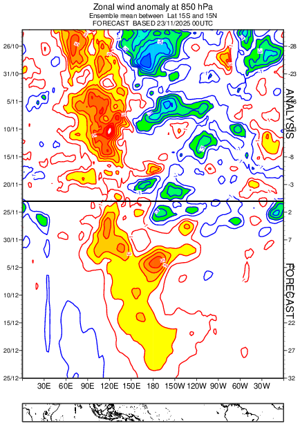
Today’s Eps again says bye-bye to the Niña by Christmas with a serious westerly wind burst anomaly at 850mb.
-
Not one model had BWI BN for November, though the Cansips was the closest while still being a bit AN. Yet, thru yesterday, BWI is -.1. After this week's cold shot, BN for the month is a virtual guarantee. So eff the back and forth of the models because this Fall has been finding a way to squash threatened warm-ups into average or below. THAT'S what's important imho.


