frostfern
-
Posts
1,984 -
Joined
-
Last visited
Content Type
Profiles
Blogs
Forums
American Weather
Media Demo
Store
Gallery
Everything posted by frostfern
-
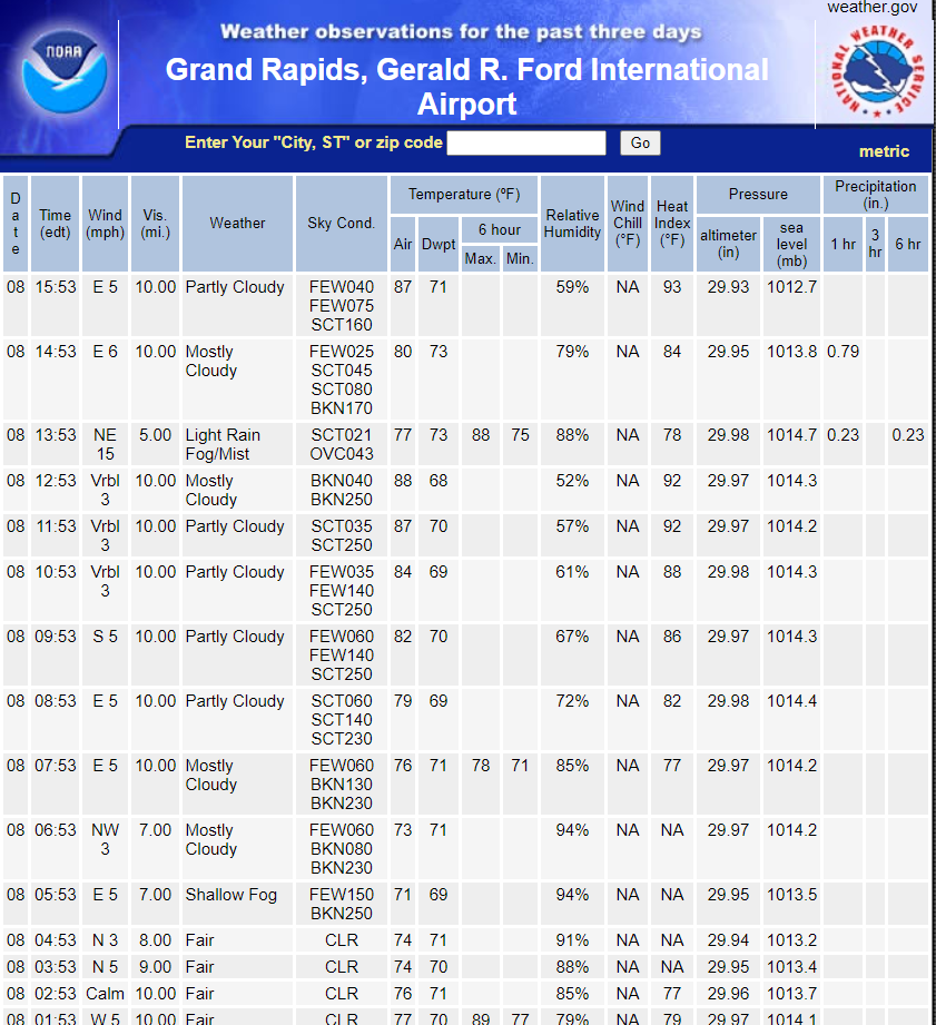
There is a lot of low-level dryness. Areas closer to the lake seem to be overcoming the virga onset quicker.
-
The front end is 100% virga here so far. There's been some radar returns aloft for a while now but the low level dryness is eating it all on the way down. Not that I'm expecting more than 1-3" here.
-

Winter 2020-21 Medium/Long Range Discussion
frostfern replied to Hoosier's topic in Lakes/Ohio Valley
I can skip any repeat of the February 2019 ice-mageddon. Did a number on my poor trees. Just give me snow damnit. -
Winter 2020-21 Medium/Long Range Discussion
frostfern replied to Hoosier's topic in Lakes/Ohio Valley
Hoping we finally get into a classic clipper train with arctic intrusions after the rainstorm on the 4th. It's been a long time. Lake ice on Lake Michigan is still minimal so enhancement looks good. -
It's been remarkably boring. Maybe set a record for the amount of non-sticking 35 degree snow lol.
-
It's the same thing a lot of places this year. Good totals in the mountains but not much elsewhere due to marginal boundary layer coldness. The Adirondacks got dumped pretty good too.
-
Winter 2020-21 Medium/Long Range Discussion
frostfern replied to Hoosier's topic in Lakes/Ohio Valley
Well, it looks like it will at least be less of a snooze-fest than the winter so far. It looks more like a roller-coaster-ride than a winter lock-in though. -
Surprised I didn't make people salty saying I'm happy to get some LES from this. The phantom synoptic event on the ECMWF messed up the Christmas Eve LES scenario by turning the wind too northerly as happened almost all last winter. I think last year set a record for the number of completely snowless cold outbreaks here IMBY. It made me understand Chicago people better. Here in the snow belt cold usually comes with some snow but last year was really frustrating.
-
I actually prefer the GFS. Rather get rain on Christmas Eve followed by an arctic blast out of the west that's guaranteed to give at least some sticking snow than a thread-the-needle synoptic event with the low deepening too far east for good lake effect. Last year was just awful in terms of zero notable lake effect events in West Michigan... then a couple unwanted wet slops well after the first spring thaw. Ugh.
-
Decent wishcast for GRR. The last one that looked like this at this range dumped 2" of rain and zero accumulating snow though. Previous runs had better lake effect events for me on Christmas day. Would really prefer the main low to move closer to James Bay for westerly cyclonic wrap-around. This coastal-low dominant crap brings cold with little LES.
-
December 11th-12th Potential Winter Storm
frostfern replied to Thundersnow12's topic in Lakes/Ohio Valley
Yea. I don't think it was a situation where there was a deep warm intrusion aloft as there was not much in the way of sleet or mixed precip anywhere. The lowest km or so just needed to be a few degrees colder and it would have been a very significant dumping. I was holding out hope that the models might be wrong but no such luck. Perhaps if the same pattern had occurred later in the winter with an established cold boundary layer in place. I remember March 2, 2002 was a decent surprise wet dump of snow. -
December 11th-12th Potential Winter Storm
frostfern replied to Thundersnow12's topic in Lakes/Ohio Valley
Not sure. I think it was just a sharp gradient. GRR and MKG also got narrowly missed. Frustrating as there was a lot of H2O coming out of the sky. It just never changed over, not even towards the end. When the temperature finally got below freezing the precip stopped. Maddening. -
I think the northern periphery will make up for the lack of triple digit temps with horrible humidity. Missouri and Iowa are going to see the highest actual temperatures because it's been dry there.
-
Ridge is delayed a few days now. Tuesday cold front looks stronger and wetter maybe. I think when the ridge finally builds it will have soupy humidity with it... so nasty heat index values. Mid-to-upper 70s dewpoints and low 90s looks more likely than triple digit heat.
-
I finally did good. Parts north and west still didn’t get anything though. Waiting for the rain to the west. Hopefully it at least gives the lakeshore counties a good soaking. Hope it still has convection late. MCSs typically become stratiform by morning with such weak shear. There’s a good low pressure with it so maybe it will hold together despite skinny CAPE and weak shear.
-
Slowest moving MCS ever over Lake Michigan. The lake doesn’t need anymore water. Such a tease.
-
There was lots of thunder here, but it was almost all soft rumbles from the middle part of the cloud. It don’t know what it takes to create a lot of CGs. I kept watching the rain shafts for big strikes but they never came. Just flashes and soft peals.
-
Well it finally rained good IMBY. 0.8” at least with a string of training cells. Still pretty hit and miss though. Hope the bigger MCS to the west makes it here too.
-
Nice isolated storm inland from Ludington. I cloud see the tower blossoming up through the haze from here. I thought it was much closer. It seems like storms can pop up closer to the lake there because there's significant hills. Southern Lake Michigan is surrounded by flat so it's hard for anything to pop up.
-
I think there will be SE diving ridge-rider MCS activity at some point. The problem with this stagnant pattern is the showers don't move very fast. They pop up in one location and rain themselves out, so instead of a 0.25" spread over a general area you get an inch falling over an area of a a few square miles and nothing nearby. I notice a lot of little mesoscale micro-climates with a pattern like this here in Michigan due to slight terrain differences. Storms like to pop up near Jackson and Ann Arbor because there's a slight ridge there. There also some pretty high terrain west of Cadillac in the northern lower peninsula that's been getting showers almost every day. Low areas and areas too close to bodies of water miss most of the time.
-
Good. Maybe there will be a chance of ridge-riding complexes turning right / driving SE into the heat. I'm so tired of this hot dry pattern with the jet up in Canada and organized convection confined to the northern border.
-
Funny how it didn't even rain enough to get the pavement completely wet here, yet 3 miles away it rains an inch in an hour. Pin-prick-sized stationary lake-breeze shower lasted 40 minutes. Surprised there was no thunder. There's a lot of moisture in the air, but it only comes out in one small random location. Lots of places are very very brown.

-
Yea. We got some of those in late May this year. When there was easterly flow during the blocking pattern there just wasn't enough moisture for anything to pop up. No easterly, but today winds were virtually calm and a pulse shower (no thunder) due to the lake breeze dropped an inch of rain at the airport. I'm only 3 miles away and there wasn't enough to completely wet the pavement. It just sprinkled a few huge drops of rain. With dewpoint near or above 70 showers that form are super efficient precip-generators. The problem is they form in one random place and don't move.
-
Yea. The rex-block really dried out the eastern great lakes. The block has finally broken down, but the jet is still too far north to propel any Wisconsin MCS into the Great Lakes. Light westerlies with little shear and no nocturnal low-level jet is a dry pattern for me.
-
I never said that. Just that the pattern sucks and it's getting dry here too, especially north of I-96 and east of 131 where the June 26 MCS didn't give much rain. It's frustrating seeing Wisconsin hog all the rain and thunder with this airmass popup pattern. It's not as dry as the eastern side of the state yet, but that's mainly just the fact that there was quite a bit of rain June 9 - 11. Since then it's been getting dryer and dryer here too.