

frostfern
-
Posts
2,267 -
Joined
-
Last visited
Content Type
Profiles
Blogs
Forums
American Weather
Media Demo
Store
Gallery
Everything posted by frostfern
-
In the summer you can get decent CAPE without super steep mid-level lapse rates because there's more moisture. In the spring mid-level lapse rates are everything. Once large scale convective precipitation occurs, it not only cools the boundary layer, it warms the mid and upper levels through latent heat release. You can't really recover the cold temps aloft with surface heating alone. They need to advect back in from the west. That's my take on it.
-
April is definitely Big Dog Season for the northern plains. High elevation areas in and around Denver get clobbered some years too.
-

Spring 2022 Medium/Long Range Discussion
frostfern replied to Chicago Storm's topic in Lakes/Ohio Valley
I just hope the next warmup features some sunshine along with the warmth. -
Thursday is garbage day. My mom was driving and a bin blew into her car and cracked the windshield. I guess it suddenly blew into the road and there was no time to swerve or slow down. Bad day.
-
Warm and wet beats cold and grey by a little. Disappointing even here though.
-
Stuck in the low cloud soup all damn day and won't even hit 70. Sure, the dewpoint is 62, but if you're not outside to feel that it doesn't look much different from a gloomy day an the upper 40s. Then it's back to cold. Tomorrow is gonna feel nasty with the wind. Feeling kinda hopeless looking at the long range. GFS is probably cold biased after 7 days, but still too f**ing long. Just hoping the next warmup isn't another short rainy BS one like this week. Four years in a row now of cold springs and mild falls. Would honestly prefer the other way around. Feels like an AGW pattern shift or something.
-
I have depression when it's sunny. SAD just amplifies it.
-
Best lightning here was Sunday night with the initial warm/occluded front. It was mostly very small cells popping up between 3 and 4 am to my northwest, but somehow they had quite a few of those high-current CGs that shook the ground despite being a good 5 miles away. Just hoping to hear a little bit more thunder this evening before the cold front is totally through.
-
Yea. That southern stream system backs the 500 mb flow to its north. It's a bubble of weak shear and crapvection that has to get out of the way.
-
This is incredible for Iowa. I reminds me of Pilger Nebraska.
-
If it doesn’t hit 70 today or tomorrow its gonna be a while. Accumulating snow is possible IMBY next week. Never fails.
-
It looks like the kind of situation where coverage peaks after dark, but there’s enough instability it won’t even matter. It will just prolong the tornado threat into the late evening. Might get some really long tracked tornadic supercells.
-
The lakes aren't as big of a factor when you have a strong low level jet and with a backed surface wind there can even be some enhancement from the lake breeze. Though they don't tend to produce a directly over the lake, supercells can usually cross it just fine. I think the really big outbreaks had an exceptionally strong westerly dry push off the Rockies. The dryline moved all the way east to the MS river. There was a similar type of event in November of 2013, but of course the heating was less due to the November sun angle. If that kind of synoptic event happened in April with the longer days there could very well have been very large destructive tornadoes into Michigan. As it was there were still a few QLCS-type tornadoes into Michigan with waning instability after dark.
-
Yea. It's not a terrible day, but the front just came through at a bad time. I enjoyed waking up to some claps of thunder around 4am this morning. As much as you can enjoy being awoken too early. Somehow missed the rain completely though. I think a cell passed just barely north.
-
The synoptic warm front will be way north, but Tuesday evening/night convection will have neutralized the steeper lapse rates until more can advect in from the SW. Iowa into Illinois won't have a problem but that's too far to drive. Its so hard to get good instability into S Mich/ or N Indiana this time of year. I guess weak tornadoes can still happen with a skinny CAPE when the dynamics are really amped, but not as fun as something like 4/7/20. That was a weird NW flow situation though. I don't know how the old school outbreaks in the 50s and 70s happened. Somehow there wasn't convection the previous day in the plains to eat up the instability?
-
Hopefully we can do a first 70 tomorrow. 67 on March 17 is the highest so far.
-
2022 Short/Medium Range Severe Weather Discussion
frostfern replied to Chicago Storm's topic in Lakes/Ohio Valley
ECMWF is hinting at a strong MCS rolling east out of Iowa Tuesday evening. It would follow the northern edge of a nice EML plume coinciding with warm sector dews in the lower 60s. There's decent mid-level lapse rates with the first wave on Monday too, but the problem is the dewpoints are only low to mid 50s with that one due to the last cold front completely scouring the GOM. How this first wave plays out will effect where the warm front ends up being Tuesday evening though. -
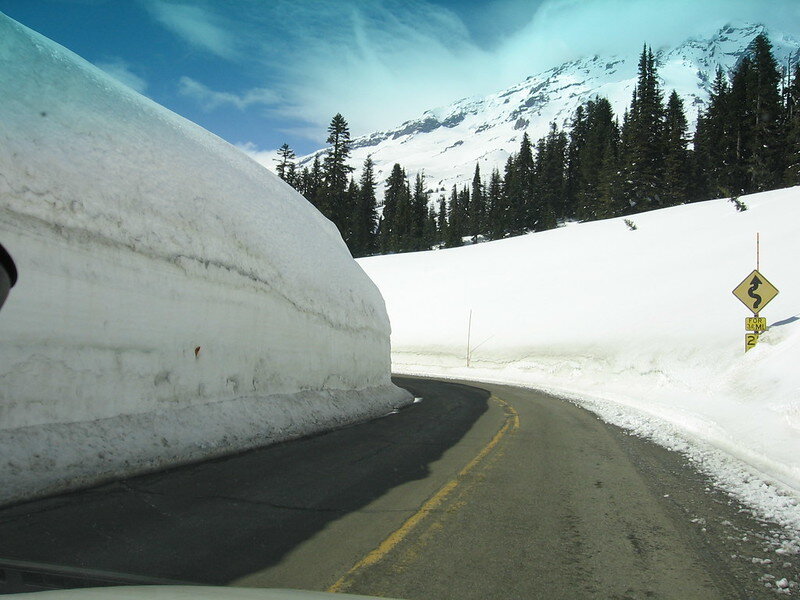
This is what 90" SWE looks like. Mount Rainier in early April 2008. The depth was 19 feet.
-
I’m just annoyed Alek had me thinking the earlier low was 968, not some BS at 200+ hours. Not that the GFS has that much better chance of verifying a bomb inside 200 hours, or even inside 24 if we’re totally honest.
-
At 264 hours.
-
If current op runs verify it could get very warm and very windy. Haven’t seen a 980 low in April in recent years. A little scary if there’s any instability with it.
-
I prefer a share-the-wealth more. Don't need tornadoes, but I'd like enough instability to actually hear some thunder. It's been a long time here. 3/5 had a lot of wind but no thunder here.
-
I lived in Western Washington for 8 years. I noticed the "cloudy" days there are not as solidly overcast as they are here. During cool season there's always that marine instability that breaks up the clouds between showers. You get a lot of mostly cloudy days, but not a lot of solidly overcast days. Solid stratus, when it happens, is more of a late spring and summer problem. There the transition from winter to spring is so boring and gradual you hardly even notice. It's early summer that's extremely changeable, as the weather changes dramatically depending on whether the flow is onshore or not. I prefer the Midwest though. Much more interesting. I could never live in a perpetually scorching climate either.
-
Torch / freeze cycles are a Michigan problem. We have a lot of fruit trees.
-
It looks like a hailer setup with dews in the 50s and steep lapse rates. It's just that the instability doesn't make it very far east.


