frostfern
-
Posts
2,267 -
Joined
-
Last visited
Content Type
Profiles
Blogs
Forums
American Weather
Media Demo
Store
Gallery
Everything posted by frostfern
-
It seems like they always trend the gridded forecast towards climatology. To be honest the Accuweather thing where the forecast is “heavy snow” 8 days out is worse. Would prefer a middle ground. Good thing I read the weather discussions as they will almost always mention a lower-confidence significant event before they’ve committed it to the grids.
-
Typical GFS. Was bothered because the Euro had some nasty cold runs too. It will still take time to push the Hudson Bay cold vortex out, but the Pacific looks better with the jet undercutting instead of building a PNA ridge into Alaska like before.
-
I think it's because models don't handle the processes driving MJO well. I recall studying the MJO ten years ago and the global circulation models would just damp out the MJO over time... unless you tweaked the convective parameterization just right to make it appear (which unfortunately often screwed up other things, so you didn't know if it was appearing for the wrong reasons). Maybe the operational models are better now, but they also used to just crash the MJO into the origin in the long range. That would explain why if the MJO is going into a phase that suppresses the pacific jet and the model just crashes it into the origin, well the pattern is probably going to persist longer than forecast. Back then it seemed like all the models trended to their own biased climatology after 15 days or so... and the MJO is an irregular 20-80 day "cycle". Maybe they have gotten better and can actually forecast the MJO now, but I kind of doubt it.
-
Yea. It's a major eruption for St. Vincent, but it's not even close to a global-scale event like Pinatubo. An eruption of that scale isn't predicted. There are a few other volcanoes around the world that could do some climate alteration if they decided to wake up, but none of those are active right now.
-
This pattern is actually good for flowers. Blooms will not be over in an instant like they would if it stayed as torchy as last week.
-
The fact that the winter minimum temperatures haven't warmed all that much compared to summer maximums is the opposite of what you would assume. My wild guess is it has something to do with changes in lake breeze behavior.
-
It's the "bad for thunderstorms" most of us are complaining about, not the cold. If it's going to be in the low 40s again at some point I'd rather have a snowstorm. Stat padding wet snow is better than total nothingburger weather. I suspect the ridge will lean in from the northwest eventually and early May will turn very warm. Still not a very interesting pattern as moisture return will be slow as typical after such a troughy pattern.
-
Massive 960 mb Aleutian bomb gradually spinning itself out south of Alaska is the problem with the GFS OP. Maybe not all the ensemble members / other models are as bad. Please tell.
-
The ridge will eventually translate east. The problem is that's the most boring transition possible if you are interested in active weather. Warm air advection from the northwest is a drought pattern.
-
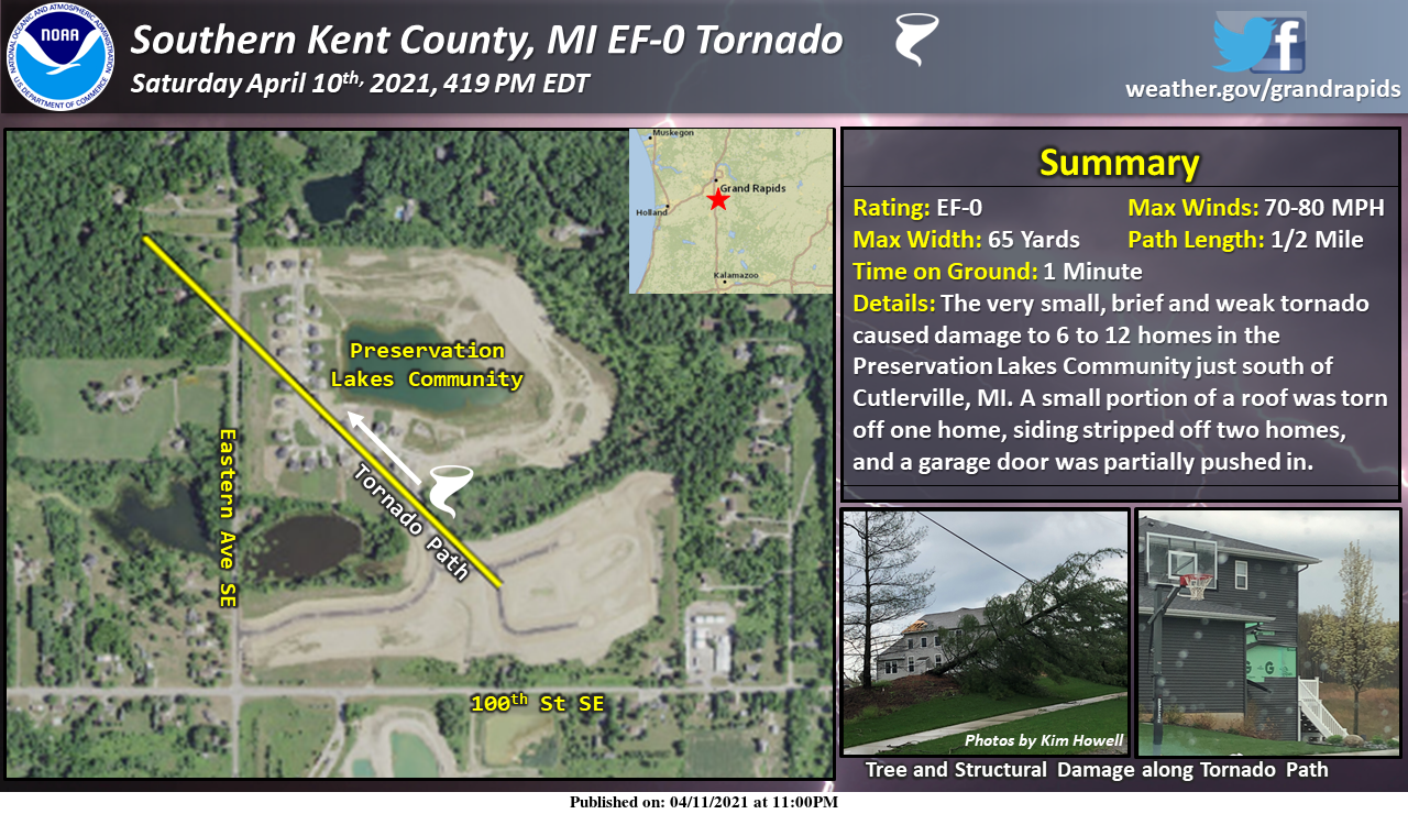
So this is what prompted the severe thunderstorm warning on Saturday. It was odd as there was a lot of thunder and quite a downpour, but hardly any wind at all IMBY. Also weird to see a SE to NW path.
-
We're talking about an increase in the UHI though. It's hard to tell how much of it corresponds to increased urban development and how much corresponds to other factors.
-
Boring blocking pattern ends with a super amplified +PNA ridge into the Yukon and downstream GL trough. Please tell me it's just the OP GFS.
-
It's possible to hit 60 with 0C 850 temps this time of year. Probably not in this moist pattern though. The flip side is it won't be freezing hard at night, so flowers will do well. Would be nice to avoid a hard freeze now that things are ahead of schedule. Still a long ways to go until we're out of the woods though.
-
Just got a nice heavy thunderstorm. Severe warning but nothing close to severe IMBY. Not a lot of wind. Rain came straight down. Just big drops. Water running along the road and grass looking soggy. Was worried the line of showers would be broken given how past systems panned out, but this line is sharing the wealth in terms of rainfall on this side of the state at least.
-
I'd prefer to get those kind of amounts since it's going to be dreary no matter what. It's a dry spring still up here.
-
Long range is really really boring though. Might as well live in Scotland. Just hope this blocking nonsense doesn't last into May. I'm afraid climate change is making boring blocking patterns more common just because the arctic is warming faster than the midlatitudes.
-
Have had three micro-cells drift overhead so far today... each cloudburst lasted approximately 6 minutes... yet deep puddles and water running along the sides of the roads after each one. These cells are very efficient rain producers. Comes in sideways too. South facing window just pounded with big drops. Not too much lightning though. Few scattered strikes but I didn't hear any thunder yet. The cells have been solidifying and producing more strikes as they move away to the northwest.
-
Very small cell just ripped hail for about 5 minutes. It was a little bit bigger than pea sized, but not quite dime size. Nice hour long period of gentle rain and occasional rolling thunder earlier this morning too. Saw some decent anvil crawlers.
-
EML is different from a typical cap in that it features steep lapse rates in the 700-500 hPa layer. 8C/km or greater in this layer usually evidence of an EML. It's good for severe weather because it gives the CAPE a low center of gravity, so parcels accelerate early.
-
Problem is it's the ECMWF too. I wouldn't call it "arctic", just snooze-fest crap where the warm front is close enough to cause clouds, but pushed south by easterlies from Canada.
-
GFS has gone back to the backdoor cold front BS in the long range... like the Euro. Elevated convection with the WAA will probably happen at some point, but who knows if the real warm sector ever makes it here.
-
It looks like the warm front will be north of most of us, so probably plenty of sunshine. The GL backdoor sag idea is gone for now at least, which I like. It's just a matter of coverage. Something has to break the cap at the right time. GFS is now showing a pretty good system coming in from the west later but that's so far out still.
-
At some point there will be an E-W boundary wiggling north and south. Sucks when you're stuck on the north side by 300 miles or less. GFS has trended more towards the euro with a weaker front, so hopefully it hangs up north of the majority of the forum. It's weird how that zonal pattern hasn't really occurred yet this spring though. The longwave ridges and troughs span massive range of latitude, but have at least been moving. Wavy but progressive is nice. Cold fronts tend to be dry up north in this kind of pattern though. Big sprawling high's don't allow quick moisture return in their wake.
-
I don't understand why there isn't an alternate bare-bones radar site. I know they can't use flash anymore, but the layered GIS stuff is just too much until they upgrade to a faster server network. It works nice for climatological data like snow depth and rainfall, but its beyond useless for looping. The new radar color scheme is terrible too. I'd volunteer to fix it if they'd let me.
-
Euro looks thundery for Michigan next week. Something similar to what happened on the 7th last year would be cool.