

frostfern
-
Posts
2,267 -
Joined
-
Last visited
Content Type
Profiles
Blogs
Forums
American Weather
Media Demo
Store
Gallery
Everything posted by frostfern
-
I can't deal with low 70s dewpoints at any temperature, unless I'm not moving at all.
-
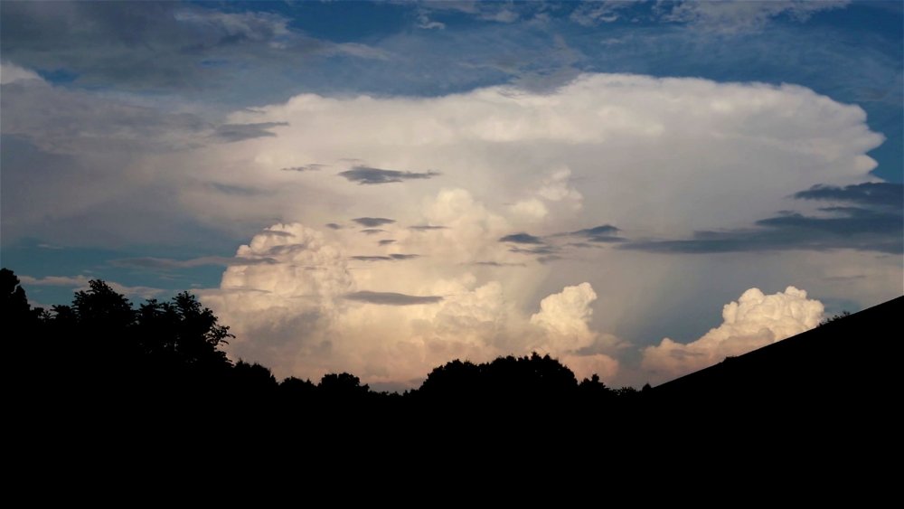
I bet there was a good view from out in the middle of the lake. Here the towers to my west were mostly obscured by anvil precip. Only a few drops made it to the ground IMBY though, along with the outflow breeze. A cluster of pulse cells popped up 50 miles to the east, which I filmed later in the evening. Gotta love the new Tampa Bay climo with easterly "trade winds" lol. Just wish the wealth was spread better.
-
Awesome! I slept through it.
-
I took some video and time-lapse yesterday afternoon. Heard soft distant thunder but didn't get a single drop of rain, just outflow. It was interesting how there was some westerly shear but storms were basically stationary. Low level easterlies cancelled by upper level westerlies. https://www.youtube.com/watch?v=XV-fjaLstpM
-
The sky was nice today with a lot of billowing towers and occasional distant rumbles. Outflow boundaries from small cells that popped up all around kept the temperature in the low 80s, but still barely enough rain to wet the ground IMBY.
-
Here it's Tampa Bay climo. Waiting for something to pop up. Whatever showers form will probably rain themselves out in the same location they formed. Virtually zero wind field today. Good setup for more 2.5" bullseyes with 0.05" 5 miles away... just like yesterday. There's enough instability for lightning if something can get going enough. Didn't hear anything yesterday as it was all pretty shallow showers.
-
The sun is out and theres a lot more instability today, but who knows where the showers will pop. Probably more lightning around today, but good coverage isn’t guaranteed.
-
An extremely localized cloud burst did most of it here. There is one swath from Allegan up through downtown and a few cloudburst spots south and east. One popped up near east grand rapids and dumped for 5 minutes or so adding a half inch almost instantly. The more general light rain band was only 0.1 to 0.2.
-
About 0.7" here. Half of it fell almost at once under a tiny cell, but more widespread lighter rains are also adding up now.
-
Low-topped microcells dancing all around me, but nothing overhead. Once cell up to 30k feet over Ottowa County, but its not moving east at all. Grrrrr.
-
Sun didn't come out enough for lighting here. Figures. Still some good downpours scattered about to the south and west but they are just agonizingly slow to move in.
-
The showers are just slowly inching north... agonizing. All the stronger updrafts with lightning are to the northeast where the sun came out. Hard to get lighting with clouds all day here.
-
So much soup in the air today... yet nothing significant falling out of the sky. Need the sun to come out to kick anything off.
-
The low last night was 69 with a dewpoint around 59. This is a pattern with unusually good mixing for this time of year.
-
Around here I'm more used to seeing an anomalously high dewpoint. Ionia county is always 2 degrees higher than GRR for whatever reason. There it's maybe the reading being taken close to the ground in an agriculture or wetland area vs higher up in a field at the airport. I have never seen 10 degrees off ever though.
-
A good thing is the precipitable water will be very high and the models are showing some shower activity even during the night. It's just the instability might be kinda limited wherever the sun doesn't come out as much.
-
I didn't know the dewpoint is consistently low at that location. People farther from the plains are not used to seeing high dewpoint depressions at night during a heat wave. Farther east the warmest temps in summer are under high pressure with lighter winds, so the dewpoint is the only thing that keeps temperatures up at night outside of UHI.
-
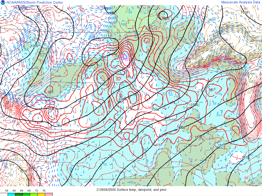
That 90 degree reading looks real. I've heard of heat bursts doing this, but the nearest thunderstorm complex is a long ways to the north.
-
There's something interesting going on near Fargo. That is an 88. It's almost like a heat burst or something. Definitely localized subsidence going on as the dewpoint is way lower than the surroundings. Upper 40s vs upper 50s and low 60s nearby.
-
There's a 40 knot LLJ at 925 mb. That hot blowtorch is mixing down to the surface.
-
There will probably be some kind of MCS or at least a leftover MCV drifting in from the NW along the stalled backdoor front Friday or Saturday. The models are all different, but a transition to NW flow will probably happen and that will favor a more organized MCS diving SE with NW shear. Likely sloppy seconds for the OV and completely miss southwest of Michigan though. Before that it's just a Florida pattern. I'm praying the lake breeze gives me something IMBY.
-
It looks like a Florida-type pattern, which is always full of localized 1"+ bullseyes and holes. Will need at least three or four days in that kind of pattern to get a soaking rain everywhere. Would much prefer an MCS that shares the wealth more, but that's really hard to come by this year. Really tired of backdoor cold fronts and dry easterlies. That crap is getting really old.
-
The west is definitely better than the east for the late evening to overnight complexes that roll in from Wisconsin. Wisconsin itself is even better though, but hard to drive around a lake. The other problem is the timing window is so small here. Too early and storms struggle over the lake and only really erupt again around Lansing. After 6pm they can go elevated more easily and survive the lake, but instability overall is waning. Central and Eastern Michigan used to get supercells once in a while, but the shear just hasn't been around in a long time.
-
I just don't get excited at all over temperature records and droughts... as opposed to actual weather. Might as well move to southern California if that's all we have to talk about these days.
-
Every once in a while there's a good one in late August or early September here. Spring and early summer has been dead for years.


