frostfern
-
Posts
1,984 -
Joined
-
Last visited
Content Type
Profiles
Blogs
Forums
American Weather
Media Demo
Store
Gallery
Everything posted by frostfern
-

Feb 12-14th V-Day Weekend Potential Stuff
frostfern replied to Chicago Storm's topic in Lakes/Ohio Valley
Narrow FGEN bands can sometimes squeeze out what limited deeper moisture there is, but it will be 50% shallow lake moisture. -
Feb 12-14th V-Day Weekend Potential Stuff
frostfern replied to Chicago Storm's topic in Lakes/Ohio Valley
Chicago stealing all the lake enhancement this year. ZZZZZ.... IMBY. -
Winter 2020-21 Medium/Long Range Discussion
frostfern replied to Hoosier's topic in Lakes/Ohio Valley
I can see places like Gary, Indiana getting dumped with a deformation-band / lake-effect combo. Widespread snows look meh. Boring on this side of the lake except far southwest corner maybe. -
That dendrite aggregate stuff has a knack for sticking to things despite being dry. Also piles up perfectly on benches and deck railings, provided the wind isn't too strong.
-
Winter 2020-21 Medium/Long Range Discussion
frostfern replied to Hoosier's topic in Lakes/Ohio Valley
Don't know if mother nature is more offended by premature storm threads or you calling her a b..... -
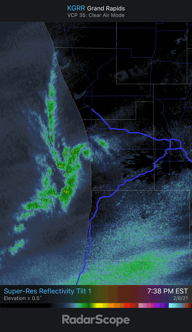
New southern meso has developed a nice eye. Coolest thing ever.

-
There are two meso-lows now. Northern one is dissipating while the southern one intensifies. Southern one now has an eye.

-
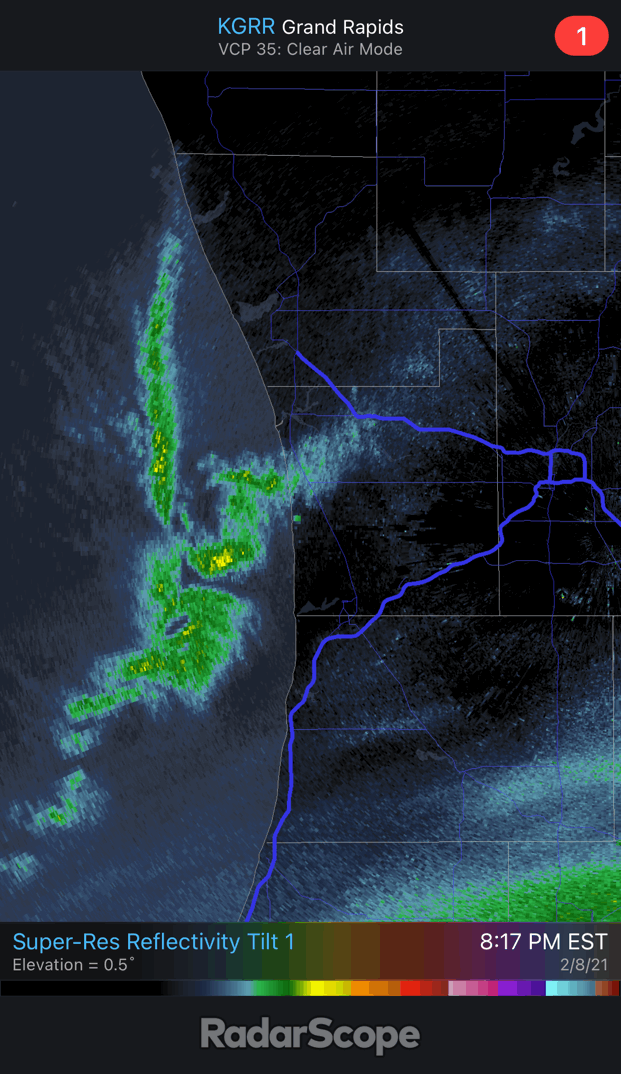
You are close enough to the lakeshore that a mesolow can make landfall and dump. Small area south of Grand Haven may get crushed if it moves east. Don't know if it will though. There's an easterly land breeze pushing the band offshore on the north end. Seems pretty stationary. GRR is way too far inland. Even if it were to move east it would dissipate.
-
Stunning offshore mesolow. Like a mini snow hurricane. One of the cooler things to see on radar.
-
This is really cool...

-
Mesolow band offshore from Holland is absolutely dumping over the lake. Too bad it isn't moving inland. Frustrating.
-
Winter 2020-21 Medium/Long Range Discussion
frostfern replied to Hoosier's topic in Lakes/Ohio Valley
18z was garbage, but 00z is at least looking more like the ECMWF. Will probably regret staying up to see it tomorrow morning... but whatever. -
Winter 2020-21 Medium/Long Range Discussion
frostfern replied to Hoosier's topic in Lakes/Ohio Valley
The problem is the more non-boring weather and weenie model runs we get, the higher the expectations get. It's like heroin. Dammit. -
Winter 2020-21 Medium/Long Range Discussion
frostfern replied to Hoosier's topic in Lakes/Ohio Valley
Or just wait until the event is less than 48 hours out... Usually at that point you can at least know whether the waves are going to phase and blow up into a legit storm or remain a strung-out dud. Can still get screw-zoned with last-minute track-shifts though. -
Yea. It's way more complicated than temperature. The highest ratios seem to be from shallow clouds with a cloud-base dewpoint around 10-15 degrees. When dewpoints at the cloud base are in the single digits or lower the snow gets more dense again as you have mostly diamond dust plates. It's lighter than a wet snow, but denser than fluff. Lots of drifting decreases the ratio as well because the aggregate flakes get broken up into individual crystals and land flat. Snow that has blown off the roof can be especially dense even when it's cold. Wind-sculpted cornices can be rock-hard and exceptionally dense, probably because the loose flakes all blow away leaving very dense semi-fused crystals behind. Also, snow that forms in really deep strong updrafts is denser due to rimed flakes. Light-intensity lake-effect is more fluffy than the stuff that falls from really intense bands. It seems a bit of a nonlinear curve. Very weak vertical motion will produce mostly plates due to supersaturation not being great enough for dendrites. Moderate vertical motion will produce big dendrite flakes that form aggregates and really boost the fluff factor. Extreme vertical motion leads to rimed flakes and eventually graupel, which is dense.
-
18z GFS is whack.
-
Winter 2020-21 Medium/Long Range Discussion
frostfern replied to Hoosier's topic in Lakes/Ohio Valley
Expectations went from 0 to 100 over the past week. -
Winter 2020-21 Medium/Long Range Discussion
frostfern replied to Hoosier's topic in Lakes/Ohio Valley
5G waves aren't in the models yet. -
Winter 2020-21 Medium/Long Range Discussion
frostfern replied to Hoosier's topic in Lakes/Ohio Valley
Then it's the other way around when spring comes. Warmth always gets farther north faster the farther west you go. -
Yea. The initial burst of snow Thursday night reminded me of a spring snowstorm out west, like in the mountains of New Mexico or Arizona. There was graupel mixed in with the flakes at times. I wasn't surprised it started producing lighting when it moved farther east, the convective elements got deeper as they moved east.
-
There is a 6" glacier base under the fluff here. I didn't hear thunder Thursday night so you still have bragging rights to that.
-
Winter 2020-21 Medium/Long Range Discussion
frostfern replied to Hoosier's topic in Lakes/Ohio Valley
Extend that map out another day please. There is an epic storm in progress over MI on the 16th LOL. -
GRR reporting over 2" more than what I've measured in my driveway. It's fickle though. Lake effect zone is probably highly variable with more fine-scale streaks than the map shows. Most of it has been falling in localized heavy showers under very narrow bands. Very fluffy with a lot of drifting too. I added up 6" from the synoptic event, then another 4 of lake effect so far. Most of that happened in a 3 hour period when a couple heavier convergence bands passed over between 4pm and 7pm last night. Had a complete whiteout that dropped an inch in 20 minutes around 6:00pm (worst timing with rush hour traffic), but most of the time it has been flurries or very light snow.
-
Really dumping here at times. It snowed about an inch in 20 minutes when I was in the store. It isn't persistently that heavy, but really difficult driving in the most intense bursts. It cranks for 20 minutes, then lets off for a bit, then cranks again. At least 3 inches of fluff in the past 3 hours though. That's on top of the 6 inches from last night. Up to about 9 total.
-
Right under a nice band now. Snowing good with big flakes.