Carvers Gap
-
Posts
17,401 -
Joined
-
Last visited
Content Type
Profiles
Blogs
Forums
American Weather
Media Demo
Store
Gallery
Everything posted by Carvers Gap
-

2/14- 2/16 Winter Storm and Arctic Cold
Carvers Gap replied to WestTennWX's topic in Tennessee Valley
Wow. That is madness. Be sure to post some pics! -
12 RGEM is again a messy onset but more so for NE TN this run with .43 ZR in Sullivan Thursday morning. Looks like the RGEM is seeing the warm nose a bit better this run. Powell was asking about the difference. Ya'll check out the temps Wednesday AM over E TN without snow. I had to look twice. Those temps are going to set the stage for really cold rain or a mess Thursday night in eastern sections.
-
Regarding Weds night/TR the 6z GFS is a total mess...even messier than 0z. RGEM is right there with it. Agree with John on believability stuff. That said, cold bleeding into the eastern valley and getting trapped is a legit option. Whether it happens, anyone's guess at this point. However, the 0z and 6z suites have some significant icing and snow for parts of E TN which did not for yesterday's model runs. Again, the 6z GFS doubled down on its 0z run. Worth a mention...may or may not happen, but a big change. We will see where it goes.
-
NE TN , SE KY, and SW VA folks might want to get a look at the 0z CMC, 0z RGEM, 0z GFS, and 0z Euro(trend on that one). Worth a look. Won’t add more unless the trend holds - might be a hiccup. 0z RGEM was snow for most of E TN. Colder.
-
2/14- 2/16 Winter Storm and Arctic Cold
Carvers Gap replied to WestTennWX's topic in Tennessee Valley
On WxUnderground, I am seeing stations at or below freezing on the north and northwest sides of Knoxville. -
My biggest snow this winter was actually from a lee side low. Always the chance for a Miller A....no way to know this far out of course.
-
2/14- 2/16 Winter Storm and Arctic Cold
Carvers Gap replied to WestTennWX's topic in Tennessee Valley
A generational event. -
Just looking at the EPS this afternoon...looks like the pattern will repeat one more time. NAO does re-fire d10-15. Cold builds out West...bet it slides east as the GEFS extended had last night for the first week of March(late in that first week). This has been the base pattern all winter. Actually, November had the same pattern but climatology fought the cold coming SE. Think Cosgrove is on the right track there.
-
Reposting as I failed earlier to put a time stamp on this comment.... Something to keep an eye on for NE TN and SW VA folks...the 12z Euro is implying that there could be a mix at TRI and snow/sleet in SW VA before the cold is scoured out. edit: Thursday morning!
-
One other thing to watch in the LR, the Euro and GFS again both set a really nice boundary just after d8. To me that is a little bit early. However, maybe we get one more system to run an east/west boundary prior to a brief warm-up to end the month and more winter later during the first week of March. Seems like two years ago, we hit 80 during February here at TRI. LOL.
-
2/14- 2/16 Winter Storm and Arctic Cold
Carvers Gap replied to WestTennWX's topic in Tennessee Valley
Just for posterity, 41 here in Kingsport. What a temp gradient! -
2/14- 2/16 Winter Storm and Arctic Cold
Carvers Gap replied to WestTennWX's topic in Tennessee Valley
They are running out of deep colors of blue/purple for ice! Memphis is close to a huge run there. -
2/14- 2/16 Winter Storm and Arctic Cold
Carvers Gap replied to WestTennWX's topic in Tennessee Valley
For whatever reason, it switches to the most complete run instead of the run in progress. Hiccup in the programming or design. Gets me ALL the time. WxBell has a similar glitch where it will switch to off-run modeling for the Euro when I toggle between it(0z or 12z) and another model. Drives me crazy! -
2/14- 2/16 Winter Storm and Arctic Cold
Carvers Gap replied to WestTennWX's topic in Tennessee Valley
As a heads-up, those are 6z. Pivotal gets me all of the time when it switches runs. -
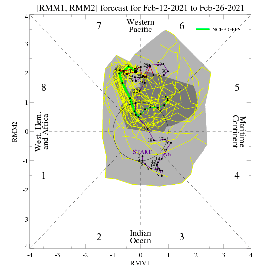
Looks like the NAO tries to refire after d10. The Euro MJO continues to forecast a move into the COD - dives out of 7, head fakes to 8, moves to 6, and then moves back to colder phases. Larry Cosgrove who has done a fantastic job this winter hinted that he thinks we may see the current pattern repeat again during March. The MJO is hinting at that as well. He also has stated that when we break to spring that it will be quite abrupt. He is calling for a scorcher of a summer as well. March can hold a surprise or two. If the NAO re-fires that is a good thing for March...we don’t want that index negative for summer as all.
-
2/14- 2/16 Winter Storm and Arctic Cold
Carvers Gap replied to WestTennWX's topic in Tennessee Valley
The trend Monday into Tuesday is a drastic reduction in temps in the eastern valley. There are places in E TN and NE TN which are 10-15 degrees colder. The CMC and Euro are now showing signs that the front may catch the precip in the eastern valley. Really need to watch this. There is a real possibility that the cold is being under modeled in the eastern valley. -
The 18z RGEM is tracking an areas of weak slp from the Panhandle of FL through the Carolina Piedmont with seemingly little energy transfer. Back side of the slp switches to light snow in ETN. It is on the eastern envelope of storm tracks not implausible. The EPS at 12z moved several of its slp member tracks into the same vicinity as the RGEM.
-
I was thinking that as much as we like to give modeling a hard time(me included), they have been remarkably steady for this. Obviously, I am hoping for a shift for MBY....but they aren't moving much. The CMC is the first hiccup which I have seen.
-
For eastern folks, I do have at least give mild attention to this 12z CMC look for Tuesday. The slp(as is) is likely too weak. However, if that strengthens even a little...that is not benign for the eastern valley IMHO. That is different from what we have seen recently. Modeling has trending towards this inland runner during the past few runs. The para has a similar look but runs a shadow up through the eastern valley which is no good. If the CMC consolidates, that is good. Might just be a hiccup, but the RGEM was pretty much there as well at 84.
-
2/14- 2/16 Winter Storm and Arctic Cold
Carvers Gap replied to WestTennWX's topic in Tennessee Valley
Might not hurt to add Middle/West TN to the thread title or tags so when we go back and search(in future years), it will be easier to find.... -
The 12z CMC/RGEM is developing a low which takes the low road Tuesday. Modeling seems to be split between sending some energy up the west slopes of the Apps and then developing a lee side low or hybrid Miller A OR just going with a Miller A. Some fairly different solutions out there right now regarding Tuesday. ICON/CMC camp vs GFS.
-
Nope. We just follow each threat. Been middle and west for several days. Totally fine with that BTW.
-
Do we need a new storm thread for the next system or just want to rename the other thread as some sort of multi-day overrunning thread? It doesn't matter to me as I have no horse in the race...but what is being modeled is significant. Maybe wait until 12z and then work it.
-
Thanks, man, for keeping our middle and west TN folks in mind. I know we have been focused on the eastern sub-forum areas this winter, but glad we can get the folks out in those areas (who have waited patiently...Memphis has waited seemingly forever) involved in our winter discussions.
-
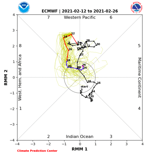
Some fairly significant trends with the MJO today. The EURO is now forecast to hustle out of 7 and even duck into 8 for a couple of days. The GFS is now forecast to hustle out of 7(big trend last it was not even getting out of 7 a few days ago...and looping back into 6 if memory serves me correctly), into the COD, and then back to warm phases. The good news is the MJO is forecast to get out of 7. Now, both head towards warmer phases at some point...but check the EMON (posted it above) as one potential that might occur. I suspect we are about to see some model discontinuity coming up. Often, when we see this push by the Euro...we see changes just after d5. Let's see its next couple of runs. That, at the very least, shows a trough in the East for 3-4 days. With the cold in the pattern right now, 3-4 days of a trough in the east would be nice.