

jm1220
-
Posts
26,186 -
Joined
-
Last visited
Content Type
Profiles
Blogs
Forums
American Weather
Media Demo
Store
Gallery
Everything posted by jm1220
-
Well... snow ending from this part-light stuff/flurries and 3.5" on my tabletop. We'll see what happens later.
-
HRRR is on some serious crack or there's still quite a bit to go for most of this subforum. 01z run just coming out has 0.70" liquid for my backyard, 0.55" for NYC and even 0.40" out by Morristown. Has a pretty good period of snow overhead by around midnight sparked by the stuff coming in from western NY and ends around 5am.
-
Little over 3" here, I'd say 3.2". Dumping snow but this back edge should be here soon. Hopefully we see it filling back in overnight.
-
Who knows? It will forever be lost to history because it's been deleted. All we can do now is speculate and have it live on in our memories. I get this is disappointing for a lot of this forum but there's a banter thread...
-
RAP has the same evolution as HRRR and amounts still to fall so it's not on its own.
-
Might be totally cracked out but who knows.
-
Just under 3", snow picking up again. It's been all snow but inconsistent intensity. Heavy for a couple minutes then a lull.
-
Probably just crappy snow growth caused by poor lift and the mid level warm layer. Another reason why those inflated Kuchera maps should be thrown in the trash. HRRR takes some of that precip in central PA and moves it east and refires it over the next few hours, snow lingers east of the city until 5-6am. Who knows how accurate it is but hope isn't over IMO for at least an advisory event in the city and parts of NJ. From West Milford to New Brunswick and east it has over 0.5" liquid still to fall after 0z and 0.7-0.8" for Suffolk. Someone out by Riverhead might see a foot. I doubt it will be here, some of these crap subsidence areas are surviving past the border. I'm hoping still to get the 7" I predicted last night.
-
And that being said since the system is headed more SE now the sleet line should stop advancing-it’s already headed back west a little and snow should refire/linger through a good part of overnight. Still quite a bit of precip to go on the short range modeling especially from the city and east.
-
It’s a blind squirrel that found a nut. But there were red flags today especially that it could be a sucky precip shield heading into the city and the best WAA snow would overshoot to the NE.
-
I said 3 days ago that these storm types are infamous for trending north at the end and some others like Forky said they can keep trending north until the start. It’s why I personally never root on SWFE/overrunning storms and they’re bread and butter for the I-90 corridor. We get lucky once in a blue moon like Feb’s or Nov 2018 but by and large they suck for our area (S of I-84). Because of the orientation of the high and blocking it’s being shoved SE at the last minute which should be good for my backyard and east this time but lesson number bajillion why we should take big snow outcomes for NYC on models 72+ hours out in this type of setup with lots of skepticism. This isn’t NYC’s type of storm to pile up significant amounts-we need the benchmark Miller A or Miller Bs to come back.
-
I called for 7” for my backyard last night and that’s still looking good. Some parts of CT and further east on LI will probably hit 10”. HRRR/RAP have snow lingering around here for much of the overnight. That was looking like the jackpot zone all day-from eastern half of Suffolk through much of CT and the Hudson Valley/Albany. And it was a risk that with the banding making it that far east it would result in subsidence/shredded crap over the city and west.
-
The system is thankfully starting to move in more of a SE direction so it’s not a west to east dry slot, but it’s pretty clear this will end up on the low end of expectations for most of NJ because of how far N the 700mb low tracked. The best dynamics were over upstate NY.
-
Wow, heavy snow. 2.5”.
-
And another awesome event this season for the Albany area. That area to Hartford and over to Poughkeepsie should all have an easy 6-10" tonight. The snow shield looking like that is what we needed. The best 700mb dynamics and lift were closer to the 700mb low in upstate NY.
-
Some could just be atrocious snow growth too, but soundings from some of the short range modeling were clear this would be an issue.
-
To be honest the precip shield over NJ looks like crap to me with all the holes that are perfect for letting the mid level warm air catch up. The short range models seem to consolidate and fill this in soon, hope they’re right. Sorry to all those guys getting sleet and now we know-we can’t dismiss the NAM when it shows lousy QPF and surging mid level warmth.
-
Just under 2” here, like 1.8”. Flake size increasing again.
-
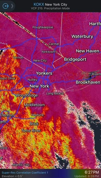
These patches of yellow on the sleet line line up with the swiss cheese subsidence holes and push back a little when the precip increases. But not what I was hoping to see in the radar presentation for holding the sleet back. Last Feb's SWFE was way more organized with the precip so the sleet was slower to advance. Hopefully it doesn't advance too far into the city and it gets its act together for everyone. But those places by I-287 are probably done for much more snow.
-
The sleet line should wash out a bit if the heavy rates can persist for a while. Otherwise those getting sleet and not expecting it-that’s the problem with these systems that don’t come in with persistent heavy rates and these subsidence holes.
-
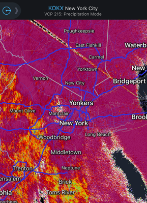
Not really. It sucks but there was subsidence next to the band over Westchester. That said it should be snowing again soon there.
-
Kinda what the HRRR/RAP hinted at-that stuff over NJ should fill in as it heads east.
-
The yellow line was the sleet line a few minutes ago. We'll see how heavier steadier rates can help it fall back west.
-
An inch here already just about. Heavy but with smaller flakes/some dippin’ dots.
-
That mixed bag up by Stroudsburg looks like it will mix out over to snow with better rates. Allentown probably out of luck but we’ll see how much good the better rates can do.


