hawkeye_wx
-
Posts
6,320 -
Joined
-
Last visited
Content Type
Profiles
Blogs
Forums
American Weather
Media Demo
Store
Gallery
Everything posted by hawkeye_wx
-
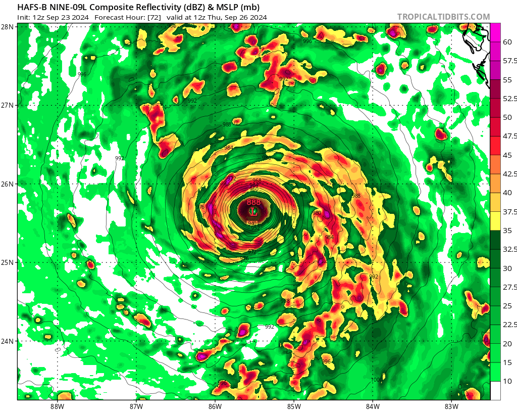
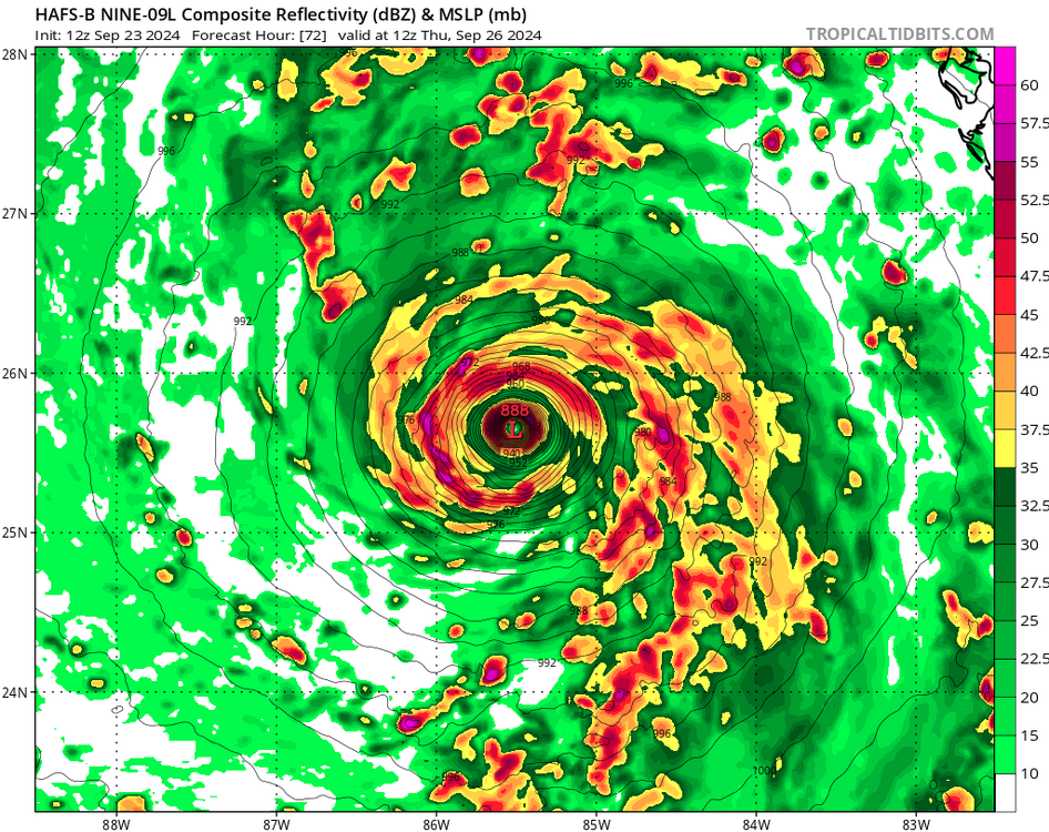
All of the hurricane models are much weaker at 18z because it takes a lot longer to organize. The HAFS-B is 90 mb weaker at 12z Thursday (888 mb to 978). The southerly shear in the nw Caribbean isn't going to help it organize.
-
The three recon passes found extrap pressure of 1008, 1006, and 1005 mb, so it's slowly dropping as the circulation develops.
-
All of the very-intense hurricane models have this system well-organized and deepening to 990 mb by 12z Tuesday. I'd say that is pretty unlikely.
-
Yeah, this isn't something we see every day. It's likely wildly overdone, but it's neat to look at.
-
The weak center of surface spin is currently located ssw of Grand Cayman, northwest of the convection.
-
It is likely the very intense hurricane models are organizing the system too quickly in the nw Caribbean. They are predicting a rapidly-strengthening hurricane before it even reaches the gulf. The Euro, on the other hand, has further-delayed the organization over the last two runs. It now has the system only slowly pulling the energy together over the next two days and reaching tropical storm status, 30+ mb weaker than the overzealous hurricane models at the Yucatan Channel.
-
The big weekend rain event was a massive bust for much of Iowa. I got 0.09". The airport got 0.00". It will likely be the driest September on record.
-
It's too hot and dry. Cedar Rapids hit 91º today, with full sun and no wind. Like Cyclone, we got no rain last night. The Sunday wave is fading on the models, so late Saturday is going to have to deliver.
-
Based on the new recon data from the east/southeast side, 90 mph may be generous.
-
The final recon pass tonight found ~977 mb with a dropsonde.
-
38º in Davenport this morning.
-

2024 Atlantic Hurricane Season
hawkeye_wx replied to Stormchaserchuck1's topic in Tropical Headquarters
This wave is fading on models, at least until it reaches the western Caribbean. -
We really needed rain. After nearly 9 inches in July, we had only received an inch in August. Fortunately, Cedar Rapids hit the jackpot overnight. Storms trained over the area for a few hours. I picked up 2.41". Radar suggests 3+" fell on the east side of the city.
-
It is currently 94/81/115 here in Cedar Rapids. The NWS has had 98º for our high for a few days, but they are always too hot on the hottest days. It's extremely rare for CR to reach the upper 90s. Frankly, while I'm very glad to have air conditioning, I actually get cold inside so I go outside once in a while. This oppressive heat feels great for a few minutes at a time.
-
This summer has not been hot at all. June had seven 90º days, July had two, and August has had zero, with none in sight. The summer high temp was 93º back in mid June.
- 231 replies
-
- 1
-

-
- absolute trainwreck?
- abandon all hope?
- (and 1 more)
-
I was able to get almost an inch of rain overnight into this morning. It was well-timed because the first two weeks of August were very dry and the next week or two looks dry as well.
-
The storm has broadened, so the core is lagging a bit. Recon is finding only tropical storm wind on the west side, and even within the core on the right side. Hurricane-force wind is displaced well east of the center.
-
The surface center is still weak and displaced to the wsw of the nice mid-level center we see on radar.
-
Last night's line of storms held together better than I expected. I got a nice storm out of it, with rain that totaled 0.58". My final July rain total is 8.66".
-
Tonight's big event for my area has kinda been ruined by all the recent action to the southwest. All we have this evening is an outflow-dominated, bubbly line moving through central Iowa. There probably won't be much left when it gets here later.
-
The MCS train has not budged from its track through Ottumwa the last few days. Ottumwa has received 6-7" of rain.
-
As expected, I only got some light anvil rain like Cyclone... about 0.15". The MCS track has been locked in for the last few days. Ottumwa had been the driest spot in Iowa, getting missed repeatedly over the last couple months, but they've been hit by at least five MCSs this week that have dropped several inches of rain.
-
The morning MCS activity across the sw half of Iowa likely ended any chance of storms here until Wednesday night.
-
I finished last night with 1.01". It was heavier just south of me where the storms trained. My July total is up to 7.97", which makes this my wettest July since I began keeping records in 2007. This is just one of those months in which we are maxing out every event. We aren't done, either. There may be more MCS activity Tuesday and Wednesday nights.