hawkeye_wx
-
Posts
6,648 -
Joined
-
Last visited
Content Type
Profiles
Blogs
Forums
American Weather
Media Demo
Store
Gallery
Everything posted by hawkeye_wx
-

Major Hurricane Melissa - 892mb - 185mph Jamaica landfall
hawkeye_wx replied to GaWx's topic in Tropical Headquarters
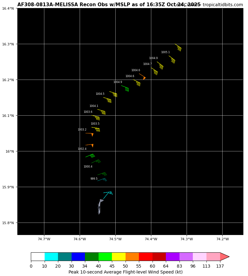
Still 971 mb... no drop over the last 90 minutes. -
Major Hurricane Melissa - 892mb - 185mph Jamaica landfall
hawkeye_wx replied to GaWx's topic in Tropical Headquarters
97 kts flight level, 970 mb extrap -
Major Hurricane Melissa - 892mb - 185mph Jamaica landfall
hawkeye_wx replied to GaWx's topic in Tropical Headquarters
The Google model continues to not budge. Many of its tracks are south of west for the next couple days.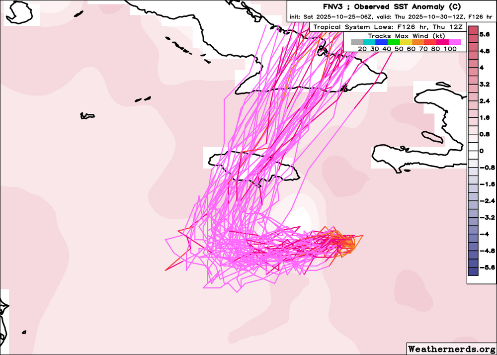
-
Major Hurricane Melissa - 892mb - 185mph Jamaica landfall
hawkeye_wx replied to GaWx's topic in Tropical Headquarters
The favorable conditions really collapse on tonight's Euro once Melissa gets to Jamaica. -
Major Hurricane Melissa - 892mb - 185mph Jamaica landfall
hawkeye_wx replied to GaWx's topic in Tropical Headquarters
Tonight's hurricane models (HWRF, HMON, HAFS) are no longer showing Melissa moving toward the west to the south of Jamaica. They are all now moving the center nw to wnw into eastern Jamaica. -
Major Hurricane Melissa - 892mb - 185mph Jamaica landfall
hawkeye_wx replied to GaWx's topic in Tropical Headquarters
987 mb That should be the final recon pass until morning. -
Major Hurricane Melissa - 892mb - 185mph Jamaica landfall
hawkeye_wx replied to GaWx's topic in Tropical Headquarters
993 mb -
Major Hurricane Melissa - 892mb - 185mph Jamaica landfall
hawkeye_wx replied to GaWx's topic in Tropical Headquarters
Yeah, given the current structure as it moves into diurnal max, it should be a good night. -
Major Hurricane Melissa - 892mb - 185mph Jamaica landfall
hawkeye_wx replied to GaWx's topic in Tropical Headquarters
Track is shifting eastward.
-
Major Hurricane Melissa - 892mb - 185mph Jamaica landfall
hawkeye_wx replied to GaWx's topic in Tropical Headquarters
It appears the surface and mid levels are finally beginning to come together. The convection is looking significantly better organized and now recon is finding the pressure dropping below 1000 mb. Also, the center continues to be pulled eastward while the convection tries to wrap back westward toward the center.
-
Major Hurricane Melissa - 892mb - 185mph Jamaica landfall
hawkeye_wx replied to GaWx's topic in Tropical Headquarters
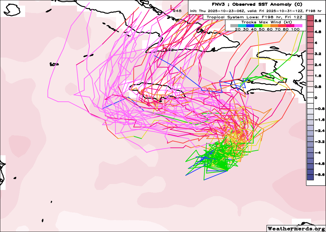
06z Google.... almost all tracks now over Jamaica.
-
Major Hurricane Melissa - 892mb - 185mph Jamaica landfall
hawkeye_wx replied to GaWx's topic in Tropical Headquarters
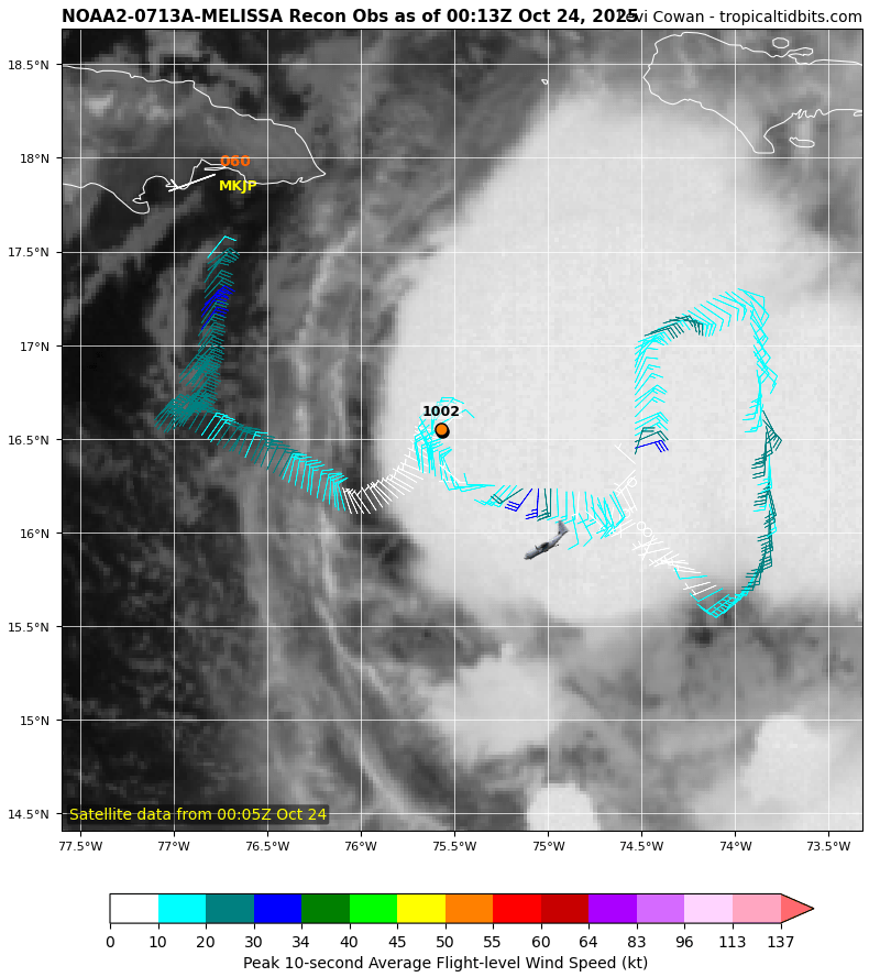
This is a weak and messy circulation.
-
Major Hurricane Melissa - 892mb - 185mph Jamaica landfall
hawkeye_wx replied to GaWx's topic in Tropical Headquarters
Google DeepMind ensembles have shifted back west and south again.
-
Major Hurricane Melissa - 892mb - 185mph Jamaica landfall
hawkeye_wx replied to GaWx's topic in Tropical Headquarters
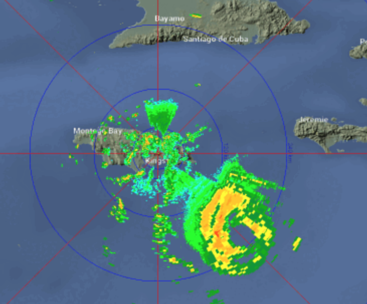
Based on the final recon pass and the visible loop, it appears the center has jogged northwest, and is now west of the NHC forecast. -
Major Hurricane Melissa - 892mb - 185mph Jamaica landfall
hawkeye_wx replied to GaWx's topic in Tropical Headquarters
HAFS models have jumped northeast again this morning. Now they hit Jamaica from the east. -
Upper 20s were scattered across western, northern, and east-central Iowa this morning. The Cedar Rapids airport briefly hit 28º. Here in the city there was just a light skin of ice on the bird bath and some light frost. Tomorrow morning should be a bit colder.
-
Major Hurricane Melissa - 892mb - 185mph Jamaica landfall
hawkeye_wx replied to GaWx's topic in Tropical Headquarters
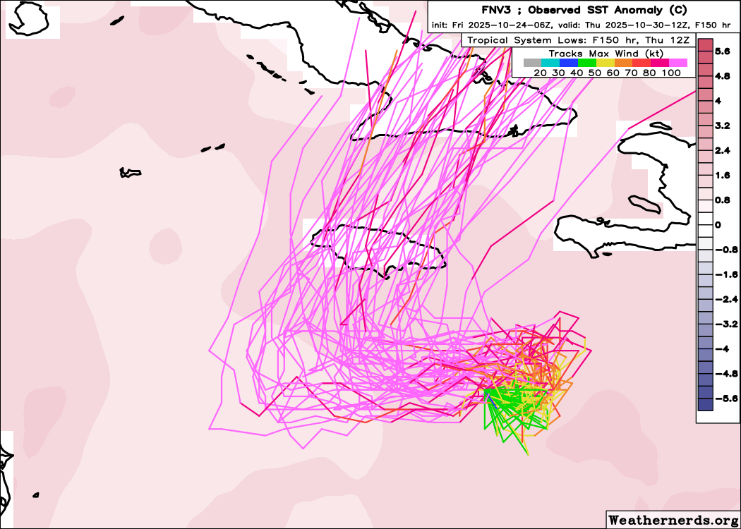
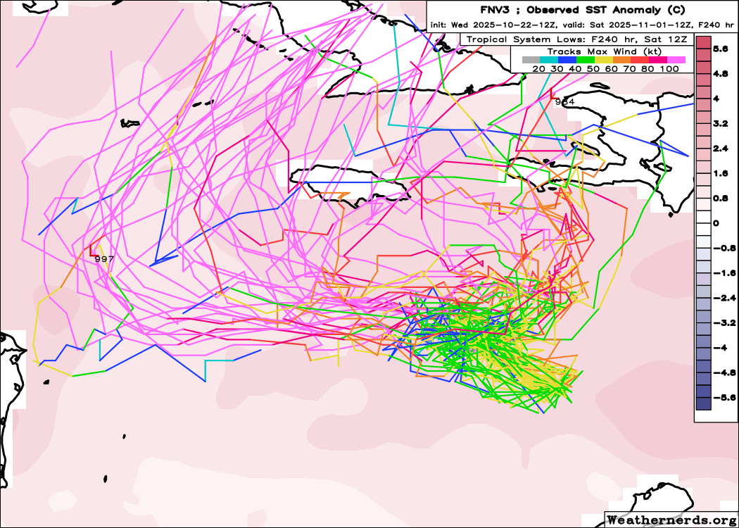
There has been a northeast shift on the models overnight. The Google DeepMind ensembles have come into much better agreement that Melissa will now get pulled northeastward first before it turns west. All of yesterday's tracks that went well southwest of Jamaica are gone. The HAFS models agree with this.
-
Major Hurricane Melissa - 892mb - 185mph Jamaica landfall
hawkeye_wx replied to GaWx's topic in Tropical Headquarters
12z Google model.... more tracks missing Jamaica to the west
-
Major Hurricane Melissa - 892mb - 185mph Jamaica landfall
hawkeye_wx replied to GaWx's topic in Tropical Headquarters
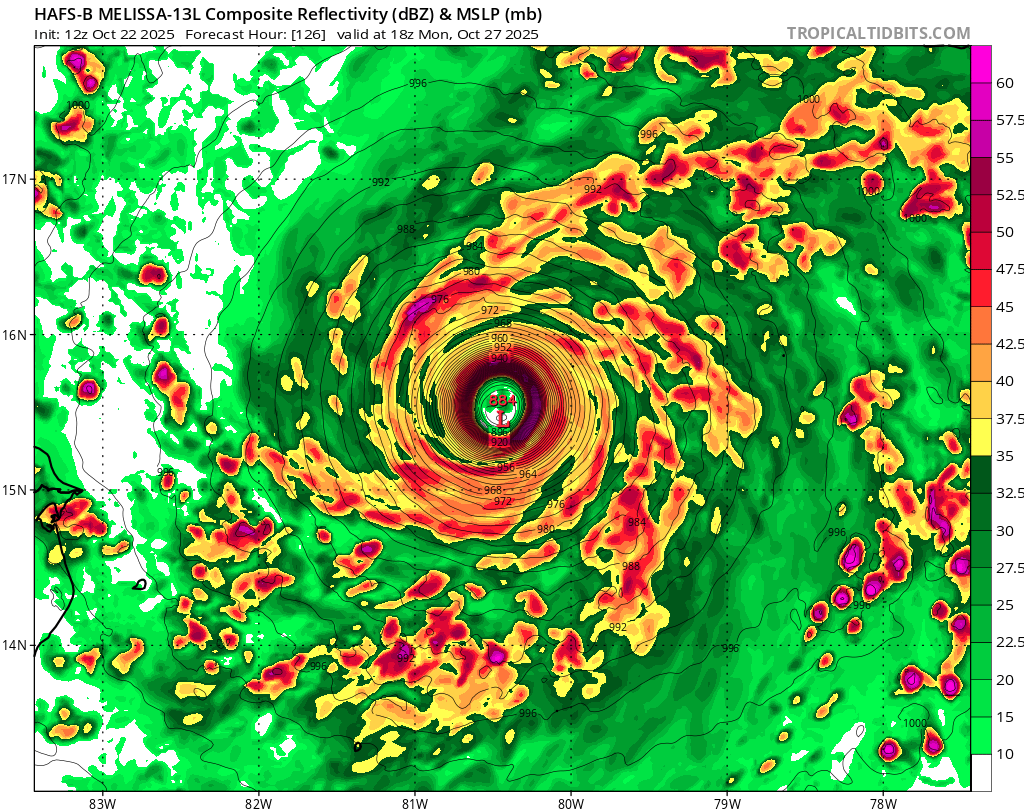
HAFS-B... when it's well sw of Jamaica.
-
Major Hurricane Melissa - 892mb - 185mph Jamaica landfall
hawkeye_wx replied to GaWx's topic in Tropical Headquarters
Latest Euro The new HAFS is going sub-900. -
Major Hurricane Melissa - 892mb - 185mph Jamaica landfall
hawkeye_wx replied to GaWx's topic in Tropical Headquarters
The surface center has once again been spit out toward the west as the convection is unable to hold onto it. -
As often happens, our low temp the next couple mornings has been gradually lowered as it approaches. Now we may get to near freezing. I have to get the rest of my garden cuttings today before plants get zapped.
-
Major Hurricane Melissa - 892mb - 185mph Jamaica landfall
hawkeye_wx replied to GaWx's topic in Tropical Headquarters
Here's the latest Google model. -
Major Hurricane Melissa - 892mb - 185mph Jamaica landfall
hawkeye_wx replied to GaWx's topic in Tropical Headquarters
It appears the surface center was pulled a bit northeast by the overnight convection, but the future track has not changed. The 00z and 06z Euro show what will happen if Melissa can stay far enough sw to get caught under the building ridge this weekend. It would likely explode into a spectacular hurricane.