

buckeye
-
Posts
8,860 -
Joined
Content Type
Profiles
Blogs
Forums
American Weather
Media Demo
Store
Gallery
Everything posted by buckeye
-

Let’s talk winter!! Ohio and surrounding states!! 24'-25'
buckeye replied to buckeye's topic in Lakes/Ohio Valley
Can we get one of these maps to be right…even just once a season? Hell even half right would be nice. (That’s the 360 hr euro snow total for 12z)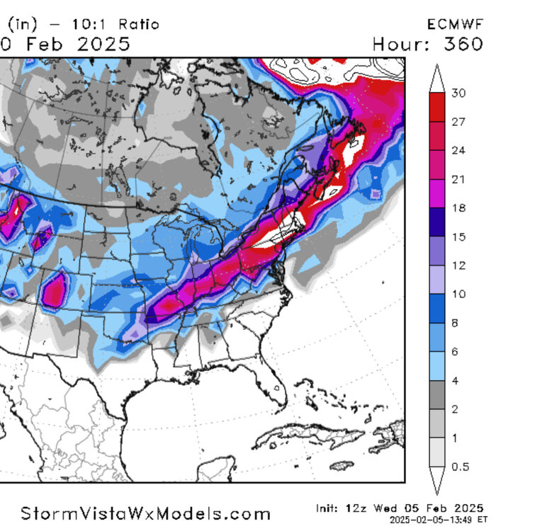
-
Winter 2024-25 Medium/Long Range Discussion
buckeye replied to michsnowfreak's topic in Lakes/Ohio Valley
Our snow totals over the last several years must have crashed our average here in CMH. I didn't realize it, but CMH has not officially recorded a 6" or greater snowfall since 2015. I'm sure mby has touched or exceeded that but still, that's crazy. -
Winter 2024-25 Medium/Long Range Discussion
buckeye replied to michsnowfreak's topic in Lakes/Ohio Valley
yup. On a humorous note, JB finally goes warm for the first time in, (almost ever), and look what happened. I mean, he has to HATE the fact that he never saw places like New Orleans and Pensacola having a record snow year...that's the wheelhouse he claims to OWN. Instead he got pwned. He'll never put out a warm forecast again lol. -
have another drink....
-
it won't
-
Winter 2024-25 Medium/Long Range Discussion
buckeye replied to michsnowfreak's topic in Lakes/Ohio Valley
These medium range snow total maps, whether they're Op or ens, are completely worthless regardless of the model. You would have more accuracy going to a corner psychic shop and asking how much snow, (and that's not sarcasm either). On a broader note, I know some mets get bent when a weenie like myself says it doesn't seem like there's been any improvement to long range forecasting in the last 20 years, (and I know there are technical stats that would prove that wrong), but it's really hard for a weenie like myself to see improvement. It feels exactly like the same crapshoot it was when I started following this stuff in the early 2000's This winter is a perfect example. I didn't see a single long range forecast for this winter made back in fall that came even remotely close to what's unfolded. -
Like my wife. We'll get 2" of snow and she be like, "omg, we must have like 8" out there!" Of course I never correct her, I simply nod my head to reinforce the illusion.
-
Winter 2024-25 Medium/Long Range Discussion
buckeye replied to michsnowfreak's topic in Lakes/Ohio Valley
NO -
Winter 2024-25 Medium/Long Range Discussion
buckeye replied to michsnowfreak's topic in Lakes/Ohio Valley
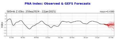
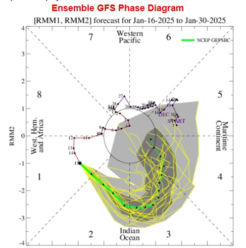
I mean anything is possible, (snowball fights on Bourbon Street for example), but I find it hard to believe we end up with a wall to wall cold January followed by the same for February. I mean we'd be talking about winters of yore. Models always seem to get stuck when a pattern persists...like trying to turnaround an aircraft carrier. I think once the warmth, (or at least milder), pattern actually starts arriving we'll start seeing the fantasy cold shots fading. But I agree the transition will bring some decent storm chances for the sub, probably transitioning to rain for us but better snow chances especially further west. The PNA is still impressively stubborn as hell but trying to break below neutral and the mjo is skirting the warm phases thru the COD as we get into the first week of Feb.
-
Winter 2024-25 Medium/Long Range Discussion
buckeye replied to michsnowfreak's topic in Lakes/Ohio Valley
Trough too far east and always positively tilted, makes it tough to brew up a nor’easter. -
Winter 2024-25 Medium/Long Range Discussion
buckeye replied to michsnowfreak's topic in Lakes/Ohio Valley
have to admit, we've had a snowcover now for quite awhile. Unusual in these parts. See how much rain we get Saturday and then if anything squally develops Sunday ahead of the next plunge. -
Winter 2024-25 Medium/Long Range Discussion
buckeye replied to michsnowfreak's topic in Lakes/Ohio Valley
yea, the early week plunge is still very cold but the models have backed off of the stupid stuff. (edit: ggem still showing -28 in central OH ). I think we start seeing overall moderation in LR, with models backing off of the non-stop arctic plunges out of Canada. For snowlovers, especially in your neck of the woods that's probably a good thing anyways, better chance of lows cutting further west or on top of us. -
Winter 2024-25 Medium/Long Range Discussion
buckeye replied to michsnowfreak's topic in Lakes/Ohio Valley
remember when January was supposed to be warm? -
gfs might have to be the designated driver of the big 3 models. Has us bottoming out around zero next tues-wed while the euro has us -18 and the ggem, (completely sh*t faced) has us -28 which would blow away the all time record low. I would imagine we would have to have a deep snow pack and clear skies for that to even come remotely close. I'll also add that if we get numbers anywhere close to that the good news is the rubberband probably breaks and winter, (for the most part), is essentially over. Think of December 1989 for example. This has that feel except a month later. Relentless cold that started at the beginning of the month, climaxed the third week and disappeared for the rest of the winter. A man can hope at least.
-
Winter 2024-25 Medium/Long Range Discussion
buckeye replied to michsnowfreak's topic in Lakes/Ohio Valley
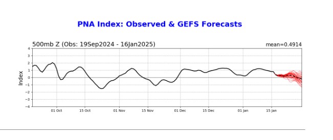
but they don't really say cold either (at least after the next week and a half). Most interesting one to me is the PNA showing it might actually go negative for the first time since beginning of December. Clearly that's been a huge driver of what we've been experiencing.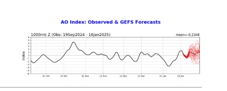
-
Winter 2024-25 Medium/Long Range Discussion
buckeye replied to michsnowfreak's topic in Lakes/Ohio Valley
I get to the end of all these model runs....360hrs out...expecting to see the beginning of the collapse of the cold, (especially looking at where the indices are headed), and yet the cold just keeps reloading in Canada. -
Winter 2024-25 Medium/Long Range Discussion
buckeye replied to michsnowfreak's topic in Lakes/Ohio Valley
God I hope not that long. This is the most depressing weather. Endless days of near/below freezing with no exciting systems to be found. A 4-5" battered snow cover and everything looks dirty and covered in salt dust. First winter where I'm not going any place warm either. Kill me -
Let’s talk winter!! Ohio and surrounding states!! 24'-25'
buckeye replied to buckeye's topic in Lakes/Ohio Valley
btw, the bolded DID end up happening too. Do I know ILN or do I know ILN! -
Winter 2024-25 Medium/Long Range Discussion
buckeye replied to michsnowfreak's topic in Lakes/Ohio Valley
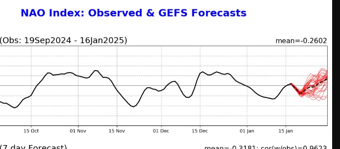
In about 10 days we should see a +nao +ao -pna and the mjo ready to tour the warm phases. #torch-tracking #forch #2012 -
congrats to the cincy and ohio river valley folks! Was really hoping this would have been an i-70 special, but not in the cards. Amazing how the north trend only happens for us when it comes with a warm tongue and a changeover. I picked up about 2.5" just northeast of CMH.
-
Let’s talk winter!! Ohio and surrounding states!! 24'-25'
buckeye replied to buckeye's topic in Lakes/Ohio Valley
that's crazy, I live about 8 miles on a straightline E, NE from there and picked up around 2.5". Hate to say it, but the fcking euro did a good job. GFS scked yet again. Lightest, most powdery snow I've seen in a long time too. This morning I was actually glad we didn't get a crap load....my blower is dead probably from it sitting in my garage for 3 years collecting cobwebs. -
Let’s talk winter!! Ohio and surrounding states!! 24'-25'
buckeye replied to buckeye's topic in Lakes/Ohio Valley
Snowing moderate roads covered -
Let’s talk winter!! Ohio and surrounding states!! 24'-25'
buckeye replied to buckeye's topic in Lakes/Ohio Valley
Flurries finally -
Let’s talk winter!! Ohio and surrounding states!! 24'-25'
buckeye replied to buckeye's topic in Lakes/Ohio Valley
Most of the short term models this morning didn’t have snow coming in until about 7 to 8. That looks like it’ll be about right. I’m actually more concerned with the shield looking kind of ragged andbroken up to our west. -
Let’s talk winter!! Ohio and surrounding states!! 24'-25'
buckeye replied to buckeye's topic in Lakes/Ohio Valley
It’s a game of inches here, literally. I think it’s equal chances that we could get 2 inches or 8 inches. I’ll be watching radar and seeing how many hours of virga we’re gonna get. A common theme that the hrrr and nam have is what looks like the leading edge of snow moving in around 3pm that becomes a head fake and dries out before it gets here and then finally punches thru between 7 and 8. its hard to believe we have 9 more hours to go with this low thick cloud deck combined with the radar, but we’ll see. lets face it, this is how we do snow storms here….always on the edge, either north or south.


