

buckeye
-
Posts
8,861 -
Joined
Content Type
Profiles
Blogs
Forums
American Weather
Media Demo
Store
Gallery
Everything posted by buckeye
-

Let’s talk winter!! Ohio and surrounding states!! 24'-25'
buckeye replied to buckeye's topic in Lakes/Ohio Valley
the weekend has one of my eyebrows in raised position First 'potential' big one worth tracking for the OV in a long time. This type of scenario is what makes tracking fun. Being on the edge 5 days out and hoping for a shift. We've seen too many of these monsters bully north, sometimes to our benefit, (PD2003 and Feb2010), and often to our demise, (Feb 13, 2007). -
Winter 2025-26 Medium/Long Range Discussion
buckeye replied to michsnowfreak's topic in Lakes/Ohio Valley
I lost 52 inches of snow in 6 hours -
Winter 2025-26 Medium/Long Range Discussion
buckeye replied to michsnowfreak's topic in Lakes/Ohio Valley
I was going to post this simply because in all my 30 years of weenie fantasy model watching...this is a first. By far. That being said, even if the gfs has the right idea with a massive overrunning event at that range, the congrats goes to Chicago to Detroit because the gfs is infamously always too far south in the medium/lr. Still, one to save for entertainment value. -
Winter 2025-26 Medium/Long Range Discussion
buckeye replied to michsnowfreak's topic in Lakes/Ohio Valley
record high incoming tomorrow... too bad it has to come with rain though -
unless it's snowing or there is an existing snow pack to preserve for Christmas day, the higher the temp the better. Who the heck would like 30 or 40s and brown over 60's?
-
Winter 2025-26 Medium/Long Range Discussion
buckeye replied to michsnowfreak's topic in Lakes/Ohio Valley
punt'n Jan? -
Winter 2025-26 Medium/Long Range Discussion
buckeye replied to michsnowfreak's topic in Lakes/Ohio Valley
Amen -
from cosgrove: see what I mean about all of that "Phase 8" nonsense that was the talk of the internet?). Remind yourself that for an MJO cold influence in North America, the lead impulse should be between Phases 6 and 1, be very strong, and have at least some connection to the polar westerlies. I always thought phases 3-6 correlated for warmth in our area
-
Winter 2025-26 Medium/Long Range Discussion
buckeye replied to michsnowfreak's topic in Lakes/Ohio Valley
solidly negative pna for the foreseeable. If the mjo heads back into the COD and exits into 4,5 then the only hope will be a herculean block to develop and that may only partially save the easterners. Other than that we might end up going full blown torch. I'm going to Hawaii in Feb. Hmmmm, last time I went to Hawaii was January 2012 #Forch #Morch -
Winter 2025-26 Medium/Long Range Discussion
buckeye replied to michsnowfreak's topic in Lakes/Ohio Valley
I got rid of my snowblower this past summer. I was sick and tired of having to reset the tires on the rims every fall and struggle with getting it to start. For the last several winters I think I used it once or twice, other than that it took up garage space and collected dust. Of course now we've had two snowfalls in the last few weeks that I could have used it already. -
I suspect the winterstorm watch will be dropped to an advisory vs. upgraded to a warning. I was kind of surprised to see them hoist that headline yesterday when there really isn't much model support for a warning criteria snow out of this. We never even had a single nam run that nam'd us either. Looks like a general 2-4" event with maybe a few getting under some heavier banding that could go to 5"+. Looking forward to the thaw! Early December cold/snow almost always ensures a brown Christmas, that's why I wasn't too excited about it happening so early. Of course 1989 was wall to wall frigid the whole month of December and then when the calendar turned to January winter never returned.
-
Let’s talk winter!! Ohio and surrounding states!! 24'-25'
buckeye replied to buckeye's topic in Lakes/Ohio Valley
well this thread was unlucky last year. Maybe this is it's year, typos and all! -
Looks like the airport picked up 5 even. Seems about right, I measured 5.5 on the ground this morning. The only explanation I can come up with for this early season....rare as of late...December snowfall, is the fact that I finally got rid of my snowblower last spring. The crap this morning was way more heavy/wet than I expected too... so of course I was missing that snowblower. In all honesty, this snow was more of a stressor than an enjoyment. We have so much unfinished work to do, we do outdoor lighting. Congrats on your 2-hitter in Dayton. That first one for us was a total dud. Literally 5 minutes of flurries. It's like the snow hit a wall between Dayton and Columbus. Pretty damn impressive for folks in Ohio outside of the lake belt or far nw to get snow on snow in late NOV/ early DEC. I guess the only question is if this early season bout is going to be winter's biggest blow or a taste of things to come.
-
4/2-4/3 Potential Major Severe WX Outbreak
buckeye replied to Geoboy645's topic in Lakes/Ohio Valley
I'm telling you, when we get enhanced or higher it's the kiss of disappointment. CMH is always on the eastern edge of every threat with the timing almost always during the overnight hours. I'm not holding my breath for anything too crazy locally tomorrow / tomorrow night. We shall see. -
For a March snowstorm its lasting effect was solid. It got brutal cold for a couple weeks on its heels and the deep cover stuck around unusually long for the time of year. As far as blizzard criteria, probably about an hour at the end the wind really kicked up and we had white out conditions…. But it didn’t last long.
-
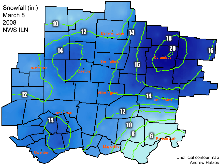
17 years ago and I lived under that 20” bullseye. still paying the price for that one
-
Let’s talk winter!! Ohio and surrounding states!! 24'-25'
buckeye replied to buckeye's topic in Lakes/Ohio Valley
We’re north of 2” here imby already. I think between the rest of the synoptic and maybe some squalls later 3-5” on the ground by night is easily reachable -
Let’s talk winter!! Ohio and surrounding states!! 24'-25'
buckeye replied to buckeye's topic in Lakes/Ohio Valley
Made no sense to me when ILN left their northern tier counties off the wwa. Pretty rough out there right now just like every model was showing yesterday. -
36 hours ago several models were big dog’n Chicago thru Detroit. Now it looks like Chicago won’t see crap and Detroit will get a run of the mill advisory snow. If you can’t trust models 2 days out, wtf is the point? Crazy
-
Let’s talk winter!! Ohio and surrounding states!! 24'-25'
buckeye replied to buckeye's topic in Lakes/Ohio Valley
I literally just saw this on a news feed and it was like 10 days ago. Ganahl was the goat of cmh weather. He moved to Columbus from Iowa during the infamous late 70s winters. I followed and watched him for nearly 45years from when I was in junior high school to becoming a grandpa. He was a huge snow weenie too, loved cold and snow. That’s why it was fun to watch him. RIP Jym, May the blizzards be plentiful in heaven! -
I honestly don't know what would be more embarrassing as a teenage boy.....getting busted at 2am surfing pornhub or getting busted at 2am surfing the 00z euro run.
-
this one is more interesting to me. Highest probability is that it's too far north for mby, but it's a convoluted set up and seems like models are having trouble figuring out where the dominant low eventually forms and tracks. The nao will be neutral, the AO is in the tank, the PNA is positive, and the mjo will be in 8, so I don't think a cut up into the lakes is that likely, but still could come too far north for the i-70 crowd. Also depends on what this weeks storm does. Very rare to see back to back storms take a similar track within 72 hours of each other. Models love to show that kind of porn but reality is usually a different story. At least something to track though.
-
Winter 2024-25 Medium/Long Range Discussion
buckeye replied to michsnowfreak's topic in Lakes/Ohio Valley
don't get too excited, this was a euro op run five days ago. Amazing how quickly 36.7" of snow can disappear. Don't even get me started on the ensembles either. They have been horrible. Consistent runs across the board from ggem, euro, and gfs all showing 20"+ for mby over the 360hr run, (multiple times last week). Incredible how bad they are. I am glad to see our sub finally cashing in further north and west, even though cmh continues to miss south, north, and east. At least it's not the eastcoast getting it this time. -
Winter 2024-25 Medium/Long Range Discussion
buckeye replied to michsnowfreak's topic in Lakes/Ohio Valley
when are them wins com'n? Been a long time....really long time. -
if you combine the small pile in the foreground with the one in the background, your snow will last longer. #respectingthesnow


