

LVblizzard
-
Posts
4,900 -
Joined
-
Last visited
Content Type
Profiles
Blogs
Forums
American Weather
Media Demo
Store
Gallery
Everything posted by LVblizzard
-
E PA/NJ/DE Winter 2025-26 Obs/Discussion
LVblizzard replied to LVblizzard's topic in Philadelphia Region
At this point we want the GEFS to be a miss to the east. 9 times out of 10 the GFS and its ensembles are the last ones to catch on with a storm like this. -
E PA/NJ/DE Winter 2025-26 Obs/Discussion
LVblizzard replied to LVblizzard's topic in Philadelphia Region
And here we go again! I’m not tired yet!!! (Although I’d like this to hold off till later Saturday evening since I have to drive back from State College that day.) -
It’s about to come on board based on hour 108. Possibly in a big way.
-
E PA/NJ/DE Winter 2025-26 Obs/Discussion
LVblizzard replied to LVblizzard's topic in Philadelphia Region
All the other globals have it too but none of them tuck it in like the Euro. Gonna be more sleepless nights ahead looking at these models. -
E PA/NJ/DE Winter 2025-26 Obs/Discussion
LVblizzard replied to LVblizzard's topic in Philadelphia Region
Uhhhhh…what the hell? I did not expect a day 6 HECS on any model tonight. -
January 25-26 Winter Storm Potential
LVblizzard replied to Ralph Wiggum's topic in Philadelphia Region
Ended up with about 11” in Allentown, very impressive given that we lost 7 hours of the storm to sleet. -
January 25-26 Winter Storm Potential
LVblizzard replied to Ralph Wiggum's topic in Philadelphia Region
Main precip is done, just some snizzle left now. Shoveling wasn’t that bad…it really helps that more than 2/3 of our accumulation was fluffy powder. -
January 25-26 Winter Storm Potential
LVblizzard replied to Ralph Wiggum's topic in Philadelphia Region
The HRRR has a warm bias at the surface but a cold bias in the mid levels. Sounds weird but that’s been something I’ve noticed with it over the years. -
January 25-26 Winter Storm Potential
LVblizzard replied to Ralph Wiggum's topic in Philadelphia Region
Mostly snow again for the first time in 3 hours - however looking at radar that pesky mix line is trying to push north again. -
January 25-26 Winter Storm Potential
LVblizzard replied to Ralph Wiggum's topic in Philadelphia Region
We’re in a battleground area here too but it’s about 80/20 sleet when snow does mix in. -
January 25-26 Winter Storm Potential
LVblizzard replied to Ralph Wiggum's topic in Philadelphia Region
Heavy sleet here, few flakes mixed in. The mix line is less than 10 miles north of me. Pain. -
January 25-26 Winter Storm Potential
LVblizzard replied to Ralph Wiggum's topic in Philadelphia Region
Same just to your southwest in Allentown. Feels like we’ll be right on or near the line all day. -
January 25-26 Winter Storm Potential
LVblizzard replied to Ralph Wiggum's topic in Philadelphia Region
Some flakes mixing back in here. Radar shows that line creeping back north again though. May not last long. -
January 25-26 Winter Storm Potential
LVblizzard replied to Ralph Wiggum's topic in Philadelphia Region
Changed to sleet in Allentown. Right on schedule with all the NAM runs from the past couple days. The line does appear to be crashing southeast in central PA…we’ll see if that makes it here and changes us back to snow at some point. -
January 25-26 Winter Storm Potential
LVblizzard replied to Ralph Wiggum's topic in Philadelphia Region
Never underestimate the mid level warm air push in these storms. Even the 2021 blizzard had the sleet line precariously close to the LV when no models showed that. -
January 25-26 Winter Storm Potential
LVblizzard replied to Ralph Wiggum's topic in Philadelphia Region
Heavy snow in Allentown. A little over 5” so far. Looks like we may get to around 10-12” before the sleet gets here. Also a little interesting that the mesos crash the sleet line SE later in the afternoon so it flips back to snow here. -
January 25-26 Winter Storm Potential
LVblizzard replied to Ralph Wiggum's topic in Philadelphia Region
Meanwhile the NAM gets plain rain to Philly. -
January 25-26 Winter Storm Potential
LVblizzard replied to Ralph Wiggum's topic in Philadelphia Region
It’s the NAM/RRFS vs. every other meso. Very intrigued to see how this plays out. I reduced my final call for the Lehigh Valley to 8-14” and I’m very confident in that right now. -
January 25-26 Winter Storm Potential
LVblizzard replied to Ralph Wiggum's topic in Philadelphia Region
Ehhh we got them back in 2021. I think it’s even now. -
January 25-26 Winter Storm Potential
LVblizzard replied to Ralph Wiggum's topic in Philadelphia Region
I will not fall for the HRRR again I will not fall for the HRRR again I will not fall for the HRRR again I will not fall for the HRRR again I will not fall for the HRRR again I will not fall for the HRRR again -
Extreme Cold, Snow & Sleet: SECS 1/24 - 1/26
LVblizzard replied to TriPol's topic in New York City Metro
Hate to say it but it’s pretty useless to look at globals this close to the storm. Mesos and CAMs are more reliable at this range. -
January 25-26 Winter Storm Potential
LVblizzard replied to Ralph Wiggum's topic in Philadelphia Region
NAM and RRFS are on their own with the extreme mid level warm air surge. None of the other globals or mesos agree with pushing sleet to the Poconos. -
January 25-26 Winter Storm Potential
LVblizzard replied to Ralph Wiggum's topic in Philadelphia Region
Euro just came in with an absolute nuke.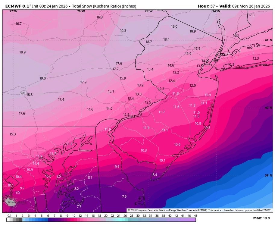
-
Jan 24-26 Weekend Snow and Sleetfest Model Thread Part Tres
LVblizzard replied to H2O's topic in Mid Atlantic
That too…reflectivity is bright and CC shows a clear boundary from roughly Ada to McAlester. Still means the NAM was too warm which has me injecting some hopium. -
Jan 24-26 Weekend Snow and Sleetfest Model Thread Part Tres
LVblizzard replied to H2O's topic in Mid Atlantic
Look at mPING as it relies on actual observations, not the colors on radar maps. It currently has sleet up to Ada, OK, right in line with the Euro and HRRR. It does appear the NAM was too warm at the mid levels, though, as it had sleet up to I-40 where it’s currently all snow.


