

nwohweather
-
Posts
3,818 -
Joined
-
Last visited
Content Type
Profiles
Blogs
Forums
American Weather
Media Demo
Store
Gallery
Everything posted by nwohweather
-
Looks like a breezy but sunny week ahead for us. I could definitely go for a few days in the 40s, cabin fever is starting to hit pretty hard
-
I kinda like this pattern to be honest. As someone who used to live in South Carolina this feels like a true winter. And it hasn't got to the point snowfall wise where travel is paralyzed for days following a massive storm. We put a mini rink in my buddy's backyard and it's been a fun time recently skating outdoors.
-
Noticed this flying over yesterday. Erie looked like the worlds biggest hockey rink out there
-

Winter 2024-25 Medium/Long Range Discussion
nwohweather replied to michsnowfreak's topic in Lakes/Ohio Valley
It has been very odd. Suppression with no nor’easters -
Cool study, appreciate this! Crazy to think in my relatively short lifetime winters have shortened by two weeks
-
Winter 2024-25 Medium/Long Range Discussion
nwohweather replied to michsnowfreak's topic in Lakes/Ohio Valley
I would chock this up as a real winter. Maybe not the snowiest but it's winter alright -
Winter 2024-25 Medium/Long Range Discussion
nwohweather replied to michsnowfreak's topic in Lakes/Ohio Valley
Why do you say that? It looks like the coldest temps in years are possible and we keep getting these 2-3” hits. It’s as winter as you could hope it could be -
Winter 2024-25 Medium/Long Range Discussion
nwohweather replied to michsnowfreak's topic in Lakes/Ohio Valley
I’m looking forward to being stranded in Atlanta next week -
Winter 2024-25 Medium/Long Range Discussion
nwohweather replied to michsnowfreak's topic in Lakes/Ohio Valley
It would be absolutely paralyzing if that were to verify to the region. Maybe I need to move back to Charleston, SC -
Dry air completely winning here in Toledo. Not good news for accumulations, the ground is completely bare here
-
Nice 1-3" here in the Toledo area tomorrow. Bad news with it being during rush hour, good day to work from home
-
Winter 2024-25 Medium/Long Range Discussion
nwohweather replied to michsnowfreak's topic in Lakes/Ohio Valley
I know it's the Northeast but my God look at this in the medium range on the GFS. You'd need front end loaders for Boston & NYC if this verified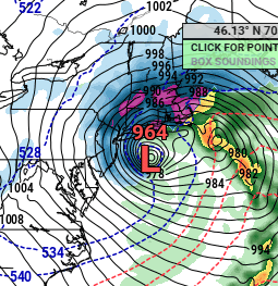
-
Looks like 5-7” across most of Southern IN/OH. Watching radar returns throughout the day it looks like the warm surge was a little more northwards than anticipated. Still, the storm lived up to the hype
-
Thank you! Absolutely ridiculous complaining. I have to give a tip of the hat to the Euro here, it was pretty dang on point days ago in the medium range. One of the more accurately modeled snowstorms I've ever seen. I'm pretty intrigued at that Gulf low next weekend to see what it can bring
-
The lightning on radar coming out of KS/MO is insane
-
Eh it isn’t all sunshine and roses for the Ohio River Valley. With that warm air surging in you’re going to see sleet and freezing rain encroach on those snow totals a bit
-
Pretty impressive this high is this strong with no snowpack aid at the surface really at all. Congrats to Indy, Cincy, Columbus & Pittsburgh. I'm just happy I'll be able to go over to Mt Brighton for some fake snow for the next few weeks
-
Right? It's a panhandle hook that isn't hooking
-
Yup, the low is over Central KY now and not the KY/TN border. It's still hard to think based on climatology that the main swath won't be more north towards the US 30/224 corridor
-
I have to admit I'm shocked. That high pressure is just dominating with little snowpack to aid it
-
What was bad about December? It was a bit chilly but too soggy in the last third. I’d rather see snow over this cold rain but I wouldn’t mind some dry and mild weather. Unfortunately it looks like the dry air will be accompanied by stiff cold
-
As I said on the 30th, the pressure seemed a bit underdone considering all the energy at play here. Compared to yesterday's runs it's a tick more north and a bit stronger. I'd still favor the US 30 to US 20 corridor getting a nice thump of snow with ice concerns along the Ohio River and up into Columbus
-
Definitely needed RainX on that drive haha! It's definitely the soupiest it's been here in months, I think folks forget just how dry our Summer and Fall were. The severe thunderstorm spigot pretty much turned off after April
-
We're still a ways out but I like the odds of this running more along the lines of the Ohio River & not the KY/TN border. That high pressure coming out of the Canadian Prairies means business but I'd feel pretty confident if I lived in between US 20 & US 30 across the Ohio Valley at this time of a 6-10" storm
-
Winter 2024-25 Medium/Long Range Discussion
nwohweather replied to michsnowfreak's topic in Lakes/Ohio Valley
We're still a ways out (and probably need a separate thread for this) but I like the odds of this running more along the lines of the Ohio River & not the KY/TN border. That high pressure coming out of the Canadian Prairies means business but I'd feel pretty confident if I lived in between US 20 & US 30 across the Ohio Valley at this time of a 6-10" storm

