

nwohweather
-
Posts
3,817 -
Joined
-
Last visited
Content Type
Profiles
Blogs
Forums
American Weather
Media Demo
Store
Gallery
Everything posted by nwohweather
-
Very heavy returns around Fort Wayne at the moment. My goodness you don’t see reflectivity like that often in late December
-

Winter 2024-25 Medium/Long Range Discussion
nwohweather replied to michsnowfreak's topic in Lakes/Ohio Valley
And so people should be. Detroit and Toledo aren’t at a very high latitude, a consistent pattern with entrenched cold and a snowpack is the only way you should be fully optimistic. This isn’t exactly Traverse City -
Winter 2024-25 Medium/Long Range Discussion
nwohweather replied to michsnowfreak's topic in Lakes/Ohio Valley
Tomorrow -
Winter 2024-25 Medium/Long Range Discussion
nwohweather replied to michsnowfreak's topic in Lakes/Ohio Valley
It just doesn't look like a good snow maker due to a poor thermal setup. The forecast models all show a thump for Toledo, but the reality is 10:1 ratios are pipe dream with the system having to fight against a very mild air mass currently in place. I wouldn't be shocked to see 1-2" of frozen cement for Toledo and it's eastern suburbs -
Winter 2024-25 Medium/Long Range Discussion
nwohweather replied to michsnowfreak's topic in Lakes/Ohio Valley
One thing I notice on the Euro is that the pressure is likely underdone. Ample warm air being pulled out of the Gulf showing Atlanta at 60 for Hour 180 with ambient temps reaching -20 below in the Dakotas. This thing should be a tad stronger and more tilted. I'd love my chances in Grand Rapids, South Bend & Chicago with this one. -
Agreed. Tough to see a complete lack of cold air with this type of track though, the cold air does look like it's ready to rush the gates though It's a typical track for a low ejecting out of the plains like that however
-
Winter 2024-25 Medium/Long Range Discussion
nwohweather replied to michsnowfreak's topic in Lakes/Ohio Valley
I think Fort Wayne to Detroit stands to get a nice shot there on Tuesday evening -
With some cold air this would be an epic crusher. Brutal to watch
-
12/27-12/29/24 Severe Weather Threat
nwohweather replied to kayman's topic in Central/Western States
Oh boy. Mobile might be in trouble -
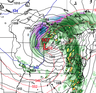
Just absolutely blows me away here. This should be a borderline blizzard, yet hardly any snow on the backside
-
Takes me back to South Carolina a little bit this morning
-
Winter 2024-25 Medium/Long Range Discussion
nwohweather replied to michsnowfreak's topic in Lakes/Ohio Valley
This is not a good sign, sub 1000 mb low with no snow on the backside? Oof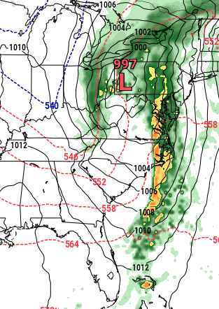
-
Getting weird bursts of snow here. From the looks of it I’d say the rare NW Ohio lake effect is in action
-
Winter 2024-25 Medium/Long Range Discussion
nwohweather replied to michsnowfreak's topic in Lakes/Ohio Valley
I don't agree with that. After today we will be at 9 of 14 days through the month with highs below 40 in Toledo. That's our average temperature in the 1st half of December, I'd say that's a pretty good stretch -
Winter 2024-25 Medium/Long Range Discussion
nwohweather replied to michsnowfreak's topic in Lakes/Ohio Valley
It's pretty wild how entrenched the cold has become as quickly as it has. November was extremely warm and we golfed comfortably on the 17th as the temps were in the low 60s. Fast forward not even a month and we're routinely having highs below freezing and morning lows pushing the single digits. That is quite a drop in just a few weeks, it wouldn't shock me in the least to see a few robust snowstorms roll through this region in January/February -
Winter 2024-25 Medium/Long Range Discussion
nwohweather replied to michsnowfreak's topic in Lakes/Ohio Valley
That’s pretty high up there lol! Our tickets are at the bottom of C deck on the other side. It’s a great place to watch a game and the whole stadium feels like it’s on top of the field. Place should be rocking for a night game, just will be a bit chilly -
Winter 2024-25 Medium/Long Range Discussion
nwohweather replied to michsnowfreak's topic in Lakes/Ohio Valley
I'll be there as well. No you do not want it to be that cold, the horseshoe shape tunnels the wind. Bring the long johns! -
Nice squall right now! My grass is mostly covered, gotta love it
-
Winter 2024-25 Medium/Long Range Discussion
nwohweather replied to michsnowfreak's topic in Lakes/Ohio Valley
No kidding. If you were born in the summer of 2005 you would have seen 3 of the Top 5 snowiest Januaries and 4 of the top 5 snowiest Februaries in Toledo history. That’s quite incredible and shows how violent 21st century winters have been. -
Winter 2024-25 Medium/Long Range Discussion
nwohweather replied to michsnowfreak's topic in Lakes/Ohio Valley
I don't think I'd like to see that again. It was absolutely wild & awesome at times, but our infrastructure really struggled to combat nearly 90" of snow. Toledo & Detroit are not built for that, it made getting around a complete nightmare in the countryside -
Good thing my meeting in Mississauga was moved. Might have gotten a bit dicey around London
-
This is awesome!
-
So ready for this thing to roll in
-
Winter 2024-25 Medium/Long Range Discussion
nwohweather replied to michsnowfreak's topic in Lakes/Ohio Valley
The clipper train in December? Wow I'm shocked -
Winter 2024-25 Medium/Long Range Discussion
nwohweather replied to michsnowfreak's topic in Lakes/Ohio Valley
I'm starting to get rather confident in a 1-3" for Toledo at this time for Thanksgiving. Still wouldn't be shocked to see the hardest snows head more towards I-94 as we get closer to the event


