nwohweather
-
Posts
3,818 -
Joined
-
Last visited
Content Type
Profiles
Blogs
Forums
American Weather
Media Demo
Store
Gallery
Everything posted by nwohweather
-

Winter 2024-25 Medium/Long Range Discussion
nwohweather replied to michsnowfreak's topic in Lakes/Ohio Valley
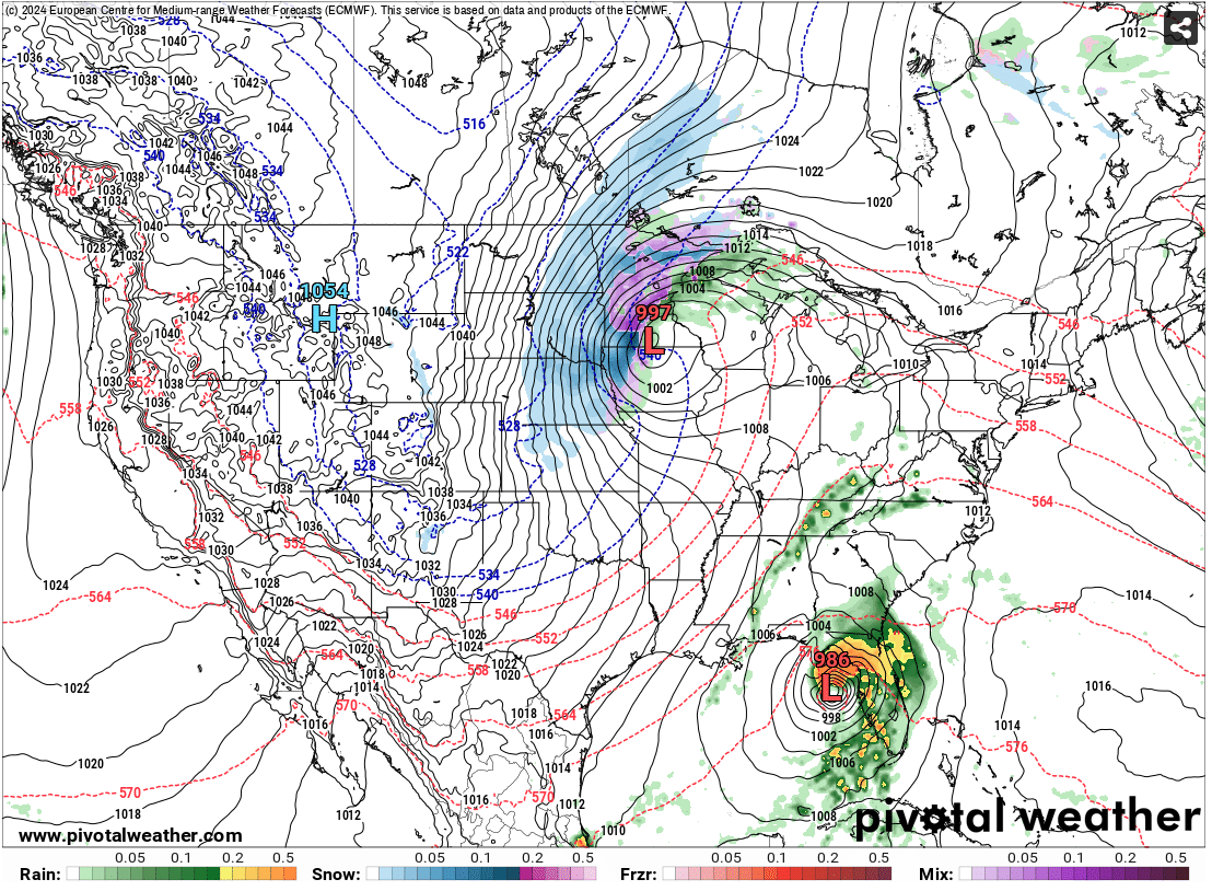
I'm starting to get rather confident in a 1-3" for Toledo at this time for Thanksgiving. Still wouldn't be shocked to see the hardest snows head more towards I-94 as we get closer to the event -
Winter 2024-25 Medium/Long Range Discussion
nwohweather replied to michsnowfreak's topic in Lakes/Ohio Valley
Encouraging to see on the long range solid cold entrenching itself over WCAN -
And are we shocked? November is rarely ever cash in time for this part of the country. I will say it's good to see this pattern putting snow cover down across WCAN, Montana & the Dakotas. I'd be pretty excited if I were in IL/WI/IA based on what the models are showing for Thanksgiving, that is one solid storm for this region. Sure the current solutions show a solid strike for this area but how often does a Panhandle Hook actually roll through Northern Ohio?
-
@OHweather How long did it take to write that AFD? Felt like it was back to the days of your blog with that prose you had going there
-
The Euro maps are just wild. 8-16" for NW Ohio
-
Posting this for posterity

-
November 2024 General Discussion
nwohweather replied to SchaumburgStormer's topic in Lakes/Ohio Valley
That'd be a hell of an effort with this pattern. Looks like we're finally starting to fall off the cliff as highs are routinely getting back into the 50's. As I've said already, I'm team Golf as long as possible so this is very okay with me. -
November 2024 General Discussion
nwohweather replied to SchaumburgStormer's topic in Lakes/Ohio Valley
Much better than the usual snow squalls on the 401 this time of year isn’t it? -
November 2024 General Discussion
nwohweather replied to SchaumburgStormer's topic in Lakes/Ohio Valley
I can confirm ours still is. As long as the temp is in the 50's you're fine, but once it slips below that the agronomy is not very playable. Plus there's the old rule of thumb "It's always colder on the golf course" so 55 in your neighborhood feels a bit warmer than out in the open N-NE breeze we tend to get this time of year. If we can maintain highs in the 60s with some rain through the 17th, I think good Thanksgiving golf will be possible. -
November 2024 General Discussion
nwohweather replied to SchaumburgStormer's topic in Lakes/Ohio Valley
Not quite. Still need grass to able to grow for the greens and temperatures need to be comfortable to a degree -
November 2024 General Discussion
nwohweather replied to SchaumburgStormer's topic in Lakes/Ohio Valley
We’ve got a little bet going on at the house if we’ll be able to golf into December. She buys my round if we do, I’ve got to buy dinner if we cannot. Highs still consistently in the 60s thru week 1 -
Really cannot believe this consistent warmth. If you would've told me during those brutal winters a decade ago that we would be able to golf until Thanksgiving in Toledo by 2024 I wouldn't have believed it.
-
Right? They’re under an Extreme Wind Warning for Pete’s sake
-
These are some very healthy supercells with solid hooks over Alligator Alley.
-
If I'm not mistaken that is the typical air pressure at 1 mile of elevation
-
I'd love to see an interview or video where they show just how violent it was. I can't recall seeing flocks of birds in an official report either
-
This has been one of the most impressive weather days I've ever followed. Absolutely bonkers how much this thing is bombing out
-
It's not often you see a Tropical Storm Warning in Asheville, NC. They're currently under a flood warning at the moment around Gatlinburg anyways, I cannot imagine how bad things are going to get when this roars through.
-
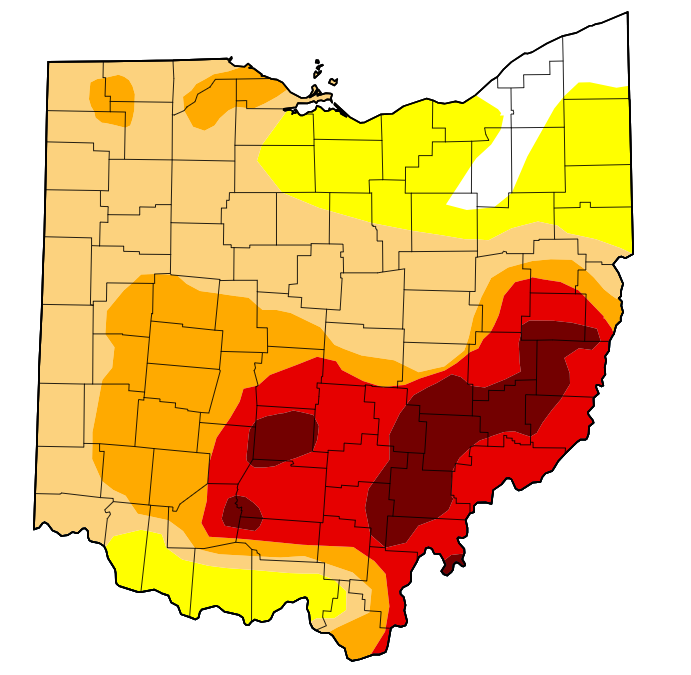
With current severity of the drought I figured it was worth a thread. SE & Central are in a very severe drought at the moment with it growing rapidly in the NW portion as well. From current forecasts as well there is absolutely no rain in sight as well
-
90/74 here currently. Am I back in Charleston, SC or what? Brutal for tonight's HS football
-
2024 Short/Medium Range Severe Weather Discussion
nwohweather replied to Chicago Storm's topic in Lakes/Ohio Valley
Wow, PDS warning in NE Indiana with that cluster!? -
I would wager that is because dews are considerably higher than that time period. For example it's only 90 at my old house in SC at the moment but the dew is 76.
-
Pretty wild to see this level of heat with only 13 hours of daylight. Talk about absolutely pumping the heat in with this ridge. On a positive note, we were on the lake all day today and the cool, dry weather of the past week or so made the water beyond refreshing to swim in today
-
2024 Short/Medium Range Severe Weather Discussion
nwohweather replied to Chicago Storm's topic in Lakes/Ohio Valley
Pretty sure we had touchdowns this morning. What an awful day to have that radar down -
2024 Short/Medium Range Severe Weather Discussion
nwohweather replied to Chicago Storm's topic in Lakes/Ohio Valley
Are we sure there isn't a TOG right now in NW Ohio? I know DTX isn't close here but that's a tad concerning