-
Posts
9,413 -
Joined
-
Last visited
Content Type
Profiles
Blogs
Forums
American Weather
Media Demo
Store
Gallery
Everything posted by LongBeachSurfFreak
-
Green Giant Arb is a pretty hardy plant. Hard to pin down exactly what killed it. The Butterfly bushes are fine, just remove the dead wood and you should get most of it back this season. Essentially a weed.
-
Nice, they just barely make it at our latitude. One late 1800s winter and they would be adios. At Planting Fields arboretum their Camillia collection was in a greenhouse for that reason. Crape Myrtle is another popular example of a southern species now thriving here. The deeper the color the more prone to cold. I have a red that died back to the ground after Feb 15. Grew back and is now tree size again. Seems to be doing fine, just pruned it yesterday.
-
Were they broad leaf evergreens? They are very prone to burning during cold winds. This winter had a ton of that. If they weren’t it was probably stress from the drought last fall.
-
I guess it was more of a delayed rather then denied situation. As far as practical feel for the day, it was more like a day without it, as the afternoon was relatively mild and calm which isn’t what I think of when I think of Ambrose jet type days. Part of what makes weather so fascinating to me, I agreed with you yesterday morning that it had the hallmarks, then I’m sitting in my dads backyard in south wantagh yesterday afternoon, thinking where the F is the wind!!!! It’s a pretty simple phenomenon, heat up the land and drop the pressure compared to the relatively higher pressure over the cold water. Well yesterday had that big time, lots of solar radiation, and below normal mid spring water temps.
-
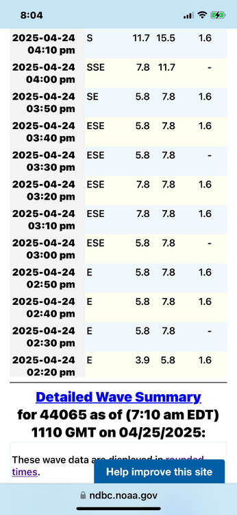
It definitely wasn’t an Ambrose jet event. In fact for most of the afternoon the wind was light east. Data from 44065 ny harbor buoy
-
It’s kind of weirdly calm right now. I’m sitting in the backyard and it’s pretty toasty. Having grown up here, on warm spring days we are usually ripping 30 knots watching low clouds race by overhead by 4pm.
-
I’m in south wantagh right now a few blocks from the bay and no sign of the Ambrose jet. Sometimes it just doesn’t happen.
-
There’s nothing better then walking out of your apartment and being on the beach. If I were wealthy I would have a lb condo, and a mountain house at 2,500’ in the southern greens.
-
Thank you, good to see some maturity for once. We have a climate change thread. I, and others are happy to debate you over there.
-
I’ll just call the Ambrose jet the young vegetable destroyer from now on. The last one shredded my string beans.
-
We have actually been reducing that trend in the US. Overdose deaths in young people is one major factor, but the real catalyst has been life style. Many Americans are sedentary and have awful diets. Now global warming is rapidly accelerating and life expectancy is stagnant or decreasing.
-
Maybe? I’m not sure, that’s before my time. In the 90s movie this cute scientist discovers cold fusion and Val cons her and steals the formula she keeps in her brah. The interesting thing is, the Russian oligarchs try to steal it first because fusion is really bad when you make billions off natural gas. That has to be a major deferent to making fusion a reality. Exon Mobil isn’t about to start paying for fusion research.
-
I could see it happening by 2050, earlier if AI figures it out quicker. The greatest thing about fusion is one of its biggest inhibitors. The movie the Saint with my buddy Val did a good job explaining this all the way back in the 90s. Practically free, unlimited energy is inherently its own worst enemy in a capitalist society.
-
That’s where fusion solves all problems. It’s the most renewable resource possible. If the USA were to devote the time, money and resources to fusion that we did to the Manhattan project or the Apollo missions we could have it in 20 years. It literally changes everything, unlimited clean power allows for unlimited desalination, geo carbon storage and the list goes on and on. One hope is that with advances in AI and quantum computing fusion technology advances faster.
-
I couldn’t agree more. Nuclear fission technology has advanced to a point that it is absolutely the way to go. Unfortunately countries like Germany would rather burn biomass like trees and have shut down their last remaining reactors. Chernobyl just did so much PR damage. The reality is that a repeat is a near zero chance with current tech. The real hope to stopping climate change in my eyes lies with fusion. The problem is it’s always 20 years out from a viability. Some progress has been made, like more energy output then input in the last few years but it’s just not viable yet. We can only hope we get there before it’s too late.
-
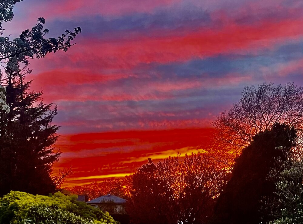
Yeah with my phone. I did increase the contrast and zoomed in. It was an especially vivid sunset.
-
-

2025 Atlantic Hurricane Season
LongBeachSurfFreak replied to BarryStantonGBP's topic in Tropical Headquarters
Exactly what I’m thinking. A big part of why the climate models aren’t predicting huge increases in numbers are do to factors like increase shear and lower lapse rates. But on the high end, the potential increases as OHC increases. More cat 5s but not necessarily many more named storms. -
Hands down the best severe thunderstorm I have ever experienced. I was life guarding at Eisenhower park. It got so dark inside the aquatic center that everyone got out of the pool, indoors! I was able to run outside and watched garbage cans get launched into the building. It was also covered in that green leaf paste you only see with high end winds.
-
Yeah that’s part of it too. Plus plants aren’t fans of chlorine and fluorine.
-
I love watering too, but natural rain is much better for Vegetables in particular. Root systems are much larger horizontally then one would think. So often times just watering around the base, as most people do isn’t the best. Also natural rain over the course of many many hours soaks into the soil more efficiently. I do not know anyone who spends 12 straight hours slowly drizzling water on their plants.
-
Was just out working on my veggie garden and in full sun with no wind it feels hot. Crazy difference from yesterday as far as the “feel” to the day.
-
Lantern flys shouldn’t be killing tree of Heaven as they are their natural hosts. They evolved together in China. Tree of Heaven was planted extensively in urban areas back in the early 1900s because of its extensive resistance to pollution. Much like Norway Maple. Both trees have become extremely invasive. In my opinion all should be removed when possible. This time of year it’s easy to see just how invasive, taking a ride on local highways. All that light green growth you see are the flowers of the Norway maple. In places it outcompetes all native trees and produces pure stands. Terrible for local fauna. Both trees also aren’t adapted to our coastal wind potential. They have weak wood and end up failing.
-

Occasional Thoughts on Climate Change
LongBeachSurfFreak replied to donsutherland1's topic in Climate Change
I agree that the population there is at huge risk. I was just thinking in terms of the monsoon becoming more intense. When temps reach a certain threshold no amount of snowfall will offset the melting. The monsoon is such a complex phenomenon too. Occasionally completely failing locally. If you melt out the glaciers and then the monsoon fails in a given year/year’s that’s when the real trouble starts. -

Occasional Thoughts on Climate Change
LongBeachSurfFreak replied to donsutherland1's topic in Climate Change
This seems rather counterintuitive to me. If one area would benefit from higher precipitation due to higher temps It would be here, as the vast majority is of monsoon origin. These mountains are so high, that they aren’t at risk of temperatures being too high for snowfall until we see something like +5c. It’s going to snow above 18,000’ for a while. Maybe this is a temporary weather phenomenon that evens out over time? Or am I missing something….


