LongBeachSurfFreak
-
Posts
9,404 -
Joined
-
Last visited
Content Type
Profiles
Blogs
Forums
American Weather
Media Demo
Store
Gallery
Everything posted by LongBeachSurfFreak
-
Amazing visibility today and perfect spring weather. Rare to get such such deep blue sky’s during the warm season.
-
I’m at jones beach right now taking my cpr refresher for life guarding and it’s absolutely ripping. Pretty much a perfect example of the Ambrose jet, enhanced with a cold front. Sustained 35 knots gusts 45 knots. One thing about these winds, they are remarkably consistent. As in little variation between sustained and gusts. Ocean is mess of white water and sand is blowing everywhere.
-
That would be fantastic. Build up the soil moisture in our warm season source region. This way maybe we can actually have a severe season this year. With all the wind and jet dynamics maybe we will we can get some EML high wind events. Been a long, long time since we saw one of those classic region wide squall lines that survives all the way to the coast.
-

2025 Atlantic Hurricane Season
LongBeachSurfFreak replied to BarryStantonGBP's topic in Tropical Headquarters
Again, that is only representative of the surface and not the OHC which is what really matters. We have seen a very windy NH winter which had the effect of turning over the surface. It’s not like the year over year temp dropped because the overhead temps were much colder then normal. Increased winds are well predicted by climate change models and are reason for counterintuitive storm number forecasts. -
I was at the beach earlier and it was damn near perfect. Visibility was so good you could see Fire Island from Jones Beach, very rare. Then boom the wind switched from a nice warm land breeze to a fridged sea breeze and I was outta there. Currently perfect in Lynbrook with a slight sea breeze.
-
You can get cold pools at 850 this time of year. Line up strong enough dynamics and you can cool the column down to 32. Obviously elevation helps and that seems to be the case with this storm. The tree damage must have been near complete in areas that had 30”+. Wet snow and broadleaf deciduous trees in full leaf really do not mix.
-
Man that wind sucks today. My veggies keep getting torn up. Almost regretting planting based on temps and disccounting winds.
-
He says allot of ridiculous stuff as you’re aware. His main motivation is allergy’s so anything that potentially reduces pollen is a good thing. I call a spade a spade. The reality is, just like you said, soil moisture in spring should be high. Mud season as they say in NE. Plants are pulling tons of moisture for the leaf out. I guess drought is a subjective thing. it’s allot more then just reservoir numbers. If it were pre Industrial Revolution and the vast majority of us were farmers the past year would be remembered as having been a drought.
-
Not surprisingly it looks like the best of the storm is paralleling the LIE. Pretty meh, here in lynbrook.
-
Just had a super heavy downpour, so heavy that it sounded like hail. Just big rain drops, but it ripped for a few minutes.
-
Yep. I was just working on my veggie garden and what ya know, the soil is still dust 6” down. I really hope this isn’t another annoying dry period starting. Can’t go away for more then a couple days without potentially loosing my veggies. If you want premium plants watering has to be on point. I rent, and my land lords are nice enough to let me have my garden, but I can’t install permanent irrigation.
-
That makes sense, since CT has some decent elevation. You know from you’re poconos house how important elevation is in early and late season events. Also, based on the wind direction, it would be extremely difficult for cold enough air near the coast as water temps in early October are still very warm. Even in the 2011 event the warmer water temps had huge impacts on accumulations. More snow fell at JFK then LGA. And the north shore of the island stayed mainly rain with a fetch off the sound. We had a slushy coating in Long Beach, meanwhile within a mile or two of the sound in say Huntington had zero.
-
I just cut and pasted from 1804 New England hurricane. There was 42” of snow in southern Vermont likely at 2,000’ or more. But temps weren’t even close for us. Way too early in the season even back then. Even calling it a hurricane is highly suspect given the wind directions recorded. A hurricane may have been the nucleus for the storm, but at the very least it was already extra tropical at this latitude.
-
Not even close to snow. The storm, and I say storm, was likely similar to Isias with majority of the energy due to baroclinic fourcing from a powerful trough interaction. While gusts in New York City, where the storm arrived that afternoon, initially blew towards the southeast, they soon shifted towards the north-northwest and coincided with a rapid drop in atmospheric pressure, which bottomed out at 977 mbar(28.87 inHg) by the early afternoon. Though the barometer at the weather station remained at that point for much of the afternoon, the air temperature plummeted rapidly from 55 °F (13 °C) to 42 °F (6 °C) during the same period.[10] A strong westerly circulation encouraged the swift eastward movement of the trough's northern segment, steering the track of the storm northeastward over New England.[11I’m
-
The south shore is often behind areas 10+ miles inland. There is even a noticeable difference from here in North Lynbrook to my dads in South Wantagh.
-
Occasional Thoughts on Climate Change
LongBeachSurfFreak replied to donsutherland1's topic in Climate Change
It’s all relative, in that the water hasn’t cooled, it just hasn’t warmed at the normal seasonal rate. Upwelling from trade winds in the MDR do not change OHC as much however as it’s mixing surface water to relatively shallow depths when compared to inside a hurricane. 10 foot seas in a 25 knot trade wind vs 50 foot seas in 100 knot hurricane winds. If the trades die down during the period of maximum solar insulation in June and July we could easily see a quick reversal. -
Green Giant Arb is a pretty hardy plant. Hard to pin down exactly what killed it. The Butterfly bushes are fine, just remove the dead wood and you should get most of it back this season. Essentially a weed.
-
Nice, they just barely make it at our latitude. One late 1800s winter and they would be adios. At Planting Fields arboretum their Camillia collection was in a greenhouse for that reason. Crape Myrtle is another popular example of a southern species now thriving here. The deeper the color the more prone to cold. I have a red that died back to the ground after Feb 15. Grew back and is now tree size again. Seems to be doing fine, just pruned it yesterday.
-
Were they broad leaf evergreens? They are very prone to burning during cold winds. This winter had a ton of that. If they weren’t it was probably stress from the drought last fall.
-
I guess it was more of a delayed rather then denied situation. As far as practical feel for the day, it was more like a day without it, as the afternoon was relatively mild and calm which isn’t what I think of when I think of Ambrose jet type days. Part of what makes weather so fascinating to me, I agreed with you yesterday morning that it had the hallmarks, then I’m sitting in my dads backyard in south wantagh yesterday afternoon, thinking where the F is the wind!!!! It’s a pretty simple phenomenon, heat up the land and drop the pressure compared to the relatively higher pressure over the cold water. Well yesterday had that big time, lots of solar radiation, and below normal mid spring water temps.
-
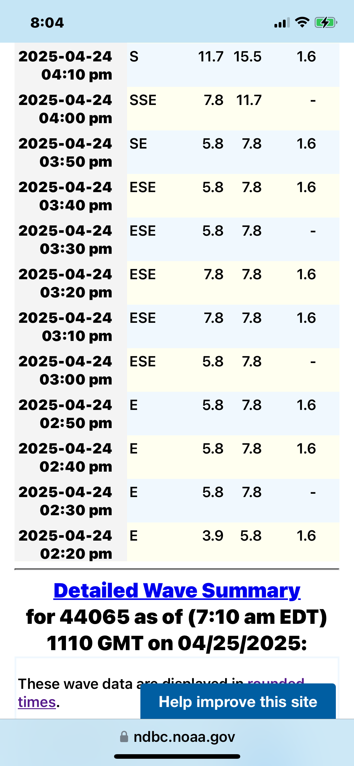
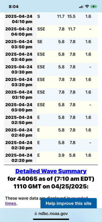
It definitely wasn’t an Ambrose jet event. In fact for most of the afternoon the wind was light east. Data from 44065 ny harbor buoy
-
It’s kind of weirdly calm right now. I’m sitting in the backyard and it’s pretty toasty. Having grown up here, on warm spring days we are usually ripping 30 knots watching low clouds race by overhead by 4pm.
-
I’m in south wantagh right now a few blocks from the bay and no sign of the Ambrose jet. Sometimes it just doesn’t happen.
-
There’s nothing better then walking out of your apartment and being on the beach. If I were wealthy I would have a lb condo, and a mountain house at 2,500’ in the southern greens.
-
Thank you, good to see some maturity for once. We have a climate change thread. I, and others are happy to debate you over there.