LongBeachSurfFreak
-
Posts
9,413 -
Joined
-
Last visited
Content Type
Profiles
Blogs
Forums
American Weather
Media Demo
Store
Gallery
Everything posted by LongBeachSurfFreak
-
It was remarkably dark before here in SW Nassua but has since really lightened up. Missed the rain to the east. Most likely the dry zone today as the convection to the west will have trouble making it into the marine layer.
-
Strange how that area of convection off the jersey shore keeps firing over and over in the same area. It doesn’t seem to move north with the flow either. Must have to do with the Gulf Stream
-
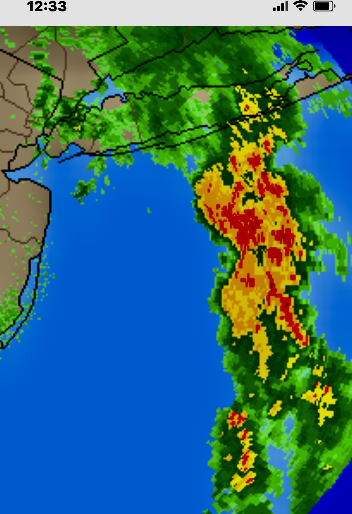
Another moisture plume showing up off the Jersey shore. Looks headed toward western LI this time. Anyone have a map with all the local rain totals for last night? Curious what the east end saw last night other then the AOS and meso stations
-
Right now worst of it looks to be east towards KFOK. Almost has a similar look to the plume from the infamous Islip floods. Though that was a higher dew, higher moisture and higher rates event due to the warmer water temps later in the season.
-
Ummmmm what in the actual F is that on radar south of central Suffolk! It’s obviously a major moisture plume, but wow, if that holds together there will be major flooding out there overnight!!!!
-
Steady moderate rain again in SW Nassua, rare for this to be the jackpot area. But it seems to just want to train here today. I’ll take it, my veggies are pretty stoked.
-
This is a stretch for this particular topic but this is the climate change thread. Personally I’m now hopeful fusion will solve the CO2 crisis. The only thing stopping us from removing CO2 back down to pre industrial levels is a lack of energy. CO2 removal (pumping into the ground being the most effective method) requires a ridiculous amount of energy. With fusion tech and the resulting near limitless energy it’s entirely feasible. AI will likely fast track fusion viability. So a glimmer of light at the end of the tunnel.
-
Actually it would cause an enormous increase in global temperatures from the heat of the fusion reactions. Followed by a global firestorm similar to that after Chicxulub. Many months later when the fires smolder out and dust blocks the sun, then the nuclear winter begins.
-
Rains not dissapointing in SW Nassua. Basically training consistent moderate with a few heavy bursts. Easily over an inch.
-
That’s exactly what I was getting at. They cancled the TOH car show at point lookout Saturday. People drove in from all over, and they were pissed. Getting some pretty steady moderate rain now.
-
It was more about things being needlessly canceled because people use weather apps. We all saw that coming. Its super dark here right now!!!
-
About to rip on the island. This batch coming in from the south means business. Should drop a quick inch. Rates in these setups often exceed radar depiction.
-
About .35” in SW Nassua. Finally got through the trees when we had decent rates. I hope this isn’t another warm season tracking rain like snow accumulations.
-
While both of those are garunteed to happen at some point, Yellowstone could be hundreds of thousands of years and a extinction level meteor impact millions of years.
-
See here is the thing, you love 100+ degree temps. The vast majority of people would find that crazy.
-
Strange, low 60s and sheet drizzle SW Nassua. Hasn’t even soaked through the trees.
-
Hour 55 sure. We all get a soaking tomorrow night.
-
Yeah the trajectory looks west. Likely just some sheet drizzle in the marine layer east of the city. We have seen this show before.
-
Not a drop on the south shore of the island. But such is to be expected for those in the know. Hoping we finally get some strataform rains and some elevated convection later today.
-
Ok cool. I figured I was missing something.
-
Based on the tree damage in the photo looks like straight line winds. I’m just going off the fact that there isn’t any twisting and the trees all broke fairly low down and fell the same direction. Usually with ef0 damage you will see branches and tops broken off higher up. I’m not discounting your personal knowledge experience and having been there by the way. Just one photo.
-
Yeah deer resistant plants aren’t really my area of expertise. I just assume they eat almost anything. They are making their way back into the north shore of Nassua. But more of a scattered population. I’m sure they make it pretty deep into the Bronx too. Van Cortland park is big enough to support a pretty large permanent population.
-
Nice shots Don! Tulips have the most incredible variety as they have been grown for ornamental value for so long. The major issue with Tulips are squirrels. They love to eat the bulbs. I’m sure the NYBG either replants bulbs yearly or somehow keeps the squirrels away. Daffodils are great to mix in, in a less formal garden as they are toxic and squirrels will avoid the area.
-
Aaaaaaaaaaaand poof! The cell off Cnj that caused those automatic weather apps to send an alert that it was going to start raining in an hour, is gone. So much stuff canceled today, when pretty much any of us who have been following the local weather for a while knew it wasn’t going to happen.