nchighcountrywx
-
Posts
2,669 -
Joined
-
Last visited
Content Type
Profiles
Blogs
Forums
American Weather
Media Demo
Store
Gallery
Everything posted by nchighcountrywx
-
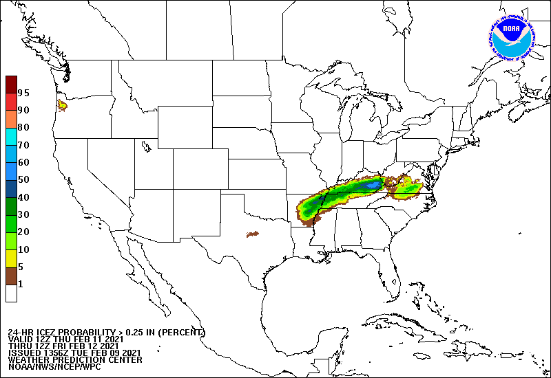
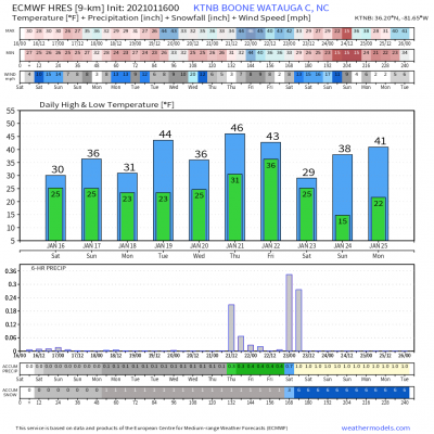
Avery-Caldwell Mountains-Burke Mountains- Including the cities of Ingalls, Banner Elk, Newland, and Jonas Ridge 249 PM EST Thu Feb 11 2021 ...WINTER WEATHER ADVISORY IN EFFECT FROM MIDNIGHT TONIGHT TO NOON EST FRIDAY... * WHAT...Freezing rain expected. Total ice accumulations of a light glaze. * WHERE...Avery, Caldwell Mountains and Burke Mountains Counties. * WHEN...From midnight tonight to noon EST Friday.
-
Full WPC guidance here https://origin.wpc.ncep.noaa.gov/pwpf/wwd_accum_probs.php?ftype=probabilities&fpd=24&ptype=icez
-
2020/2021 Fall/Winter Mountain thread
nchighcountrywx replied to Met1985's topic in Southeastern States
Epic winter still in progress this year. -
2020/2021 Fall/Winter Mountain thread
nchighcountrywx replied to Met1985's topic in Southeastern States
GSP 6 to 10 inches upslope snow inbound in mountains with higher amounts over 4500 -
2020/2021 Fall/Winter Mountain thread
nchighcountrywx replied to Met1985's topic in Southeastern States
Blue Ridge Propane does a good job but I don’t think they cover your area -
2020/2021 Fall/Winter Mountain thread
nchighcountrywx replied to Met1985's topic in Southeastern States
Sperry Piltz Ice Accumulation Index http://www.usawx.com/icestormindex.htm -
2020/2021 Fall/Winter Mountain thread
nchighcountrywx replied to Met1985's topic in Southeastern States
https://www.hcpress.com/news/the-first-30-days-of-winter-have-felt-like-well-winter-with-snow-still-everywhere.html?fbclid=IwAR3jQk3bOxgwtaaNs0X9tPOIcIGhVcAdXW00UN5s52ZGduMyKMgEIzUpQVc -
You are spot on On Friday the MJO gave signs the implied pattern was going to unravel Yes it is very disappointing however it has been a great run of winter since 11/29 in western NC with 41 days of general snow cover above 4500’ and already 60” this season in places. Far better than last year
-
BAMWX updated video. Excellent work.
-
Our good winter for snow in the NC High country continues. Has been a generally good run for 48 days since 11/29 above 4500’
-
2020/2021 Fall/Winter Mountain thread
nchighcountrywx replied to Met1985's topic in Southeastern States
Snow event on target for today. Enjoy as it may be the last good snow weekend for a while Great weekend for back country outdoorsman AFD NEAR TERM /THROUGH TONIGHT/ AS OF 330 AM...A LARGE STACKED LOW WILL SLOWLY DRIFT EAST ACROSS THE OHIO VALLEY TODAY, BRINGING STEEP MID-LVL LAPSE RATES AND SOME MOISTURE INTO THE FORECAST AREA. WESTERLY LOW-LEVEL FLOW WILL PRODUCE PERIODS OF SCATTERED TO NUMEROUS SNOW SHOWERS ALONG THE TN BORDER, WITH ELEVATIONS ABOVE 3500 FT GETTING GENERALLY 1-3 INCHES THRU THIS EVENING. THE CURRENT WINTER WEATHER ADVISORY LOOKS GOOD FOR TODAY INTO TONIGHT.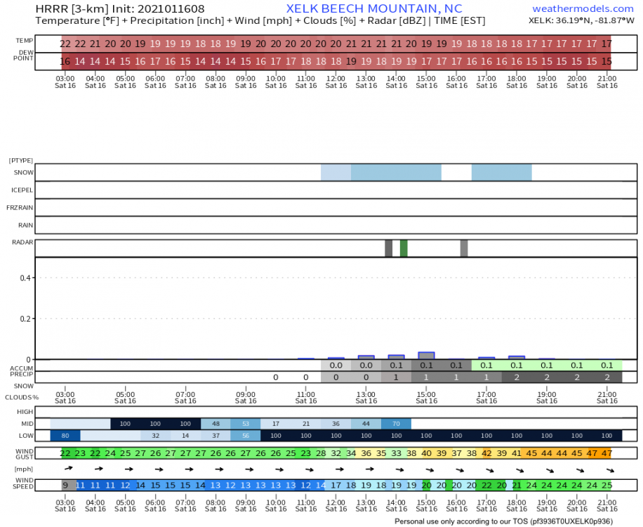
-
2020/2021 Fall/Winter Mountain thread
nchighcountrywx replied to Met1985's topic in Southeastern States
Go with the steel pipe. I have one mounted roof level at 34’ and a second one in the back area at 10’ -
2020/2021 Fall/Winter Mountain thread
nchighcountrywx replied to Met1985's topic in Southeastern States
Beech Mountain
-
2020/2021 Fall/Winter Mountain thread
nchighcountrywx replied to Met1985's topic in Southeastern States
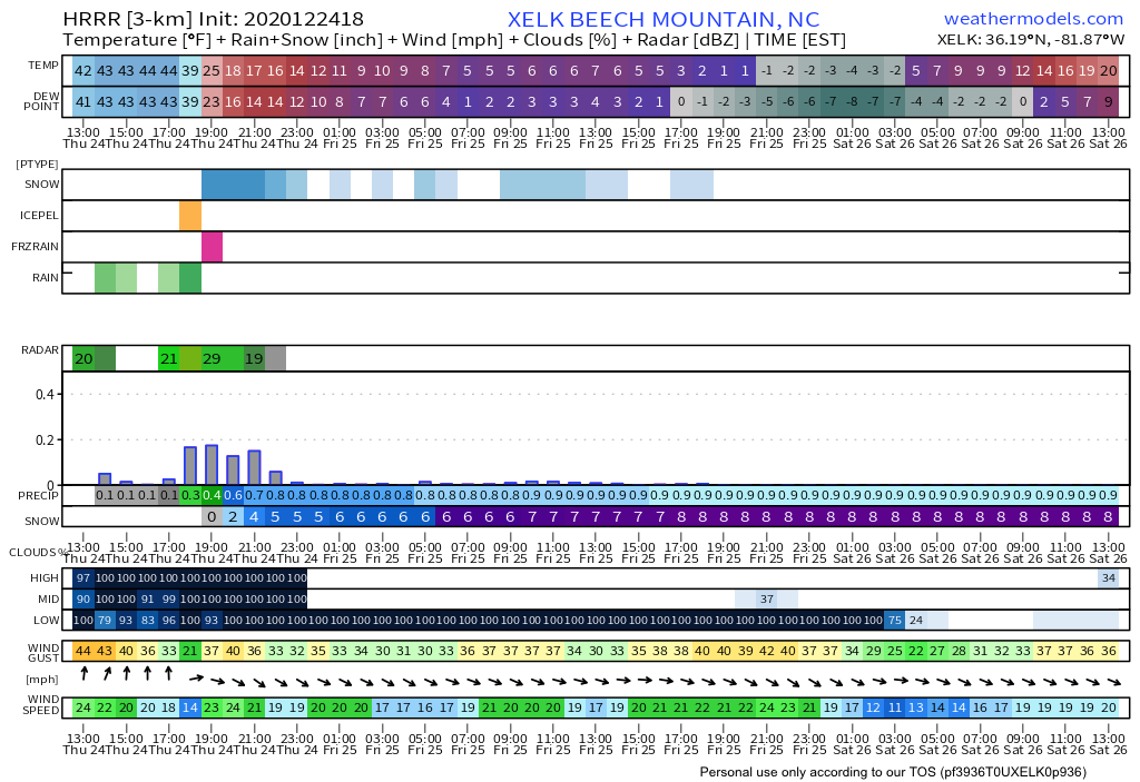
HEAVY SNOW POSSIBLE THURSDAY EVENING OVER PARTS OF THE NORTHERN MOUNTAINS OF NORTH CAROLINA ALONG THE TENNESSEE BORDER... NCZ033-048>050-240100- /O.NEW.KGSP.WS.A.0002.201224T2100Z-201225T1100Z/ Avery-Madison-Yancey-Mitchell- Including the cities of Ingalls, Banner Elk, Newland, Faust, Mars Hill, Marshall, Walnut, Allenstand, Hot Springs, Luck, Swiss, Burnsville, Celo, Micaville, Ramseytown, Busick, Spruce Pine, and Poplar 1150 AM EST Wed Dec 23 2020 ...WINTER STORM WATCH IN EFFECT FROM THURSDAY AFTERNOON THROUGH LATE THURSDAY NIGHT... * WHAT...Heavy snow possible. Total snow accumulations of 2 to 5 inches possible. Winds could gust as high as 40 mph. * WHERE...Avery, Madison, Yancey and Mitchell Counties. * WHEN...From Thursday afternoon through late Thursday night. -
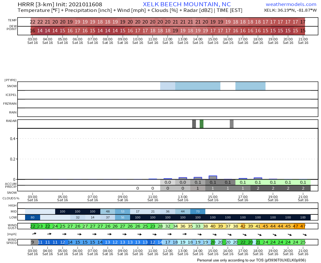
2020/2021 Fall/Winter Mountain thread
nchighcountrywx replied to Met1985's topic in Southeastern States
HRRR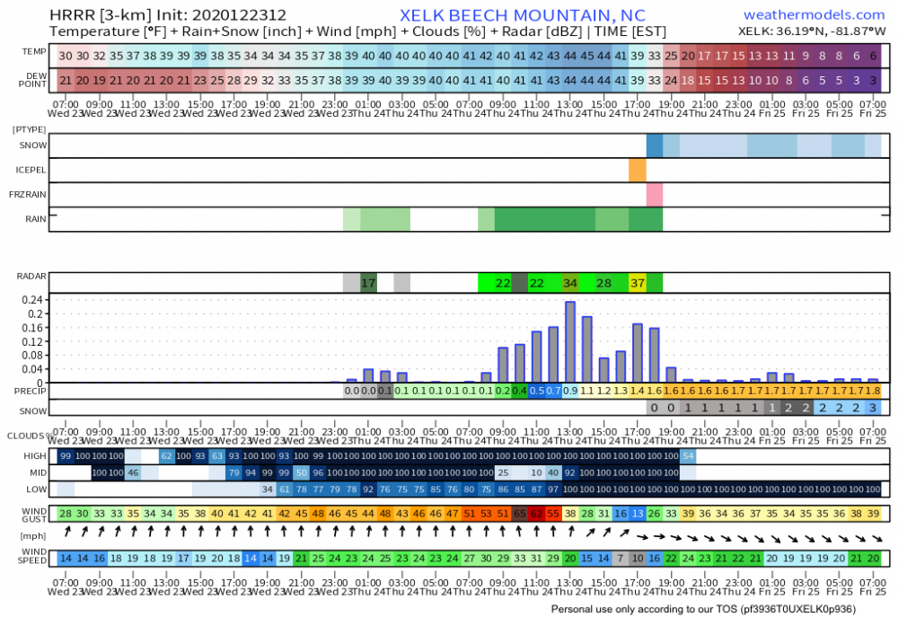
-
Ice Time? Dec. 16ish Possible CAD Event
nchighcountrywx replied to Tar Heel Snow's topic in Southeastern States
Not feeling this one We were blessed to have the terrific snow in the high elevations the week after Thanksgiving. -
2020/2021 Fall/Winter Mountain thread
nchighcountrywx replied to Met1985's topic in Southeastern States
Ensembles for next week
-
Fellows: We need urgent prayer for Big Frosty (Rodney). He and his wife both contracted COVID about a month ago and he cleared it after a brief hospitalization and was back at work. Unfortunately, the side effects came back last night with blood clots in the lung and pneumonia. He is hospitalized today but not in ICU. Rodney asked that he will appreciate prayer from everyone for a quick recovery. There is no one else that has a higher level of interest in winter weather and knows his local climatology the way Big Frosty does. To all, thank you for taking the time to be prayer warriors. It is gratefully appreciated. Thank you.
-
Joe Bastardi put out an extremely warm initial call map for the East today +3 everywhere in East and 75% of normal snowfall.
-
Our friend and board contributor Big Frosty from the Foothills of NC is having back spinal surgery this morning to have spacers and a rod put in to help lessen back pain associated with nerve compression. Please cover him in prayer this morning for a successful surgery with no complications.
-
December 8-10, 2018 Winter Storm
nchighcountrywx replied to Orangeburgwx's topic in Southeastern States
NAM output courtesy of Wright Weather Snow Sleet Freezing Rain -
December 8-10, 2018 Winter Storm
nchighcountrywx replied to Orangeburgwx's topic in Southeastern States
HRRR for Sunday 4am -
December 8-10, 2018 Winter Storm
nchighcountrywx replied to Orangeburgwx's topic in Southeastern States
Updated WPC Guidance and Discussion https://www.wpc.ncep.noaa.gov/discussions/hpcdiscussions.php?disc=qpfhsd -
December 8-10, 2018 Winter Storm
nchighcountrywx replied to Orangeburgwx's topic in Southeastern States
1AM Sunday -
December 8-10, 2018 Winter Storm
nchighcountrywx replied to Orangeburgwx's topic in Southeastern States
New WPC Probabilities