nchighcountrywx
-
Posts
2,669 -
Joined
-
Last visited
Content Type
Profiles
Blogs
Forums
American Weather
Media Demo
Store
Gallery
Everything posted by nchighcountrywx
-
2024-2025 Fall/Winter Mountain Thread
nchighcountrywx replied to Buckethead's topic in Southeastern States
-
2024-2025 Fall/Winter Mountain Thread
nchighcountrywx replied to Buckethead's topic in Southeastern States
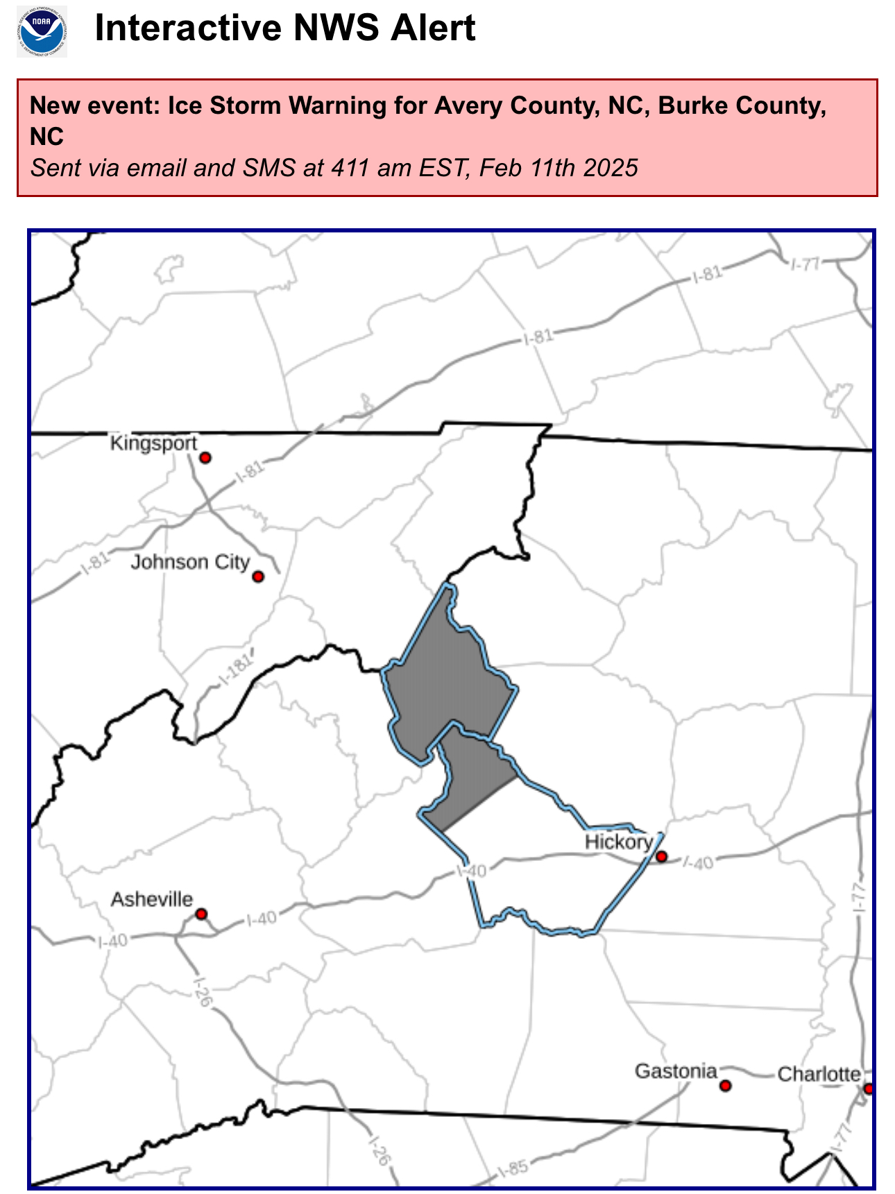
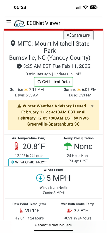
Ice Storm Warning https://inws.ncep.noaa.gov/a/a.php?i=109304611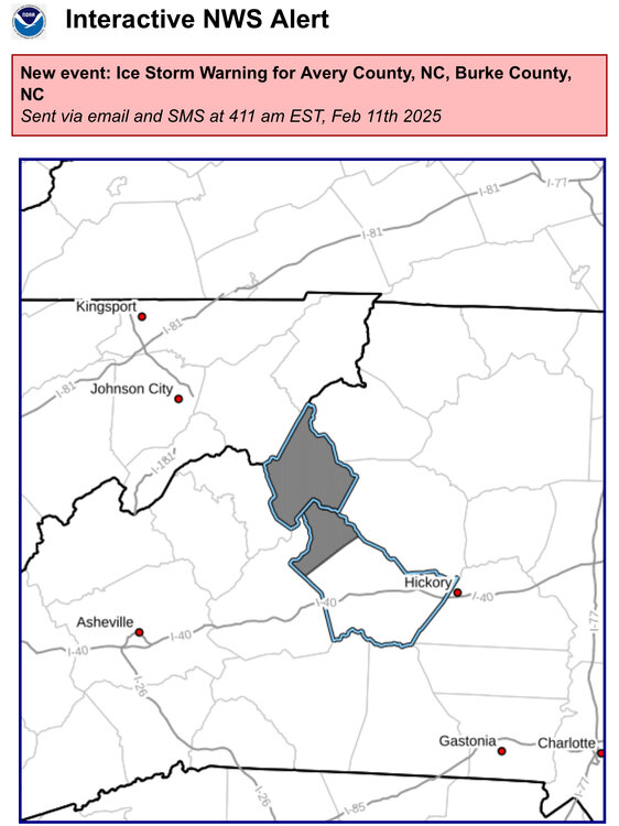
-
2024-2025 Fall/Winter Mountain Thread
nchighcountrywx replied to Buckethead's topic in Southeastern States
All in one place images: https://www.weather.gov/gsp/winter#tab-6 -
2024-2025 Fall/Winter Mountain Thread
nchighcountrywx replied to Buckethead's topic in Southeastern States
Courtesy of Raysweather A potent low forms in Oklahoma Sunday. It will be in Kentucky Monday before transferring energy to a coastal low late Monday. Temperatures look tricky, but we look "just out of the money." Overrunning moisture may arrive in time to produce a period of mixed precipitation (light rain and snow) on Sunday afternoon. The heaviest precipitation comes Sunday night. Dynamic coolling at the beginning of the heaviest rain may cool the atmosphere to give us a mix of rain and snow, but temperatures will warm aloft producing just rain later Sunday night into early Monday. A front moves through Monday, and much colder air arrives. Precipitation changes to snow showers and flurries, ending Monday evening. Like so many before, this NW flow event will favor west over east for light accumulations of snow. Tuesday will be cold with more sun. But the coldest air of the season may accompany a secondary front arriving late Wednesday. Again a few snow showers or flurries may follow the front Wednesday night. Cold weather will be with us for the first two weeks of January, but currently, there's no real candidate for a significant snow. -
2024-2025 Fall/Winter Mountain Thread
nchighcountrywx replied to Buckethead's topic in Southeastern States
Thoughts? I have concerns about the null phase in January
-
2024-2025 Fall/Winter Mountain Thread
nchighcountrywx replied to Buckethead's topic in Southeastern States
A Thanksgiving Day Prayer O God of Whose mercies there is no number, and of Whose goodness the treasure is infinite: we render thanks to Thy most gracious Majesty for the gifts Thou hast bestowed upon us, always beseeching Thy clemency; that as Thou grantest the petitions of them that ask Thee, Thou wilt prepare them for the greater rewards that still await them. Taken from the Collect of the Votive Mass of Thanksgiving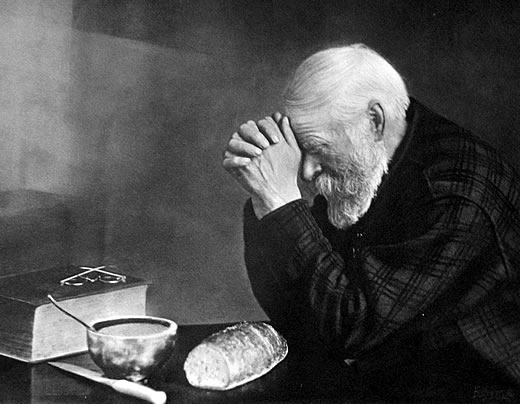
-
2024-2025 Fall/Winter Mountain Thread
nchighcountrywx replied to Buckethead's topic in Southeastern States
I noticed Raysweather has posted his winter snowfall predicitons. About half of normal.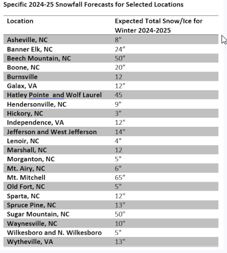
-
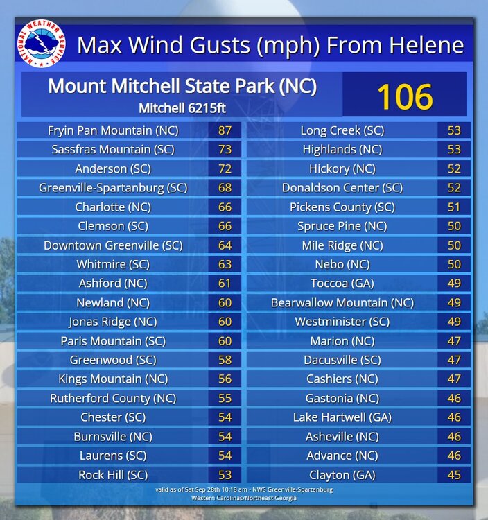
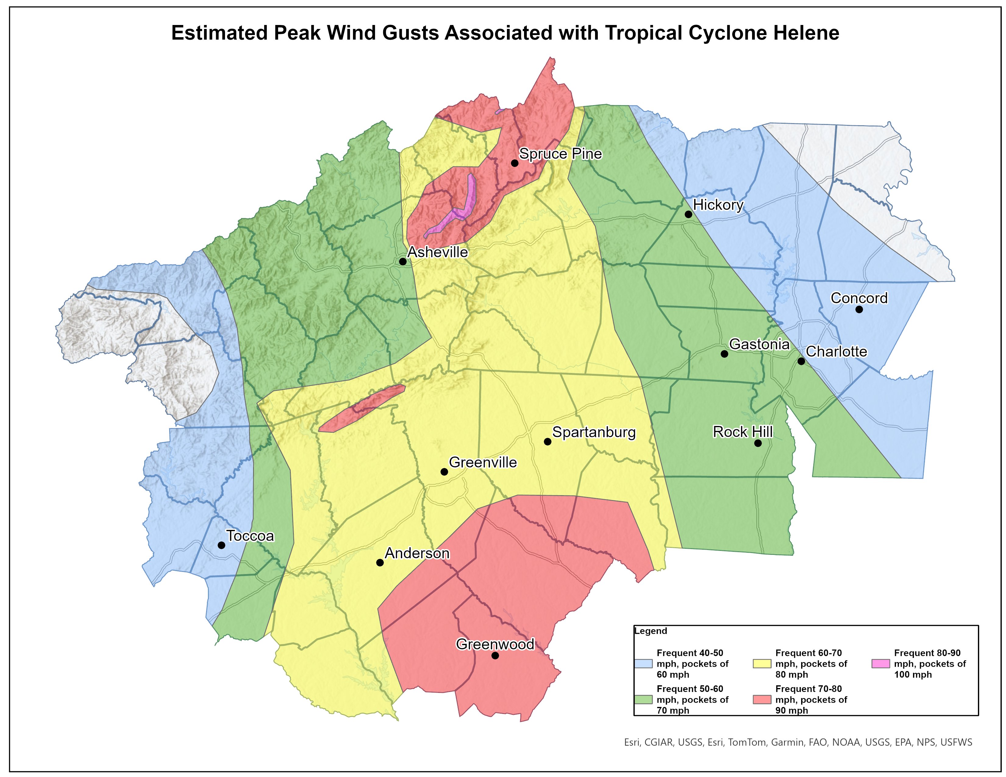
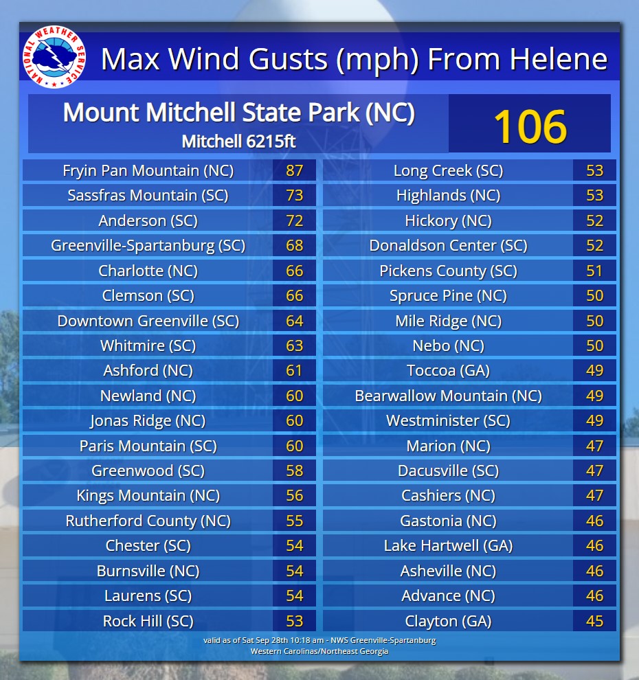
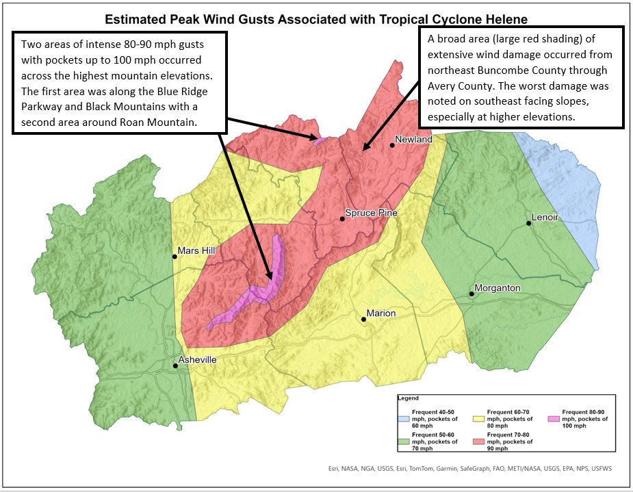
Final wind study from NWS

-
2024-2025 Fall/Winter Mountain Thread
nchighcountrywx replied to Buckethead's topic in Southeastern States
Final wind study from NWS

-
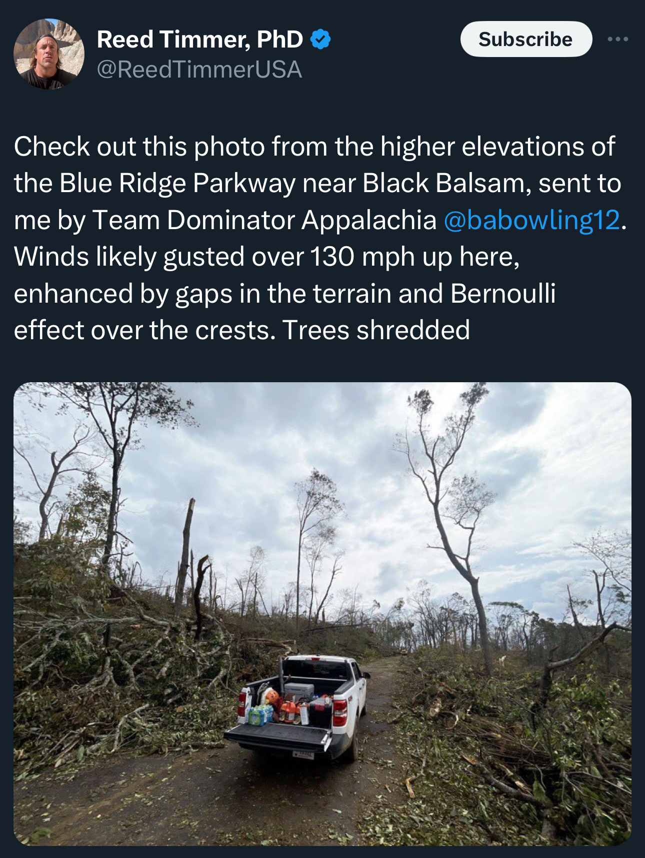
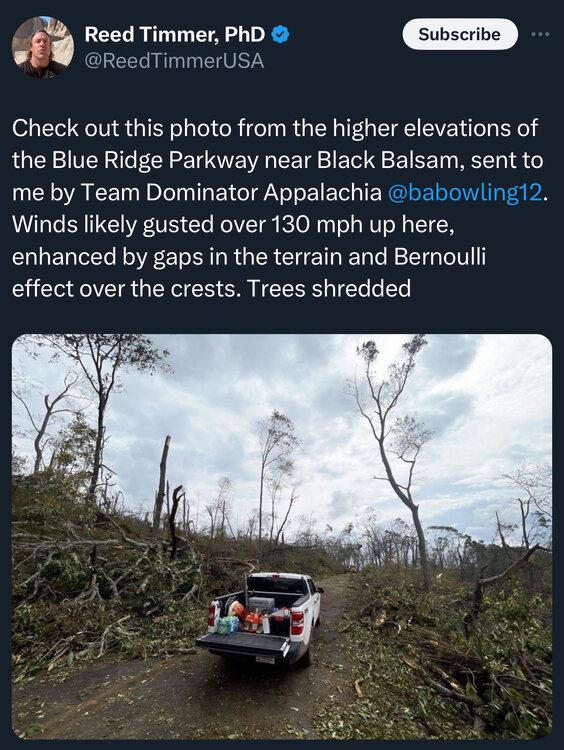
Blue Ridge Parkway https://x.com/matt_vanswol/status/1845913514814140427?s=61&t=NYGZiFKABV_lXD3TjUs_mw
-
2024-2025 Fall/Winter Mountain Thread
nchighcountrywx replied to Buckethead's topic in Southeastern States
Blue Ridge Parkway from the air https://x.com/matt_vanswol/status/1845913514814140427?s=61&t=NYGZiFKABV_lXD3TjUs_mw -
2024-2025 Fall/Winter Mountain Thread
nchighcountrywx replied to Buckethead's topic in Southeastern States
https://x.com/_thelast_stand_/status/1844581410109018307?s=61&t=NYGZiFKABV_lXD3TjUs_mw elk Mountain -
https://x.com/_thelast_stand_/status/1844581410109018307?s=61&t=NYGZiFKABV_lXD3TjUs_mw
-
2024-2025 Fall/Winter Mountain Thread
nchighcountrywx replied to Buckethead's topic in Southeastern States
We ready... Thanks Timm -
Newland NC Click on Watch on Youtube to load the video, it is protected to not show on other sites.
-
2024-2025 Fall/Winter Mountain Thread
nchighcountrywx replied to Buckethead's topic in Southeastern States
Newland NC Click on Watch on Youtube to load the video, it is protected to not show on other sites. -
2024-2025 Fall/Winter Mountain Thread
nchighcountrywx replied to Buckethead's topic in Southeastern States
https://x.com/bakerperry1/status/1842718967485304915?s=46&t=RIRJbzpoDWGSln8sLz6H5A -
2024-2025 Fall/Winter Mountain Thread
nchighcountrywx replied to Buckethead's topic in Southeastern States
-

-
-
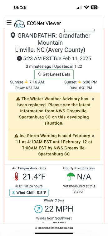
That’s super. There is great cross country skiing up the road from Atria Lane. I know Jim and he’s a fine fellow. The home at the top is a sight to behold. If he still has it on the market you may can view the listing Let me know how Roaring Creek made out in the flood. There is also a RAWS weather station in a meadow up gravel road from Atria
-
2024-2025 Fall/Winter Mountain Thread
nchighcountrywx replied to Buckethead's topic in Southeastern States

-
-
I have an excel spreadsheet of the minute by minute readings if you need it
-
2024-2025 Fall/Winter Mountain Thread
nchighcountrywx replied to Buckethead's topic in Southeastern States