nchighcountrywx
-
Posts
2,669 -
Joined
-
Last visited
Content Type
Profiles
Blogs
Forums
American Weather
Media Demo
Store
Gallery
Everything posted by nchighcountrywx
-
2022-2023 Fall/Winter Mountains Thread
nchighcountrywx replied to BlueRidgeFolklore's topic in Southeastern States
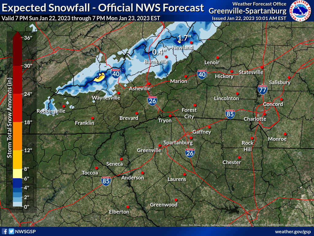
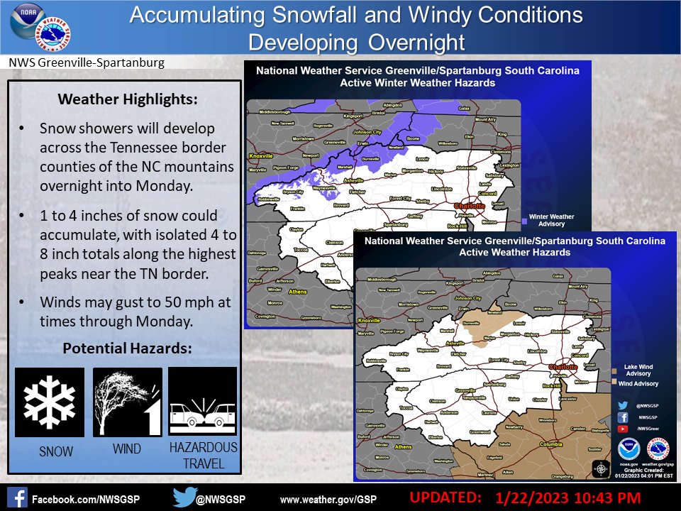
GSP AFD: THERE IS A PRECIP-TYPE WRINKLE AT THE HIGHEST ELEVATIONS THAT DEVELOPS BY THURSDAY AFTERNOON, PERHAPS THE RESULT OF DYNAMIC COOLING, WHEREBY A NEARLY ISOTHERMAL LAYER IS SEEN ON FCST SOUNDINGS ABOVE 5000 FEET OR SO. IT WOULDN'T TAKE MUCH TO BRING THE SNOW LEVEL DOWN TO WHERE WE COULD SEE A CHANGEOVER TO A HEAVY WET SNOW ABOVE 5K FEET. SUSPECT IT WILL BE SNOW AT THE SUMMIT OF MT MITCHELL BY THE END OF THE DAYTIME PERIOD. ELSEWHERE, THE EXTENSIVE CLOUDS, PRECIP, AND COOL AIR MASS WILL KEEP HIGH TEMPS IN THE MID/UPPER 40S. -
2022-2023 Fall/Winter Mountains Thread
nchighcountrywx replied to BlueRidgeFolklore's topic in Southeastern States
I would be interested in doing that sometime. I am always looking for new access points to trailheads for the the Appalachian Trail without trespassing on someone else's private land. The OnX OffRoad app does a good job of showing who owns which land. I have never visited the bald in your area. I would bring along my Garmin Montana -
2022-2023 Fall/Winter Mountains Thread
nchighcountrywx replied to BlueRidgeFolklore's topic in Southeastern States
-
2022-2023 Fall/Winter Mountains Thread
nchighcountrywx replied to BlueRidgeFolklore's topic in Southeastern States

-
2022-2023 Fall/Winter Mountains Thread
nchighcountrywx replied to BlueRidgeFolklore's topic in Southeastern States
-
2022-2023 Fall/Winter Mountains Thread
nchighcountrywx replied to BlueRidgeFolklore's topic in Southeastern States
https://stream.resortcams.com/live/reddenrealty.stream/playlist.m3u8 -
2022-2023 Fall/Winter Mountains Thread
nchighcountrywx replied to BlueRidgeFolklore's topic in Southeastern States
Updated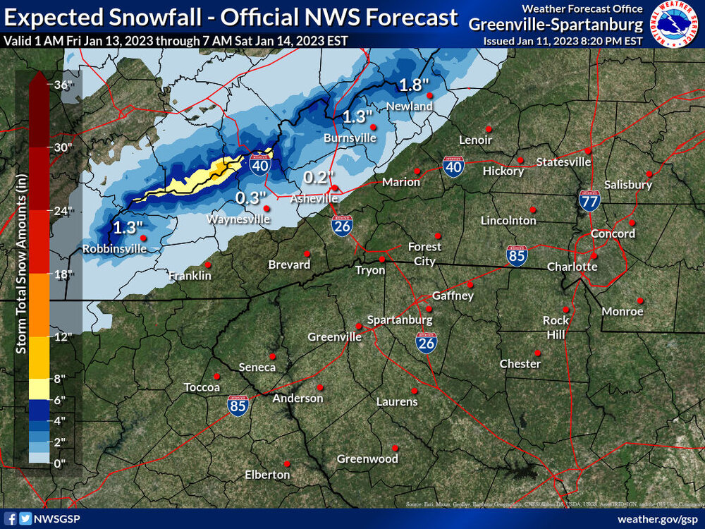
-
2022-2023 Fall/Winter Mountains Thread
nchighcountrywx replied to BlueRidgeFolklore's topic in Southeastern States
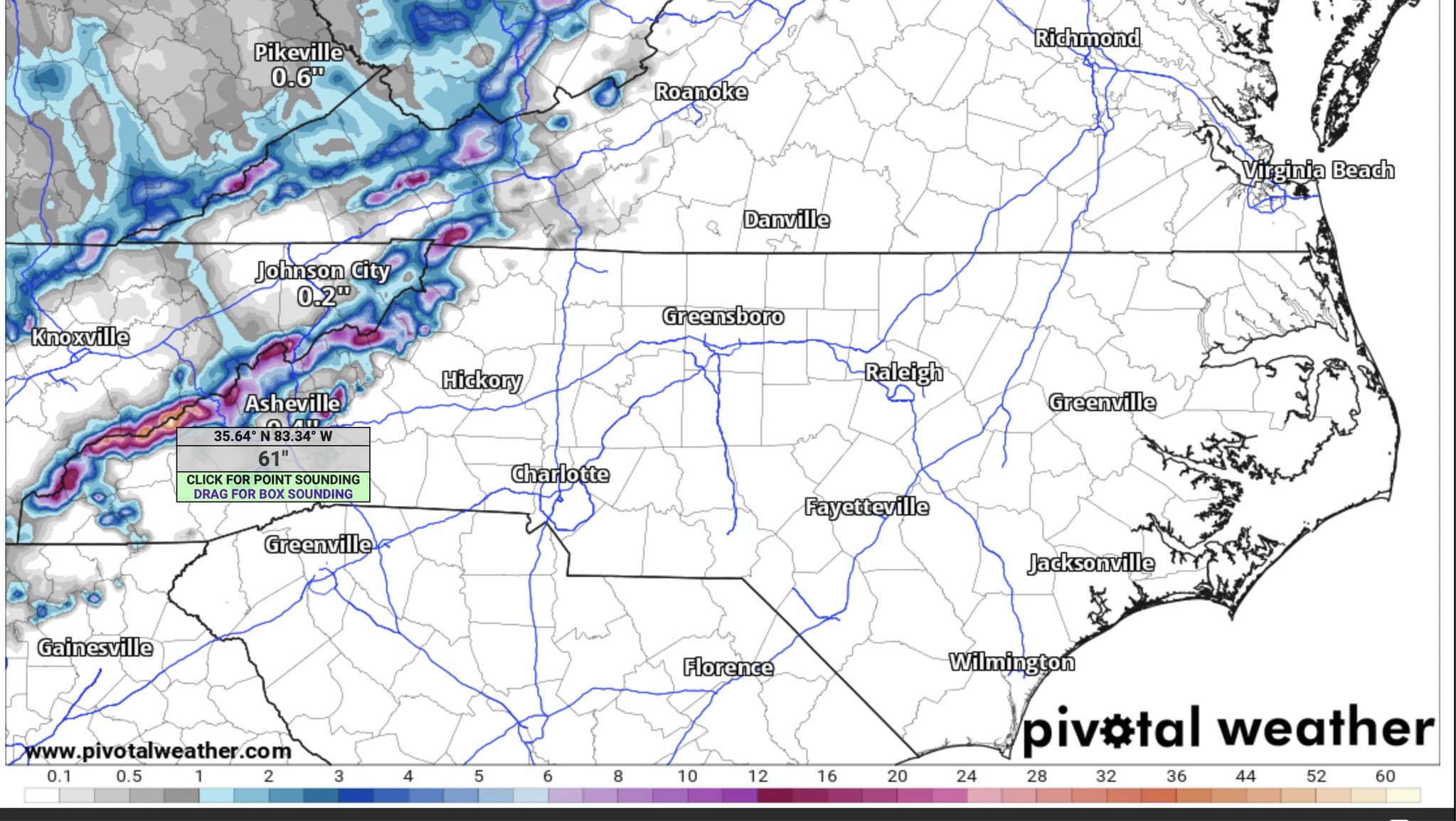
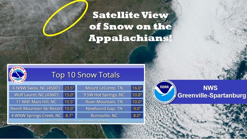
NAM modeling 61” snow at Clingman’s Dome!
-
2022-2023 Fall/Winter Mountains Thread
nchighcountrywx replied to BlueRidgeFolklore's topic in Southeastern States
-
2022-2023 Fall/Winter Mountains Thread
nchighcountrywx replied to BlueRidgeFolklore's topic in Southeastern States
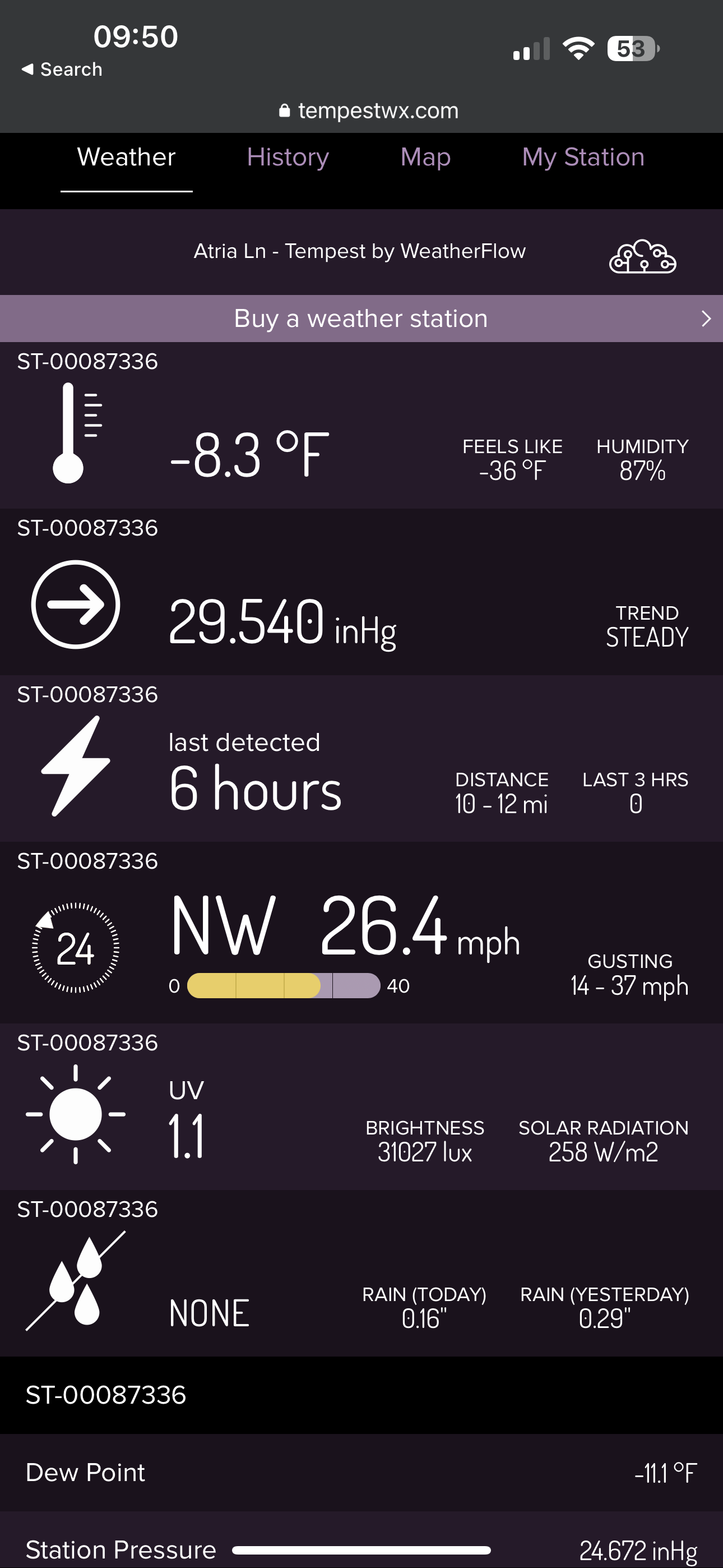
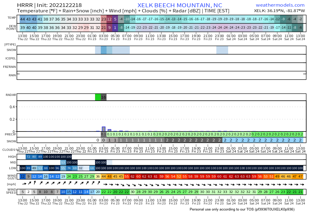
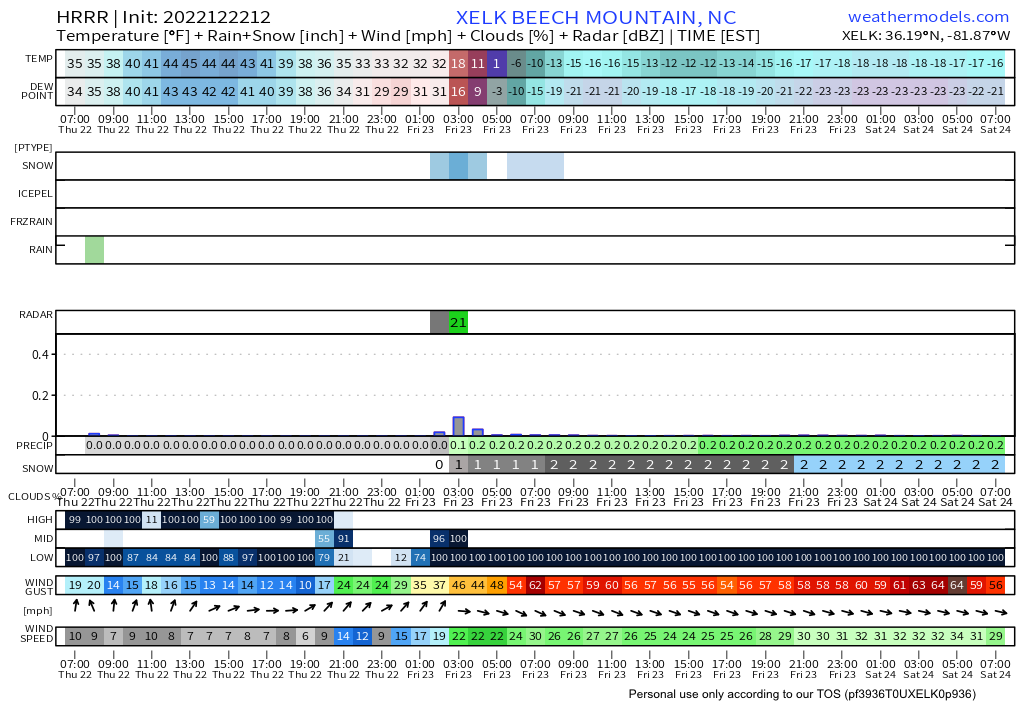
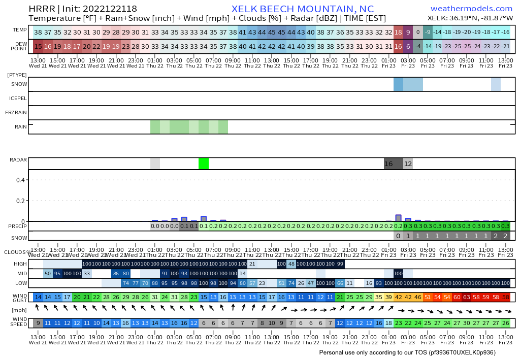
Appears headed to -20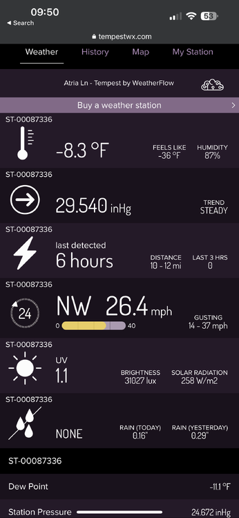
-
2022-2023 Fall/Winter Mountains Thread
nchighcountrywx replied to BlueRidgeFolklore's topic in Southeastern States
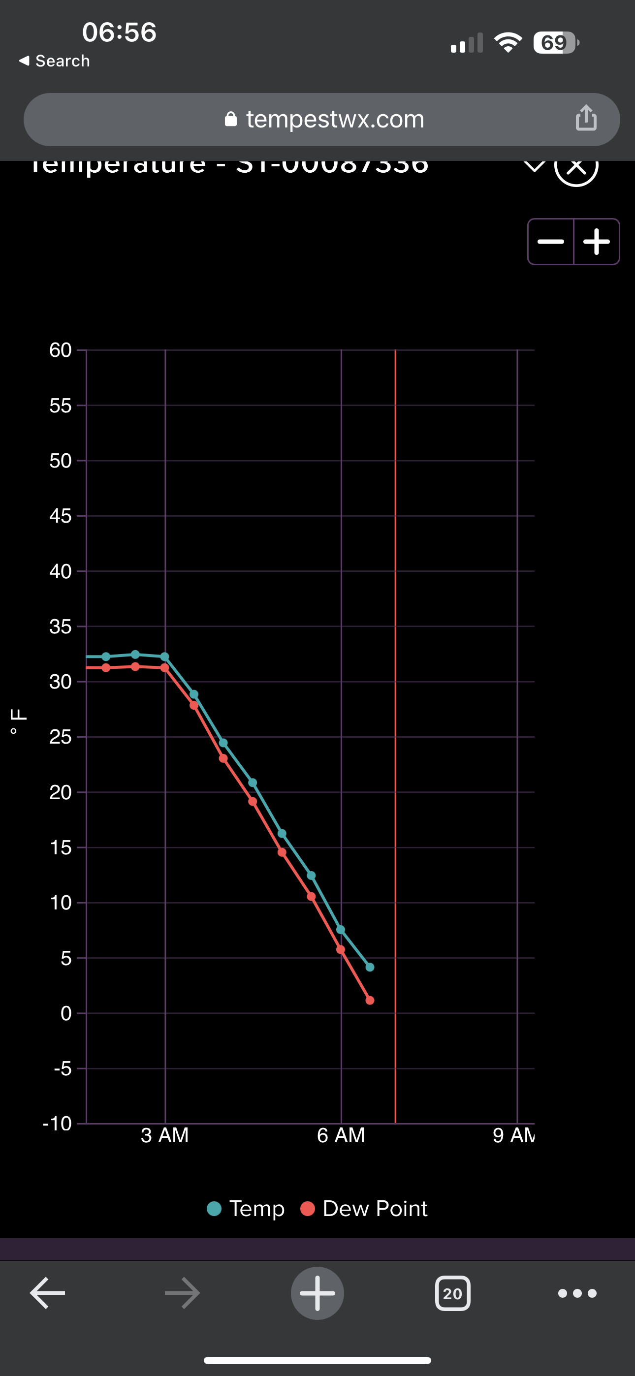
https://tempestwx.com/station/81986/grid -
2022-2023 Fall/Winter Mountains Thread
nchighcountrywx replied to BlueRidgeFolklore's topic in Southeastern States
It’s here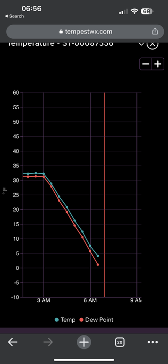
-
2022-2023 Fall/Winter Mountains Thread
nchighcountrywx replied to BlueRidgeFolklore's topic in Southeastern States
-
2022-2023 Fall/Winter Mountains Thread
nchighcountrywx replied to BlueRidgeFolklore's topic in Southeastern States
-
2022-2023 Fall/Winter Mountains Thread
nchighcountrywx replied to BlueRidgeFolklore's topic in Southeastern States
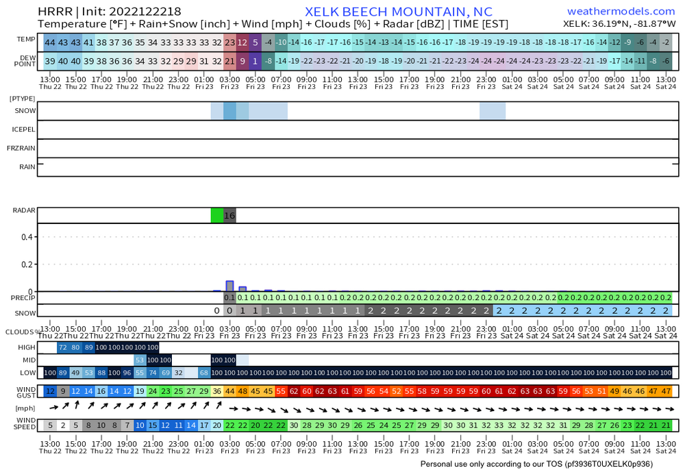
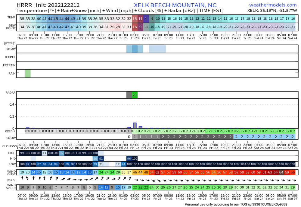
HRRR has Beech Mountain at -20F during the day Friday. Be ready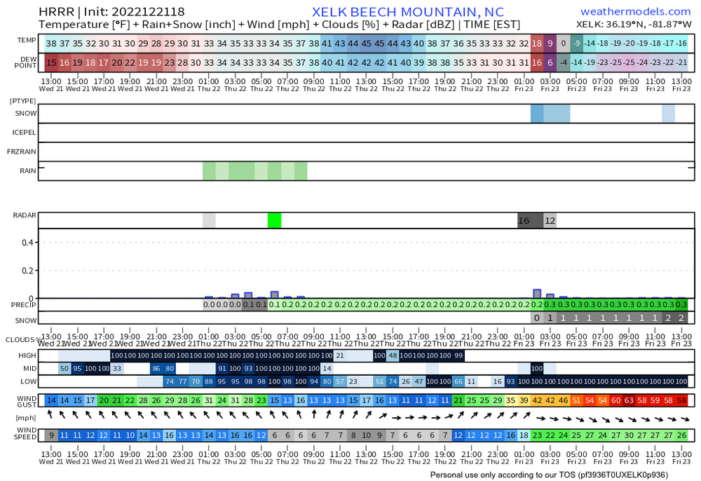
-
2022-2023 Fall/Winter Mountains Thread
nchighcountrywx replied to BlueRidgeFolklore's topic in Southeastern States
Significant warning occurred overnight with temps rising 12 degrees above 4500’. Cold rain Tuesday -
2022-2023 Fall/Winter Mountains Thread
nchighcountrywx replied to BlueRidgeFolklore's topic in Southeastern States
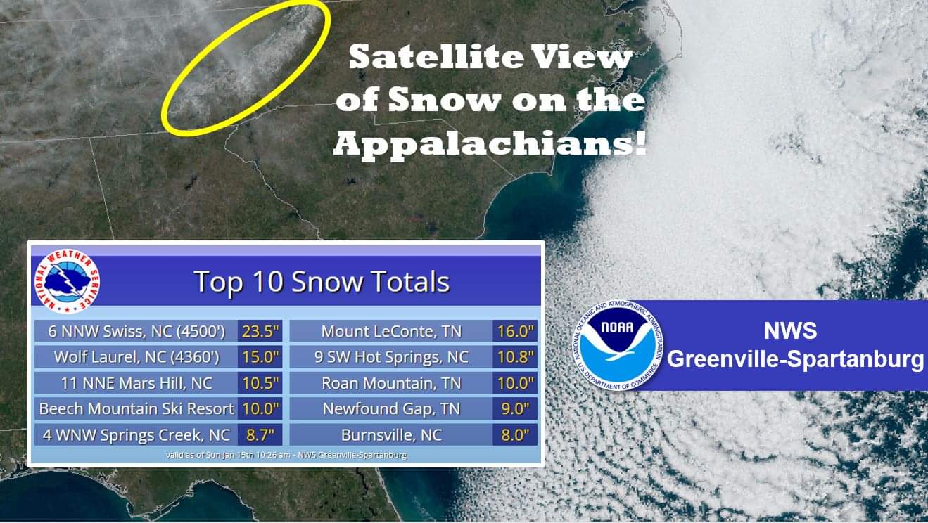
16.5 Grandfather Mountain. 12.7 Mount Mitchell -
2022-2023 Fall/Winter Mountains Thread
nchighcountrywx replied to BlueRidgeFolklore's topic in Southeastern States
AS OF 630 AM EDT TUESDAY: IR SATELLITE CLOUD TOP TEMPERATURES OF MINUS 8 TO MINUS 10 DEC C CONTINUE TO SUPPORT THE POTENTIAL FOR SPOTTY SNOW FLURRIES ALONG AND NEAR THE TN BORDER IN NORTHWEST UPSLOPE FLOW. ISOLATED TO SCATTERED FLURRIES MAY CONTINUE THROUGH THE DAY AS THE SHALLOW UPSLOPE MOISTURE BRIEFLY INCREASES AND A BAND OF VORTICITY ARRIVES ALOFT. OTHERWISE, A DEEP AND COLD TROUGH WILL REMAIN IN PLACE OVER THE EASTERN CONUS THROUGH THE NEAR TERM PERIOD. DESPITE GOOD INSOLATION EVERYWHERE EXCEPT THE SPINE OF THE SOUTHERN APPALACHIANS, MAXIMUM TEMPERATURES WILL STRUGGLE IN THE 50S EAST OF THE MOUNTAINS, WITH PLENTY OF 30S AND 40S ACROSS THE HIGH TERRAIN - RUNNING SOME 15 TO 25 DEGREES BELOW NORMAL IN MANY LOCATIONS! -
2021-2022 Fall/Winter Mountains Thread
nchighcountrywx replied to BlueRidgeFolklore's topic in Southeastern States
Yes https://imgur.com/gallery/bqkxWw4 -
2021-2022 Fall/Winter Mountains Thread
nchighcountrywx replied to BlueRidgeFolklore's topic in Southeastern States
-
Fox Weather coming this year along with a new streaming weather service from The Weather Channel https://www.theatlantic.com/culture/archive/2021/07/fox-news-weather-channel/619408/
-
2020/2021 Fall/Winter Mountain thread
nchighcountrywx replied to Met1985's topic in Southeastern States
GSP: THE ARRIVAL OF THE COLD AIR WILL RAPIDLY BRING SFC TEMPS INTO THE 30S AT HIGH ELEVATIONS BEGINNING LATE EVENING; FREEZING LEVELS WILL CONTINUE TO FALL SUCH THAT MIN TEMPS REACH THE MID 20S IN HIGHER ELEVATIONS IN THE MORNING (MIN TEMP RECORD AT AVL DOES NOT LOOK TO BE IN JEOPARDY). STILL LOOKING FAIRLY IMPRESSIVE IN TERMS OF A NW FLOW SNOW EVENT, WITH THE MAJOR "CLASSIC" INGREDIENTS LOOKING TO COME TOGETHER TO PRODUCE ACCUMULATING SNOW. THE STRONG WINDS AND RAPID COOLING OF THE MIXED LAYER WOULD SUGGEST ABOVE-AVERAGE SLRS, AND A NUMBER OF SOURCES STILL DEPICT A SMALL AMOUNT OF INSTABILITY. STILL THINKING WE WILL SEE A GREAT LAKES CONNECTION; ALWAYS TRICKY TO FIND GUIDANCE THAT PRODUCES BELIEVABLE QPF IN THE UPSLOPE AREAS, BUT FEELING PRETTY GOOD ABOUT SNOW TOTALS OF 1 TO 2 INCHES IN MOST OF THE NW FLOW ZONE, WITH ISOLATED 3". QPF TAPERS OFF AFTER 18Z, BUT AT LEAST SOME FLURRIES MAY LINGER INTO THU EVENING. -
2020/2021 Fall/Winter Mountain thread
nchighcountrywx replied to Met1985's topic in Southeastern States
https://www.hcpress.com/news/active-winter-season-has-dropped-over-two-feet-of-snow-in-boone-with-just-under-three-weeks-of-winter-remaining.html?fbclid=IwAR00qvOVXVzLsa8h_jLtscXm6xmvSd7_aEVZTYIxRw37ghiB9eVSljr9iCw Coldest Temperatures This Winter Beech Mountain: 0 degrees (December 26) Blowing Rock: 7 degrees (December 26) Boone: 9 degrees (December 26) Deep Gap: 10 degrees (December 26) Linville: 5.4 degrees (December 26) Sugar Mountain: -1 Degree (December 26) Valle Crucis: 9.7 degrees (December 26) West Jefferson: 8.9 degrees (December 26) Snow Totals This Winter Beech Mountain: 52.7 inches Boone: 25.7 inches Sugar Mountain: 78.5 inches -
February 18-19 MAJOR Ice Storm Threat
nchighcountrywx replied to NorthHillsWx's topic in Southeastern States
Exactly. Knowledgeable ones knew yesterday it would bust in many areas This type of bust is really a huge blessing. Our lineman brothers in Virginia especially Southern Virginia cooperatives are still slammed from last Friday night with over half of the customers in Southside Virginia cooperative still out -
Anyone wishing for ice should think twice Southside Electric Cooperative in southern Virginia this morning still has 77% of their customers out this morning 48 hours after the event. Their area was torn up by ice Our lineman need a break. They work harder than any NFL Lineman ever does. Jacking and restringing wire and establishing equipotential grounding zones around the lineman to protect them from generator back feeds is tedious hard work. https://poweroutage.us/area/state/virginia