nchighcountrywx
-
Posts
2,669 -
Joined
-
Last visited
Content Type
Profiles
Blogs
Forums
American Weather
Media Demo
Store
Gallery
Everything posted by nchighcountrywx
-
2023-2024 Fall/Winter Mountain Thread
nchighcountrywx replied to The Alchemist's topic in Southeastern States
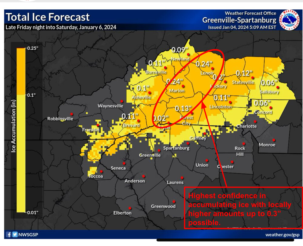
Alexander-Henderson-Caldwell Mountains-Greater Caldwell-Burke Mountains-Greater Burke-McDowell Mountains-Eastern McDowell-Rutherford Mountains-Polk Mountains-Including the cities of Bethlehem, Ellendale, Millersville,Taylorsville, Hiddenite, Stony Point, Hendersonville, Fletcher,Dana, East Flat Rock, Tuxedo, Etowah, Patterson, Kings Creek,Lenoir, Sawmills, Granite Falls, Jonas Ridge, Morganton,Pleasant Grove, Valdese, Ashford, Sugar Hill, Woodlawn, Old Fort,Marion, Nebo, Dysartsville, Fero, Glenwood,Chimney Rock State Park, and Saluda354 AM EST Thu Jan 4 2024...WINTER STORM WATCH IN EFFECT FROM LATE FRIDAY NIGHT THROUGHSATURDAY AFTERNOON...* WHAT...Heavy mixed precipitation possible. Total snow and sleetaccumulations of up to a half inch and ice accumulations of twotenths to one quarter of an inch possible. Isolated areas couldsee ice accumulations up to three tenths of an inch.* WHERE...Portions of piedmont and western North Carolina.* WHEN...From late Friday night through Saturday afternoon.* IMPACTS...Plan on slippery road conditions.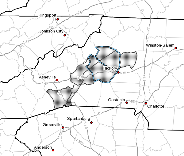
-
2023-2024 Fall/Winter Mountain Thread
nchighcountrywx replied to The Alchemist's topic in Southeastern States
Updated morning decision support briefing from GSP Winter Storm Watch Issued https://www.weather.gov/media/gsp/YouTube/brief.pdf -
2023-2024 Fall/Winter Mountain Thread
nchighcountrywx replied to The Alchemist's topic in Southeastern States
-
Mid to Long Range Discussion ~ 2023
nchighcountrywx replied to buckeyefan1's topic in Southeastern States

-
2023-2024 Fall/Winter Mountain Thread
nchighcountrywx replied to The Alchemist's topic in Southeastern States

-
2023-2024 Fall/Winter Mountain Thread
nchighcountrywx replied to The Alchemist's topic in Southeastern States
NCZ033-049-050-180345-/O.NEW.KGSP.WW.Y.0008.231218T1100Z-231219T1100Z/Avery-Yancey-Mitchell-Including the cities of Ingalls, Banner Elk, Newland, Swiss,Burnsville, Celo, Micaville, Ramseytown, Busick, Spruce Pine,and Poplar238 PM EST Sun Dec 17 2023...WINTER WEATHER ADVISORY IN EFFECT FROM 6 AM MONDAY TO 6 AM ESTTUESDAY...* WHAT...Snow expected. Total snow accumulations of 4 to 6inches. Winds gusting as high as 60 mph.* WHERE...Avery, Yancey and Mitchell Counties.* WHEN...From 6 AM Monday to 6 AM EST Tuesday.* IMPACTS...Travel could be very difficult. The hazardousconditions could impact the morning or evening commute. Strongwinds could cause tree damage. The cold wind chills as low as5 below zero could result in hypothermia if precautions arenot taken. -
2023-2024 Fall/Winter Mountain Thread
nchighcountrywx replied to The Alchemist's topic in Southeastern States
Snow #14 inbound for the high country above 5000' so far this winter. Keep counting them. -
Mid to Long Range Discussion ~ 2023
nchighcountrywx replied to buckeyefan1's topic in Southeastern States
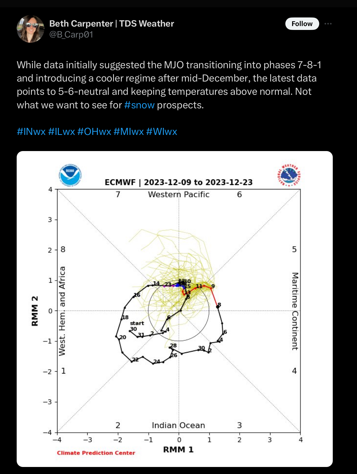
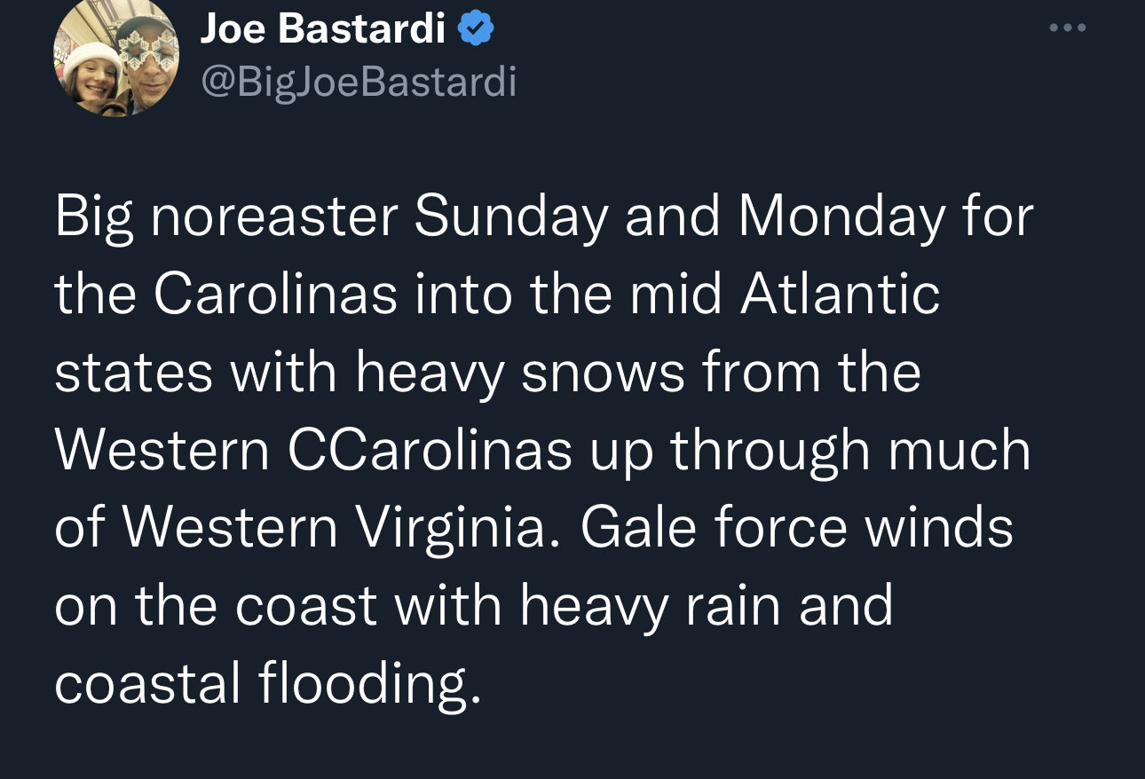
This is a shot across the bow. Major change in the outlook
-
2023-2024 Fall/Winter Mountain Thread
nchighcountrywx replied to The Alchemist's topic in Southeastern States
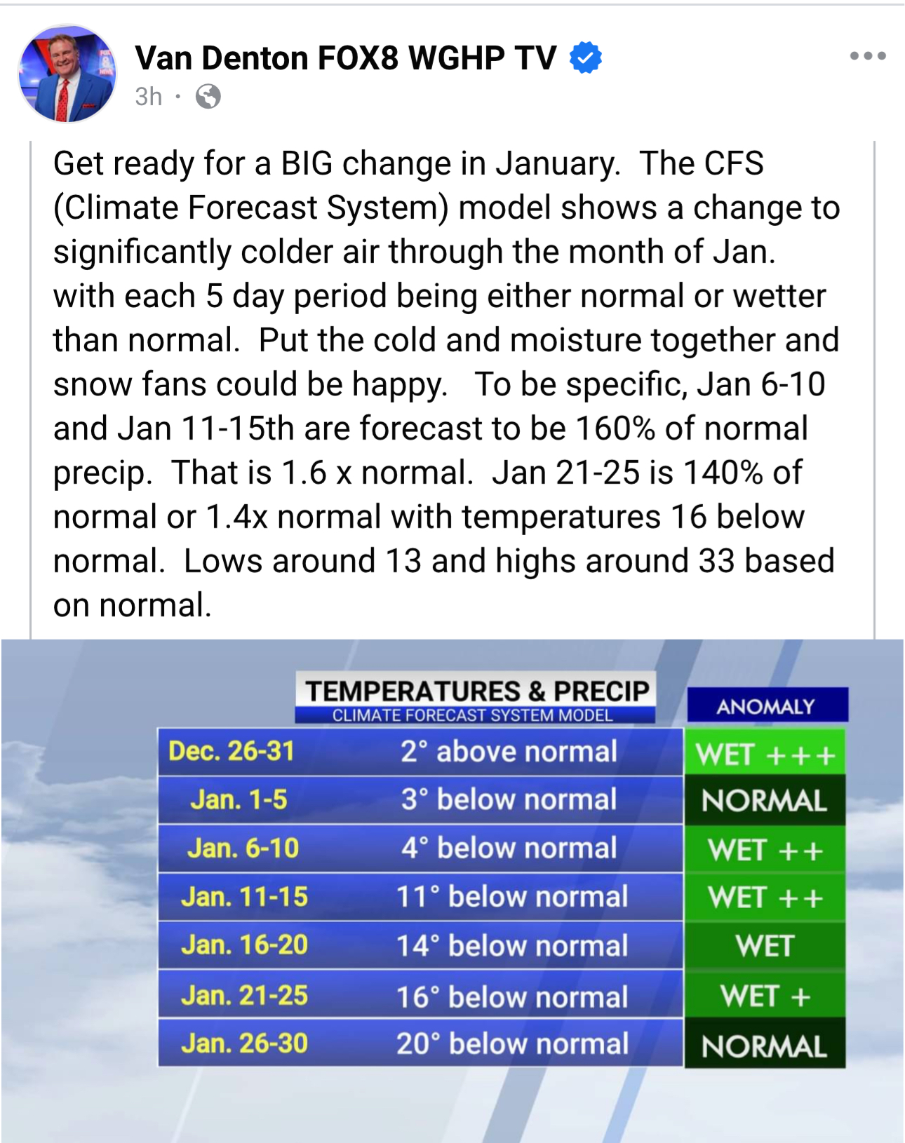
This is concerning
-
2023-2024 Fall/Winter Mountain Thread
nchighcountrywx replied to The Alchemist's topic in Southeastern States
-
2023 Mountains Spring/Summer Thread
nchighcountrywx replied to Tyler Penland's topic in Southeastern States
Is that trail access site relatively discreet public or is it by private access only. Thanks ! -
2023 Mountains Spring/Summer Thread
nchighcountrywx replied to Tyler Penland's topic in Southeastern States
STORM TOTAL QPF HAS FALLEN BELOW AN INCH WITH THIS PACKAGE OVER THE SOUTHERN HALF OF THE AREA, AND LESS THAN 1.5 INCHES ACROSS MUCH OF THE NC PIEDMONT. HOWEVER, GIVEN THE LONGER DURATION OF RAIN AND GREATER CONVECTIVE COMPONENT DEVELOPING SUNDAY, WE RETAIN 3 TO 5 INCH TOTALS ALONG SOME OF THE NORTHERN ESCARPMENT. WITH MUCH OF THAT DRAINING INTO THE CATAWBA BASIN, ELEVATED RIVER LEVELS COULD DEVELOP IN THE CATAWBA RESERVOIR CHAIN WHICH COULD HAVE LASTING EFFECTS INTO MONDAY -
2023 Mountains Spring/Summer Thread
nchighcountrywx replied to Tyler Penland's topic in Southeastern States
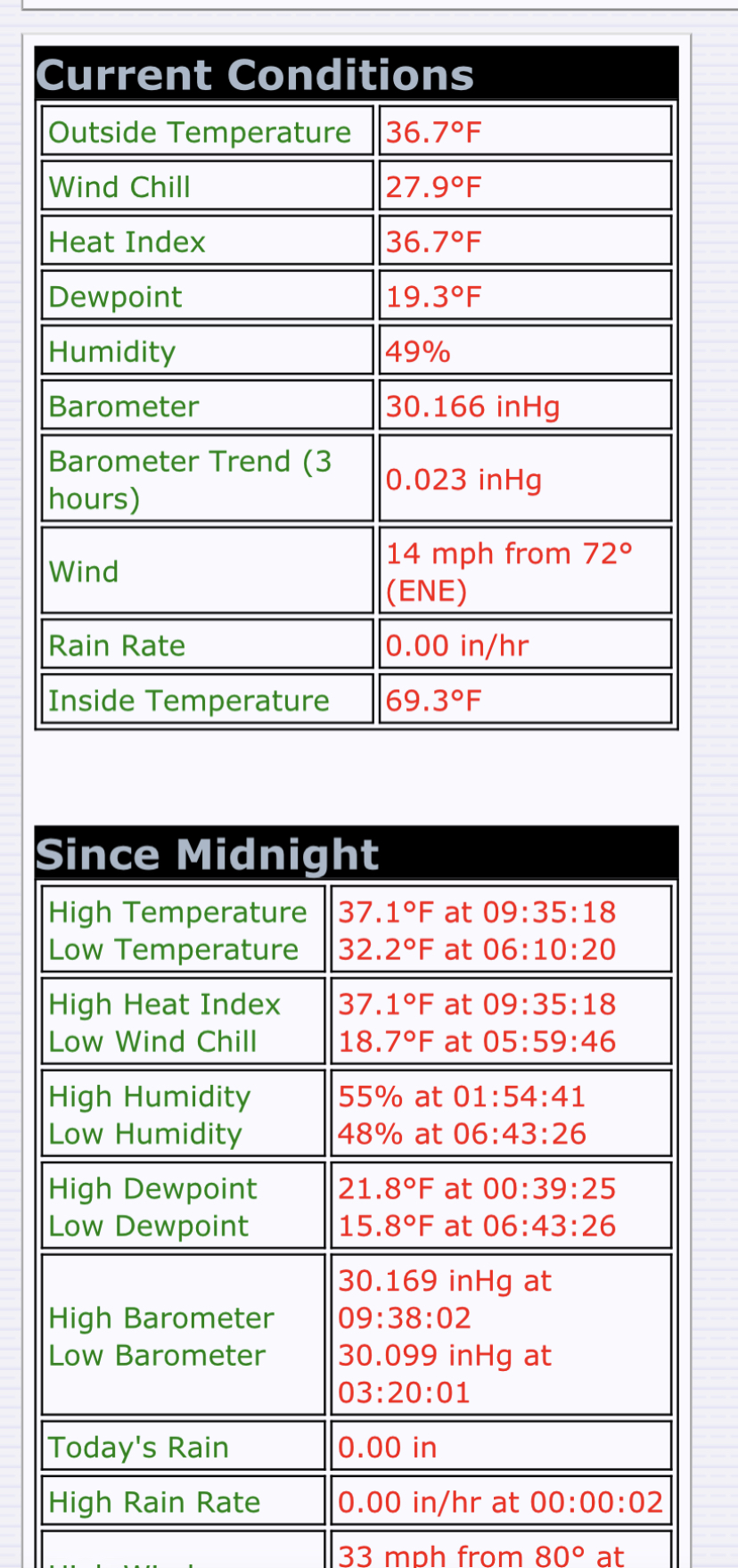
36.7 Mount Mitchell
-
2023 Mountains Spring/Summer Thread
nchighcountrywx replied to Tyler Penland's topic in Southeastern States
-
2023 Mountains Spring/Summer Thread
nchighcountrywx replied to Tyler Penland's topic in Southeastern States
48 pictures of the historic West Virginia May snow https://m.facebook.com/100069173240160/posts/pcb.544065694575867/?photo_id=544064421242661&mds=%2Fphotos%2Fviewer%2F%3Fphotoset_token%3Dpcb.544065694575867%26photo%3D544064421242661%26profileid%3D100028049062478%26eav%3DAfZE_6yIYjNV_nYHKWmrCSEQw3VSB2iGsWaG6TckBlM19i5lR09aXwSyuhTNW0yBDNY%26paipv%3D0%26source%3D48%26refid%3D52%26ref%3Dcontent_filter%26__tn__%3DEH-R%26cached_data%3Dfalse%26ftid%3D&mdp=1&mdf=1
-
2022-2023 Fall/Winter Mountains Thread
nchighcountrywx replied to BlueRidgeFolklore's topic in Southeastern States
Snow #14 for the season this morning -
2022-2023 Fall/Winter Mountains Thread
nchighcountrywx replied to BlueRidgeFolklore's topic in Southeastern States
Blue Ridge Parkway Wilkes-Alleghaney
-
2022-2023 Fall/Winter Mountains Thread
nchighcountrywx replied to BlueRidgeFolklore's topic in Southeastern States
High peaks are ready. https://climate.ncsu.edu/m/?id=GRANDFATHR https://nchighpeaks.org/davis/index.html https://tempestwx.com/station/81986/grid -
2022-2023 Fall/Winter Mountains Thread
nchighcountrywx replied to BlueRidgeFolklore's topic in Southeastern States
-
2022-2023 Fall/Winter Mountains Thread
nchighcountrywx replied to BlueRidgeFolklore's topic in Southeastern States
-
2022-2023 Fall/Winter Mountains Thread
nchighcountrywx replied to BlueRidgeFolklore's topic in Southeastern States
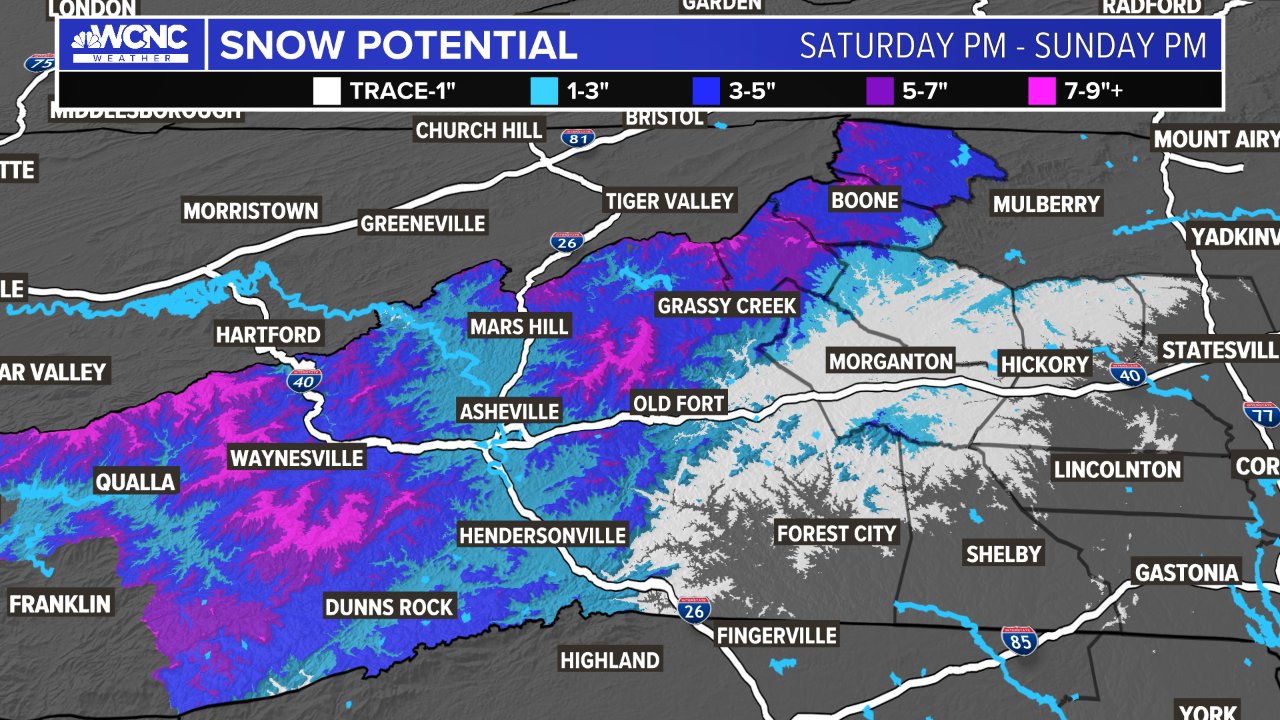
Panovich
-
2022-2023 Fall/Winter Mountains Thread
nchighcountrywx replied to BlueRidgeFolklore's topic in Southeastern States

-
2022-2023 Fall/Winter Mountains Thread
nchighcountrywx replied to BlueRidgeFolklore's topic in Southeastern States
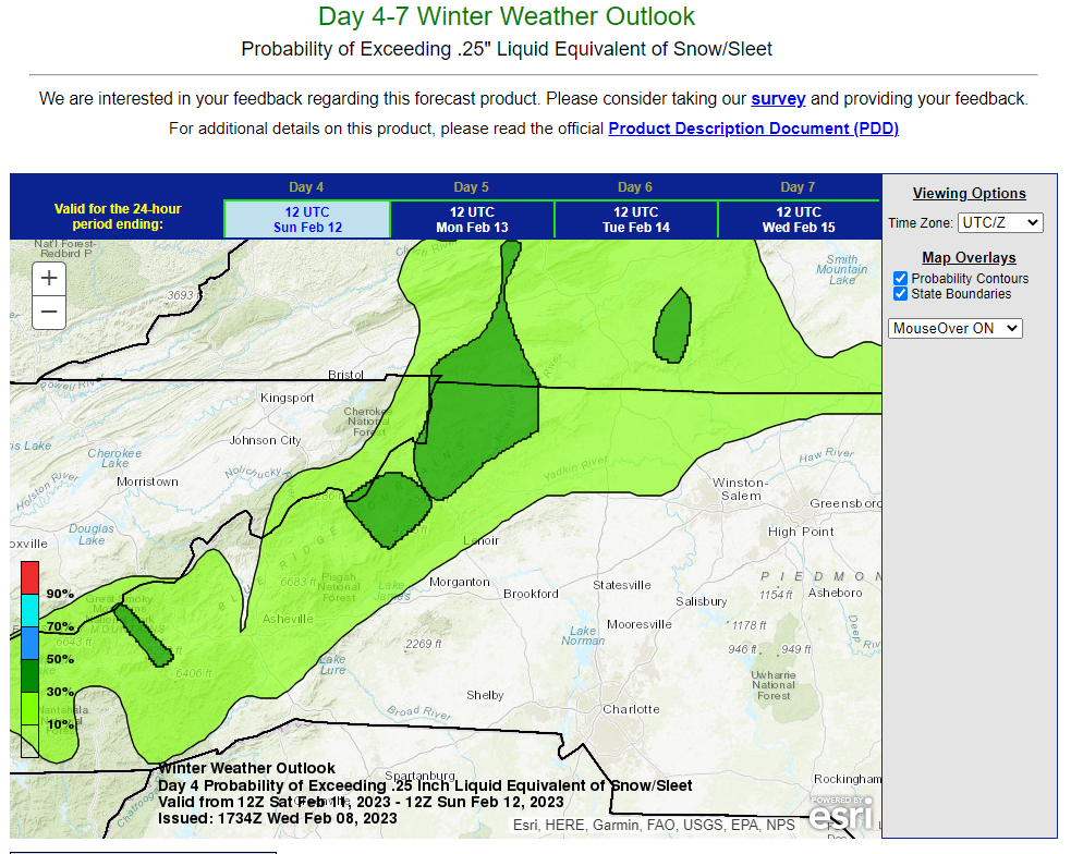
WPC updated....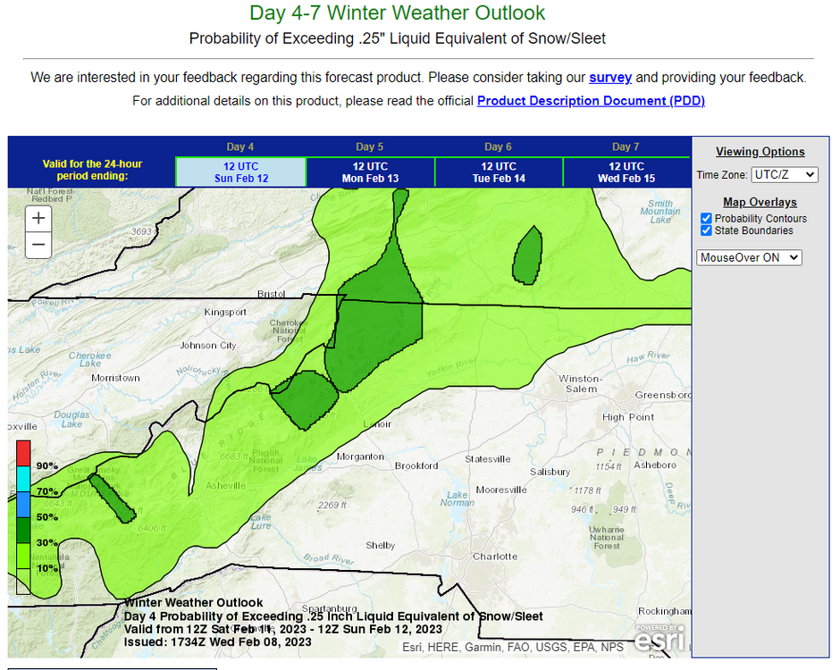
-
2022-2023 Fall/Winter Mountains Thread
nchighcountrywx replied to BlueRidgeFolklore's topic in Southeastern States
Mount Washington recorded a new record low of -47.1 breaking the old record from 1963 of -32. Prior to last night our historical -34 degree temperature in January 1987 when the stratosphere reached Mount Mitchell had them beat. -
2022-2023 Fall/Winter Mountains Thread
nchighcountrywx replied to BlueRidgeFolklore's topic in Southeastern States