nchighcountrywx
-
Posts
2,669 -
Joined
-
Last visited
Content Type
Profiles
Blogs
Forums
American Weather
Media Demo
Store
Gallery
Everything posted by nchighcountrywx
-
-
2024-2025 Fall/Winter Mountain Thread
nchighcountrywx replied to Buckethead's topic in Southeastern States
https://www.facebook.com/share/p/QhfQH2SkfFQhS6wp/ -
2024-2025 Fall/Winter Mountain Thread
nchighcountrywx replied to Buckethead's topic in Southeastern States
Being awfully quiet in our mountain thread I am concerned many are struggling with severe impacts from Helene. Prayers for all and reach out if help is needed https://x.com/ncemergency/status/1840028847292432671?s=46&t=FFGrWYuqJINrKdAyxhtzfg -
https://x.com/collinrugg/status/1839816558362624306?s=46&t=FFGrWYuqJINrKdAyxhtzfg
-
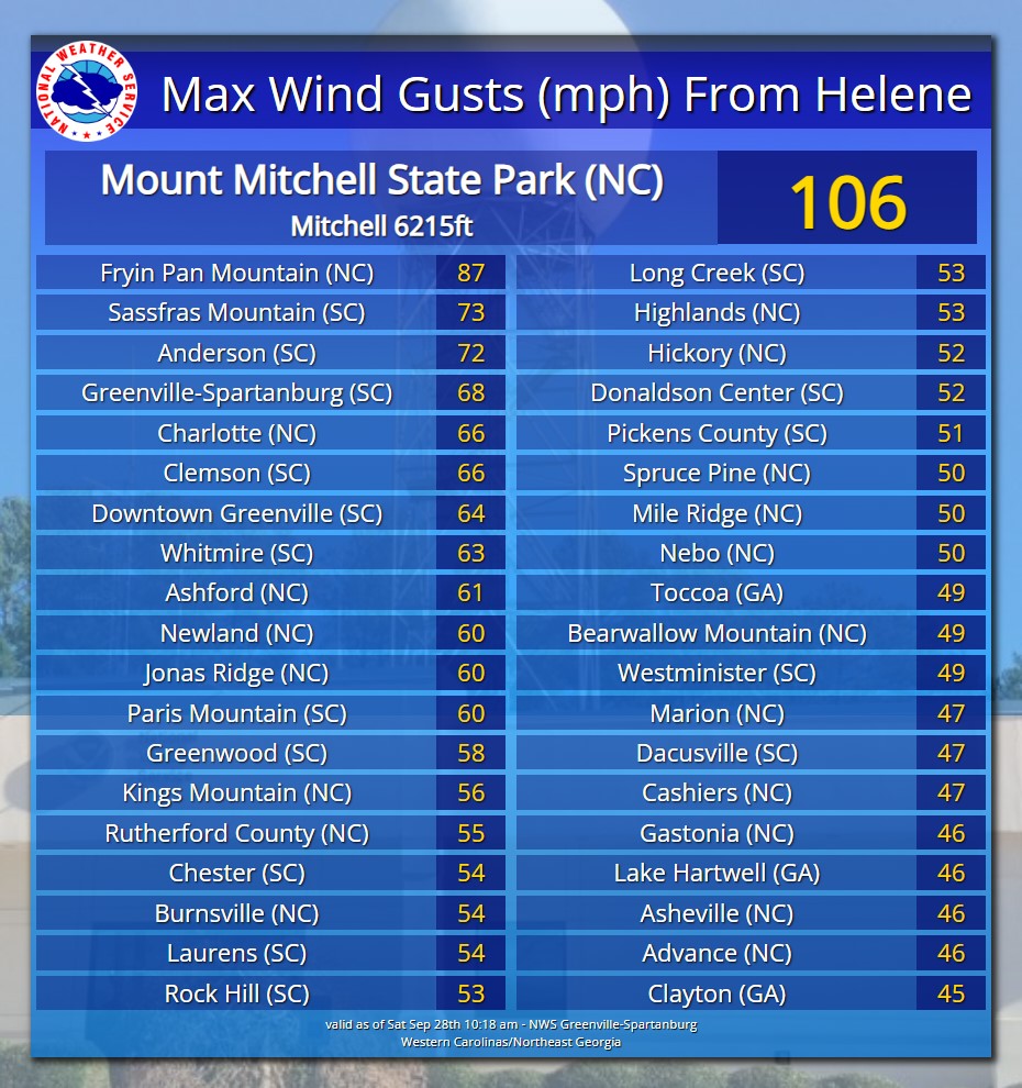
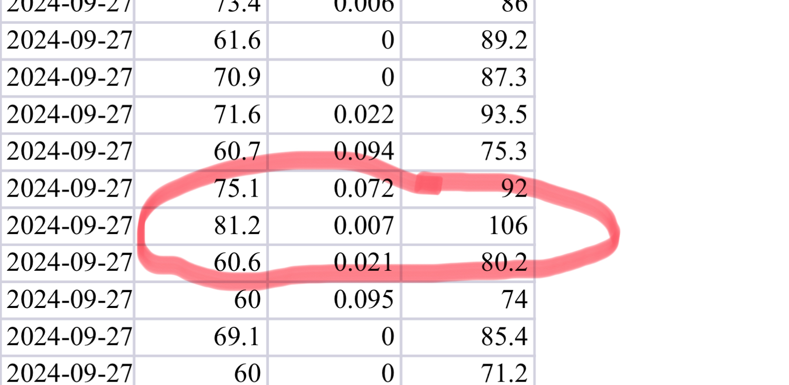
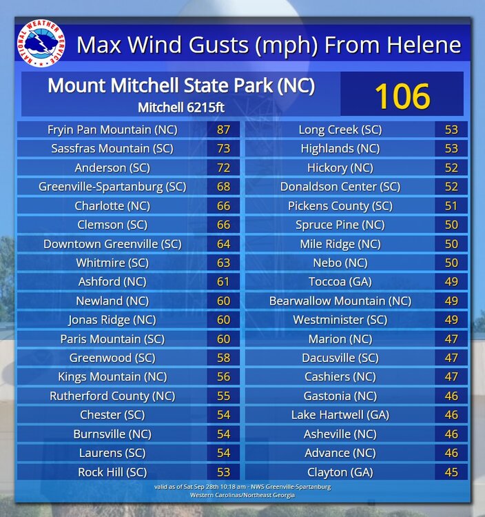
Mount Mitchell ranger station: sustained 81.2 gust to 106mph

-
2024-2025 Fall/Winter Mountain Thread
nchighcountrywx replied to Buckethead's topic in Southeastern States
Mount Mitchell ranger station: sustained 81.2 gust to 106mph
-
2024-2025 Fall/Winter Mountain Thread
nchighcountrywx replied to Buckethead's topic in Southeastern States
Highlights at the start of the work day this morning from the 230am GSP AFD 1. GSP says a possible storm precursor rain event across Western NC Wednesday depending on how the flow ahead of the storm sets up. 2. Starting Thursday afternoon and overnight 4 to 7 inches of rain is likely across the area with a possible foot of rain in the mountains . Thursday night wind: 30 - 50 mph gusts possible particularly just east of the cyclone center -
I head up Roaring Creek road a lot to access the AT and to cross country ski on some of the preservation land areas. As being in the shadow of Roan the area you are referring to gets mostly dust ups from down wind of Roan upslope events. The area usually does best on snow when the moisture and flow is from the easterly direction There is a properly sighted Tempest station at the top of Atria Lane at the link below: https://tempestwx.com/station/150620/grid
-
2024 Spring/Summer Mountain Thread
nchighcountrywx replied to Buckethead's topic in Southeastern States
Automated Twitter WeatherBOT list for area weather wire: Bookmark the link: https://x.com/i/lists/1822370690735202394 -
2024 Spring/Summer Mountain Thread
nchighcountrywx replied to Buckethead's topic in Southeastern States
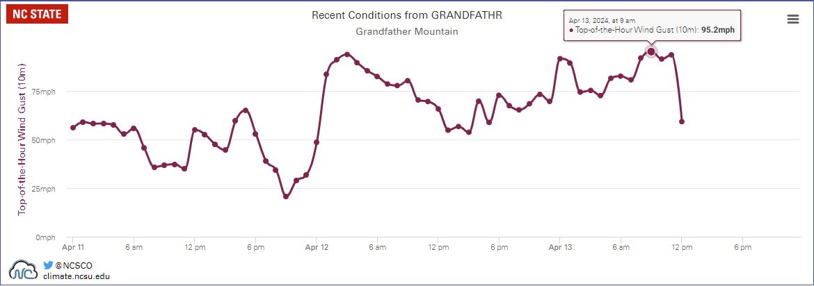
https://x.com/nwsgsp/status/1779177676390969593?s=46&t=FFGrWYuqJINrKdAyxhtzfg Gust to 95.2mph at Grandfather within the last hour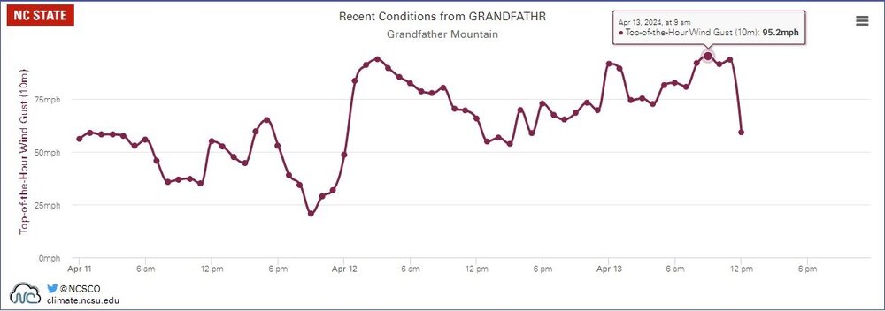
-
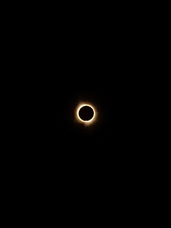
2024 Spring/Summer Mountain Thread
nchighcountrywx replied to Buckethead's topic in Southeastern States
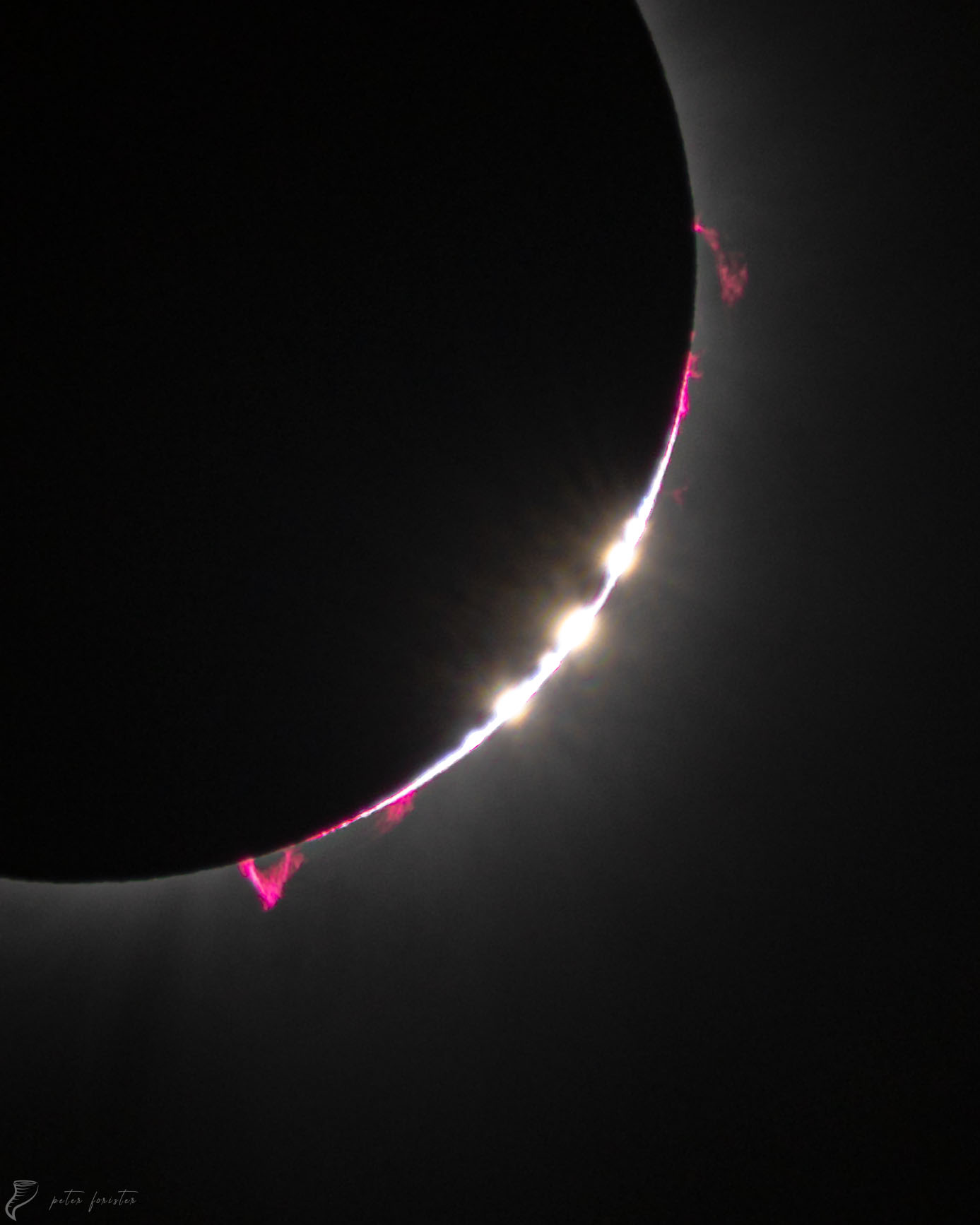
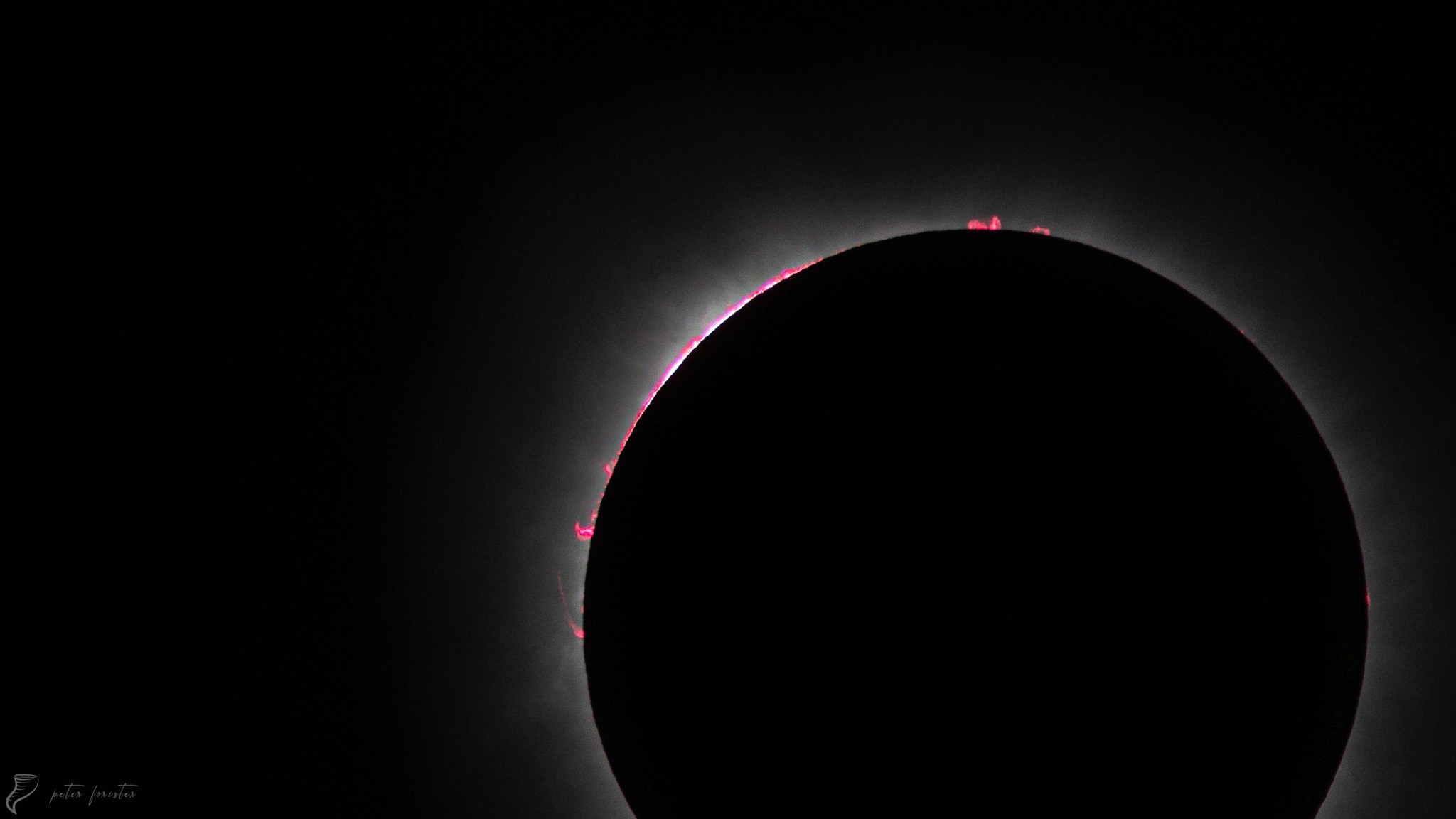
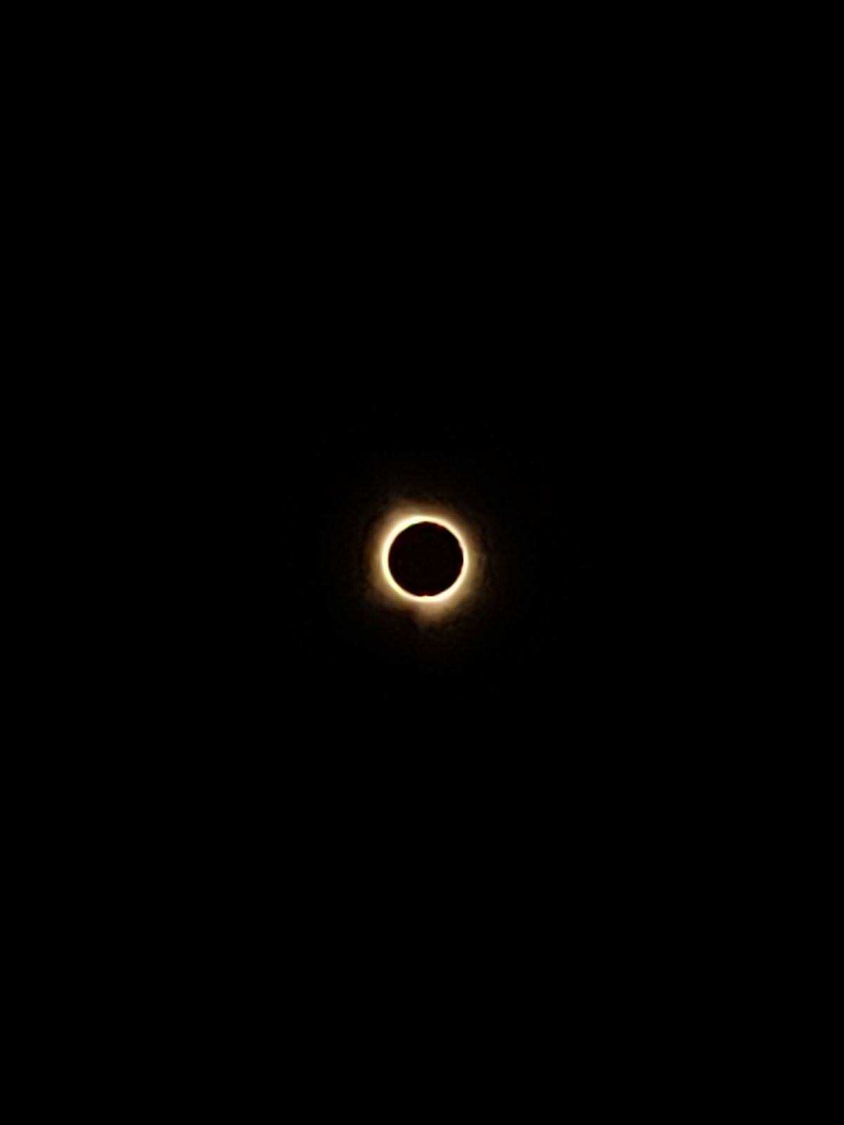
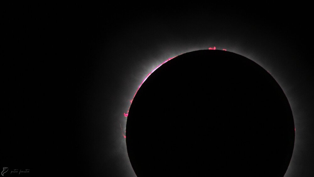
More awesome eclipse photos courtesy of: https://www.facebook.com/PeterForisterPhoto
-
2024 Spring/Summer Mountain Thread
nchighcountrywx replied to Buckethead's topic in Southeastern States
Taken by a brother of a co-worker from Ohio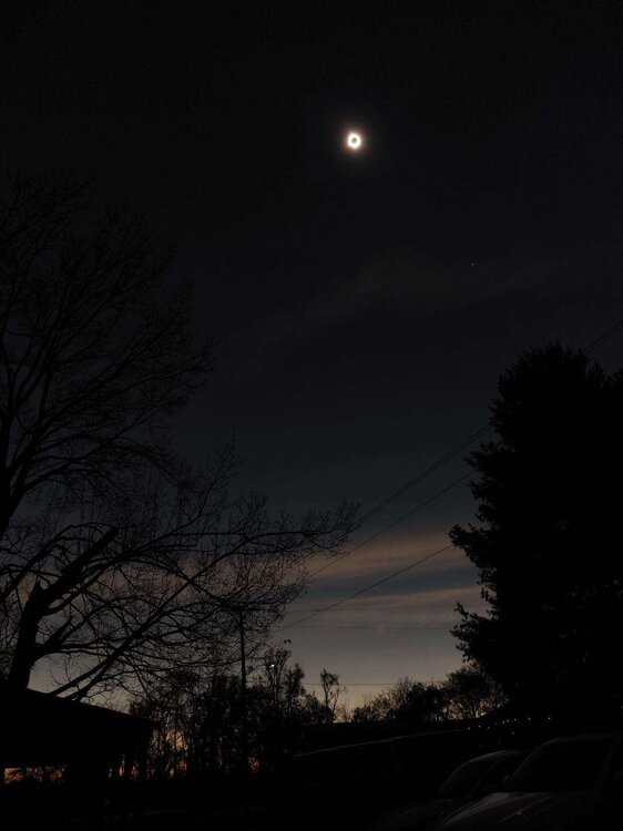
-
2024 Spring/Summer Mountain Thread
nchighcountrywx replied to Buckethead's topic in Southeastern States
Timm: Your photos are total awesomeness. I am grateful for you sharing them. -
2024 Spring/Summer Mountain Thread
nchighcountrywx replied to Buckethead's topic in Southeastern States
ACCUMULATING SNOW EXPECTED ACROSS THE HIGH ELEVATIONS OF THENORTH CAROLINA MOUNTAINS THROUGH FRIDAY...Intermittent snow showers are expected across the high elevationsof the North Carolina mountains through Friday. By Friday evening,accumulations ranging from a dusting to up to 3 inches are expectedacross much of the area above 3500 feet. Locally higher amounts of6 inches or more are expected on the high peaks and ridge topsalong the Tennessee border. Motorists traveling across the highelevations through Friday should use extra caution. -
2024 Spring/Summer Mountain Thread
nchighcountrywx replied to Buckethead's topic in Southeastern States
THIS REGIME WILL EVOLVE INTO MORE OF A NW FLOW SCENARIO TONIGHT ON THE WEST SIDE OF THE UPPER TROUGH. SNOW LEVELS HAVE LOWERED TO AROUND 3000 FEET OR SO THIS MORNING, BUT WILL LIFT TO 3500-4000 FEET WITH DIURNAL HEATING LATER TODAY. ACCUMULATING SNOWFALL IS EXPECTED TO BE LIMITED TO AROUND 3500 FEET AND ABOVE ACROSS THE NORTHERN NC MTNS, AND MORE LIKE ABOVE 4000' ACROSS THE REMAINDER OF THE AREA. SINCE THIS IS NOT A "TRADITIONAL" NW FLOW EVENT (SMALL UPSLOPE COMPONENT DUE TO WESTERLY LOW LEVEL FLOW), EVEN AREAS THAT WOULD NORMALLY SEE VIRTUALLY CONTINUOUS SNOW IN A TRUE UPSLOPE EVENT WILL SEE "SHOWERY" CONDITIONS IN THE TRUEST SINCE, AND IN FACT, SNOWPACK COULD UNDERGO SOME DEGREE OF MELTING IN BETWEEN BOUTS OF SHOWERS DUE TO MARGINAL TEMPERATURES. THIS MAKES THE SNOWFALL FORECAST AND WHAT TO DO IN TERMS OF WINTER WX HEADLINES A BIT PROBLEMATIC. THE CURRENT FORECAST HAS GENERAL 1-4" AMOUNTS IN THE AFOREMENTIONED HIGH ELEVATION AREAS ALONG THE TN/NC BORDER THROUGH THE END OF THE PERIOD, WITH LOCALLY HIGHER AMOUNTS ON THE HIGH PEAKS AND RIDGE TOPS ALONG THE IMMEDIATE STATE LINE. THIS IS JUST ENOUGH TO WARRANT A WINTER WX ADVISORY FOR AVERY COUNTY, WHILE AN SPS SHOULD SUFFICE FOR THE REMAINDER OF THE MOUNTAINS. -
2023-2024 Fall/Winter Mountain Thread
nchighcountrywx replied to The Alchemist's topic in Southeastern States
https://www.weather.gov/gsp/winter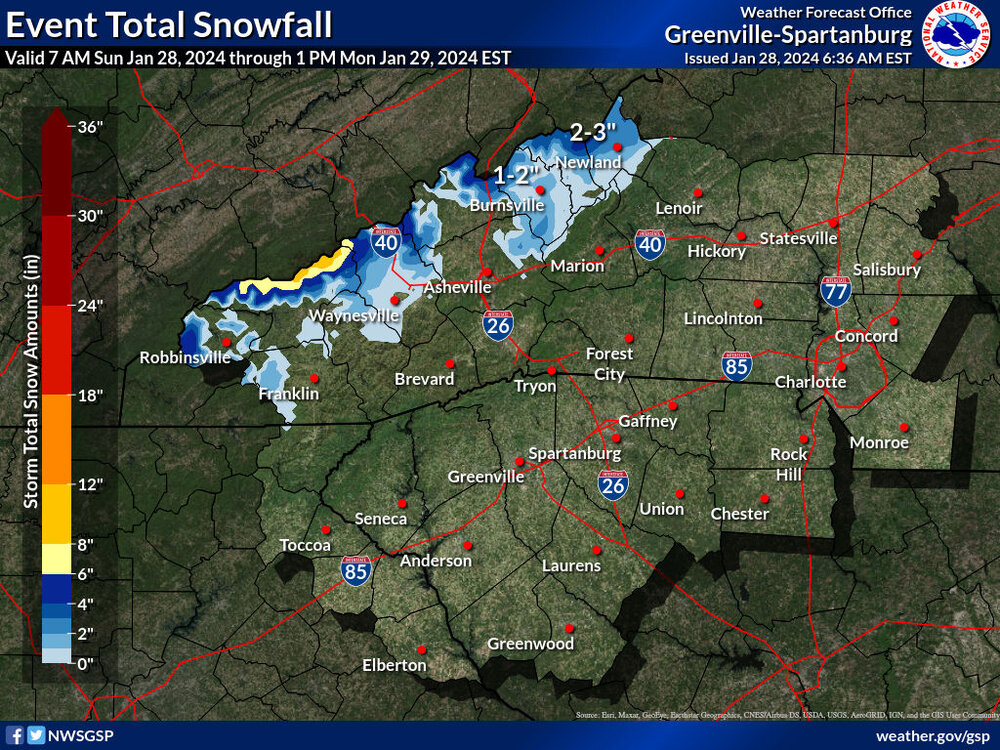
-
2023-2024 Fall/Winter Mountain Thread
nchighcountrywx replied to The Alchemist's topic in Southeastern States
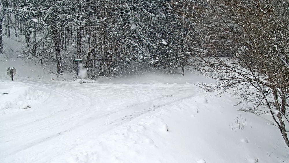
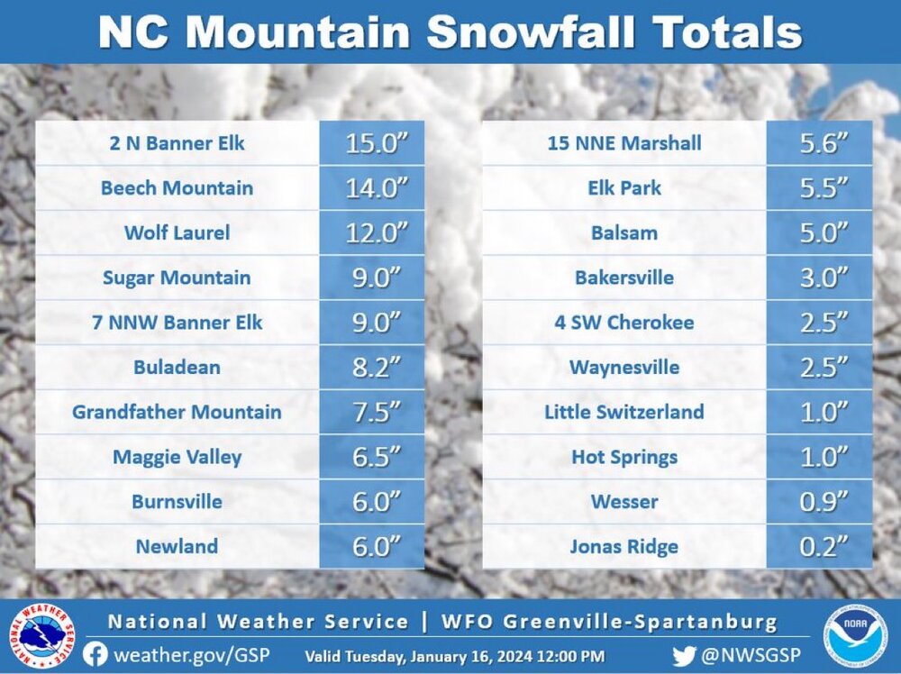
Snow reports from Saturday from Raysweather: Howard's Knob Watauga 8 There is about 8 inches total at the end of 1/20/24. The strong winds created deep (~24 inches) drifting in this area. Wolf Laurel Madison 7.5 Finished with 7.5 inches. Total includes report from yesterday. Snow lasted until 7pm. Currently-3° Calloway Gap Ashe 2.5 0.5 new snow overnight. Soft, powdery, fluffy and brrrr☃️ Livingston Farms (Fletcher) Buncombe 0.25 A light dusting Grassy Creek Community (Spruce Pine) Mitchell 3 Total snowfall for yesterday, 1/19/24 is 3 inches Kenilworth, Asheville Buncombe 0.3 Although snow showers continued, the accumulation at 9 am is the same as 5 pm yesterday. Mountain City, TN Johnson 4 Snow continued falling all through the night Dogtown Reporter (Minneapolis, NC) Avery 5.8 At 12:30 today we have a total of almost 6 inches. It's hard to measure with the wind and the leftover snow from the Monday and Tuesday event. It's currently snowing lightly (arctic haze) at 2:30. I will report at the end of the day or late evening, if we have more accumulation. Upper Laurel Madison 1.5 Snow flurries accumulated an additional 1.5 inches of snow overnight (measured at 8AM). The snow flurries started this morning and tapered off at about 5 PM. Moderate dusting but not measurable except for the 1.5 inches recorded early this morning. Creston (Sutherland Valley) Ashe 10.5 Snow total so far from today and yesterday. Was 4" by sunset Friday night, then another 6.5" overnight. Total 10.5 by 8:20 am Saturday. Still snowing, but light as of noon. Wind starting to pick up. Never mind, it's snowing again. Fines Creek Haywood 4 steady light to moderate snow fell overnight only flurries remain as of 8am, temp at 8am is 3 degrees Valle Crucis -- Mast Store Annex Watauga 1.5 Additional snow accumulation overnight. Strong winds and brutally cold single digit temps. Twin Rivers/Foscoe Watauga 5 Heavy snow continued most of Friday beginning with a glazing of ice. Totals of 5 more inches with the base of 6 inches last week. Without the strong winds,our accumulations would be greater. Amelia Community Alleghany 0 Snow flurries with no accumulation. Jefferson (Ashe Family Central) Ashe 1 1 inch of snow and calm winds Zionville Watauga 8.5 8.5” at 1 p.m. all flurries have stopped. Winkler's Creek Road Watauga 7 Additional light snow overnight, storm totals 7” by 9:00 AM. Beaverdam (North Asheville) Buncombe 0 on and off flurries and snow showers continued overnight in Beaverdam N Asheville. An additional inch for a total so far of 1.6. Temp is 11 at 10:00 Devil's Fork Gap Madison 2.7 At 7am the temp is 5 with calm wind. We have 2.7 inches of powdery snow in the last 24 hours with 1.2 inches since 5pm yesterday. We have about 5 inches of snow pack on the ground. Aho-Sorrento Watauga 2 An additional 2 inches of really dry snow overnight Arborcrest Gardens/Boone Watauga 8 (8" is the storm total since the snow started Fri morning. ) Let's be honest folks. This is sorta fun (the first big one of the season always is as long as you are warm and safe inside your home with no frozen pipes or power outgages) Has now been snowing without a complete break for 24 hours. Yesterday's strong winds have created some 2-3' drifts this morning. But the winds have quieted down at least so far this morning (10-15mph range) allowing the snow to 'stick' on the Fraser firs and other evergreens here in the gardens-really pretty. Faust Madison 1.5 Dawn: fluffy dry snow fell after midnight. Not currently snowing. Looks like ideal skiing powder. Certainly a set of snowshoes would aid a woodswalk. Mountain Glen Avery 10.3 Taken 12:34 pm. Fairway # 1 Mountain Glenn GC Beech Mountain - Fred's Avery 7 Appalachian Ski Mountain area Watauga 3 As of 7:45 am this morning add another 3 inches to yesterdays 4 inches here at ASM. Winds are starting to increase now so feel certain there will be some significant drifting. It is now 5 degrees and the "Arctic Haze" Ray often speaks of is in full effect today. Stay warm folks! Hardin Park Elementary Watauga 7 12:45 am update- 7 inches, still snowing. Three Top/Bluff Valley Ashe 4 8:00 Saturday we're at about 4". Light snow is still falling. Canton (Newfound Road) Haywood 0 A light dusting of snow Galax-Downtown Galax 0 An additional very light accumulation this morning from overnight flurries. Not enough to measure. Very cold but no wind as of right now. Bolens Creek Yancey 2.1 At 8:00 AM it is 9 degrees F on Bolens Creek. We got a bit more snow through the night. Blowing Rock Watauga 2 Additional 2 inches. Little Peak Creek (New River) Ashe 1.3 Snow flurries yesterday added another 1.3 inches so today, there's 3 inches of frozen, crunchy snow on the ground with a very fluffy, lite 1-1.3 inches added to that. Skies are mostly cloudy with the sun peaking out here & there with 17 degrees at 1PM Ashe Lake Ashe 0.1 Just a dusting overnight covering yesterday's light snow, but near zero at 8:00 a.m. Now sunny at noon; nothing melting, very slippery outside. Stony Fork Watauga 0.5 With an additional half inch that fell overnight, there is almost an inch at 7:00 am. 13 degrees here. Bethel Watauga 9 2” of new snow fell overnight, bringing the 8:00 am total to 9” from this Friday-Saturday storm. Idlewild Ashe 0.25 2.1 inches total from yesterday and today. We received 0.25 inches since midnight and is currently just flurries and 9 degrees at 7 am. Hopewell Church Community/Green Valley Watauga 8.25 10;am Well been waiting a long time for this big snow A snow spotter's dream! We had additional snow fall last night of about 1-1.5 in Hard to tell exactly how much because of wind blown snow, but after taking 4- 5 measurements around the yard our total is 8 in. Temp is 8 with light flurry action. ENJOY THE NC MOUNTAIN SNOW STAY SAFE AND WARM! Vilas Watauga 3 Amount since start on Friday. Probably had more but wind blew it around. Shady Valley, TN Johnson 9.5 This is the total for all accumulation this week. Steady snow fall continuing . Watauga Falls (Sugar Grove) Watauga 7 Got about 2 inches overnight to add onto the 5 from yesterday (Friday) Mills River Henderson 0 Temperature at 7:00 AM 9 degrees F. Trace amount of snow on grassy surfaces. Little Switzerland Mitchell 3 Its hard to get an accurate measurement because of the wind but my best estimate is 3 inches for the storm total from yesterday and last night as of Saturday 8am Roan Mountain TN, Upper Shell Creek Carter 8 Total of 8 inches for this storm. Western facing slope over 3200 ft. Snow has finally stopped at 5:30 pm Westwood Elementary Ashe 2 This is Friday- Saturday morning 8:30am. Deep Gap (Parkway School) Watauga 2 2 inches of additional overnight powdery snow Meat Camp Watauga 8 Additional snow over night raised the total from this snowfall from 4.5" to 8". Elk Trail (Asheville) Buncombe 1.5 As of 8:00 a.m. an inch and a half on open ground. Temp was 6.5. Fairview, NC (Whitaker) Buncombe 0.2 Light dusting overnight 1/19-1/20 covering grass. Oak Grove Watauga 12 10:45 am. Light snow falling so thinking that it's over for the most part. 12" in most parts of the yard. Waiting for the plow to clear the road. Blairmont Watauga 5 5 inches Total from storm. Average from drifts / low spots Sugar Mountain Ski Resort Avery 4 Peoria (near the NC/TN Border) Watauga 4.2 Continued snow throughout the night, light to moderate snow showers continue this morning. Seven Devils Watauga 7 Elev 4032, as of 9am: The 2 day total (1/19-1/20) is around 7”. Could be a little more, could be a little less. It’s impossible to get an accurate measurement with the extreme wind and prior snow from 1/15. Obids Ashe 0.3 Light snow and flurries overnight and this morning. Total for two days about 2.3 inches. 10 degrees at 7:20 AM. Hamburg Mountain Buncombe 0 10° this morning, very cloudy with flurries and maybe 2 inches of snow where it has not been disturbed. Heavenly Mountain Watauga 5 There is approximately 5 inches of total snowfall on the ground since yesterday. It is very difficult to measure due to high winds and being situated on the very top of the mountain. It appears that we only got an additional .5 inch since last night, and it has been a relatively calm day, with bouts of flurries. We are definitely not experiencing the active snowfall that downtown Boone has been today (looking at the live webcam). Dutch Creek Watauga 0 No additional accumulation today. At least 10 inches on ground total. No melt today Bald Mtn Township Watauga 1 Hard to measure but about an inch was added to totals from yesterday. Big Pine Valley, Marshall, NC Madison 6 What a snow!! Six inches is storm total. Bamboo Watauga 0.1 only light snow and flurries since sunrise. Gap Creek Fleetwood Watauga 1 Little overnight accumulation accompanied by strong winds and single digit temps. Howards Knob Watauga 13 As of 1:00A.M we are at 11". On heavy snow blown areas, we are over 2.5ft. At this time, snow is still falling at a steady pace and winds are light, but not heavy like Friday. We will see what the rest of the day has in store. We are already at negative Temps. Dreading tomorrow. Stay safe, and stay home! As of 1:00 P.M- Snow continued through the night, dumping an additional 2 inches. Currently on and off flurries, bad a brief few hours this morning of a null and pretty calm besides the temps. Still have a heavy artic haze, almost blinding when you have to hike in it to take care of a Ranch. Will update later!! Stay safe!!! Cove Creek Elementary Watauga 6.02 Snow accumulations are now at 6 inches. Lots of wind and snow drifts that are 1-2 feet deep. ALEXANDER, NC Near Post Office -
2023-2024 Fall/Winter Mountain Thread
nchighcountrywx replied to The Alchemist's topic in Southeastern States
Thank you Tim. All your photos from this week have been awesome! Thank you for sharing them brother -
2023-2024 Fall/Winter Mountain Thread
nchighcountrywx replied to The Alchemist's topic in Southeastern States
NOUS42 KGSP 201431 PNSGSP GAZ010-017-018-026-028-029-NCZ033-035>037-048>053-056>059-062>065-068>072- 082-501>510-SCZ008>014-019-101>109-210231- Public Information Statement National Weather Service Greenville-Spartanburg SC 931 AM EST Sat Jan 20 2024 ...SNOWFALL REPORTS... Location Amount Time/Date Lat/Lon ...North Carolina... ...Avery County... 1 ENE Sugar Mountain 8.0 in 0415 PM 01/19 36.13N/81.84W Banner Elk 1.3 W 6.2 in 0600 AM 01/20 36.16N/81.90W 1 NNE Banner Elk 6.0 in 0621 PM 01/19 36.18N/81.86W 1 WSW Banner Elk 4.0 in 0130 PM 01/19 36.16N/81.89W Plumtree 0.5 W 2.0 in 0700 AM 01/20 36.03N/82.02W Linville Falls 0.5 SW 0.8 in 0715 AM 01/20 35.95N/81.95W ...Buncombe County... 2 WNW Weaverville 5.0 in 0500 PM 01/19 35.71N/82.59W 3 SW Woodfin 3.1 in 0949 PM 01/19 35.61N/82.63W Weaverville 5.6 E 2.5 in 0700 AM 01/20 35.71N/82.46W Leicester 1.5 in 0655 PM 01/19 35.65N/82.69W Leicester 3.7 SSE 1.5 in 0700 AM 01/20 35.60N/82.68W 2 WSW Woodfin 1.3 in 0401 PM 01/19 35.62N/82.62W Leicester 4.5 SW 1.3 in 0700 AM 01/20 35.62N/82.76W Leicester 2 SE 1.2 in 0700 AM 01/20 35.63N/82.68W 2 WNW Downtown Asheville 1.0 in 0230 PM 01/19 35.58N/82.58W Weaverville 0.7 SW 1.0 in 0700 AM 01/20 35.69N/82.57W Asheville 7.3 SSW 0.7 in 0700 AM 01/20 35.50N/82.61W 2 SE Woodfin 0.5 in 1200 PM 01/19 35.62N/82.57W Candler 0.5 in 0200 PM 01/19 35.54N/82.69W Asheville 1.2 NNW 0.5 in 0700 AM 01/20 35.59N/82.55W Black Mountain 2.1 W 0.3 in 0700 AM 01/20 35.62N/82.37W Asheville 3.8 E 0.2 in 0700 AM 01/20 35.58N/82.48W Candler 1.9 ESE 0.2 in 0730 AM 01/20 35.52N/82.66W Fairview 1.4 WSW T in 0700 AM 01/20 35.51N/82.43W ...Burke County... Jonas Ridge 1.4 S 5.2 in 0700 AM 01/20 35.95N/81.89W ...Haywood County... 4 WSW Maggie Valley 4.0 in 0333 PM 01/19 35.50N/83.16W 2 ENE Maggie Valley 0.5 in 0700 AM 01/20 35.54N/83.05W Waynesville 1.0 NW 0.4 in 0700 AM 01/20 35.49N/83.01W Waynesville 0.7 ENE T in 0700 AM 01/20 35.49N/82.99W ...Henderson County... Fletcher 2.4 SW T in 0700 AM 01/20 35.41N/82.53W Laurel Park 1.5 W T in 0730 AM 01/20 35.31N/82.53W Lake Lure 6.0 WNW T in 0800 AM 01/20 35.48N/82.30W Gerton 0.4 SW T in 0800 AM 01/20 35.48N/82.35W East Flat Rock 0.5 NNE T in 0800 AM 01/20 35.29N/82.41W ...Madison County... Marshall 5.0 in 0700 AM 01/20 35.80N/82.67W Marshall 13.6 NNW 4.5 in 0800 AM 01/20 35.98N/82.77W 15 NNE Marshall 2.7 in 0700 AM 01/20 36.01N/82.62W Hot Springs 1.0 in 0700 AM 01/20 35.89N/82.82W Leicester 6.5 WNW 0.9 in 0700 AM 01/20 35.70N/82.80W ...McDowell County... Old Fort 4.9 SW T in 0800 AM 01/20 35.58N/82.23W ...Mitchell County... 1 SE Buladean 5.8 in 0700 AM 01/20 36.09N/82.17W Buladean 1.3 ESE 5.2 in 0800 AM 01/20 36.10N/82.17W Little Switzerland 2.5 in 0900 AM 01/20 35.85N/82.09W 2 SE Bakersville 1.0 in 0800 AM 01/20 35.99N/82.13W ...Swain County... Wesser 1.7 SE 0.2 in 0710 AM 01/20 35.32N/83.56W ...Yancey County... 5 NNE Faust 5.0 in 0900 PM 01/19 35.98N/82.50W 5 SSW Burnsville 4.9 in 0800 AM 01/20 35.84N/82.34W 5 NW Mount Mitchell State Pa 3.0 in 0815 AM 01/20 35.83N/82.33W Burnsville 4.6 N 2.0 in 0700 AM 01/20 35.98N/82.29W Burnsville 1.5 WNW 1.7 in 0700 AM 01/20 35.92N/82.32W Celo 2 S 0.9 in 0700 AM 01/20 35.83N/82.18W Bald Creek 1.2 NW 0.5 in 1000 AM 01/19 35.92N/82.44W && **METADATA** :1/20/2024,0715 AM, NC, Avery, Linville Falls 0.5 SW, , , 35.9544, -81.952, SNOW_24, 0.8, Inch, COCORAHS, 24 hour snowfall, :1/20/2024,0700 AM, NC, Avery, Plumtree 0.5 W, , , 36.0278, -82.0169, SNOW_24, 2, Inch, COCORAHS, 24 hour snowfall, :1/19/2024,0130 PM, NC, Avery, 1 WSW Banner Elk, , , 36.1565, -81.8878, SNOW_24, 4, Inch, Cocorahs, 24 hour snowfall, :1/19/2024,0621 PM, NC, Avery, 1 NNE Banner Elk, , , 36.1808, -81.8642, SNOW_24, 6, Inch, Public, 24 hour snowfall, :1/20/2024,0600 AM, NC, Avery, Banner Elk 1.3 W, , , 36.159, -81.896, SNOW_24, 6.2, Inch, COCORAHS, 24 hour snowfall, :1/19/2024,0415 PM, NC, Avery, 1 ENE Sugar Mountain, , , 36.1326, -81.8441, SNOW_24, 8, Inch, Trained Spotter, 24 hour snowfall, :1/20/2024,0700 AM, NC, Buncombe, Fairview 1.4 WSW, , , 35.5142, -82.426, SNOW_24, 0.001, Inch, COCORAHS, 24 hour snowfall, :1/20/2024,0700 AM, NC, Buncombe, Asheville 3.8 E, , , 35.5793, -82.4808, SNOW_24, 0.2, Inch, COCORAHS, 24 hour snowfall, :1/20/2024,0730 AM, NC, Buncombe, Candler 1.9 ESE, , , 35.5234, -82.6623, SNOW_24, 0.2, Inch, COCORAHS, 24 hour snowfall, :1/20/2024,0700 AM, NC, Buncombe, Black Mountain 2.1 W, , , 35.6171, -82.3681, SNOW_24, 0.3, Inch, COCORAHS, 24 hour snowfall, :1/19/2024,1200 PM, NC, Buncombe, 2 SE Woodfin, , , 35.6165, -82.5663, SNOW_24, 0.5, Inch, Trained Spotter, 24 hour snowfall, :1/19/2024,0200 PM, NC, Buncombe, Candler, , , 35.5375, -82.686, SNOW_24, 0.5, Inch, Public, 24 hour snowfall, :1/20/2024,0700 AM, NC, Buncombe, Asheville 1.2 NNW, , , 35.5909, -82.5549, SNOW_24, 0.5, Inch, COCORAHS, 24 hour snowfall, :1/20/2024,0700 AM, NC, Buncombe, Asheville 7.3 SSW, , , 35.5038, -82.6059, SNOW_24, 0.7, Inch, COCORAHS, 24 hour snowfall, :1/19/2024,0230 PM, NC, Buncombe, 2 WNW Downtown Asheville, , , 35.5814, -82.5832, SNOW_24, 1, Inch, Public, 24 hour snowfall, :1/20/2024,0700 AM, NC, Buncombe, Weaverville 0.7 SW, , , 35.6882, -82.5652, SNOW_24, 1, Inch, COCORAHS, 24 hour snowfall, :1/20/2024,0700 AM, NC, Buncombe, Leicester 2 SE, , , 35.6263, -82.6763, SNOW_24, 1.2, Inch, COCORAHS, 24 hour snowfall, :1/19/2024,0401 PM, NC, Buncombe, 2 WSW Woodfin, , , 35.624, -82.6244, SNOW_24, 1.3, Inch, Public, 24 hour snowfall, :1/20/2024,0700 AM, NC, Buncombe, Leicester 4.5 SW, , , 35.6184, -82.763, SNOW_24, 1.3, Inch, COCORAHS, 24 hour snowfall, :1/19/2024,0655 PM, NC, Buncombe, Leicester, , , 35.6531, -82.6907, SNOW_24, 1.5, Inch, Public, 24 hour snowfall, :1/20/2024,0700 AM, NC, Buncombe, Leicester 3.7 SSE, , , 35.6035, -82.6814, SNOW_24, 1.5, Inch, COCORAHS, 24 hour snowfall, :1/20/2024,0700 AM, NC, Buncombe, Weaverville 5.6 E, , , 35.7077, -82.4592, SNOW_24, 2.5, Inch, COCORAHS, 24 hour snowfall, :1/19/2024,0949 PM, NC, Buncombe, 3 SW Woodfin, , , 35.607, -82.6259, SNOW_24, 3.1, Inch, Public, 24 hour snowfall, :1/19/2024,0500 PM, NC, Buncombe, 2 WNW Weaverville, , , 35.7086, -82.591, SNOW_24, 5, Inch, Other Federal, 24 hour snowfall, :1/20/2024,0700 AM, NC, Burke, Jonas Ridge 1.4 S, , , 35.952, -81.8918, SNOW_24, 5.2, Inch, COCORAHS, 24 hour snowfall, :1/20/2024,0700 AM, NC, Haywood, Waynesville 0.7 ENE, , , 35.4884, -82.9868, SNOW_24, 0.001, Inch, COCORAHS, 24 hour snowfall, :1/20/2024,0700 AM, NC, Haywood, Waynesville 1.0 NW, , , 35.4932, -83.0127, SNOW_24, 0.4, Inch, COCORAHS, 24 hour snowfall, :1/20/2024,0700 AM, NC, Haywood, 2 ENE Maggie Valley, , , 35.5389, -83.0467, SNOW_24, 0.5, Inch, COCORAHS, 24 hour snowfall, :1/19/2024,0333 PM, NC, Haywood, 4 WSW Maggie Valley, , , 35.4969, -83.1556, SNOW_24, 4, Inch, Trained Spotter, 24 hour snowfall, :1/20/2024,0700 AM, NC, Henderson, Fletcher 2.4 SW, , , 35.4059, -82.5272, SNOW_24, 0.001, Inch, COCORAHS, 24 hour snowfall, :1/20/2024,0730 AM, NC, Henderson, Laurel Park 1.5 W, , , 35.3084, -82.5274, SNOW_24, 0.001, Inch, COCORAHS, 24 hour snowfall, :1/20/2024,0800 AM, NC, Henderson, Lake Lure 6.0 WNW, , , 35.4754, -82.3042, SNOW_24, 0.001, Inch, COCORAHS, 24 hour snowfall, :1/20/2024,0800 AM, NC, Henderson, Gerton 0.4 SW, , , 35.476, -82.353, SNOW_24, 0.001, Inch, COCORAHS, 24 hour snowfall, :1/20/2024,0800 AM, NC, Henderson, East Flat Rock 0.5 NNE, , , 35.291, -82.4143, SNOW_24, 0.001, Inch, COCORAHS, 24 hour snowfall, :1/20/2024,0700 AM, NC, Madison, Leicester 6.5 WNW, , , 35.6955, -82.7991, SNOW_24, 0.9, Inch, COCORAHS, 24 hour snowfall, :1/20/2024,0700 AM, NC, Madison, Hot Springs, , , 35.8936, -82.8233, SNOW_24, 1, Inch, COOP, 24 hour snowfall, :1/20/2024,0700 AM, NC, Madison, 15 NNE Marshall, , , 36.0084, -82.6182, SNOW_24, 2.7, Inch, COCORAHS, 24 hour snowfall, :1/20/2024,0800 AM, NC, Madison, Marshall 13.6 NNW, , , 35.9821, -82.7672, SNOW_24, 4.5, Inch, COCORAHS, 24 hour snowfall, :1/20/2024,0700 AM, NC, Madison, Marshall, , , 35.8036, -82.6658, SNOW_24, 5, Inch, COOP, 24 hour snowfall, :1/20/2024,0800 AM, NC, McDowell, Old Fort 4.9 SW, , , 35.5788, -82.2345, SNOW_24, 0.001, Inch, COCORAHS, 24 hour snowfall, :1/20/2024,0800 AM, NC, Mitchell, 2 SE Bakersville, , , 35.989, -82.128, SNOW_24, 1, Inch, COCORAHS, 24 hour snowfall, :1/20/2024,0900 AM, NC, Mitchell, Little Switzerland, , , 35.8503, -82.0932, SNOW_24, 2.5, Inch, Emergency Mngr, 24 hour snowfall, :1/20/2024,0800 AM, NC, Mitchell, Buladean 1.3 ESE, , , 36.1022, -82.1726, SNOW_24, 5.2, Inch, COCORAHS, 24 hour snowfall, :1/20/2024,0700 AM, NC, Mitchell, 1 SE Buladean, , , 36.092, -82.175, SNOW_24, 5.8, Inch, COCORAHS, 24 hour snowfall, :1/20/2024,0710 AM, NC, Swain, Wesser 1.7 SE, , , 35.3183, -83.5645, SNOW_24, 0.2, Inch, COCORAHS, 24 hour snowfall, :1/19/2024,1000 AM, NC, Yancey, Bald Creek 1.2 NW, , , 35.9232, -82.4388, SNOW_24, 0.5, Inch, COCORAHS, 24 hour snowfall, :1/20/2024,0700 AM, NC, Yancey, Celo 2 S, , , 35.8263, -82.1837, SNOW_24, 0.9, Inch, COOP, 24 hour snowfall, :1/20/2024,0700 AM, NC, Yancey, Burnsville 1.5 WNW, , , 35.921, -82.3233, SNOW_24, 1.7, Inch, COCORAHS, 24 hour snowfall, :1/20/2024,0700 AM, NC, Yancey, Burnsville 4.6 N, , , 35.982, -82.2852, SNOW_24, 2, Inch, COCORAHS, 24 hour snowfall, :1/20/2024,0815 AM, NC, Yancey, 5 NW Mount Mitchell State Park, , , 35.8297, -82.3285, SNOW_24, 3, Inch, COCORAHS, 24 hour snowfall, :1/20/2024,0800 AM, NC, Yancey, 5 SSW Burnsville, , , 35.8386, -82.3414, SNOW_24, 4.9, Inch, COCORAHS, 24 hour snowfall, :1/19/2024,0900 PM, NC, Yancey, 5 NNE Faust, , , 35.9772, -82.4955, SNOW_24, 5, Inch, Trained Spotter, 24 hour snowfall, Observations are collected from a variety of sources with varying equipment and exposures. We thank all volunteer weather observers for their dedication. Not all data listed are considered official. -
2023-2024 Fall/Winter Mountain Thread
nchighcountrywx replied to The Alchemist's topic in Southeastern States
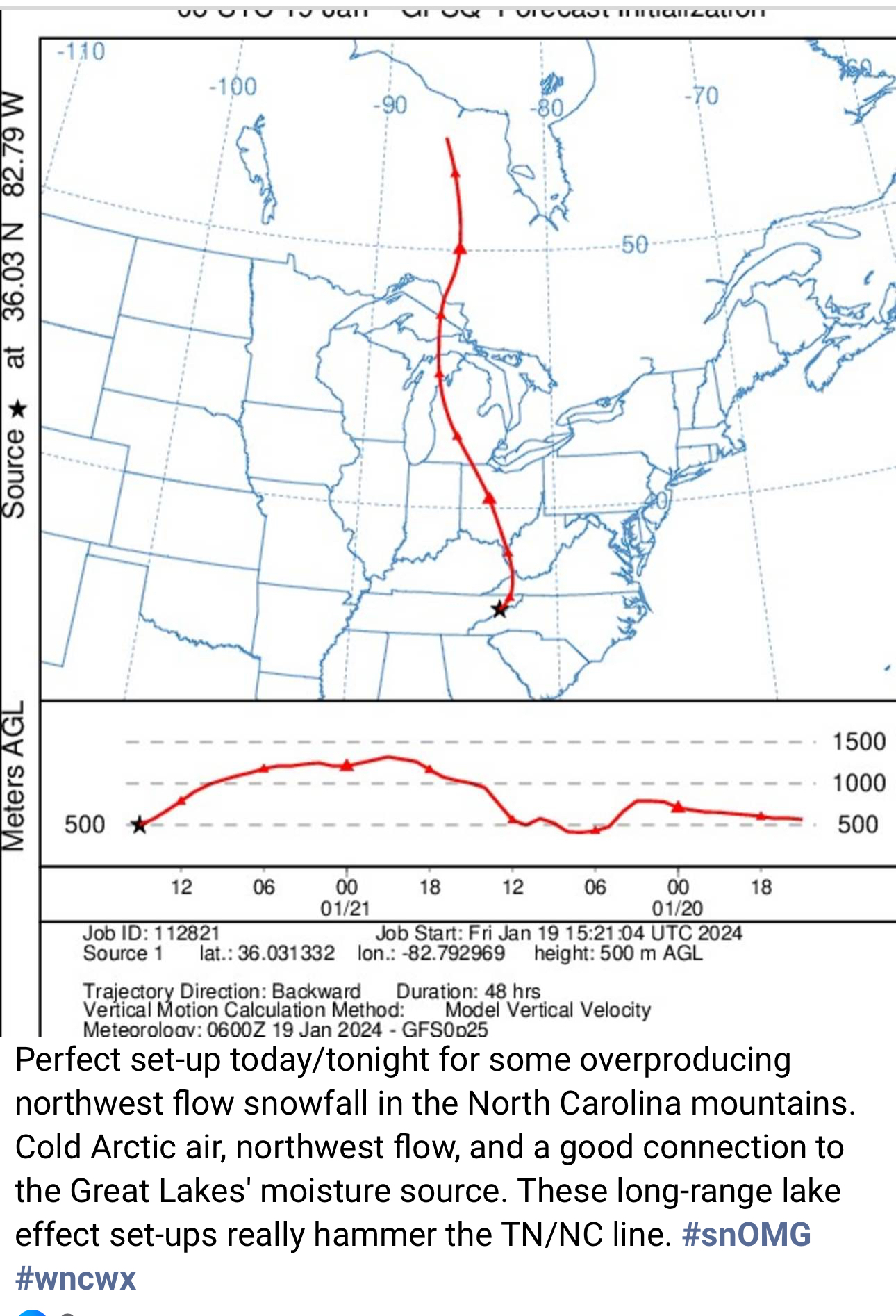
The source area for todays cold advection and moisture flow -
2023-2024 Fall/Winter Mountain Thread
nchighcountrywx replied to The Alchemist's topic in Southeastern States
-
2023-2024 Fall/Winter Mountain Thread
nchighcountrywx replied to The Alchemist's topic in Southeastern States

-
2023-2024 Fall/Winter Mountain Thread
nchighcountrywx replied to The Alchemist's topic in Southeastern States

-
2023-2024 Fall/Winter Mountain Thread
nchighcountrywx replied to The Alchemist's topic in Southeastern States
-
2023-2024 Fall/Winter Mountain Thread
nchighcountrywx replied to The Alchemist's topic in Southeastern States
GSP Morning AFD Discussion 01/04/24 300am The aforementioned low-level jet will establish a pronounced warm nose across the area before the column fully saturates with the warm nose strongest across eastern portions of the area. Wetbulbing via saturation of the dry airmass will help establish an in-situ wedge of cold air east of the mountains. Sub-freezing wetbulb temperatures will be common at precipitation onset from the mountains through the North Carolina foothills and Piedmont, especially deeper into the wedge along and north of I-40. Thus, a mixed bag of precipitation types is expected Friday night into Saturday morning. A brief period of snow is expected across the mountains before the strengthening warm nose switches things over to sleet and then freezing rain. Farther east, in the in-situ wedge, freezing rain will be the predominate precipitation type with a brief period of sleet possible across the northern foothills. Without a sustained source of cold dry air, and given the self limiting process of freezing rain due to latent heat release, all locations will eventually see surface temperatures warm above freezing. This will occur quickest on the edges of the in-situ wedge with the northern foothills and mountains the last to see temperatures rise above freezing late Saturday morning. Pretty much everyone should be seeing a cold rain by noon, if not earlier. The question now turns to how much snow/sleet/ice accumulation can be expected. The quick transition to ice across the mountains will limit snow/sleet totals to 1-2" followed by 0.05-0.2" of ice. In the in-situ wedge, marginal wetbulb temperatures and light winds will lead to modest ice accretion at best with most places on the edge of the wedge seeing a lot of runoff and less freezing of the rain. A few hundreths of an inch of accretion will be possible along I-85 before quickly warming above freezing with roughly 0.1-0.2" along a line from Statesville to Hickory to Rutherfordton and Columbus. Historically, even during in-situ wedge regimes, the foothills immediately against the Blue Ridge escarpment, especially along and north of I-40 tend to hold on to sub-freezing air the longest and have proven to be stubborn to warm. Guidance often struggles to resolve this with the NAM often having the best handle on low-level thermal profiles in wedge airmasses. Thus, more weight was given towards the NAM thermal profiles, which supports a longer duration of freezing rain against the escarpment. In addition to climatological support, probabilistic guidance also paints this area as the location most likely to have the potential to receive warning criteria ice accretion. As such, a winter storm watch has been hoisted from Alexander/Caldwell counties southwest along the escarpment through Henderson and the mountains of Polk county. The highest ice totals are expected to occur in this corridor from Lenoir to Marion to Lake Lure and Hendersonville. Eventually, winter weather advisories will be needed across the surrounding counties where ice accretion is expected. Two limiting factors that could result in less ice would be temperatures warming quicker than currently forecast and the potential for deep convection along the Gulf Coast to inhibit greater inland moisture transport and reduce available QPF. A period of northwest flow snow showers will also be possible along the Tennessee border Saturday night