SnowGoose69
-
Posts
16,752 -
Joined
-
Last visited
Content Type
Profiles
Blogs
Forums
American Weather
Media Demo
Store
Gallery
Everything posted by SnowGoose69
-
The EPS was definitely north with the anafrontal event so maybe that one still happens at least
-
The funniest thing about this Euro run is it was also the crappiest with the anafrontal snow too so it was two shots at us lol
-
January 20-22 “bring the mojo” winter storm threat
SnowGoose69 replied to lilj4425's topic in Southeastern States
You won't see it there...its visible on the surface maps with much colder thicknesses and 850 temps into TX/LA/AR vs the GFS -
January 20-22 “bring the mojo” winter storm threat
SnowGoose69 replied to lilj4425's topic in Southeastern States
The GFS push and overall air mass is markedly warmer across the Gulf/SE than the Euro too...the Euro at 90 has a massive supply of cold air back into the TN Valley whereas the GFS scenario if you amp the wave more many areas in the E Gulf Coast would see rain. Its odd seeing the GFS be the less cold model or at least have a less cold high pressure dome -
At 78 the GFS is more amped in the Gulf Coast but its not going to come all the way this run
-
Yeah but this is the exact type of event it always botches...anytime you're dealing with trying to eject a S/W out of Texas or the Gulf in a pressing arctic air mass the GFS buries the wave in Mexico or the Gulf
-
I never trust the CMC/GFS is these scenarios with the arctic high elongated down into the Gulf when you're relying on some sort ejecting wave...they are predominantly better models with northern stream systems. The Euro almost always ends up winning these in this range, even during its years of sucking recently after that upgrade
-
And the EPS has it mostly as an inland snow event LOL. So much for that prediction by me
-
Will have to see the EPS but that is a pretty classic SRN US/MA snow setup at 140-170....and also its fairly common to see a few Op runs or even ensembles lose those sort of events at this range because they bury the shortwave in the Gulf. I would not be shocked at all if this makes a comeback and I think it does but I'd favor the SE US and SRN MA for now
-
Would not be surprised if we see NYC get an inch with this and LGA/JFK see nothing.
-
It tends to be too cold in mid-level WAA situations. Especially beyond 6 or 8 hours
-
The 18Z NAM has .18 snow at ATL. Definitely need to watch 17-00Z tomorrow. I would only forecast around an inch or so now but there is risk for as much as 3 I think if there is more organized snow behind the upper low.
-
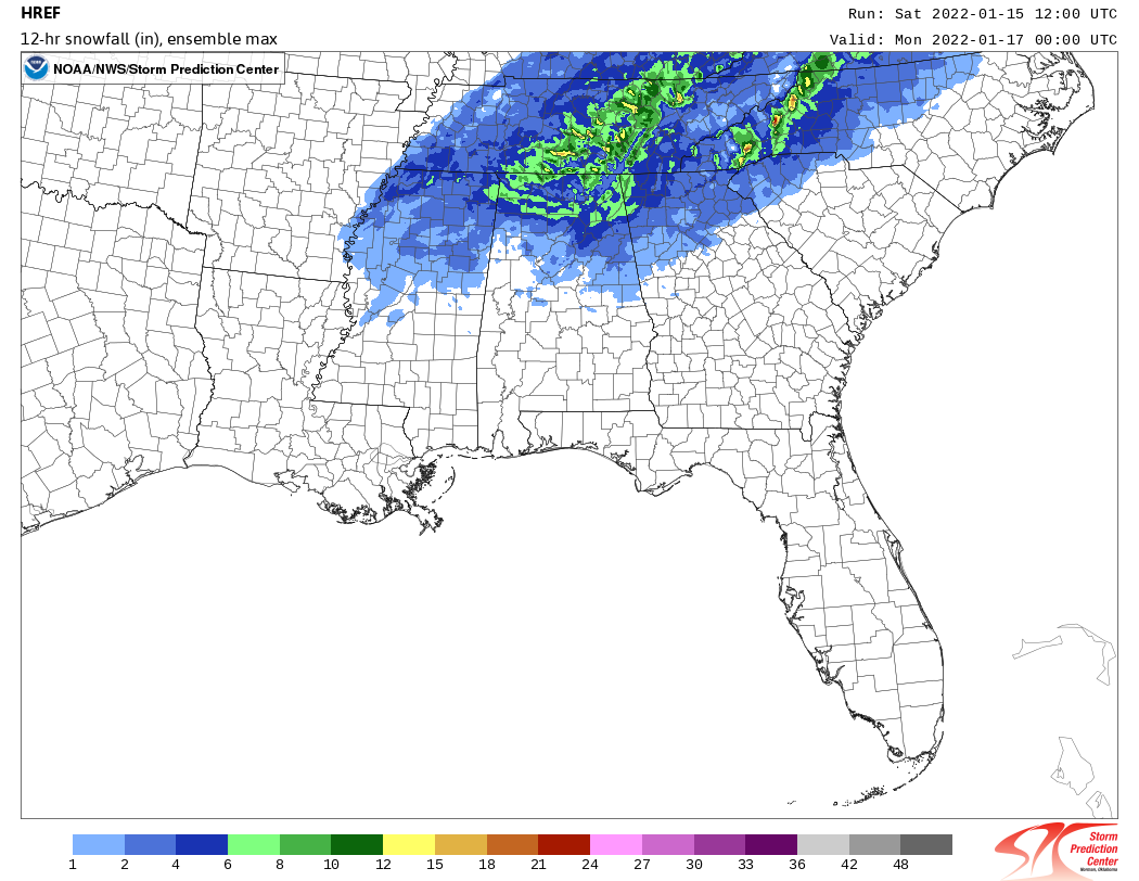
This is the ensemble max

-
One thing is for sure...the SPC HiRES is not impressed with snow at all in Upstate SC except right along the NC border in the far N. It also shows potential for big snows on the ensemble max across most of NRN AL/Cntrl TN and far NW GA showing risk of 6-10. The mean itself is fairly low everywhere. I am not sure how well it does in SRN snow events but it does well in the Northeast.
-
The difference in February with a raging -PNA and -AO/NAO is that due to wavelength change the pattern would be markedly different than Dec...you would never have a massive SER in February or March under those same conditions
-
Both the 12Z RGEM and NAM now show a more solidified and organized area of snow behind the 500 low over ERN AL and NRN GA...it never made sense to me how disorganized and showery it was looking yesterday but models even in 2022 tend to struggle with precip intensity and coverage behind closed 500 lows in the SRN US because typically the surface feature is not yet well developed or is weak. They'll never underestimate those parameters in New England or the Great Lakes because often times by then the surface low is deep and organized and the system is more mature. I think places like Rome on east could see several inches.
-
ATL seems to have expanded the watch a bit SW but did not upgrade to warnings anywhere
-
I noticed when checking analogs for areas from SC back across GA/AL there are no great matches really. All cases where the low was closed or semi closed the cold air source with the 500 low was way less...there were not expansive sub 0C 850s as there are in this case. 12/9/89 and 2/26/04 were the closest examples with 12/9/89 being closest but the 500 low was fairly open
-
The GFS never does well with thermals in a wedge setup or a setup with a 500 low significantly lowering temps and in this instance we have both taking place in a span of 36 hours where you are. It'll only handle these setups well in a case where the cold is extreme and even then its too warm. The 2/2013 ice event in the SE the GFS did okay because the wedge was so extreme it could not miss it
-
Largely inconsistent. You never know which events its going to do well and which it wont
-
I wouldn’t be shocked at all it NRN-CNTRL MS AL GA see fairly significant snows. That upper low is fairly strong. You don’t usually see a 500 low that strong without fairly significant snow somewhere. The NAM does show snows wrapping behind it but at this time it’s very light
-
The issue is solely at the surface for the coast (as far as the first 6 hours anyway)...18Z Euro is not bad aloft 00-06z Sun night/Mon AM but with 090-100 15-20kts you'd probably get 34-35 at a depth of 2000 feet and rain...if...if that high is slower or the models are not seeing somewhat of a wedging impact yet and the winds are more 060-80 there could be 2-3 inches at the coast...especially NYC proper
-
Probably Sullivan County NY like Liberty/Monticello. Certainly could do High Point/Port Jervis/NERN Wayne Co PA as well. If we get more of a west shift of mid-level lows though might need to be closer to BGM
-
The strangest thing about this event is how BWI/DCA get way more snow than NYC. I don't recall if I ever saw that before in such a setup
-
It seems to me historically 70% of ATL snow events are weak gulf lows, 20% stronger upper lows and 10% coastals that develop in SE GA or SC like 1/22/87 as I mentioned yesterday. I still lean towards it being unlikely they see significant snow unless either the primary and 500 trof digs way more over MS/AL or the transfer to the coastal is earlier