wdrag
-
Posts
5,603 -
Joined
-
Last visited
Content Type
Profiles
Blogs
Forums
American Weather
Media Demo
Store
Gallery
Everything posted by wdrag
-
Wantage NJ--- this part of, only 1.10.
-
All comments agreed... I am a little leery of the sounding but I erred on the side of caution mainly cause of EPS wind gusts and wet ground. Sometimes the EPS is 5 MPH too high and concerned the 12z HRRR itself as well as 06z NAM just not quite there. 06z FOUS BL wind 26 KT at KLGA which is just below my criteria for alerting wind advisory. 1 knot below is possible modeling error so it can happen but if it doesn't, then many models had us just below. anyway, caution advised this afternoon and a beneficial call.
-
NWS posted yesterday afternoon... its sort of marginal so I waited. Still looks marginal to me but err on the safety and will await your reports. I'll be offline til 9PM tonight. I am finishing up a summary post for yesterdays beneficial rain. It should. be out in 15 minutes.
-
I just checked the 06z/31 NAM/3K NAM, RAP and RRFS and all do not have max wind gusts 45+. So we should look back on model performance later today.
-
I just checked the 09z/31 HRRR and it doesn't forecast 45+ MPH for our area today except ridges/water. Maintain NWS messaging. I do think there will be a few gusts 40-44kt (46MPH+) so the conservative guidance is that... I can live with the 00z/31 SPC HREF MIN gust tool and the EPS MAX Gust tool.
-
I'll have a wrap up post around 930A inclusive of two day CoCoRaHs and one or two other graphics regarding predictability (the 1+"/ 30 min rainfall was not predictable in my opinion except short fuse warning).
-
If a moderator can pin the new thread topic. Thank you. Guidance has us marginal wind advisory criteria... my greatest concern is fully leaved trees in the rain softened ground toppling (after yesterdays wide spread 1.5-2.5" rainfall. OBS for Halloween 2025 afternoon-evening scattered gusts 45+MPH w a few damage power outage reports from limbs/trees down
-
Follow and. further NWS updated advisory statements and possible police detours. Now that yesterdays has passed, backside wind gusts will be increasing to 40 MPH throughout the area this afternoon, with scattered or isolated gusts to 50 MPH breaking a few tree limbs and even causing rain softened ground to permit fully leaved trees to possibly topple. This would be life threatening to those unfortunately in the path of limbs breaking. Be aware of possible detours and delays this afternoon-evening. Air travel continues to be impacted, especially Noon to near midnight with certainly delays, and probably some cancels. Using the 00z/31 EPS max wind gust tool, max gusts are anticipated to be 45-50 MPH with the SPC HREF Fire MINIMUM wind gust tool offering at a minimum, near 40MPH gusts on land, except 50 MPH one the ridges and of course on the water. I do not have access to other sounding wind gust tools. 714A/31
-
Another band of showers, some very briefly mdt-havy for NNJ-NYC NYS this eve as the 5H sort-trough axis and about 150M 12 hr Height Fall Center axis passes through, then the sfc wind turns west and drying begins with gusts 40 MPH tomorrow afternoon ,. As of now not planning a new thread for marginal wind alone tomorrow. I think today will have equaled or exceeded what ever tomorrow brings.
- 246 replies
-
- 4
-

-

-
- heavy rain
- damaging wind? squalls?
- (and 2 more)
-
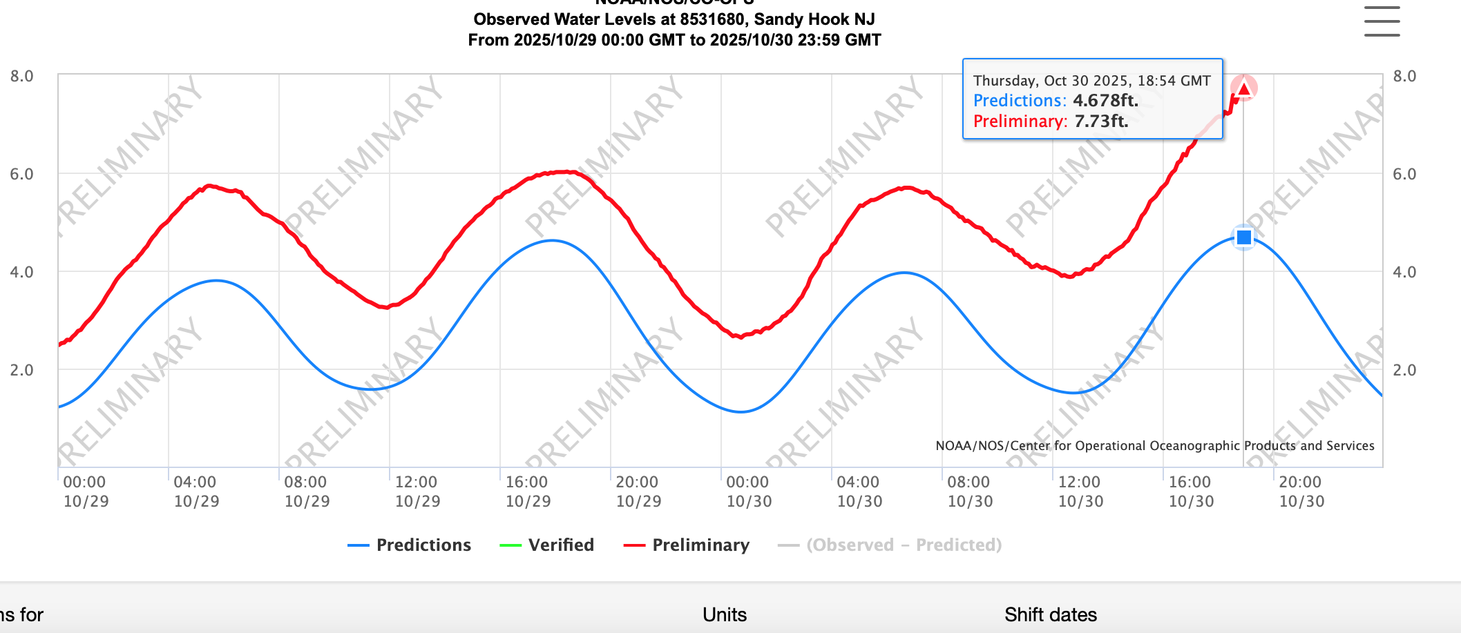
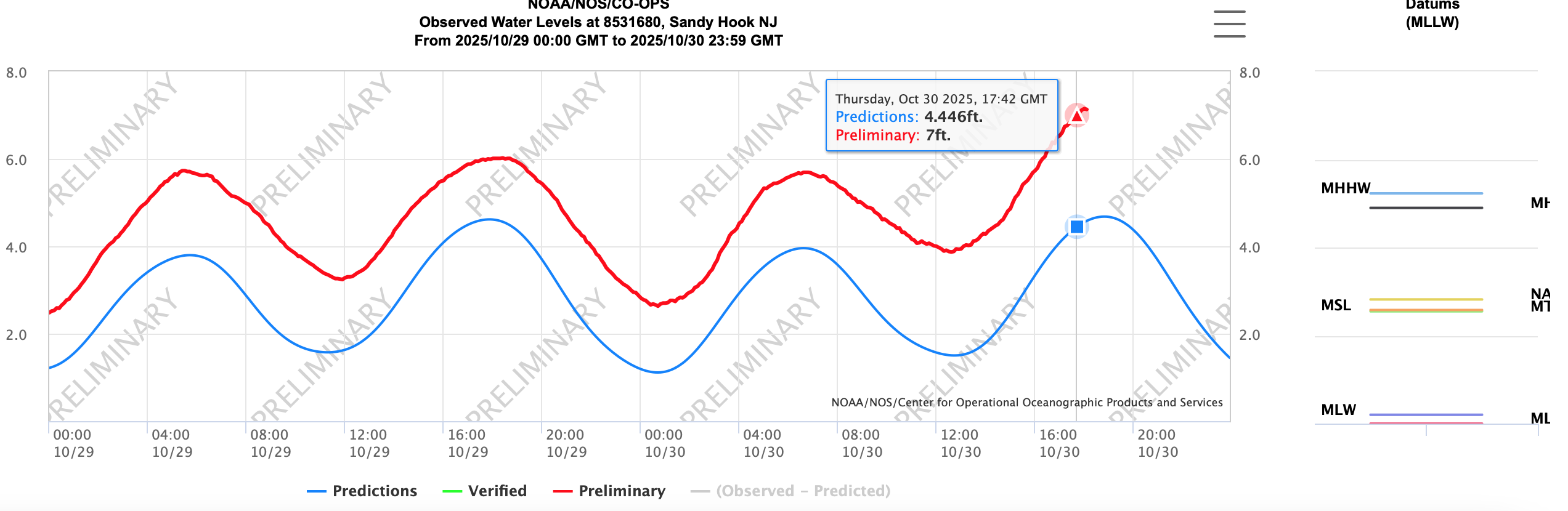
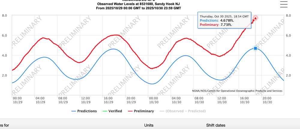
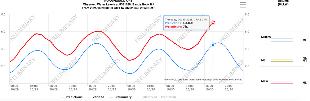
Sandy Hook briefly leveled at Moderate flood level 7.7' MLLW a few minutes ago. a 3' surge due to lowered pressure and timing of max gust 50 MPH inflow.
- 246 replies
-
- 2
-
-
- heavy rain
- damaging wind? squalls?
- (and 2 more)
-
NOT overperforming... performing very close as modeled 5-6 days ago.
- 246 replies
-
- 8
-
-
- heavy rain
- damaging wind? squalls?
- (and 2 more)
-
Rainfall 1-2" in NJ except Sussex County and a few spots on the coast 3/4-1". NYC around 0.8 so far except about 1.5 Staten Island.
- 246 replies
-
- 1
-
-
- heavy rain
- damaging wind? squalls?
- (and 2 more)
-
I will post a general modeling summary after this event is over going back to the original guidance available Sunday and from CPC a week ago. Initial lessons: GFS max wind gusts too light with EC and NAM gusts better. Let's remember for the future on easterly wind events.
- 246 replies
-
- 1
-
-
- heavy rain
- damaging wind? squalls?
- (and 2 more)
-
Max gust on NYS mesonet sites about 5-8 MPH less than ASOS max gusts. Officially minor flood at Sandy Hook. FS 6.7". they are at 7.15 bobbing around and may go up and bother 0.3' through there high tide cycle now. Attached... Also 10-13,000 meters without power now in all three states of NJ, NY, PA. Wind related.
-
Widespread Gusts on ASOS NYC metro airports 40-46 KT past couple of hours.
- 246 replies
-
- 2
-
-
- heavy rain
- damaging wind? squalls?
- (and 2 more)
-
saw Staten Island NYS mesonet 0.90. At least one major NYC TV station is behind the reality
- 246 replies
-
- 1
-
-
- heavy rain
- damaging wind? squalls?
- (and 2 more)
-
NWS PHI recently upgraded the advisory to a Coastal Flood Warning for Ocean County-moderate flooding.
-
KFRG: Farmingdale, Republic Airport, NY, United States [44kt, 23m/s] KJFK: JFK Intl Arpt, NY, United States [46kt, 24m/s] KNEL: Lakehurst, NJ, 44 kt
-
Apparent storm damage on TV in the Bronx. 1200 meters out on Staten Island. now is the time for 45 MPH+ wind gusts n our area...next 5 hours; except later e Li.
- 246 replies
-
- 1
-
-
- heavy rain
- damaging wind? squalls?
- (and 2 more)
-
Thanks for your update and that matches the radar estimates. Brielle on the North shore of Ocean County NJ now G 52 Mph. winds increasing northward in NJ.
- 246 replies
-
- 1
-
-
- heavy rain
- damaging wind? squalls?
- (and 2 more)
-
1/2"/hr n-s stripe near PHL with lightning now. not sure where this will end up but should rock a bit this aft-eve in our area...even e LI later this eve.
-
Noting power outages increasing PA-NJ .. over 7000 in NJ and some of it seems high terrain, esp ne PA.
-
really... very nice. Maybe you head for 2.5". Thinking some spots in our forum I95 westward 3-3.5" in 9 hours soon.
- 246 replies
-
- 2
-
-
-
- heavy rain
- damaging wind? squalls?
- (and 2 more)
-
Lakehurst (KNEL) 51 MPH right now at about 1031A. Coming north imo