wdrag
-
Posts
5,603 -
Joined
-
Last visited
Content Type
Profiles
Blogs
Forums
American Weather
Media Demo
Store
Gallery
Everything posted by wdrag
-
Wind now starting as modeled by the EC KBWI: Baltimore, MD, United States [41kt, 21m/s] KILG: Wilmington, New Castle County Airport, DE, United States [41kt, 21m/s]] KLNS: Lancaster, Lancaster Airport, PA, United States [40kt, 21m/s] saw max gust 46 MPH (40 kt) adjacent DE Bay s NJ. soon should spread north.
-
Thanks for all the reports... keep em coming. Radarscope my favorite radar app...green heavier rates..maybe some of you will get brief 0.1" though probably not due to above freezing temps. Most of my snow has melted.
-
KJRB: Manhattan/Wall Street Heliport, NY, United States [43kt, 22m/s] KRSP: Campd David, MD, United States [49kt, 25m/s] Within the past couple hours. Heliport elevated but the idea is there. Supports the Queens ob of 45 MPH (39kt)
-
39KT on NYS Mesonet Queens now.
-
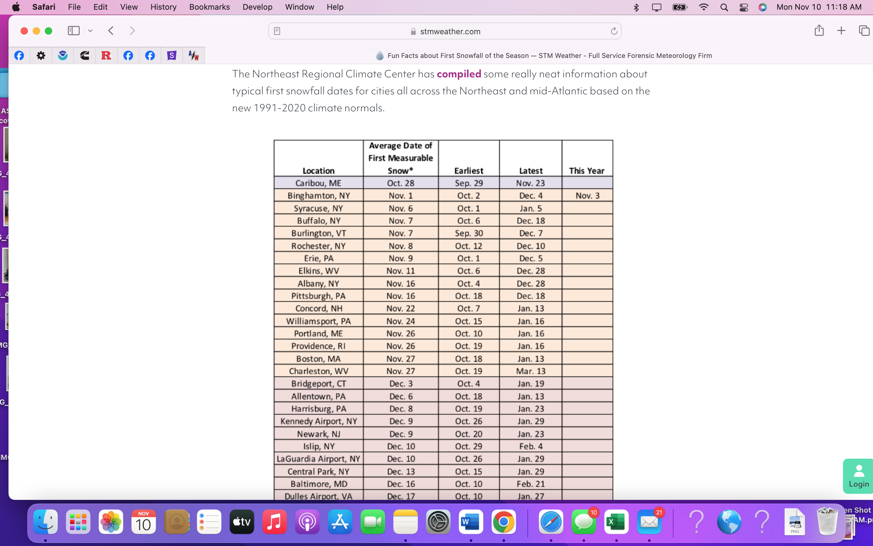
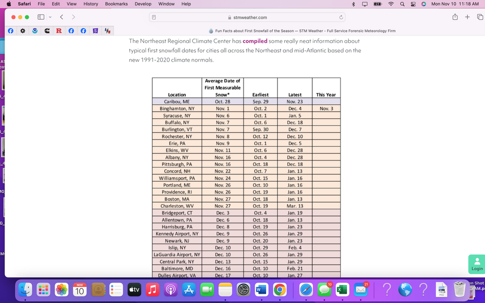
Majority of ASOS's LI and nw NJ have had their first flurries between 7 and 9A. Not sure of mean first date of T. I thought it used to be in the LCD. Can't seem to get XMACIS to look at Trace or greater, first-last date. Minor so unless someone adds, will let it go. I'll take it as a positive.
-
JFK and LGA first flurries of the season between 711A-739A. I am unsure of what the normal first date of Trace. A big hand for ECMWF and HRRR on this one.
-
Keep em coming... more snow this morning, maybe a heavier burst for NYC than what has already occurred.
-
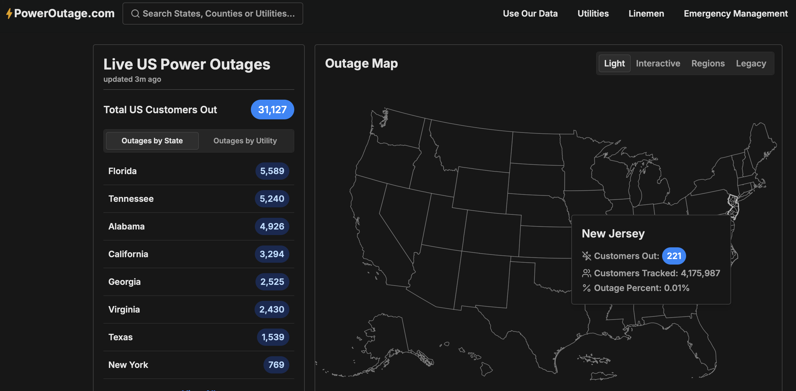
Thanks for the obs... snow today NYC metro mainly before 2PM if its to occur. Wind gust tools too low throughout the NYC forum. Trying to avoid being wrong, but I expect gusts to reach 40 knots at least at some I95 corridor ASOS's this afternoon PHL-NYC-BDR. Gusts already higher than Blend Of Models and all tools. This is an anomalously strong trough passage. I add the power outage map from 625AM as a baseline check to look back at 4PM today to see if anything happened. I don't like crying wolf but I am a fan of the ECMWF wind gust tool and secondarily all other tools. The secondary's are all lower. I prepare for a buffeting this afternoon and possibly a downed tree branch-power outage.

-
We do know Vernon NJ has measurable melted snowfall last 3 hours per the NJ Climate network. Also Roanoke 41 KT recently. snow showers and wind coming for at least some in our NYC subforum.
-
These snow obs should be going on the specific thread for today. Thanks
-
Wantage NJ 4sw: 515A 0.2" and 27F... snow starting to stick on driveway. Steady light snow in progress. Walt
-
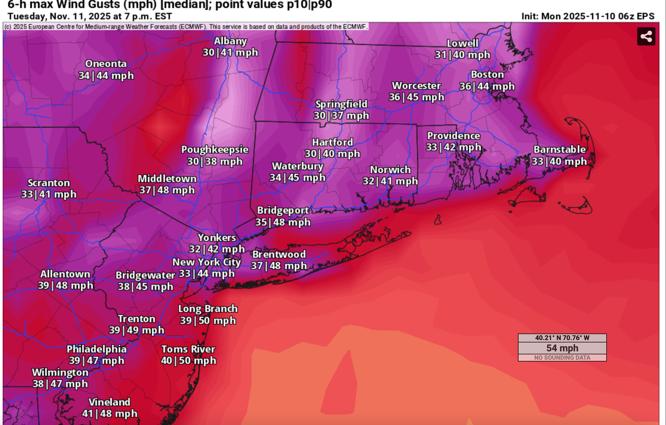
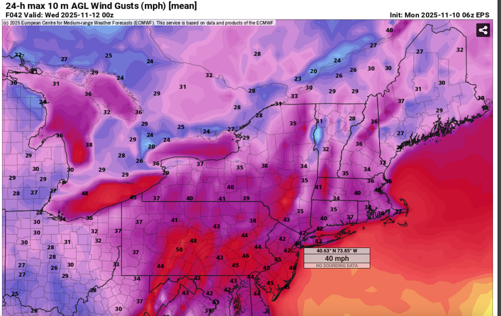
18z/10 ECMWF op says prepare for flurries tomorrow and gusts to at least 45 MPH parts of our area with power outages, esp NJ/PA/e LI. 40KT gust ATL recently, best fit 18z ECMWF. All other models a bit more conservative.
-
For fun, since we have modeled guidance posts the past several days of a deep highly anomalous cold unstable trough passage Tuesday. Momentum transfer via the NAM FOUS BL Wind hreshold of 27 kt and the Richardson Number as viewed on Bob Harts web pages, suggests winds do not exceed 45 MPH . However ECMWF EPS suggests marginal gusts 45-50 MPH southern part of the NYC subforum midday spreading into the NYC-Long Island and ridges above 1000 feet late in the day or evening. Impact mainly air travel and possibly isolated or scattered broken branches impeding traffic here and there. Of greater interest to the NYC subforum is the likelihood of flurries or even scattered light snow showers moving across the forum area including NYC-Li midday-afternoon. Could this be CP's first trace of snow for the 25-26 winter? 06z/10 EPS range via prob 10% (high gust) and 90% (low gust) 06z/10 median wind gust (marginal) and First measurable snow history Posted fina 1218PM/10 (0718z/10

-
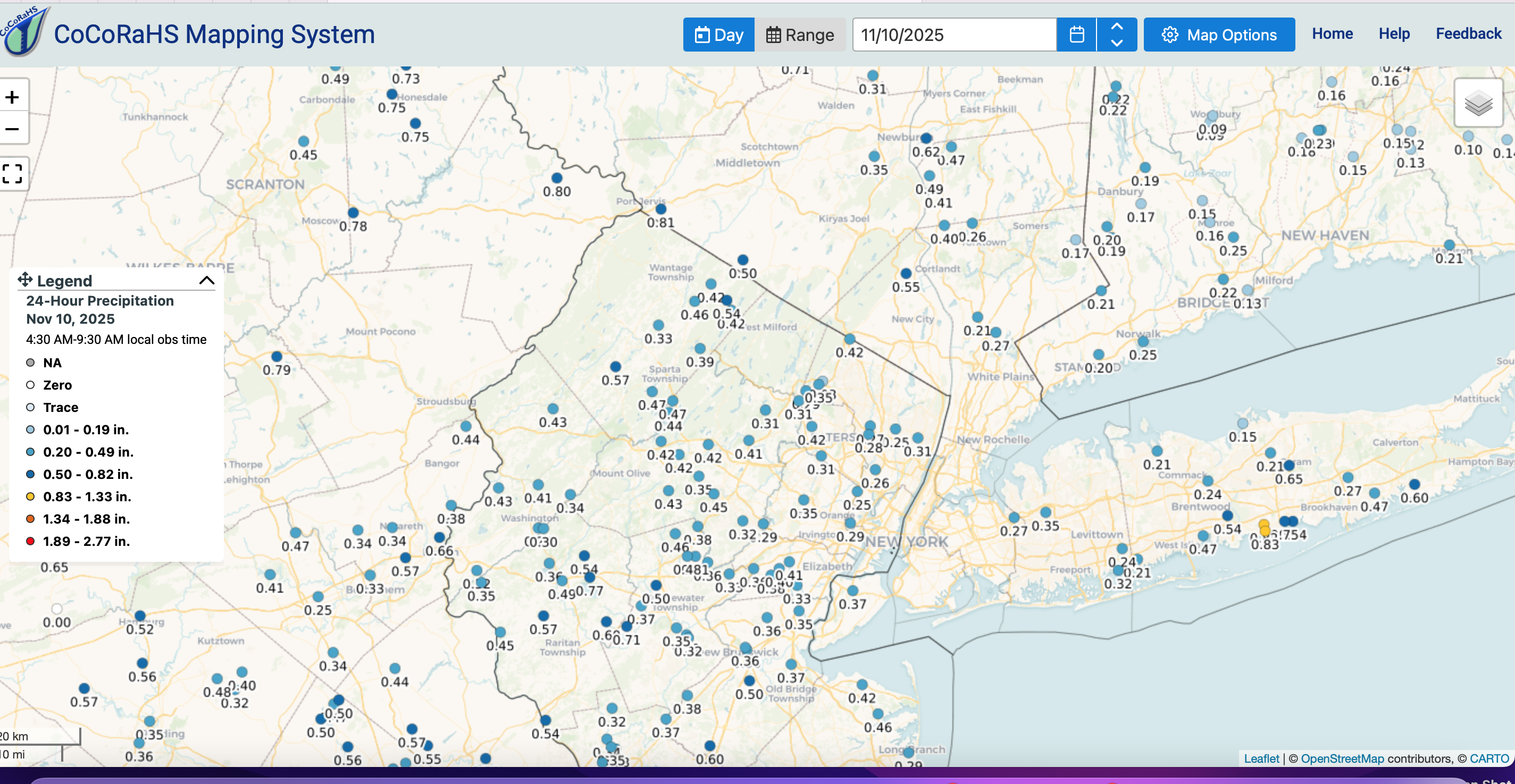
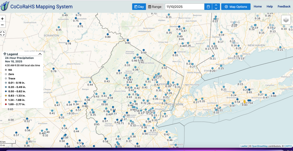
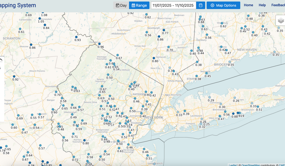
I'll possibly thread tomorrows 45MPH+ wind gusts and flurries, this afternoon. In the meantime... more rain coming to NYC and parts of NJ shortly. Here's the past 24 hour amounts and amounts since Fri. Click for clarity.
-
This big block in e Canada-Greenland I think is going to yield an equally pretty big storm response(s?) by Thanksgiving.
-
Monitor whats going on in the Delmarva -I95 corridor... VERY sharp trough developing eastern USA. WPC D1 from this afternoon mirrored the SPC HREF D1... looks too low in my NOWcast mode as I look at the radar and multiple models. Am looking for 1/4-3/4" for much of the subforum by Noon tomorrow between 7P tonight and Noon Monday. This past Fri-through Noon Monday should see 0.3-1.25" for the 4 day period by the time we look at CoCoRaHs range of dates.
-
Monitor but dont take the bait...once cycle and EPS has nil. Probably a tease but with the block as it is possibilities will present, but will they ever express as reality this month?
-
No thread attm for 1) the Tue wind advisory potential 10A-10P (marginal since the 850 jet doesn't increase past 40 kt til near sunset) and 2) the first flakes of the season at NYC CP ASOS...again hit or miss during Tue morning-early afternoon. Flurries are coming in the exceptionally unstable low level lapse rate to 750MB -momentum transfer from roughly down below 9000' (-12C 850 temp ANOMALY for this early in the season)..therefore mixing near 40 kt, especially late Tuesday and spewing virga/sct flurries/sprinkles into NYC with the BL temp a little too warm to be assured flurries at the CP ASOS but I think it will happen. This in association with the northeast departing 12hr 190M 5H HFallC and the oncoming 210M 5H HRiseC. IE... a high amplitude cold trough aloft getting ready to quickly exit the northeast USA. I saw the CFS comment a couple days ago about multi consecutive snow cycles for the interior NYC subforum tomorrow. I'm not a CFS fan and so I dont look at it very often. I did pay attention to the comment. It's a climate model so I doubt if it has the BL temp handled as well as the standard Global EC/GFS/ECAI. Even the ECAI still lags all other modeling and looks hopeful for cold rain into early Monday afternoon across most of the NYC subforum, but it looks like the BL temp is too warm for wet snow melting on pavement except maybe our nw NJ hills into the Catskills during the midday-afternoon hours, above 1000 feet. Fairly interesting pattern for Nov given the return of the strong 5H Block to eastern Canada-Greenland.
-
for what its worth the low tide early this morning was -1.77 feet MLLW at Sandy Hook, nudging the threshold for low water advisory there. Not sure what impact this had?
-
Somewhat interesting next Tue: the third near 200M amplifying 5H HFC in the eastern USA for the period 10/30-11/11. This time it amplifies too late and too far northeast - about 200M near Eastport Maine on the 11th. May result in our first flurries and more certainly another 45+MPH wind event (with less leaves to act as sails). Today is the 6th. No thread, if ever any, til at least this Saturday. Need modeling to agree more wind etc.
-
i wonder (for prior typo) why this wasnt published separately... in other 390' MSL is different than ~35' MSL (ASOS). I feel the same way about the High Point Monument NJ wind speeds... it's an idea above crown height but not very good ground truth.
-
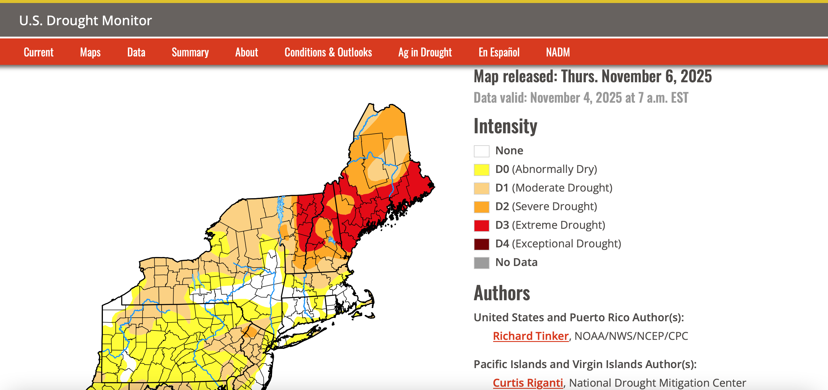
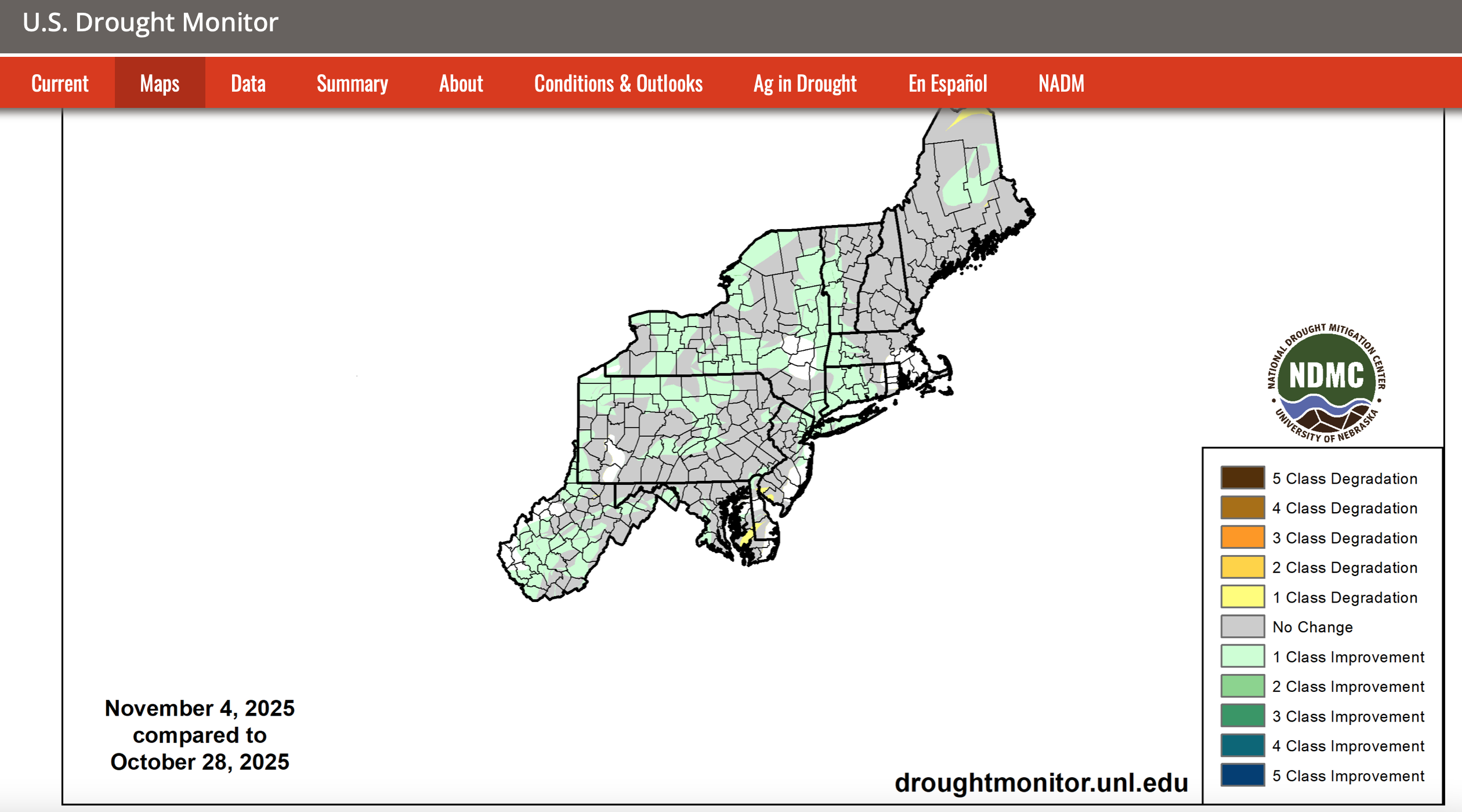
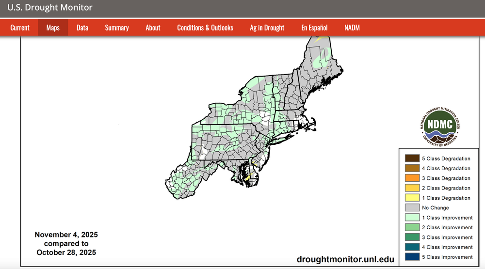
Drought monitor and the classification change over the past week attached. Please click for clarity.

-
Formidable repeatable block N Canada-Greenland to persist into the week before Thanks giving (at least the 20th). Going to be interesting. Was all this blocking modeled beyond two weeks in advance? I like the cool season start UA pattern. Can't rule out first T of mixed r-s shower CP around next Tuesday as a very sharp trough exits. Probably wont happen but am sure of first flurries much of the I84 corridor this coming Monday-Tuesday, with low power prob some light grassy accums. Another wind event modeled- suggested later next week or weekend.
-
Leftover power outages at 8AM today after the late Wed eve-early Thu wind event. Pennsylvania45,455 New Jersey12,254 Maryland4,677 New York3,653
-
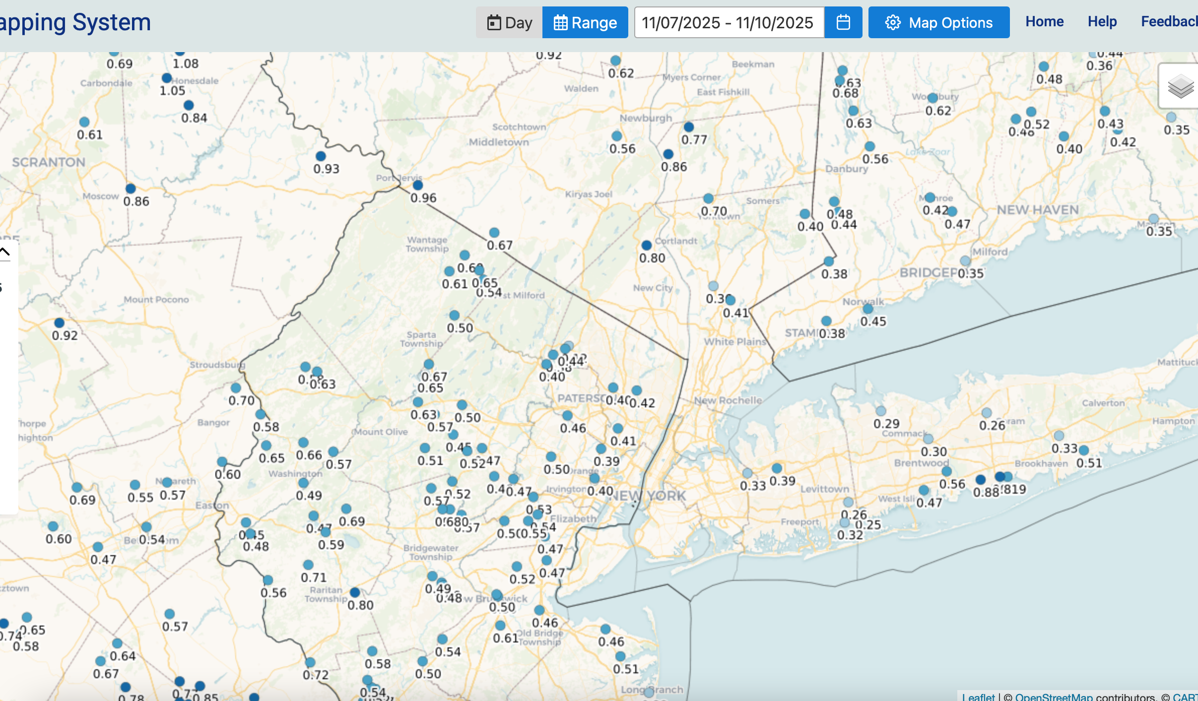
Much thanks for this OKX wind report. I'll close that these reports verified the advisory.