donsutherland1
-
Posts
23,761 -
Joined
Content Type
Profiles
Blogs
Forums
American Weather
Media Demo
Store
Gallery
Everything posted by donsutherland1
-
It’s unfortunate that they don’t verify their numbers before going on air. It is not a difficult task.
-
2025-2026 ENSO
donsutherland1 replied to 40/70 Benchmark's topic in Weather Forecasting and Discussion
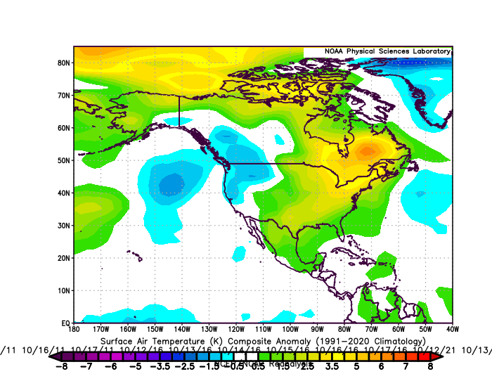
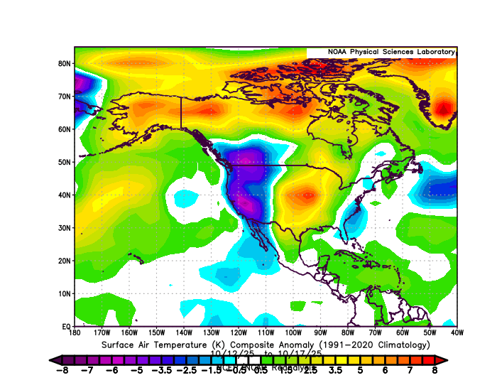
Analogs, because they are derived from boundary conditions, do not capture synoptic details. Thus, very short timeframes aren't great for assessing them. Periods of 1-3 months provide greater assessment value, as things essentially average out from a series of synoptic events. In theory, the better analogs should come up with a reasonable but not perfect approximation of the 1-3 month period. As North American data is available for October 12-17, I used that to make some comparisons: 2013-2024 Composite: 2011-2016-2021 Experimental Statistically-Generated Cases (discussed earlier in this thread): Actual: October 12-17, 2025: Overall, the actual 2025 data is more amplified than the composite analog cases, aside from spatial differences e.g., misaligned areas of cold and warm anomalies. These kind of differences are to be expected at the very short timeframes used, as synoptic details outweigh boundary conditions at such timeframes. If there is value in either set of analogs, that would become evident over the longer periods of time where boundary conditions outweigh synoptic details.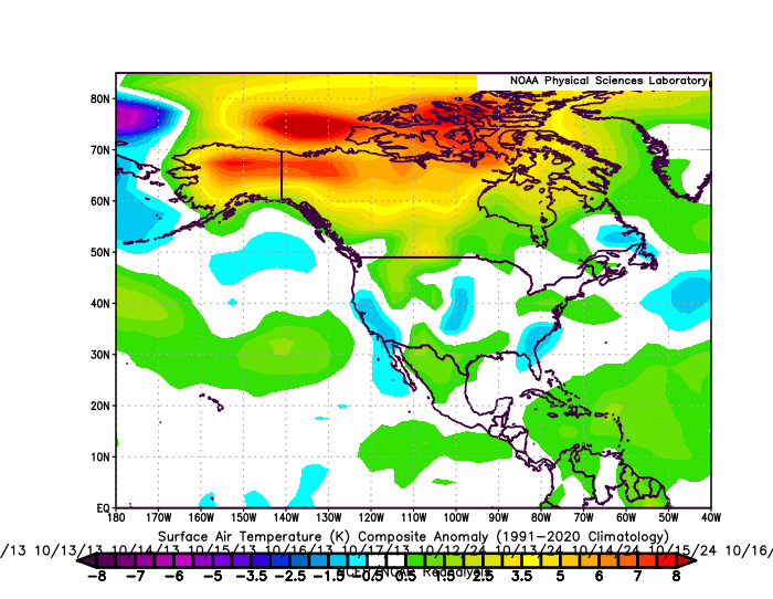
-
Under mostly sunny skies, much of the region saw temperatures reach or exceed 70° today. Highs included: Atlantic City: 72° Bridgeport: 70° Islip: 70° New Haven: 71° New York City-Central Park: 70° New York City-JFK Airport: 70° New York City-LaGuardia Airport: 71° Newark: 73° Philadelphia: 77° A cold front will move across the region tonight into tomorrow morning. Low pressure will likely form along the front and move across the region. Periods of rain and perhaps some thunderstorms are likely into tomorrow. A period of severe weather is possible. A general 0.25"-0.75" rainfall with locally higher amounts appears likely. Following the frontal and storm passage, temperatures will top out in the lower and middle 60s through midweek. A stronger push of cold air could arrive afterward. Cool temperatures will likely persist through next weekend. The ENSO Region 1+2 anomaly was -0.1°C and the Region 3.4 anomaly was -0.3°C for the week centered around October 8. For the past six weeks, the ENSO Region 1+2 anomaly has averaged -0.12°C and the ENSO Region 3.4 anomaly has averaged -0.42°C. La Niña conditions will likely continue through mid-winter. The SOI was +7.60 today. The preliminary Arctic Oscillation (AO) was -0.919 today. Based on sensitivity analysis applied to the latest guidance, there is an implied 63% probability that New York City will have a warmer than normal October (1991-2020 normal). October will likely finish with a mean temperature near 58.5° (0.6° above normal). Supplemental Information: The projected mean would be 1.6° above the 1981-2010 normal monthly value.
-
Yes, that seems to have been an exception, prominent as it was.
-
Occasional Thoughts on Climate Change
donsutherland1 replied to donsutherland1's topic in Climate Change
Yes, there are already some studies suggesting that it erodes critical thinking skills. That's a real problem. -
2025-2026 ENSO
donsutherland1 replied to 40/70 Benchmark's topic in Weather Forecasting and Discussion
This is another example why I call out hypesters such as Bamwx, et al., at times: Notice his claim about the Fall NAO vs. the Winter NAO. Most of his readers likely don't know that the NAO's values can be found here: https://www.cpc.ncep.noaa.gov/products/precip/CWlink/pna/norm.nao.monthly.b5001.current.ascii.table They take for granted what he says, especially as it might fit their winter preferences. But if one actually takes a look at the actual data, during 1950-2024, there were 38 cases where the fall NAO averaged < 0. From those cases, just 13 (around 34%) saw the winter NAO average < 0. So, almost the opposite of what he claims. That's a fact. It's not speculation. Hype, misleading information, and repeatedly low forecast verification from pushing extremes creates bad perceptions about the many meteorologists who do their best to provide the public with useful, actionable weather information.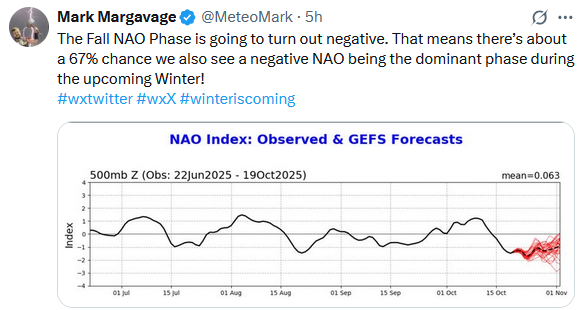
-
Occasional Thoughts on Climate Change
donsutherland1 replied to donsutherland1's topic in Climate Change
I used the same AI he used to illustrate a point. I still prefer using the actual literature. AI is here to stay, how it is used or misused will have profound consequences. I take no position on whether AGI or a “singularity” will be reached anytime soon. -
Far more likely, the potential tropical cyclone will approach or die as it heads toward Central America or flung NE/ENE out into the Atlantic. A lot would need to happen for the capture to play out. Models don’t have skill this far out on such details.
-
2025-2026 ENSO
donsutherland1 replied to 40/70 Benchmark's topic in Weather Forecasting and Discussion
FWIW, the top 3 QBO analogs regardless of any other variables e.g., ENSO, for the past three months are 1974, 2014, and 1979. 1974 ranks 3rd best over a wider 6-month period while 2014 ranks first over a wider 6-month period. 1979 is just 20th for a wider 6-month period. So, the 1974 and 2014 cases probably offer a reasonable picture on how the QBO will evolve over the next few months. -
2025-2026 ENSO
donsutherland1 replied to 40/70 Benchmark's topic in Weather Forecasting and Discussion
The QBO differences you point out are real. I am not sure why he grouped things as he did. -
Occasional Thoughts on Climate Change
donsutherland1 replied to donsutherland1's topic in Climate Change
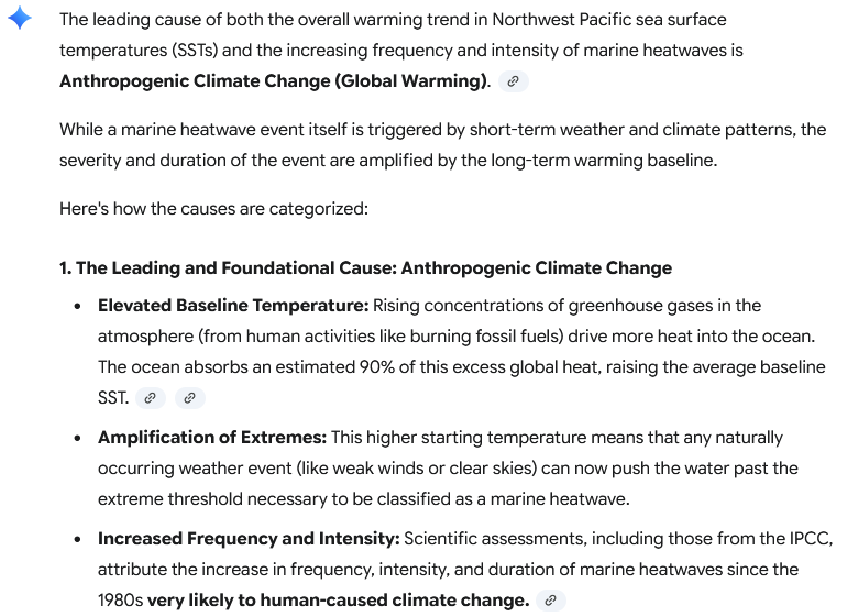
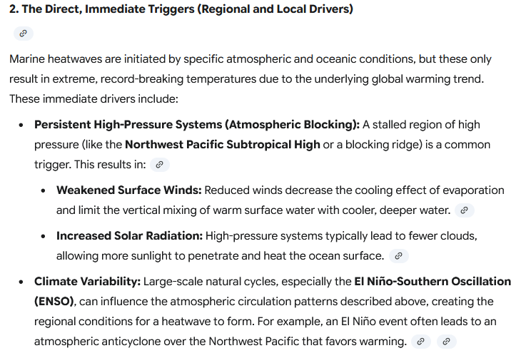
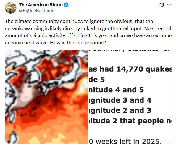
As I provided the SSTA data yesterday, I won't repeat that part of the post. I note that he asked GEMINI (AI) a question. The question he asked does not directly address the issue. The issue concerns whether volcanoes are driving the warming, not whether there is hydrothermal activity and/or what drives that hydrothermal activity. Since he used GEMINI, let's see how it would respond to a direct question (note: I never provided "leading" information to generate a desired outcome): Its response: So, while he tried to create the impression that AI, or at least one AI, backs his thinking, when asked directly about the warming, the AI does not. It focuses on what the literature describes as the causes of the warming. Submarine volcanoes are not even mentioned its response. Of course, he didn't ask the direct question. It doesn't fit his preferred outcome. The exercise was about confirming his view, not gaining objective information. Although the AI performed quite well with the direct question, I still think it is better practice to go to the literature itself, as bad practices such as prompt injection can lead to skewed results from AIs. A good paper on the subject can be found at: https://agupubs.onlinelibrary.wiley.com/doi/full/10.1029/2020GL090956
-
Occasional Thoughts on Climate Change
donsutherland1 replied to donsutherland1's topic in Climate Change
The following seems to describe their M.O.: 1) If presented by counterarguments, they largely ignore the counterarguments or, in infrequent cases of response, make broad claims that the arguments are incorrect, they shift goal posts, etc. 2) If presented with data and links to the data or scientific literature that anyone can access, that crosses a "red line." They seem to have a mortal fear about others having the ability to access the data or literature, perhaps because they know that their own view is hollow unsupported conjecture. Access to data is far more dangerous to their view than simple counterarguments. -
The operational ECMWF certainly does before bringing a captured tropical cyclone into Maine and then northwestward from there. The proverbial pieces could be available. It will be interesting to see if we wind up getting tropical-enhanced rainfall, even if just through a frontal passage.
-
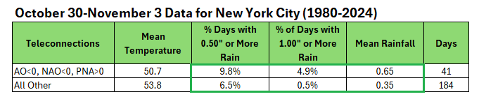
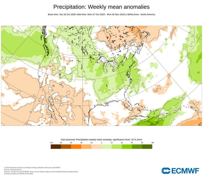
The latest teleconnection forecast calls for a negative AO, negative NAO, and positive PNA in the closing days of October and opening days of November. Such a combination can favor a period of wetter weather. The latest ECMWF weekly forecast for October 27-November 3 shows wet anomalies. It should be noted that the Week 2 CFSv2 anomalies are on the dry side of normal. Therefore, at least for now, the period merits watching, but there remains considerable uncertainty. I suspect that the odds are somewhat more in favor of the ECMWF outcome given historic outcomes, but that won't become clearer until the operational guidance moves into its high-skill forecasting range.
-
Occasional Thoughts on Climate Change
donsutherland1 replied to donsutherland1's topic in Climate Change
After he was corrected on the volcanoes issue with a link to a paper and data source showing warming at the upper and lower levels, he responded by blocking me. The description of the warming as being “top-down,” not “bottom-up,” as would have been the case were volcanoes involved, was too much for him. -
Occasional Thoughts on Climate Change
donsutherland1 replied to donsutherland1's topic in Climate Change
At the depths on this chart (< 2000 meters) they are very accurate. At greater depths a different float is used due to the limitations of the standard float. Here’s the description from the standard ARGO float description: The temperatures in the Argo profiles are accurate to ± 0.002°C and pressures are accurate to ± 2.4dbar. https://argo.ucsd.edu/faq/ -
Occasional Thoughts on Climate Change
donsutherland1 replied to donsutherland1's topic in Climate Change
Yes. Errors increase at greater depths. This data is reliable. -
Occasional Thoughts on Climate Change
donsutherland1 replied to donsutherland1's topic in Climate Change
More social media disinformation: The reality: Source of subsurface anomalies: CyclonicWx.com. I circled the depths and added the label to show what is occurring. were volcanoes responsible, SSTAs would be increasing at depth.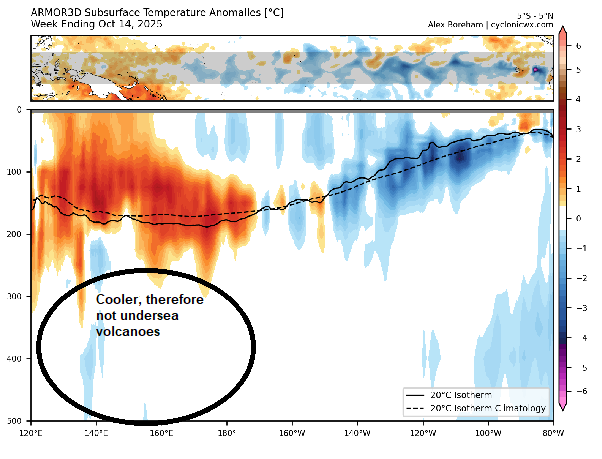
-
The weekend will end on a very mild note. Temperatures will reach upper 60s to perhaps lower 70s on Sunday. A cold front will move across the region tomorrow night. Low pressure will likely form along the front and move across the region. Periods of rain and perhaps some thunderstorms are likely into Monday. A general 0.25"-0.75" with locally higher amounts appears likely. Following the frontal and storm passage, temperatures will top out in the lower and middle 60s through midweek. A stronger push of cold air could arrive afterward. In the 18 past years where Central Park saw at least two 80° or above highs and Newark saw at least two 84° or above highs during the first week of October, the temperature returned to 70° or above on at least one day during the second half of October in 17 (94.4%) of those cases. For all other cases, 84.1% saw at least one such high temperature during the second half of October. Therefore, the sharp cool spell very likely won't mean that New York City has seen its last 70° or above high temperature. The ENSO Region 1+2 anomaly was -0.1°C and the Region 3.4 anomaly was -0.3°C for the week centered around October 8. For the past six weeks, the ENSO Region 1+2 anomaly has averaged -0.12°C and the ENSO Region 3.4 anomaly has averaged -0.42°C. La Niña conditions will likely continue through mid-winter. The SOI was +4.38 today. The preliminary Arctic Oscillation (AO) was -0.575 today. Based on sensitivity analysis applied to the latest guidance, there is an implied 63% probability that New York City will have a warmer than normal October (1991-2020 normal). October will likely finish with a mean temperature near 58.6° (0.7° above normal). Supplemental Information: The projected mean would be 1.7° above the 1981-2010 normal monthly value.
-
This morning is as good as it gets in October. The sun is bright and temperatures are pleasant.

-
Winter cancelled/uncancelled banter 25/26
donsutherland1 replied to Rjay's topic in New York City Metro
I put it here given the timeframe involved. If you feel it would be better in the October thread, please feel free to move it. -
2025-2026 ENSO
donsutherland1 replied to 40/70 Benchmark's topic in Weather Forecasting and Discussion
Yes. That's correct. During Winter 2012-2013, most of the Mid-Atlantic Region saw below normal snowfall. But southern New England saw much above normal snowfall, highlighted by a massive snowstorm during February 8-9, 2013. The snowstorm grazed parts of the northern Mid-Atlantic (Newark, Islip, New York City). Select seasonal amounts follow: Mid-Atlantic: Baltimore: 8.0" Philadelphia: 8.3" Washington, DC: 3.1" Northern Mid-Atlantic: Islip: 46.9" New York City: 26.1" Newark: 29.5" Southern New England: Boston: 63.4" Bridgeport: 64.3" Hartford: 56.9" Providence: 46.3" Here are the PNS reports for the February 8-9, 2013 Snowstorm: 818 NOUS41 KOKX 092015 PNSOKX CTZ005>012-NJZ002-004-006-103>108-NYZ067>075-078>081-176>179-100755- PUBLIC INFORMATION STATEMENT SPOTTER REPORTS NATIONAL WEATHER SERVICE NEW YORK NY 315 PM EST SAT FEB 09 2013 THE FOLLOWING ARE UNOFFICIAL OBSERVATIONS TAKEN DURING THE STORM THAT HAS BEEN AFFECTING OUR REGION. APPRECIATION IS EXTENDED TO HIGHWAY DEPARTMENTS...COOPERATIVE OBSERVERS...SKYWARN SPOTTERS AND MEDIA FOR THESE REPORTS. THIS SUMMARY IS ALSO AVAILABLE ON OUR HOME PAGE AT WEATHER.GOV/NYC THANK YOU TO ALL...FOR THE REPORTS DURING THIS MAJOR WINTER STORM. THE NWS APPRECIATES THE HUNDREDS OF REPORTS THAT HAVE BEEN SENT IN. IF YOUR REPORT IS NOT INCLUDED BELOW...BE ASSURED THAT IT WAS RECEIVED AND IS BEING USED BY THE NWS METEOROLOGISTS. ********************STORM TOTAL SNOWFALL******************** LOCATION STORM TOTAL TIME/DATE COMMENTS SNOWFALL OF /INCHES/ MEASUREMENT CONNECTICUT ...FAIRFIELD COUNTY... FAIRFIELD 35.0 1000 AM 2/09 PUBLIC STRATFORD 33.0 1030 AM 2/09 PUBLIC MONROE 30.0 900 AM 2/09 SKYWARN SPOTTER BRIDGEPORT 30.0 658 AM 2/09 COOP OBSERVER SHELTON 26.5 700 AM 2/09 PUBLIC WESTON 26.5 800 AM 2/09 SKYWARN SPOTTER WESTPORT 24.5 645 AM 2/09 PUBLIC GREENWICH 22.5 900 AM 2/09 PUBLIC DARIEN 22.1 500 AM 2/09 PUBLIC NORWALK 22.0 730 AM 2/09 PUBLIC ROXBURY 22.0 800 AM 2/09 SKYWARN SPOTTER NEW CANAAN 22.0 600 AM 2/09 CT DOT DANBURY 21.5 1200 PM 2/09 CT DOT STAMFORD 19.0 1100 AM 2/09 PUBLIC NEWTOWN 17.1 1000 AM 2/09 PUBLIC BETHEL 16.0 800 AM 2/09 SKYWARN SPOTTER RIDGEFIELD 12.0 800 AM 2/09 PUBLIC ...MIDDLESEX COUNTY... EAST HADDAM 35.5 845 AM 2/09 PUBLIC OLD SAYBROOK 30.0 1200 PM 2/09 CT DOT CLINTON 27.5 800 AM 2/09 PUBLIC HADDAM 27.0 1200 PM 2/09 CT DOT HIGGANUM 24.0 700 AM 2/09 AMATEUR RADIO CROMWELL 23.0 700 AM 2/09 AMATEUR RADIO MIDDLETOWN 12.0 1200 PM 2/09 SKYWARN SPOTTER ...NEW HAVEN COUNTY... HAMDEN 40.0 100 PM 2/09 PUBLIC MILFORD 38.0 615 AM 2/09 PUBLIC CLINTONVILLE 37.0 1040 AM 2/09 SKYWARN SPOTTER OXFORD 36.2 600 AM 2/09 SKYWARN SPOTTER NORTH BRANFORD 36.0 1100 AM 2/09 PUBLIC MERIDEN 36.0 200 PM 2/09 PUBLIC YALESVILLE 35.0 909 AM 2/09 SKYWARN SPOTTER WALLINGFORD 35.0 700 AM 2/09 PUBLIC NEW HAVEN 34.3 600 AM 2/09 CT DOT WEST HAVEN 34.0 1040 AM 2/09 PUBLIC NORTHFORD 33.5 950 AM 2/09 SKYWARN SPOTTER WOLCOTT 33.0 457 AM 2/09 SKYWARN SPOTTER EAST HAVEN 33.0 1005 AM 2/09 SKYWARN SPOTTER GUILFORD 33.0 1113 AM 2/09 BROADCAST MEDIA NORTH GUILFORD 32.0 900 AM 2/09 SKYWARN SPOTTER WATERBURY 32.0 900 AM 2/09 PUBLIC MADISON 32.0 321 AM 2/09 PUBLIC NAUGATUCK 30.0 600 AM 2/09 PUBLIC NORTH HAVEN 29.0 950 AM 2/09 SKYWARN SPOTTER BRANFORD 28.0 700 AM 2/09 PUBLIC SOUTHBURY 26.3 1030 AM 2/09 SKYWARN SPOTTER NORTH BRANDFORD 24.0 1230 AM 2/09 PUBLIC BEACON FALLS 21.0 1200 PM 2/09 CT DOT ...NEW LONDON COUNTY... COLCHESTER 31.0 1200 PM 2/09 CT DOT GILMAN 27.0 600 AM 2/09 PUBLIC NORWICH 25.0 600 AM 2/09 CT DOT LISBON 24.0 1158 AM 2/09 SKYWARN SPOTTER GALES FERRY 24.0 1045 AM 2/09 SKYWARN SPOTTER OLD LYME 23.6 1200 PM 2/09 PUBLIC LEDYARD CENTER 22.0 1045 AM 2/09 SKYWARN SPOTTER MYSTIC SEAPORT 21.0 1100 AM 2/09 NWS EMPLOYEE STONINGTON 15.0 900 AM 2/09 SKYWARN SPOTTER NEW JERSEY ...BERGEN COUNTY... RIVERVALE 16.8 900 AM 2/09 PUBLIC WOODCLIFF LAKE 16.0 1000 AM 2/09 SKYWARN SPOTTER BERGENFIELD 15.5 1015 AM 2/09 SKYWARN SPOTTER FRANKLIN LAKES 15.0 400 AM 2/09 PUBLIC HILLSDALE 14.0 300 AM 2/09 PUBLIC PARAMUS 14.0 600 AM 2/09 NJ TPK AUTHORITY PARK RIDGE 14.0 855 AM 2/09 SKYWARN SPOTTER RIDGEWOOD 13.5 717 AM 2/09 SKYWARN SPOTTER RIVER VALE 13.5 130 AM 2/09 PUBLIC ALLENDALE 13.1 423 AM 2/09 PUBLIC OAKLAND 13.0 800 AM 2/09 PUBLIC MAHWAH 12.5 1115 AM 2/09 PUBLIC NEW MILFORD 11.8 900 AM 2/09 PUBLIC EAST RUTHERFORD 11.5 600 AM 2/09 NJ TPK AUTHORITY LODI 11.0 700 AM 2/09 PUBLIC DUMONT 11.0 1000 AM 2/09 SKYWARN SPOTTER SADDLE BROOK 10.0 930 AM 2/09 SKYWARN SPOTTER CRESSKILL 10.0 150 AM 2/09 PUBLIC DEMAREST 8.0 1010 AM 2/09 PUBLIC ...ESSEX COUNTY... VERONA 14.0 240 AM 2/09 PUBLIC NORTH CALDWELL 13.5 800 AM 2/09 TRAINED SPOTTER MILLBURN 12.0 240 AM 2/09 PUBLIC ROSELAND 12.0 230 AM 2/09 PUBLIC CEDAR GROVE 11.8 700 AM 2/09 PUBLIC WEST ORANGE 10.2 320 AM 2/09 PUBLIC BLOOMFIELD 10.1 325 AM 2/09 SKYWARN SPOTTER MAPLEWOOD 10.1 830 AM 2/09 PUBLIC NEWARK AIRPORT 10.0 700 AM 2/09 FAA CONTRACT OBSERVER BELLEVILLE 9.6 1130 AM 2/09 SKYWARN SPOTTER ...HUDSON COUNTY... NORTH BERGEN 12.5 1000 AM 2/09 PUBLIC SECAUCUS 11.5 600 AM 2/09 NJ TPK AUTHORITY JERSEY CITY 11.5 600 AM 2/09 NJ TPK AUTHORITY HOBOKEN 10.6 755 AM 2/09 SKYWARN SPOTTER HARRISON 9.0 355 AM 2/09 SKYWARN SPOTTER KEARNY 8.0 900 AM 2/09 PUBLIC BAYONNE 8.0 1130 AM 2/09 EMERGENCY MANAGER ...PASSAIC COUNTY... WEST MILFORD 13.2 215 AM 2/09 SKYWARN SPOTTER BLOOMINGDALE 12.8 700 AM 2/09 SKYWARN SPOTTER WAYNE 12.5 1000 AM 2/09 SKYWARN SPOTTER HAWTHORNE 12.4 530 AM 2/09 SKYWARN SPOTTER CLIFTON 12.0 600 AM 2/09 NJ TPK AUTHORITY POMPTON LAKES 11.0 1000 AM 2/09 SKYWARN SPOTTER RINGWOOD 10.5 1130 AM 2/09 SKYWARN SPOTTER HASKELL 10.0 800 AM 2/09 SKYWARN SPOTTER ...UNION COUNTY... ROSELLE 14.2 730 AM 2/09 SKYWARN SPOTTER ELIZABETH 12.5 600 AM 2/09 SKYWARN SPOTTER ROSELLE PARK 12.0 645 AM 2/09 PUBLIC SCOTCH PLAINS 12.0 202 AM 2/09 PUBLIC WESTFIELD 11.0 715 AM 2/09 PUBLIC UNION 10.5 600 AM 2/09 NJ TPK AUTHORITY NEW PROVIDENCE 7.5 225 AM 2/09 PUBLIC NEW YORK ...BRONX COUNTY... FIELDSTON 15.0 515 AM 2/09 PUBLIC RIVERDALE 13.1 720 AM 2/09 PUBLIC BEDFORD PARK 12.3 400 AM 2/09 PUBLIC ...KINGS (BROOKLYN) COUNTY... SHEEPSHEAD BAY 9.0 730 AM 2/09 SKYWARN SPOTTER MIDWOOD 8.3 830 AM 2/09 SKYWARN SPOTTER MARINE PARK 7.0 915 AM 2/09 SKYWARN SPOTTER ...NASSAU COUNTY... EAST NORWICH 18.0 1025 AM 2/09 SKYWARN SPOTTER MASSAPEQUA PARK 18.0 900 AM 2/09 SKYWARN SPOTTER PLAINVIEW 18.0 745 AM 2/09 SKYWARN SPOTTER SYOSSET 17.0 700 AM 2/09 PUBLIC BAYVILLE 16.3 1030 AM 2/09 PUBLIC JERICHO 15.5 1100 AM 2/09 SKYWARN SPOTTER GLEN COVE 15.0 1100 AM 2/09 SKYWARN SPOTTER MASSAPEQUA 15.0 1030 AM 2/09 PUBLIC WOODMERE 13.8 800 AM 2/09 PUBLIC SEAFORD 13.8 730 AM 2/09 SKYWARN SPOTTER CARLE PLACE 13.0 800 AM 2/09 PUBLIC ELMONT 12.4 900 AM 2/09 PUBLIC ROCKVILLE CENTRE 12.3 500 AM 2/09 SKYWARN SPOTTER LEVITTOWN 12.0 800 AM 2/09 PUBLIC HEMPSTEAD 12.0 928 AM 2/09 EMERGENCY MANAGER ALBERTSON 12.0 1200 PM 2/09 PUBLIC WANTAGH 11.0 600 AM 2/09 PUBLIC BELLMORE 11.0 750 AM 2/09 SKYWARN SPOTTER MALVERNE 10.5 800 AM 2/09 SKYWARN SPOTTER LONG BEACH 10.0 305 AM 2/09 PUBLIC FLORAL PARK 10.0 900 AM 2/09 SKYWARN SPOTTER NORTH MERRICK 10.0 830 AM 2/09 PUBLIC BALDWIN HARBOR 9.5 730 AM 2/09 SKYWARN SPOTTER NORTH VALLEY STREAM 9.0 700 AM 2/09 SKYWARN SPOTTER LIDO BEACH 8.5 930 AM 2/09 SKYWARN SPOTTER NEW HYDE PARK 8.0 928 AM 2/09 EMERGENCY MANAGER ...NEW YORK (MANHATTAN) COUNTY... CENTRAL PARK 11.4 700 AM 2/09 CENTRAL PARK ZOO UPPER WEST SIDE 10.9 730 AM 2/09 SKYWARN SPOTTER HAMILTON HOUSES 9.0 745 AM 2/09 SKYWARN SPOTTER GREENWICH VILLAGE 7.5 207 AM 2/09 PUBLIC ...ORANGE COUNTY... CORNWALL ON HUDSON 15.5 730 AM 2/09 SKYWARN SPOTTER NEW WINDSOR 14.2 730 AM 2/09 PUBLIC HARRIMAN 14.0 800 AM 2/09 SKYWARN SPOTTER NEWBURGH 14.0 745 AM 2/09 SKYWARN SPOTTER CORNWALL LANDING 14.0 1020 AM 2/09 PUBLIC GOSHEN 13.9 840 AM 2/09 SKYWARN SPOTTER ROCK TAVERN 13.0 820 AM 2/09 SKYWARN SPOTTER CHESTER 12.9 916 AM 2/09 PUBLIC HAMPTONBURGH 12.8 800 AM 2/09 SKYWARN SPOTTER WARWICK 12.0 715 AM 2/09 SKYWARN SPOTTER SOUTH BLOOMING GROVE 12.0 1054 AM 2/09 SKYWARN SPOTTER MIDDLETOWN 12.0 717 AM 2/09 SKYWARN SPOTTER MONROE 12.0 1200 PM 2/09 SKYWARN SPOTTER FLORIDA 10.8 925 AM 2/09 PUBLIC OTISVILLE 10.1 1147 AM 2/09 SKYWARN SPOTTER ...PUTNAM COUNTY... PUTNAM VALLEY 12.3 930 AM 2/09 PUBLIC MAHOPAC 12.0 800 AM 2/09 TRAINED SPOTTER KENT CLIFFS 11.0 200 AM 2/09 PUBLIC ...QUEENS COUNTY... MIDDLE VILLAGE 15.0 810 AM 2/09 PUBLIC DOUGLASTON 12.8 100 PM 2/09 PUBLIC ASTORIA 12.5 1000 AM 2/09 PUBLIC NYC/LA GUARDIA 12.1 700 AM 2/09 FAA CONTRACT OBSERVER COLLEGE POINT 11.4 1100 AM 2/09 NWS EMPLOYEE FLUSHING 11.0 900 AM 2/09 SKYWARN SPOTTER BAYSIDE 11.0 615 AM 2/09 SKYWARN SPOTTER FOREST HILLS 10.7 1000 AM 2/09 SKYWARN SPOTTER RICHMOND HILL 9.5 1100 AM 2/09 PUBLIC HOWARD BEACH 9.0 430 AM 2/09 SKYWARN SPOTTER REGO PARK 8.5 830 AM 2/09 SKYWARN SPOTTER KEW GARDENS 8.5 200 AM 2/09 PUBLIC FRESH MEADOWS 8.2 900 AM 2/09 PUBLIC NYC/JFK AIRPORT 6.4 700 AM 2/09 FAA CONTRACT OBSERVER ...RICHMOND COUNTY... SUNNYSIDE 12.4 815 AM 2/09 PUBLIC GREAT KILLS 12.3 830 AM 2/09 PUBLIC ELTINGVILLE 10.2 500 AM 2/09 PUBLIC DONGAN HILLS 8.0 330 AM 2/09 PUBLIC BAY TERRACE 5.0 900 AM 2/09 SKYWARN SPOTTER ...ROCKLAND COUNTY... NEW HEMPSTEAD 13.0 1030 AM 2/09 PUBLIC NEW CITY 12.9 830 AM 2/09 SKYWARN SPOTTER SUFFERN 12.5 905 AM 2/09 PUBLIC VALLEY COTTAGE 12.0 1000 AM 2/09 SKYWARN SPOTTER SLOATSBURG 9.5 1000 AM 2/09 PUBLIC NYACK 9.0 1000 AM 2/09 PUBLIC ...SUFFOLK COUNTY... MEDFORD 33.5 1015 AM 2/09 PUBLIC UPTON 30.9 900 AM 2/09 NWS OFFICE CENTRAL ISLIP 30.7 815 AM 2/09 PUBLIC COMMACK 29.1 530 AM 2/09 PUBLIC HUNTINGTON 29.0 630 AM 2/09 SKYWARN SPOTTER EAST SETAUKET 28.5 641 AM 2/09 PUBLIC YAPHANK 28.1 1140 AM 2/09 PUBLIC STONY BROOK 28.0 730 AM 2/09 SKYWARN SPOTTER ISLIP AIRPORT 27.8 700 AM 2/09 FAA CONTRACT OBSERVER ST. JAMES 27.5 135 AM 2/09 PUBLIC MASTIC 27.5 1125 AM 2/09 PUBLIC SMITHTOWN 27.0 800 AM 2/09 SKYWARN SPOTTER HOLBROOK 26.5 900 AM 2/09 PUBLIC BAITING HOLLOW 26.0 945 AM 2/09 NWS COOP SHOREHAM 26.0 600 AM 2/09 SKYWARN SPOTTER MOUNT SINAI 26.0 600 AM 2/09 COOP OBSERVER PORT JEFFERSON 25.5 645 AM 2/09 PUBLIC SOUND BEACH 24.2 715 AM 2/09 NWS EMPLOYEE SETAUKET 24.0 1200 AM 2/09 PUBLIC NORTH BABYLON 24.0 530 AM 2/09 PUBLIC LAKE RONKONKOMA 23.0 1010 AM 2/09 SKYWARN SPOTTER CENTERPORT 21.5 700 AM 2/09 PUBLIC ROCKY POINT 21.0 1045 AM 2/09 PUBLIC LINDENHURST 20.5 930 AM 2/09 SKYWARN SPOTTER DEER PARK 20.0 845 AM 2/09 PUBLIC NORTH PATCHOGUE 20.0 800 AM 2/09 PUBLIC RONKONKOMA 19.5 115 AM 2/09 PUBLIC RIVERHEAD 19.4 945 AM 2/09 NWS EMPLOYEE EAST NORTHPORT 19.0 700 AM 2/09 SKYWARN SPOTTER BAY SHORE 18.0 1000 AM 2/09 NWS EMPLOYEE MELVILLE 17.5 1155 AM 2/09 SKYWARN SPOTTER EASTPORT 16.0 900 AM 2/09 NWS EMPLOYEE SAYVILLE 16.0 700 AM 2/09 NWS EMPLOYEE JAMESPORT 14.0 1000 AM 2/09 PUBLIC MATTITUCK 12.9 1120 AM 2/09 COOP OBSERVER SOUTHAMPTON 12.5 1208 PM 2/09 SKYWARN SPOTTER BRIDGEHAMPTON 12.0 845 AM 2/09 NWS COOP SHIRLEY 10.3 835 AM 2/09 SKYWARN SPOTTER ...WESTCHESTER COUNTY... PORT CHESTER 23.3 745 AM 2/09 PUBLIC YONKERS 23.0 800 AM 2/09 PUBLIC ARDSLEY 23.0 740 AM 2/09 PUBLIC SCARSDALE 22.5 800 AM 2/09 PUBLIC EASTCHESTER 22.5 700 AM 2/09 BROADCAST MEDIA MAMARONECK 22.0 530 AM 2/09 PUBLIC LARCHMONT 22.0 705 AM 2/09 PUBLIC HARTSDALE 21.5 820 AM 2/09 VILLAGE EMPLOYEE DOBBS FERRY 21.5 800 AM 2/09 PUBLIC BRONXVILLE 21.3 630 AM 2/09 PUBLIC HASTINGS-ON-HUDSON 21.0 800 AM 2/09 PUBLIC WHITE PLAINS 21.0 700 AM 2/09 PUBLIC RYE 20.0 630 AM 2/09 PUBLIC ARMONK 20.0 816 AM 2/09 PUBLIC MOUNT VERNON 17.2 300 AM 2/09 PUBLIC SOMERS 16.0 800 AM 2/09 PUBLIC MOUNT KISCO 14.0 710 AM 2/09 PUBLIC SLEEPY HOLLOW 12.0 1100 AM 2/09 PUBLIC HARRISON 12.0 745 AM 2/09 PUBLIC MILLWOOD 11.6 800 AM 2/09 PUBLIC OSSINING 11.5 405 AM 2/09 SKYWARN SPOTTER 379 NOUS41 KBOX 092109 PNSBOX CTZ002>004-MAZ002>024-026-NHZ011-012-015-RIZ001>008-100909- PUBLIC INFORMATION STATEMENT SPOTTER REPORTS NATIONAL WEATHER SERVICE TAUNTON MA 409 PM EST SAT FEB 09 2013 THE FOLLOWING ARE UNOFFICIAL OBSERVATIONS TAKEN DURING THE PAST 14 HOURS FOR THE STORM THAT HAS BEEN AFFECTING OUR REGION. APPRECIATION IS EXTENDED TO HIGHWAY DEPARTMENTS...COOPERATIVE OBSERVERS...SKYWARN SPOTTERS AND MEDIA FOR THESE REPORTS. THIS SUMMARY IS ALSO AVAILABLE ON OUR HOME PAGE AT WEATHER.GOV/BOSTON ********************STORM TOTAL SNOWFALL******************** LOCATION STORM TOTAL TIME/DATE COMMENTS SNOWFALL OF /INCHES/ MEASUREMENT CONNECTICUT ...HARTFORD COUNTY... GLASTONBURY 33.5 326 PM 2/09 GENERAL PUBLIC MANCHESTER 32.0 1030 AM 2/09 TRAINED SPOTTER WEATOGUE 31.0 1012 AM 2/09 HAM RADIO FARMINGTON 29.0 918 AM 2/09 HAM RADIO GRANBY 29.0 938 AM 2/09 NWS EMPLOYEE NEWINGTON 28.0 1240 PM 2/09 GENERAL PUBLIC BURLINGTON 27.5 902 AM 2/09 TRAINED SPOTTER 2 SE ENFIELD 27.2 700 AM 2/09 COCORAHS 1 WSW WETHERSFIELD 27.0 900 AM 2/09 COCORAHS HARTFORD 27.0 929 AM 2/09 HAM RADIO CANTON 26.0 956 AM 2/09 NONE NORTH GRANBY 25.0 610 AM 2/09 TRAINED SPOTTER AVON 25.0 239 AM 2/09 HAM RADIO 1 ENE NORTH GRANBY 25.0 900 AM 2/09 COCORAHS WEST HARTFORD 24.5 218 AM 2/09 HAM RADIO 3 NNW WEST HARTFORD 24.3 730 AM 2/09 COCORAHS BRISTOL 24.0 908 AM 2/09 TRAINED SPOTTER SIMSBURY 24.0 618 AM 2/09 HAM RADIO COLLINSVILLE 23.5 806 AM 2/09 NONE WINDSOR 23.0 700 AM 2/09 COCORAHS SOUTH WINDSOR 23.0 1250 PM 2/09 NONE WINDSOR LOCKS 22.8 108 PM 2/09 BDL AIRPORT NNW UNIONVILLE 22.3 705 AM 2/09 COCORAHS ASHFORD 22.0 931 AM 2/09 HAM RADIO EAST HARTFORD 20.0 621 AM 2/09 HAM RADIO ENFIELD 20.0 620 AM 2/09 HAM RADIO ...TOLLAND COUNTY... COVENTRY 32.5 1143 AM 2/09 TRAINED SPOTTER STAFFORDVILLE 31.4 100 PM 2/09 NWS COOP TOLLAND 30.5 914 AM 2/09 GENERAL PUBLIC STAFFORD SPRINGS 26.1 1237 PM 2/09 TRAINED SPOTTER SOMERS 25.5 646 AM 2/09 TRAINED SPOTTER VERNON 25.0 402 AM 2/09 HAM RADIO ...WINDHAM COUNTY... EAST KILLINGLY 26.0 1105 AM 2/09 NONE WOODSTOCK 26.0 1026 AM 2/09 TRAINED SPOTTER THOMPSON 25.5 1008 AM 2/09 TRAINED SPOTTER HAMPTON 25.0 829 AM 2/09 COOP OBSERVER ASHFORD 24.0 828 AM 2/09 GENERAL PUBLIC 1 SW EAST KILLINGLY 23.1 800 AM 2/09 COCORAHS DANIELSON 22.5 933 AM 2/09 HAM RADIO POMFRET CENTER 22.0 1114 AM 2/09 TRAINED SPOTTER MASSACHUSETTS ...BARNSTABLE COUNTY... EAST SANDWICH 14.8 1244 PM 2/09 NWS EMPLOYEE SOUTH SAGAMORE 11.0 609 AM 2/09 HAM RADIO EAST FALMOUTH 10.0 823 AM 2/09 HAM RADIO BARNSTABLE 9.5 411 AM 2/09 HAM RADIO SOUTH YARMOUTH 8.0 622 AM 2/09 HAM RADIO CENTERVILLE 6.0 558 AM 2/09 HAM RADIO ...BRISTOL COUNTY... FALL RIVER 24.0 1122 AM 2/09 HAM RADIO SOUTH EASTON 23.0 240 PM 2/09 HAM RADIO TAUNTON 22.7 100 PM 2/09 NWS OFFICE 2 NNE NORTON 22.5 700 AM 2/09 COCORAHS NORTON 22.5 721 AM 2/09 HAM RADIO SOUTH ATTLEBORO 22.0 314 PM 2/09 HAM RADIO ACUSHNET 21.5 259 PM 2/09 TRAINED SPOTTER NORTH EASTON 21.0 310 PM 2/09 GENERAL PUBLIC NORTH ATTLEBORO 20.0 1130 AM 2/09 TRAINED SPOTTER REHOBOTH 18.2 1018 AM 2/09 NWS EMPLOYEE SOMERSET 17.5 210 AM 2/09 HAM RADIO NEW BEDFORD 16.0 1208 PM 2/09 GENERAL PUBLIC SOUTH DARTMOUTH 14.0 304 AM 2/09 HAM RADIO 2 WSW SWANSEA 14.0 700 AM 2/09 COCORAHS FAIRHAVEN 13.5 606 AM 2/09 HAM RADIO ...DUKES COUNTY... 3 N WEST TISBURY 14.0 800 AM 2/09 COCORAHS WEST TISBURY 11.5 610 AM 2/09 HAM RADIO 1 WSW VINEYARD HAVEN 10.1 700 AM 2/09 COCORAHS ...ESSEX COUNTY... SAUGUS 28.2 1243 PM 2/09 GENERAL PUBLIC LYNN 27.0 1152 AM 2/09 HAM RADIO SALEM 25.0 405 PM 2/09 TRAINED SPOTTER MIDDLETON 25.0 258 PM 2/09 GENERAL PUBLIC METHUEN 24.5 1112 AM 2/09 TRAINED SPOTTER TOPSFIELD 24.0 243 PM 2/09 NONE MARBLEHEAD 23.0 306 PM 2/09 TRAINED SPOTTER GLOUCESTER 21.0 1103 AM 2/09 MEDIA 4 WNW HAVERHILL 20.0 800 AM 2/09 COCORAHS 2 S BOXFORD 19.0 700 AM 2/09 COCORAHS SALISBURY 19.0 706 AM 2/09 NONE NEWBURYPORT 19.0 708 AM 2/09 HAM RADIO 4 NW SALISBURY 19.0 600 AM 2/09 COCORAHS 3 NW BEVERLY 18.5 700 AM 2/09 COCORAHS ...FRANKLIN COUNTY... LEVERETT 23.0 1205 PM 2/09 GENERAL PUBLIC GREENFIELD 20.0 820 AM 2/09 MEDIA TURNERS FALLS 19.0 1223 PM 2/09 GENERAL PUBLIC SHELBURNE 19.0 1225 PM 2/09 GENERAL PUBLIC WARWICK 16.6 731 AM 2/09 T F GREEN COLRAIN 16.0 249 PM 2/09 NONE EAST CHARLEMONT 15.5 730 AM 2/09 SPOTTER HEATH 14.0 704 AM 2/09 TRAINED SPOTTER ...HAMPDEN COUNTY... SOUTHWICK 28.3 800 AM 2/09 NONE AGAWAM 24.0 1120 AM 2/09 TRAINRD SPOTTER MONSON 24.0 653 AM 2/09 HAM RADIO BLANDFORD 24.0 446 AM 2/09 HAM RADIO WESTFIELD 23.0 750 AM 2/09 GENERAL PUBLIC CHESTER 22.0 752 AM 2/09 HAM RADIO WEST SPRINGFIELD 21.0 836 AM 2/09 HAM RADIO LUDLOW 20.5 1008 AM 2/09 NONE EAST LONGMEADOW 20.0 1246 PM 2/09 HAM RADIO SPRINGFIELD 18.5 630 AM 2/09 CO-OP CHICOPEE 18.0 833 AM 2/09 HAM RADIO PALMER 18.0 1113 AM 2/09 TRAINED SPOTTER ...HAMPSHIRE COUNTY... WESTHAMPTON 25.0 913 AM 2/09 TRAINED SPOTTER NORTHAMPTON 24.0 700 AM 2/09 TRAINED SPOTTER WALES 22.0 927 AM 2/09 HAM RADIO AMHERST 21.5 731 AM 2/09 TRAINED SPOTTER GRANBY 21.0 733 AM 2/09 HAM RADIO SOUTH HADLEY 20.0 644 AM 2/09 TRAINED SPOTTER HUNTINGTON 20.0 1258 PM 2/09 HAM RADIO BELCHERTOWN 18.5 625 AM 2/09 EMERGENCY MANAGER AMHERST COLLEGE 17.8 630 AM 2/09 NONE WORTHINGTON 16.0 829 AM 2/09 CO-OP OBSERVER WARE 16.0 425 AM 2/09 HAM RADIO PLAINFIELD 15.9 644 AM 2/09 NONE ...MIDDLESEX COUNTY... FRAMINGHAM 30.5 910 AM 2/09 HAM RADIO WINCHESTER 30.2 319 PM 2/09 GENERAL PUBLIC WILMINGTON 29.0 323 PM 2/09 GENERAL PUBLIC SOMERVILLE 28.0 932 AM 2/09 GENERAL PUBLIC WAKEFIELD 27.5 100 PM 2/09 GENERAL PUBLIC ACTON 27.0 128 PM 2/09 GENERAL PUBLIC BELMONT 27.0 732 AM 2/09 HAM RADIO LITTLETON 27.0 903 AM 2/09 NONE MELROSE 26.5 553 AM 2/09 NONE READING 26.2 210 PM 2/09 TRIAINED SPOTTER CAMBRIDGE 26.0 1112 AM 2/09 HAM RADIO HUDSON 26.0 936 AM 2/09 HAM RADIO TYNGSBORO 26.0 1032 AM 2/09 HAM RADIO SHERBORN 25.8 716 AM 2/09 HAM RADIO NORTH WOBURN 25.5 352 PM 2/09 NONE 1 SW ACTON 25.4 845 AM 2/09 COCORAHS TOWNSEND 25.1 1016 AM 2/09 TRAINED SPOTTER 2 NNE NATICK 25.0 840 AM 2/09 COCORAHS WALTHAM 25.0 734 AM 2/09 HAM RADIO DRACUT 24.9 105 PM 2/09 GENERAL PUBLIC NATICK 24.0 1022 AM 2/09 TRAINED SPOTTER WESTFORD 24.0 725 AM 2/09 HAM RADIO MEDFORD 24.0 812 AM 2/09 NONE MAYNARD 24.0 937 AM 2/09 HAM RADIO BILLERICA 23.8 210 PM 2/09 GENERAL PUBLIC BEDFORD 23.2 1230 PM 2/09 TRAINED SPOTTER WAYLAND 22.5 1239 PM 2/09 HAM RADIO PEPPERELL 22.2 1135 AM 2/09 NONE CONCORD 22.0 1210 PM 2/09 GENERAL PUBLIC SHIRLEY 22.0 910 AM 2/09 NONE STONEHAM 22.0 715 AM 2/09 SPOTTER HOPKINTON 21.3 1151 AM 2/09 HAM RADIO ASHLAND 21.0 140 PM 2/09 GENERAL PUBLIC LEXINGTON 21.0 1235 PM 2/09 HAM RADIO AYER 20.8 1116 AM 2/09 NONE HOLLISTON 20.5 259 PM 2/09 NONE MALDEN 20.0 1110 AM 2/09 HAM RADIO LOWELL 20.0 1005 AM 2/09 HAM RADIO CHELMSFORD 19.0 1100 AM 2/09 NONE GROTON 18.0 1145 AM 2/09 LAW ENFORCEMENT ...NANTUCKET COUNTY... NANTUCKET 6.3 1156 AM 2/09 HAM RADIO ...NORFOLK COUNTY... QUINCY 30.0 104 PM 2/09 GENERAL PUBLIC MILTON 28.0 143 PM 2/09 GENERAL PUBLIC 1 NW WEYMOUTH 26.0 800 AM 2/09 COCORAHS WEYMOUTH 26.0 911 AM 2/09 HAM RADIO WRENTHAM 26.0 702 AM 2/09 HAM RADIO RANDOLPH 26.0 152 PM 2/09 TRAINED SPOTTER NORTH WEYMOUTH 25.8 400 PM 2/09 TRAINED SPOTTER BROOKLINE 25.5 1125 AM 2/09 NWS EMPLOYEE NORWOOD 25.4 1233 PM 2/09 NWS EMPLOYEE FOXBORO 24.5 1200 PM 2/09 TRAINED SPOTTER BRAINTREE 24.1 951 AM 2/09 MEDIA 1 NW NORWOOD 24.0 700 AM 2/09 COCORAHS WEST WALPOLE 23.8 1150 AM 2/09 HAM RADIO WELLESLEY 23.5 746 AM 2/09 HAM RADIO SOUTH WEYMOUTH 23.0 128 PM 2/09 MEDIA WALPOLE 22.0 707 AM 2/09 HAM RADIO DEDHAM 22.0 1000 AM 2/09 NONE MILLIS 22.0 655 AM 2/09 TRAINED SPOTTER HINGHAM 21.5 924 AM 2/09 NONE FRANKLIN 20.9 704 AM 2/09 HAM RADIO SHARON 15.0 312 AM 2/09 HAM RADIO ...PLYMOUTH COUNTY... WEST BRIDGEWATER 22.0 631 AM 2/09 HAM RADIO 2 S HINGHAM 21.0 730 AM 2/09 COCORAHS HANOVER 19.0 658 AM 2/09 GENERAL PUBLIC HANSON 17.8 556 AM 2/09 HAM RADIO MIDDLEBORO 15.0 838 AM 2/09 HAM RADIO PLYMOUTH 11.5 821 AM 2/09 HAM RADIO ...SUFFOLK COUNTY... SOUTH BOSTON 28.0 328 PM 2/09 TRAINED SPOTTER JAMAICA PLAIN 25.5 1004 AM 2/09 HAM RADIO WEST ROXBURY 25.0 329 PM 2/09 HAM RADIO WINTHROP 24.9 100 PM 2/09 LOGAN AIRPORT CHELSEA 23.0 1015 AM 2/09 TRAINED SPOTTER 1 W BRIGHTON 22.5 745 AM 2/09 COCORAHS N WINTHROP 21.8 800 AM 2/09 COCORAHS 1 N EAST BOSTON 21.8 710 AM 2/09 LOGAN AIRPORT ...WORCESTER COUNTY... SPENCER 31.0 1030 AM 2/09 NONE FITCHBURG 30.2 304 PM 2/09 TRAINED SPOTTER NORTHBORO 29.5 1002 AM 2/09 HAM RADIO STERLING 28.0 1244 PM 2/09 GENERAL PUBLIC WORCESTER 28.0 747 AM 2/09 HAM RADIO MILFORD 28.0 843 AM 2/09 GENERAL PUBLIC SHREWSBURY 27.0 735 AM 2/09 HAM RADIO ATHOL 27.0 1023 AM 2/09 HAM RADIO 1 SSE NORTHBOROUGH 26.7 835 AM 2/09 COCORAHS LEICESTER 26.0 1110 AM 2/09 HAM RADIO MILBURY 26.0 754 AM 2/09 HAM RADIO SOUTHBORO 25.5 646 AM 2/09 HAM RADIO OXFORD 25.2 623 AM 2/09 GENERAL PUBLIC TEMPLETON 25.0 405 AM 2/09 NONE CLINTON 25.0 811 AM 2/09 GENERAL PUBLIC DOUGLAS 25.0 826 AM 2/09 HAM RADIO CHARLTON 24.5 224 PM 2/09 HAM RADIO GARDNER 24.0 758 AM 2/09 HAM RADIO ASHBURNHAM 23.5 305 PM 2/09 CO-OP WESTMINSTER 22.3 1143 AM 2/09 HAM RADIO 1 E SOUTHBRIDGE 22.0 700 AM 2/09 COCORAHS BOYLSTON 21.8 1030 AM 2/09 NONE NORTH GRAFTON 21.2 1147 AM 2/09 HAM RADIO LEOMINSTER 20.8 219 PM 2/09 TRAINED SPOTTER GRAFTON 20.5 955 AM 2/09 NONE HOPEDALE 20.0 1141 AM 2/09 HAM RADIO HARVARD 19.0 1054 AM 2/09 NONE 2 SSW FITCHBURG 19.0 600 AM 2/09 COCORAHS 2 S LEOMINSTER 18.9 700 AM 2/09 COCORAHS ROYAL;STON 18.2 102 PM 2/09 TRAINED SPOTTER ROYALSTON 15.0 818 AM 2/09 TRAINED SPOTTER NEW HAMPSHIRE ...CHESHIRE COUNTY... EAST ALSTEAD 14.0 706 AM 2/09 TRAINED SPOTTER KEENE 14.0 1123 AM 2/09 HAM RADIO WNW WEST CHESTERFIEL 12.5 700 AM 2/09 COCORAHS WALPOLE 9.5 839 AM 2/09 NONE ...HILLSBOROUGH COUNTY... NEW BOSTON 30.4 959 AM 2/09 GENERAL PUBLIC MOUNT VERNON 30.0 313 PM 2/09 HAM RADIO GOFFSTOWN 28.0 802 AM 2/09 NONE NEW IPSWICH 25.0 354 AM 2/09 FIRE DEPT/RESCUE HOLLIS 24.0 856 AM 2/09 HAM RADIO NASHUA 24.0 500 AM 2/09 HAM RADIO PELHAM 24.0 715 AM 2/09 HAM RADIO 4 NNE AMHERST 24.0 1000 AM 2/09 COCORAHS 2 S NEW BOSTON 23.0 745 AM 2/09 COCORAHS MILFORD 22.0 1130 AM 2/09 HAM RADIO 1 S NEW IPSWICH 22.0 700 AM 2/09 COCORAHS HUDSON 21.7 323 PM 2/09 NONE SOUTH WEARE 20.5 1200 PM 2/09 TRAINED SPOTTER MONT VERNON 20.0 1259 PM 2/09 TRAINED SPOTTER PETERBOROUGH 20.0 1240 PM 2/09 TRAINED SPOTTER NORTH WEARE 19.5 1014 AM 2/09 NONE 3 W MERRIMACK 18.0 700 AM 2/09 COCORAHS 1 SSW MONT VERNON 18.0 800 AM 2/09 COCORAHS 3 SE MILFORD 17.0 752 AM 2/09 COCORAHS BEDFORD 16.0 1000 AM 2/09 NONE 3 ENE HOLLIS 11.5 700 AM 2/09 COCORAHS RHODE ISLAND ...KENT COUNTY... WEST WARWICK 21.5 921 AM 2/09 TRAINED SPOTTER WARWICK 20.0 948 AM 2/09 GENERAL PUBLIC 2 NNW WARWICK 16.6 700 AM 2/09 TF GREEN AIRPORT ...NEWPORT COUNTY... PORTSMOUTH 15.2 1200 PM 2/09 NWS EMPLOYEE LITTLE COMPTON 12.5 1121 AM 2/09 TRAINED SPOTTER ...PROVIDENCE COUNTY... WEST GLOCESTER 27.6 1046 AM 2/09 TRAINED SPOTTER NORTH FOSTER 26.3 1023 AM 2/09 NWS COOP WOONSOCKET 26.1 100 PM 2/09 MEDIA GLOCESTER 26.0 1237 PM 2/09 GENERAL PUBLIC BURRILLVILLE 26.0 1141 AM 2/09 GENERAL PUBLIC 3 SE WEST GLOCESTER 25.7 700 AM 2/09 COCORAHS 1 ESE WOONSOCKET 24.4 700 AM 2/09 COCORAHS CUMBERLAND 24.1 635 AM 2/09 HAM RADIO NORTH SCITUATE 24.0 1018 AM 2/09 LAW ENFORCEMENT SMITHFIELD 24.0 714 AM 2/09 HAM RADIO NE MANVILLE 23.9 700 AM 2/09 COCORAHS LINCOLN 21.0 920 AM 2/09 NONE 1 SW PAWTUCKET 21.0 800 AM 2/09 COCORAHS PROVIDENCE/NORTH PRO 20.5 912 AM 2/09 GENERAL PUBLIC NORTH CUMBERLAND 20.0 229 AM 2/09 NONE PROVIDENCE 19.5 818 AM 2/09 NONE EAST PROVIDENCE 17.3 357 PM 2/09 TRAINED SPOTTER 2 E CRANSTON 17.1 700 AM 2/09 COCORAHS ...WASHINGTON COUNTY... CHARLESTOWN 19.0 654 AM 2/09 HAM RADIO WESTERLY 14.0 1251 PM 2/09 HAM RADIO -
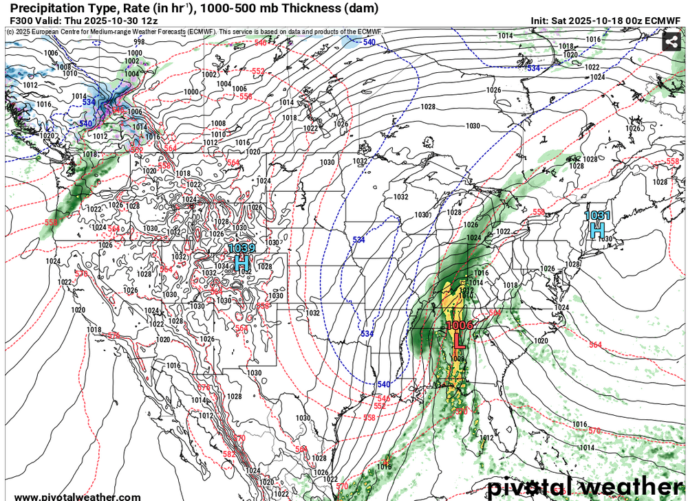
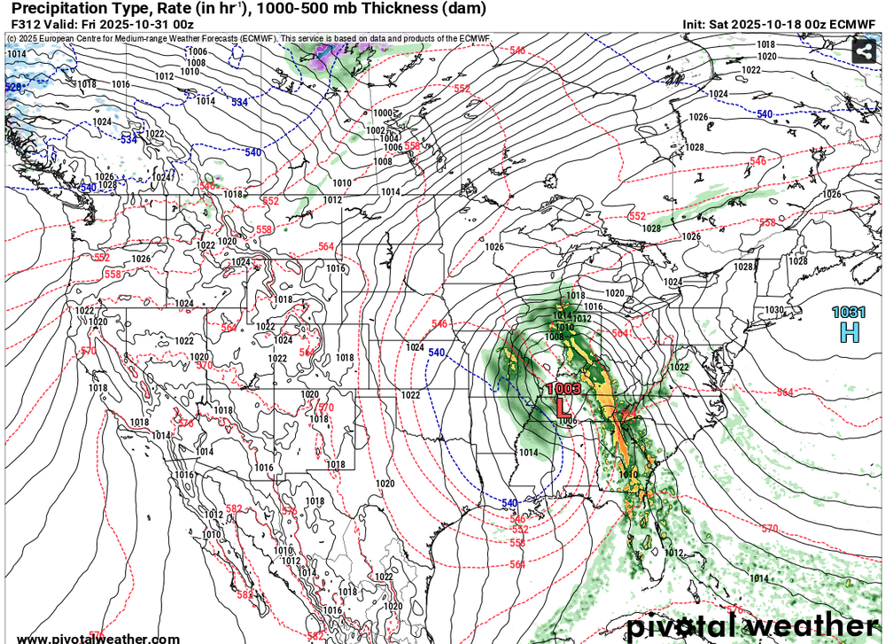
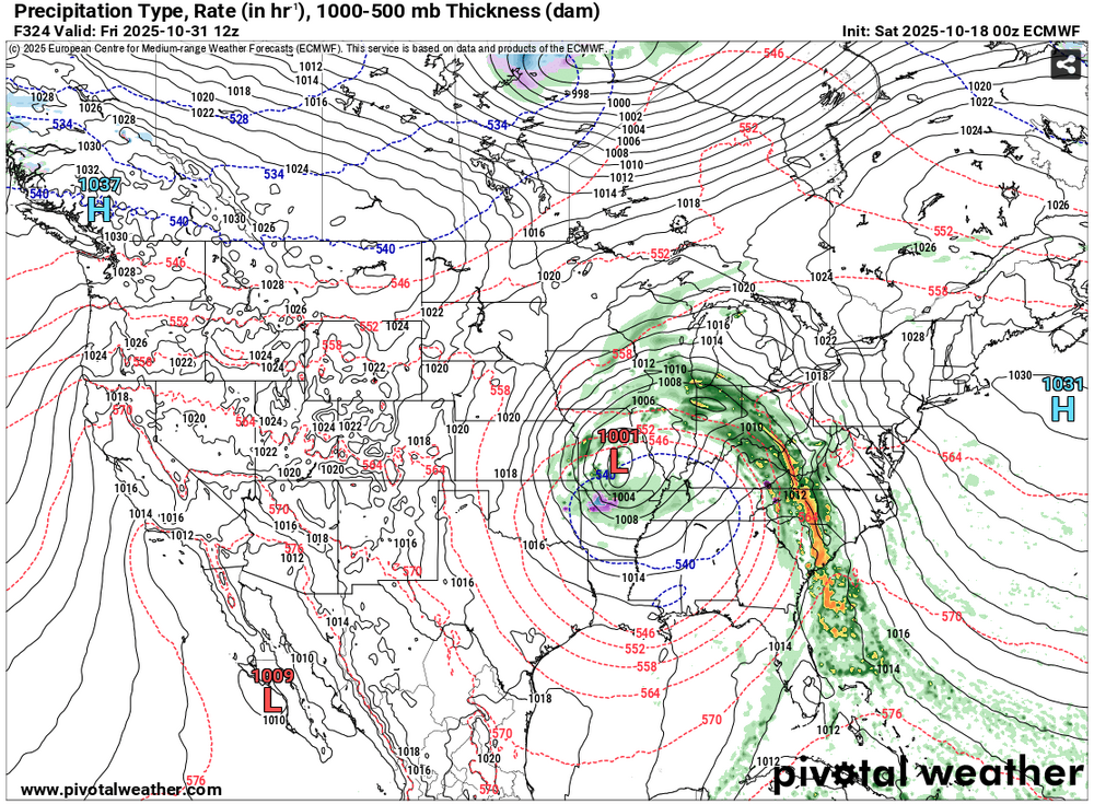
The 10/18 0z ECMWF had a really odd solution in the extended, low-skill range. I'm referring to the track/redevelopment of the low that it shows forming along a cold front over Alabama. 300 Hours: 312 Hours: 324 Hours: Afterward, the storm tracks into Iowa, across Wisconsin and into Ontario. Between hours 348 and 360 it rapidly intensifies from a central pressure of 998 mb to 972 mb. It's too soon to be sure, but odd or wild solutions, along with a lack of run-to-run continuity, often develops for periods of transition. So, this might be an early hint that the closing days of October and opening week of November might be a time to watch for a pattern change.
-
Occasional Thoughts on Climate Change
donsutherland1 replied to donsutherland1's topic in Climate Change
Science does not treat models as faith. Neither do I. Models are tools that represent physical processes, tested against data, improved through hindcasting, and used to estimate probabilities. The comment confuses trust in validated methodology with blind belief. Uncertainty in basic areas concerning whether temperatures will increase , sea level will rise, ice will melt, is low. Uncertainty about amounts exists, but it isn’t so great that it justifies inaction. -
2025-2026 ENSO
donsutherland1 replied to 40/70 Benchmark's topic in Weather Forecasting and Discussion
February 8-9, 2013 was a very big snowstorm, especially in parts of CT. From Fairfield: