donsutherland1
-
Posts
23,759 -
Joined
Content Type
Profiles
Blogs
Forums
American Weather
Media Demo
Store
Gallery
Everything posted by donsutherland1
-
From the WPC:
-
Yes, but not this time.
-
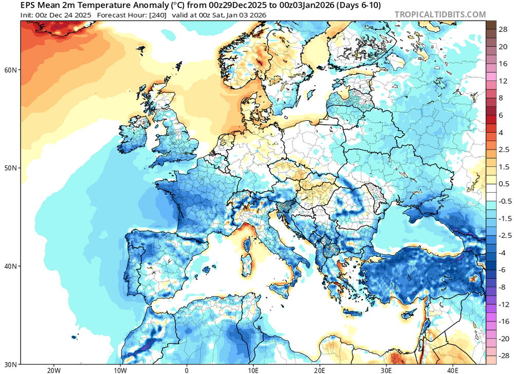
It will turn somewhat milder as a storm cuts to the Great Lakes, but the warmth won’t break through like it did in 1984.
-
The 500 mb map preceding the storm has some similarities to December 27-28, 1984. Then, NYC picked up 4.8” of snow, Boston 0.2” and Philadelphia had none.

-
Thank you. Have a wonderful Holiday season, too.
-
I didn't. There were 406 if one considers two-day periods.
-
Yes. Central Park has seen 355 days with 4" or more snowfall. That amounts to an average of about 2.3 such days each year.
-
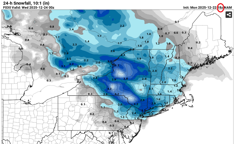
Given the strong support on the earlier individual ensembles, which span a plausible range of scenarios, I will need to see a lot more before buying into the NAM's latest solution. That a single member of the EPS had < 1" snow for NYC and none of the GEFS members had it, suggest that the idea is perhaps a very low probability scenario. It's difficult to see that 6 hours has brought about a dramatic and sharp change in the synoptic picture. Finally, the NAM was trying to dump 2.4" of snow on NYC with light precipitation, warming mid-level, and above freezing temperatures 12-18 hours before the onset of the last event. New York City received a trace. Let's see what the RGEM, GFS, UKMET, and ECMWF show over the next few hours.
-

-
It's unfortunate that this model will replace the NAM. As bad as the NAM can be, I can't argue that this model has any more skill.
-
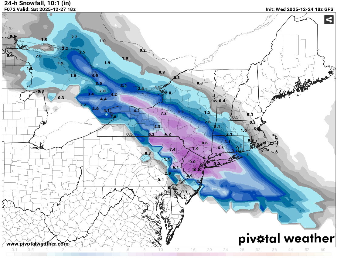
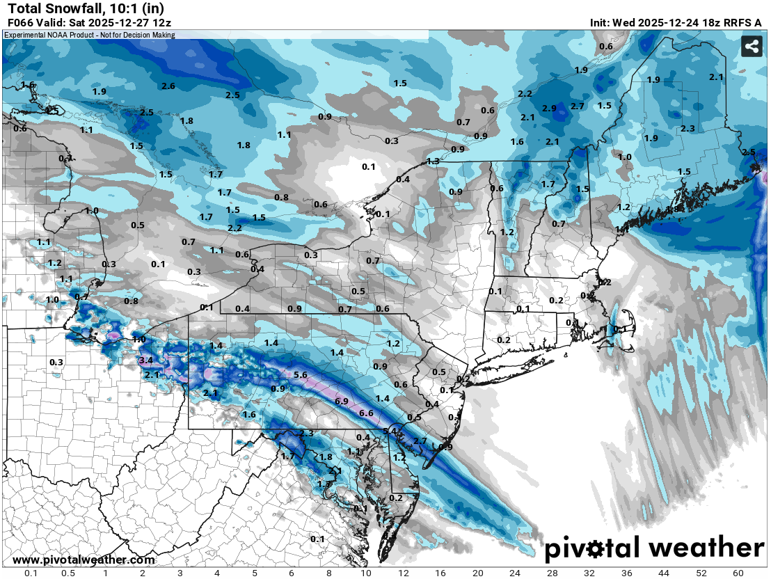
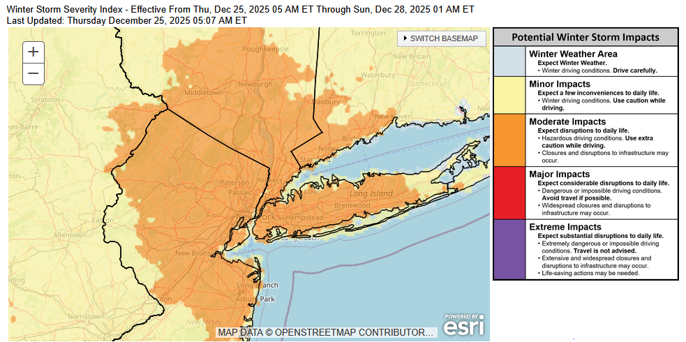
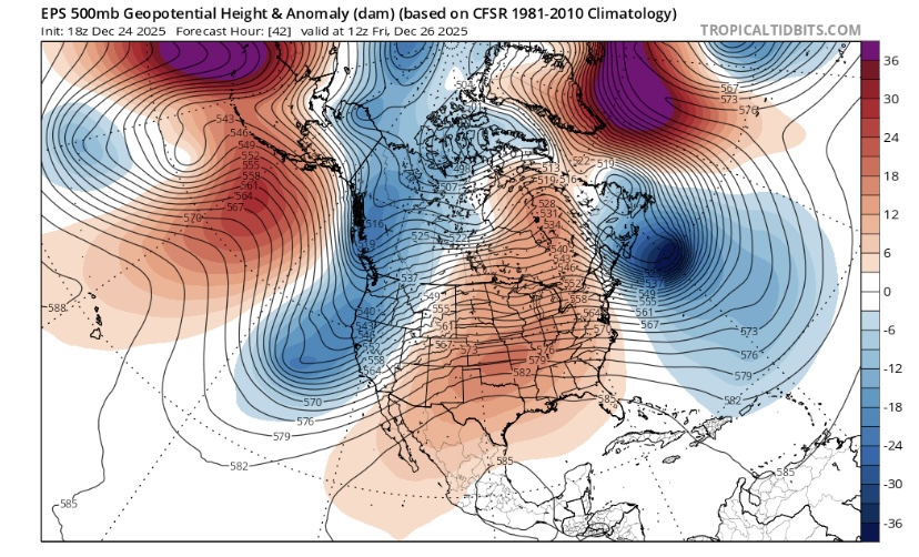
Tomorrow will be a mainly dry day with readings topping out in the lower and middle 40s. A few spots could pick up a sprinkle or shower. Colder air will then press into the region tomorrow night. That will set the stage for a winter storm to end the week. Friday will see increasing clouds. Snow will arrive during the late afternoon or evening and continue overnight. The snow could fall moderately to even heavily for a time. Sleet or freezing rain could mix in toward the end of the storm in parts of the region. A general 4"-8" snowfall is likely in and around the New York City area. The RRFS A, which will succeed the NAM, appears to have inherited the NAM's idiosyncratic behavior. It shows a narrow area of 4"-6" snows from southeastern Pennsylvania running southeastward across southern New Jersey. It shows less than 0.5" of snow in New York City and no measurable snow just north of New York City. Just one EPS member has less than 1" of snow in New York City. The RRFS A output is an outlier and is not considered. The storm will be followed by a chilly weekend. The closing days of December will likely be colder than normal. December 2025 will very likely finish with a maximum monthly temperature below 60° in New York City. The last time that happened was in 2019 when the monthly high was 58°. If 2025 has a monthly high below 60°, that would be only the fifth such occurrence since 2000 (2003, 2004, 2005, and 2019 are the cases since 2000). The ENSO Region 1+2 anomaly was -0.6°C and the Region 3.4 anomaly was -0.8°C for the week centered around December 17. For the past six weeks, the ENSO Region 1+2 anomaly has averaged -0.40°C and the ENSO Region 3.4 anomaly has averaged -0.68°C. La Niña conditions will likely continue through at least mid-winter. The SOI was +6.12 today. The preliminary Arctic Oscillation (AO) was +0.578 today. Based on sensitivity analysis applied to the latest guidance, there is an implied near 100% probability that New York City will have a cooler than normal December (1991-2020 normal). December will likely finish with a mean temperature near 33.8° (5.3° below normal). That will make December 2025 the coldest December since 2010 when the monthly mean temperature was 32.8°. It would also make 2025 the third coldest December since 2000. Supplemental Information: The projected mean would be 3.6° below the 1981-2010 normal monthly value.
-
Here's that model's 18z run:

-
Fun read from 15 years ago: 897 FXUS61 KOKX 240533 AFDOKX AREA FORECAST DISCUSSION NATIONAL WEATHER SERVICE NEW YORK NY 1233 AM EST FRI DEC 24 2010 .LONG TERM /SUNDAY THROUGH THURSDAY/... MAIN FEATURE TO KEEP AN EYE ON IS EVOLUTION OF COASTAL STORM AND HOW IT IMPACTS LOCAL CWA SUNDAY INTO MONDAY. MUCH DEPENDS ON PHASING OF SOUTHERN STREAM SHORTWAVE AND NORTHERN STREAM TROUGH DIGGING ACROSS THE GREAT LAKES REGION AS IT HEADS TOWARD THE NORTHEAST. THESE UPPER FEATURES NOW ENTERING DENSE OBSERVATION NETWORK...SO EACH SUBSEQUENT MODEL RUN SHOULD RESULT IN BETTER CLUSTERING OF SOLUTIONS. HOWEVER...A SLIGHT SHIFT TO THE EAST HAS BEEN OBSERVED WITH THIS 12Z RUN...ALONG WITH FASTER MOVEMENT OF SFC LOW SUNDAY INTO MONDAY PER EC/GFS/NAM. INITIALLY THE NAM/WRF REMAINS MUCH SLOWER WITH SOUTHERN STREAM SHORTWAVE AS IT MOVES ACROSS THE GULF THIS WEEKEND. LOW PRESSURE DEVELOPS AND DEEPENS OFF THE SOUTHEAST COAST SUNDAY MORNING AS THE MAIN TROUGH DIGS. LATEST NAM/WRF AND GFS TRACK THIS LOW JUST SOUTHEAST OF THE BENCHMARK...WITH MINIMAL QPF ACROSS THE CWA. LATEST ECMWF HAS SHIFTED EAST...PASSING JUST EAST OF THE BENCHMARK AS WELL. AS MENTIONED...SFC LOW MUCH FASTER TRACKING TO THE NORTHEAST. ECMWF CLIPS CWA...WITH BETTER CHANCE FOR PRECIP TO THE EAST. OVERALL...PLENTY OF ENSEMBLE MEMBERS STILL FORECASTING A FULL FLEDGED SNOWSTORM. WILL CONTINUE TO LAYER POPS FROM HIGHEST SE...TO LOWEST NW ZONES SUNDAY AFTERNOON AND SUNDAY NIGHT. AS FOR TIMING...SUNDAY AND SUNDAY NIGHT WOULD BE WHEN ANY ACCUMULATING SNOWFALL WOULD OCCUR...IF IT DOES. STORM MOVES WELL TO THE NORTH AND EAST ON MONDAY. LINGERING MID AND UPPER LEVEL TROUGH ALONG WITH AMPLE MOISTURE WRAPPING AROUND THE LOW COULD RESULT IN SCATTERED SNOW SHOWERS OR FLURRIES MONDAY. TEMPS COLDER THAN NORMAL SUNDAY AND MONDAY. GUSTY WINDS SUNDAY NIGHT AND MONDAY WILL MAKE IT FEEL COLDER. 906 FXUS61 KOKX 241141 AFDOKX AREA FORECAST DISCUSSION NATIONAL WEATHER SERVICE NEW YORK NY 641 AM EST FRI DEC 24 2010 .LONG TERM /SATURDAY NIGHT THROUGH THURSDAY/... GFS/ECMWF NOT TOO DISSIMILAR...AND GIVEN RANGE OF SOLUTIONS SEEN WITH THE COASTAL STORM OVER THE PAST FEW DAYS...A BLEND OF THE TWO SEEMS THE BEST WAY TO GO FOR NOW. A CLOSED LOW AT 500 HPA DEVELOPS OVER THE UPPER OHIO RIVER VALLEY SATURDAY NIGHT...TRACKS TO THE MID ATLANTIC STATES SUNDAY...THEN TO NEAR CAPE COD BY MONDAY MORNING. THIS SUPPORTS MOVING AN ALREADY DEVELOPING COASTAL LOW FROM OFF THE COAST OF THE CAROLINAS SUNDAY MORNING...TO NEAR CAPE COD BY MONDAY MORNING...AS THE LOW WORKS ON CUTTING OFF AS IT RAPIDLY DEEPENS DURING THAT TIME FRAME. THIS CUTOFF LOW THEN SLOWLY TRACKS NE INTO THE CANADIAN MARITIMES INTO TUESDAY...WITH A DEEP LAYERED RIDGE BUILDING IN BEHIND IT INTO TUESDAY NIGHT. IN TERMS OF SENSIBLE WEATHER...IT SHOULD BE DRY INTO SUNDAY MORNING...EXPECT FOR POSSIBLY A SNOW SHOWER OVER THE FAR NW LATE SAT NIGHT AS THE NE EXTENSION OF THE DEVELOPING CLOSED LOW SETS UP OVER EASTERN UPSTATE NY. COULD SEE SOME LIGHT SNOW TOWARDS MIDDAY ON SUNDAY...BUT MORE LIKELY WILL MOVE IN FROM S TO N SUNDAY AFTERNOON...WITH THE BEST CHANCE FROM THE LONG ISLAND SOUND ON S AND NYC ON EAST. TRICKY PART OF THE FORECAST FOR SUNDAY NIGHT IS EXACTLY HOW FAR WEST IS THE BACK EDGE OF THE SNOW...FOR NOW HAVE AT LEAST CHANCE POPS OVER THE ENTIRE CWA (LIKELY FAR EAST)...BUT EVEN THE GFS BARELY HAS MEASURABLE QPF INTO ORANGE COUNTY. SNOW SHOULD TAPER OFF TO SHSN/FLURRIES DURING THE DAY ON MONDAY. BASED ON THE MODEL BLEND USED...IT APPEARS THAT THERE IS A HIGH END CHANCE TO A LIKELIHOOD THAT THERE WILL BE MEASURABLE SNOW FALL EAST OF THE HUDSON RIVER...WITH THE BEST CHANCE OVER CENTRAL/EASTERN CT AND LONG ISLAND...WITH THE BEST CHANCE OF WARNING LEVEL SNOWS OVER EASTERN CT/LONG ISLAND - NOT SAYING WARNING LEVEL SNOWS ARE NOT POSSIBLE FURTHER WEST...JUST THAT THE BEST CHANCE FOR THEM IS OVER EASTERN PORTIONS OF THE CWA. IN ORDER TO GET WARNING LEVEL SNOWS WEST OF THE HUDSON...IT WOULD TAKE A SHIFT IN TRACK ABOUT 100 MILES TO THE WEST...THIS IN UNLIKELY BUT STILL WITHIN THE REALM OF POSSIBILITIES. IT ALSO POSSIBLE (AND MORE LIKELY THAN A 100 MILE WESTWARD SHIFT IN TRACK) THAT THE STORM COULD TRACK FURTHER EAST THAN FORECAST...BRINGING AT MOST ADVISORY SNOWS TO EASTERN AREAS...IF ANY PRECIPITATION AT ALL. IN ADDITION TO THE SNOW...THERE WILL BE STRONG GUSTY WINDS WITH THIS STORM. GFS BOUNDARY WINDS ARE 35 KT OR GREATER OVER CT/LONG ISLAND (WITH 50-60 KT VALUES OVER THE TWIN FORKS/SE CT) LATE SUNDAY NIGHT/MONDAY MORNING...WHILE ECMWF 925 HPA WINDS AROUND 45 KT IN THE SAME TIME FRAME. BASED ON THIS...WOULD THINK THAT AT LEAST GUSTS TO WIND ADVISORY CRITERIA ARE POSSIBLE OVER EASTERN CT/LONG ISLAND...AND MAYBE A TAD FURTHER WEST AS WELL. IT SHOULD BE NOTED THAT IF THE MORE WESTWARD TRACK OF THE GFS BARES OUT (ASSUMING THAT THE STRENGTH FORECAST OF BOTH THE GFS/ECMWF IS CORRECT - THEY ARE WITHIN 1 HPA OF EACH OTHER MOST OF THE TIME)...THEN HIGH WIND WARNING CRITERIA COULD BE MET OVER THE TWIN FORKS/SE CT...AND MAYBE A TAD FURTHER W. TOO EARLY...PLUS NOT QUITE ENOUGH CONFIDENCE FOR A WATCH...SO WILL CONTINUE TO HIGHLIGHT THREAT IN THE HWO FROM THIS STORM... STRESSING INCREASED LIKELIHOOD FOR A SIGNIFICANT WINTER STORM OVER EASTERN PORTIONS OF THE TRI-STATE. 935 FXUS61 KOKX 250033 AFDOKX AREA FORECAST DISCUSSION NATIONAL WEATHER SERVICE NEW YORK NY 733 PM EST FRI DEC 24 2010 .LONG TERM /SUNDAY THROUGH FRIDAY/... PLENTY OF UNCERTAINTY ON DETAILS WITH THE STORM PROGGED TO DEVELOP OFF THE SOUTHEAST COAST SATURDAY NIGHT AND INTENSIFY AS IT MOVES EAST OF THE MID ATLANTIC AND NEW ENGLAND COASTS SUNDAY INTO SUNDAY NIGHT...WITH MODELS STILL STRUGGLING WITH PHASING DETAILS OF MULTIPLE SHORTWAVES AS THEY COMBINE TO CARVE OUT A DEEP CLOSED LOW BY SUNDAY...WITH A FULL SPECTRUM OF OUTCOMES RANGING FROM LITTLE OR NO PRECIP TO A MAJOR WINTER STORM. THE 12Z GFS...WHILE LOOKING MOST OMINOUS...WAS NOT FULLY ACCEPTED MAINLY DUE TO INITIALIZATION PROBLEMS WITH UPSTREAM MID LEVEL DISTURBANCES EXTENDING FROM CENTRAL CANADA INTO THE NORTHERN PLAINS...WHOSE INTERACTION WILL IN TURN GREATLY INFLUENCE THE EVOLUTION OF THE COASTAL STORM. THE 12Z ECMWF INITIALIZED THESE FEATURES A LITTLE BETTER BUT STILL NOT PERFECTLY...AND ITS SFC LOW TRACK SUNDAY NIGHT INTO MONDAY...WHILE RIDING A STRONG LOW LEVEL BAROCLINIC ZONE...STILL LOOKS A LITTLE TOO FAR EAST GIVEN THE STRONGER MID LEVEL FORCING LOCATED TO THE WEST. AS A RESULT...THE MOST LIKELY OUTCOME AND COURSE OF LEAST REGRET IS EITHER STRAIGHT CONTINUITY FROM THE PREVIOUS FORECAST...OR A BLEND OF THE 06Z GFS AND 00Z ECMWF...WITH A LOW TRACK CLOSE ENOUGH TO DELIVER ADVISORY CRITERIA SNOWS TO SOUTHEAST CT AND EASTERN LONG ISLAND...LESSER AMOUNTS WESTWARD TO SW CT AND NYC METRO...AND LITTLE IF ANY ACCUMULATION WELL NORTH AND WEST OF NYC. IT SHOULD BE NOTED THAT THE PROBABILITY OF A SIGNIFICANT SNOWSTORM WITH AMOUNTS OVER 6 INCHES IS STILL NONZERO BUT IS LOW...ONLY 30-40 PERCENT FOR EASTERNMOST CT/LONG ISLAND...AND 10-20 PERCENT FARTHER WEST. FORECAST DETAILS MAY STILL BE SUBJECT TO SIGNIFICANT CHANGES IN EITHER DIRECTION AS CONFIDENCE IN THE INTERACTION OF THE MULTIPLE SHORTWAVES TO FORM THIS SYSTEM INCREASES...SO STAY TUNED. 397 FXUS61 KOKX 250528 AFDOKX AREA FORECAST DISCUSSION NATIONAL WEATHER SERVICE NEW YORK NY 1228 AM EST SAT DEC 25 2010 .LONG TERM /SUNDAY NIGHT THROUGH FRIDAY/... PLENTY OF UNCERTAINTY ON DETAILS WITH THE STORM PROGGED TO DEVELOP OFF THE SOUTHEAST COAST SATURDAY NIGHT AND INTENSIFY AS IT MOVES EAST OF THE MID ATLANTIC AND NEW ENGLAND COASTS SUNDAY INTO SUNDAY NIGHT...WITH MODELS STILL STRUGGLING WITH PHASING DETAILS OF MULTIPLE SHORTWAVES AS THEY COMBINE TO CARVE OUT A DEEP CLOSED LOW BY SUNDAY...WITH A FULL SPECTRUM OF OUTCOMES RANGING FROM LITTLE OR NO PRECIP TO A MAJOR WINTER STORM. THE 12Z GFS...WHILE LOOKING MOST OMINOUS...WAS NOT FULLY ACCEPTED MAINLY DUE TO INITIALIZATION PROBLEMS WITH UPSTREAM MID LEVEL DISTURBANCES EXTENDING FROM CENTRAL CANADA INTO THE NORTHERN PLAINS...WHOSE INTERACTION WILL IN TURN GREATLY INFLUENCE THE EVOLUTION OF THE COASTAL STORM. THE 12Z ECMWF INITIALIZED THESE FEATURES A LITTLE BETTER BUT STILL NOT PERFECTLY...AND ITS SFC LOW TRACK SUNDAY NIGHT INTO MONDAY...WHILE RIDING A STRONG LOW LEVEL BAROCLINIC ZONE...STILL LOOKS A LITTLE TOO FAR EAST GIVEN THE STRONGER MID LEVEL FORCING LOCATED TO THE WEST. AS A RESULT...THE MOST LIKELY OUTCOME AND COURSE OF LEAST REGRET IS EITHER STRAIGHT CONTINUITY FROM THE PREVIOUS FORECAST...OR A BLEND OF THE 06Z GFS AND 00Z ECMWF...WITH A LOW TRACK CLOSE ENOUGH TO DELIVER ADVISORY CRITERIA SNOWS TO SOUTHEAST CT AND EASTERN LONG ISLAND...LESSER AMOUNTS WESTWARD TO SW CT AND NYC METRO...AND LITTLE IF ANY ACCUMULATION WELL NORTH AND WEST OF NYC. IT SHOULD BE NOTED THAT THE PROBABILITY OF A SIGNIFICANT SNOWSTORM WITH AMOUNTS OVER 6 INCHES IS STILL NONZERO BUT IS LOW...ONLY 30-40 PERCENT FOR EASTERNMOST CT/LONG ISLAND...AND 10-20 PERCENT FARTHER WEST. FORECAST DETAILS MAY STILL BE SUBJECT TO SIGNIFICANT CHANGES IN EITHER DIRECTION AS CONFIDENCE IN THE INTERACTION OF THE MULTIPLE SHORTWAVES TO FORM THIS SYSTEM INCREASES...SO STAY TUNED. 536 FXUS61 KOKX 251143 AFDOKX AREA FORECAST DISCUSSION NATIONAL WEATHER SERVICE NEW YORK NY 643 AM EST SAT DEC 25 2010 BY SUNDAY MORNING AND AFTERNOON...THE SURFACE LOW WILL CONTINUE TO DEEPEN AND MOVE IN A NORTHEAST DIRECTION AS UPPER LEVEL TROUGH CLOSES OFF. DECREASING WAVELENGTH BETWEEN TROUGH AND RIDGE DOWNSTREAM WILL FAVOR CONTINUING OFFSHORE CYCLOGENESIS. SNOW COULD START AS EARLY AS SUNDAY MORNING BUT MOST OF WILL FALL SUNDAY AFTERNOON THROUGH SUNDAY NIGHT TIMEFRAME COINCIDING WITH THE APPROACH OF THE OMEGA FIELD AND RAPID DEEPENING OF THE LOW PRESSURE. GENERALLY GFS AND ECMWF ARE SIMILAR WITH THE ECMWF SHOWING A LARGE CHANGE BETWEEN 12Z AND 00Z RUNS FROM MORE OFFSHORE TO CLOSER TO COAST. THE NAM...GEM...AND UKMET ARE FARTHER OFFSHORE WITH THE SURFACE LOW WITH THE SREF IN BETWEEN AND CLOSE TO THE 40N/70W BENCHMARK. THE SREF HAS TRENDED HIGHER WITH PROBABILITY OF MEASURABLE PRECIP AS WELL. THE TRACK STILL HAS UNCERTAINTY AS GFS O6Z RUN TRENDED A LITTLE FARTHER TO THE WEST. THIS COULD HAVE RESULTING CHANGES TO QPF AMOUNTS AND RAIN/SNOW LINE WITH THE FORECAST IF THIS TREND HOLDS WITH OTHER MODEL GUIDANCE. THEREFORE...POPS INCREASED LIKELY TO CATEGORICAL FOR SUNDAY AFTERNOON AND NIGHT AND WITH A BLEND OF HPC/SREF/NAM QPF AS WELL AS ACCOUNTING FOR AROUND 10 TO 1 SNOW TO LIQUID RATIOS...SNOW COULD ACCUMULATE GENERALLY 6 TO 9 INCHES WITH LOCALLY HIGHER AMOUNTS ESPECIALLY FARTHER EAST OR IF MESOSCALE ENHANCED BANDING SETS UP. QPF AND SNOWFALL AMOUNTS ARE IN A NW TO SE GRADIENT WITH HIGHER TOTALS TOWARDS THE SOUTHERN AND EASTERN PORTIONS. THINK THAT PLACES FARTHER SOUTH AND EAST WILL HAVE MORE OF A HEAVY WET SNOW. WINTER STORM WATCH WAS ISSUED WITH HIGHER CONFIDENCE AS MODEL AGREEMENT HAS INCREASED COMPARED TO PREVIOUS MODEL RUNS ESPECIALLY WITH ECMWF TRENDING CLOSER TO THE COAST. STEEP GRADIENT IN PRESSURE AS LOW PRESSURE DROPS DUE TO BAROCLINICITY WILL ALSO RESULT IN VERY GUSTY WINDS 35 TO 40 MPH...WITH HIGHER CHANCE OF THESE WINDS TOWARDS THE COAST FOR SUNDAY AFTERNOON THROUGH MONDAY AFTERNOON. NEAR BLIZZARD CONDITIONS ARE POSSIBLE ESPECIALLY FOR EASTERN SECTIONS. 816 FXUS61 KOKX 251834 CCA AFDOKX AREA FORECAST DISCUSSION...CORRECTED NATIONAL WEATHER SERVICE NEW YORK NY 128 PM EST SAT DEC 25 2010 BY SUNDAY MORNING AND AFTERNOON...THE SURFACE LOW WILL CONTINUE TO DEEPEN AND MOVE IN A NORTHEAST DIRECTION AS UPPER LEVEL TROUGH CLOSES OFF. DECREASING WAVELENGTH BETWEEN TROUGH AND RIDGE DOWNSTREAM WILL FAVOR CONTINUING OFFSHORE CYCLOGENESIS. SNOW COULD START AS EARLY AS SUNDAY MORNING BUT MOST OF WILL FALL SUNDAY AFTERNOON THROUGH SUNDAY NIGHT TIME FRAME COINCIDING WITH THE APPROACH OF THE OMEGA FIELD AND RAPID DEEPENING OF THE LOW PRESSURE. GENERALLY GFS AND ECMWF ARE SIMILAR WITH THE ECMWF SHOWING A LARGE CHANGE BETWEEN 12Z AND 00Z RUNS FROM MORE OFFSHORE TO CLOSER TO COAST. THE NAM...GEM...AND UKMET ARE FARTHER OFFSHORE WITH THE SURFACE LOW WITH THE SREF IN BETWEEN AND CLOSE TO THE 40N/70W BENCHMARK. THE SREF HAS TRENDED HIGHER WITH PROBABILITY OF MEASURABLE PRECIP AS WELL. THE TRACK STILL HAS UNCERTAINTY AS GFS O6Z RUN TRENDED A LITTLE FARTHER TO THE WEST. THIS COULD HAVE RESULTING CHANGES TO QPF AMOUNTS AND RAIN/SNOW LINE WITH THE FORECAST IF THIS TREND HOLDS WITH OTHER MODEL GUIDANCE. THEREFORE...POPS INCREASED LIKELY TO CATEGORICAL FOR SUNDAY AFTERNOON AND NIGHT AND WITH A BLEND OF HPC/SREF/NAM QPF AS WELL AS ACCOUNTING FOR AROUND 10 TO 1 SNOW TO LIQUID RATIOS...SNOW COULD ACCUMULATE GENERALLY 6 TO 12 INCHES WITH LOCALLY HIGHER AMOUNTS ESPECIALLY FARTHER EAST OR IF MESOSCALE ENHANCED BANDING SETS UP. QPF AND SNOWFALL AMOUNTS ARE IN A NW TO SE GRADIENT WITH HIGHER TOTALS TOWARDS THE SOUTHERN AND EASTERN PORTIONS. THINK THAT PLACES FARTHER SOUTH AND EAST WILL HAVE MORE OF A HEAVY WET SNOW. WINTER STORM WATCH WAS ISSUED WITH HIGHER CONFIDENCE AS MODEL AGREEMENT HAS INCREASED COMPARED TO PREVIOUS MODEL RUNS ESPECIALLY WITH ECMWF TRENDING CLOSER TO THE COAST. STEEP GRADIENT IN PRESSURE AS LOW PRESSURE DROPS DUE TO BAROCLINICITY WILL ALSO RESULT IN VERY GUSTY WINDS 35 TO 40 MPH...WITH HIGHER CHANCE OF THESE WINDS TOWARDS THE COAST FOR SUNDAY AFTERNOON THROUGH MONDAY AFTERNOON. NEAR BLIZZARD CONDITIONS ARE POSSIBLE ESPECIALLY FOR EASTERN/COASTAL SECTIONS. 410 FXUS61 KOKX 252021 AFDOKX AREA FORECAST DISCUSSION NATIONAL WEATHER SERVICE NEW YORK NY 321 PM EST SAT DEC 25 2010 ...POWERFUL WINTER STORM TO BRING BLIZZARD CONDITIONS TO NYC METRO...LONG ISLAND AND MUCH OF SOUTHERN CONNECTICUT... .SHORT TERM /6 AM SUNDAY MORNING THROUGH TUESDAY/... WE WILL BE ISSUING BLIZZARD WARNINGS FOR MUCH OF THE CWA...AND WINTER STORM WARNINGS FOR THE LOWER HUDSON VALLEY...FOR THE INTENSE STORM PROGGED TO IMPACT THE AREA FROM SUNDAY INTO MONDAY AFTERNOON. EXPECTATION IS FOR HEAVY SNOW TO DEVELOP EARLIER THAN EXPECTED...BY MID TO LATE AFTERNOON SUNDAY...AND CONTINUE INTO MUCH OF SUNDAY NIGHT. TOTAL ACCUMULATIONS SHOULD RANGE FROM 8-12 INCHES NW OF NYC AND 12-16 INCHES MOST ELSEWHERE...WITH HIGHER LOCAL AMOUNTS WHERE BEST MESOSCALE BANDING SETS UP. STILL COULD BE SOME MIXING ISSUES ACROSS EASTERN LONG ISLAND AND SOUTHEAST CT. NORTHERLY WINDS WILL GUST WELL OVER 35 MPH OVER MOST OF THE BLIZZARD WARNING AREA...APPROACHING 50-55 MPH OVER CENTRAL AND EASTERN LONG ISLAND AT THE HEIGHT OF THE STORM...WITH CONSIDERABLE BLOWING/DRIFTING SNOW AND VERY POOR VSBY. MORE DETAILS TO FOLLOW BY ABOUT 4 PM. 965 FXUS61 KOKX 252153 AFDOKX AREA FORECAST DISCUSSION NATIONAL WEATHER SERVICE NEW YORK NY 453 PM EST SAT DEC 25 2010 .SHORT TERM /6 AM SUNDAY MORNING THROUGH TUESDAY/... WE HAVE ISSUED BLIZZARD WARNINGS FOR MUCH OF THE CWA...AND WINTER STORM WARNINGS FOR THE LOWER HUDSON VALLEY AND INTERIOR SW CT...FOR THE INTENSE STORM PROGGED TO IMPACT THE AREA FROM SUNDAY INTO MONDAY AFTERNOON. FCST MODELS ARE IN GOOD AGREEMENT ON THE WEAK LOW NOW S OF THE FLORIDA PANHANDLE LATE THIS AFTERNOON INTENSIFYING INTO A MAJOR COASTAL STORM WITH CENTRAL PRESSURE NEAR 970 MB AS IT MOVES OFF THE CAROLINA COAST SUNDAY MORNING... THEN TURNS NE TO A POSITION INSIDE THE 40/70 BENCHMARK. EXPECTATION IS FOR SNOW TO DEVELOP EARLIER THAN EXPECTED...BY MID TO LATE MORNING SUNDAY...BECOME MODERATE TO HEAVY BY LATE SUNDAY AFTERNOON...AND CONTINUE INTO MUCH OF SUNDAY NIGHT. WITH THE H5 CLOSED LOW HUGGING THE MID ATLANTIC COAST...PRECEDED BY INTENSE CPVA AND STRONG MID LEVEL FRONTOGENESIS...IT APPEARS ATTM THAT LONG ISLAND AND SOUTHERN CT SHOULD SEE THE HIGHEST SNOWFALL TOTALS OF 12-16 INCHES...WITH 8-12 INCHES FARTHER NORTH/WEST. HIGHER LOCAL AMOUNTS ARE POSSIBLE WHERE HEAVIEST SNOW BANDS SET UP...STILL AN UNKNOWN AS FCST MODELS HAVE A HARD TIME PINPOINTING THESE MESOSCALE FEATURES THIS FAR OUT IN TIME...AND TEND TO BE TOO FAR SOUTH/EAST...SO AREAS NORTH/WEST OF NYC COULD POSSIBLY SEE HIGHER AMOUNTS THAN CURRENTLY FCST. RAPID PRESSURE FALLS SHOULD INDUCE A STRONG ISALLOBARIC N FLOW...WHICH SHOULD KEEP MOST AREAS ALL SNOW...THOUGH THE FORKS OF LONG ISLAND AND POSSIBLY FAR SE CT COULD BRIEFLY MIX WITH OR CHANGE TO RAIN/SLEET AS THE SFC LOW MAKES ITS CLOSEST APPROACH...TOO LITTLE TOO LATE TO KEEP THOSE AREAS FROM RECEIVING SIGNIFICANT SNOWFALL. THE STRONG NORTHERLY FLOW WILL GUST TO 40-55 MPH AT TIMES...ESPECIALLY INVOF NYC AND COASTAL SECTIONS. THIS IN COMBINATION WITH HEAVY SNOW WILL CREATE BLIZZARD CONDITIONS CLOSER TO THE COAST...WITH WITH CONSIDERABLE BLOWING/DRIFTING SNOW AND VERY POOR VSBY. NOT QUITE AS CONFIDENT ON GUST FREQUENCY OVER 35 MPH OR DURATION OF HEAVY SNOW FARTHER INLAND...WHICH IS WHY BLIZZARD WARNINGS DO NOT COVER THE ENTIRE CWA ATTM. MESOSCALE TRENDS AS THE STORM GETS UNDER WAY MAY DICTATE OTHERWISE...SO STAY TUNED. 876 FXUS61 KOKX 261915 AFDOKX AREA FORECAST DISCUSSION NATIONAL WEATHER SERVICE NEW YORK NY 215 PM EST SUN DEC 26 2010 .NEAR TERM /THROUGH TONIGHT/... SOME IMPORTANT CHANGES FORTHCOMING WITH THIS UPDATE. BASED ON EARLIER THINKING...AND WITH 12Z GFS/NAM BOTH IN CLOSE PROXIMITY ON LOW TRACK AND QPF...HAVE BUMPED UP SNOW TOTALS AND ALSO EXPANDED BLIZZARD WARNINGS TO THE ENTIRE CWA. INTENSE MESOSCALE BANDING EXPECTED TO PIVOT INTO NYC METRO AND WESTERN/CENTRAL LONG ISLAND LATER TODAY/TONIGHT SHOULD DELIVER STORM TOTAL SNOWFALL OF 15-20 INCHES...LOCALLY AS MUCH AS 2 FEET. OTHER AREAS IN THE CWA SHOULD SEE 12-18 INCHES. WIND WILL BE A LIMITING FACTOR ON WHAT WOULD OTHERWISE HAVE BEEN EXCELLENT SNOW RATIOS OF 15-1 OR 20-1 GIVEN INTENSE LIFT AT IDEAL SNOW GROWTH TEMPERATURES ALOFT...WITH ROEBBER NEURAL NET ALGORITHM SUGGESTING GREATER LIKELIHOOD OF RATIOS UNDER 10-1...SO USED CLIMATOLOGICAL 11-1 RATIO INSTEAD AND SCALED DOWN WHERE TEMPS RISE ABOVE FREEZING. NAM/GFS ALSO IN CLOSER AGREEMENT ON MIXING BEING LIMITED TO THE SOUTH FORK OF EASTERN LONG ISLAND...SO WILL HAVE LOWER AMOUNTS MAINLY 6-12 INCHES THERE. FROM EARLIER DISCUSSION...EXACTLY WHERE HEAVIEST SNOW WILL FALL LATER TODAY INTO TONIGHT MAY BE COMING MORE INTO FOCUS. THE 12Z NAM SHOWED ITS STRONGEST H7-8 LAYER FRONTOGENESIS DISPLACED ABOUT 30 MILES NW OF THE STRONGEST RADAR RETURNS OFF DELMARVA ATTM...NO SURPRISE THERE AS THIS OFTEN HAPPENS WITH INTENSE COASTAL STORMS. TAKING THE NAM OTHERWISE AS A PERFECT PROG AND FOLLOWING EVOLUTION OF ITS FRONTOGENETIC FORCING INDICATES THAT THE HEAVIEST SNOW WILL OCCUR OVER SOUTH CENTRAL CT INTO WESTERN SUFFOLK AND NASSAU COUNTIES ON LONG ISLAND..POSSIBLY A LITTLE FARTHER WEST INTO SOUTHWEST CT AND NYC IF YOU LOOK AT H7 FRONTOGENESIS ONLY. PER ABOVE HAVE INCREASED MAX TOTALS...AS THAT BANDING LOOKS TO SET UP THERE TOWARD EVENING AND REMAIN FOR A GOOD CHUNK OF THE NIGHT. THE DEEP LOW WILL ALSO PRODUCE A POTENTIALLY DAMAGING WIND FIELD. BL WINDS IN THE GFS STILL CLOSE TO 60 KT OVER LONG ISLAND. NAM WIND FIELDS ARE WEAKER AT THE COAST BUT STRONGER INLAND. FOR THIS REASON HAVE BUMPED WIND GUSTS UP TO 45-60 MPH AND EXTENDED BLIZZARD WARNINGS TO ENTIRE CWA. LOCALLY HIGHER GUSTS POSSIBLE ACROSS EASTERN LI. 491 FXUS61 KOKX 262112 AFDOKX AREA FORECAST DISCUSSION NATIONAL WEATHER SERVICE NEW YORK NY 412 PM EST SUN DEC 26 2010 .NEAR TERM /THROUGH MONDAY/... 20Z MESOSCALE UPDATE...RADAR SHOWS HEAVY SNOW VIA INTENSE FRONTOGENETIC BANDING TAKING PLACE FROM NYC METRO NORTHEAST ACROSS SOUTHWEST CT...WITH ADDITIONAL HEAVY BANDS POISED TO MOVE UP INTO NYC METRO AND WESTERN LONG ISLAND AFTER DARK AND REMAIN FOR A GOOD PORTION OF TONIGHT...SO WILL HOLD WITH EARLIER IDEA OF 15-20 INCHES AND LOCAL AMOUNTS UP TO 2 FT. RUMBLES OF THUNDER ALSO POSSIBLE TONIGHT WITH HEAVIEST SNOW...WITH MODEL CROSS SECTIONS SHOWING INTENSE FRONTOGENETIC UPGLIDE TOPPED BY A NARROW LAYER OF NEGATIVE SATURATED EPV AND/OR PURE CONVECTIVE INSTABILITY. FARTHER EAST...DRY PUNCH ON SAT WV IMAGERY HAS CAUSED SNOW BANDS TO BECOME LESS INTENSE/ORGANIZED...AND AS A RESULT WILL BE CUTTING BACK ON TOTALS THERE...WITH MORE IN THE WAY OF LIGHT/MODERATE SNOW THERE UNTIL BANDING TO THE WEST PIVOTS IN LATER TONIGHT...BUT STILL TOTALS 10-15 INCHES...AND 6-8 INCHES ON THE EASTERNMOST SOUTH FORK WHERE RAIN COULD STILL MIX IN FOR A PERIOD TONIGHT. SNOW ALSO NOT QUITE AS HEAVY YET IN ORANGE COUNTY SO BACKED OFF SLIGHTLY ON TOTALS THERE...WITH 10-15 INCHES. OTHER AREAS NOT MENTIONED ABOVE STILL ON TRACK FOR 12-18 INCHES. AS NOTED EARLIER...WIND WILL BE A LIMITING FACTOR ON WHAT WOULD OTHERWISE HAVE BEEN EXCELLENT SNOW RATIOS OF 15-1 OR 20-1 GIVEN INTENSE LIFT AT IDEAL SNOW GROWTH TEMPERATURES ALOFT...WITH ROEBBER NEURAL NET ALGORITHM SUGGESTING GREATER LIKELIHOOD OF RATIOS UNDER 10-1...SO USED CLIMATOLOGICAL 11-1 RATIO INSTEAD AND SCALED DOWN WHERE TEMPS RISE ABOVE FREEZING. THE DEEP LOW WILL ALSO PRODUCE A POTENTIALLY DAMAGING WIND FIELD...WITH GUSTS 45-60 MPH EXPECTED...HIGHEST NEAR THE COAST AND IN THE HIGHER INTERIOR ELEVATIONS. THE STORM WINDS DOWN MONDAY WITH STRONG WINDS CONTINUING. THE ACCUMULATING SNOW APPEARS IT WILL BE OVER BY MID TO LATE MORNING. 377 FXUS61 KOKX 270710 AFDOKX AREA FORECAST DISCUSSION NATIONAL WEATHER SERVICE NEW YORK NY 210 AM EST MON DEC 27 2010 .NEAR TERM /THROUGH TODAY/... A 976 MB LOW ABOUT 150 NM SE OF LONG ISLAND...WILL CONTINUE TO INTENSIFY AS IT TRACKS NORTHEAST TOWARDS NANTUCKET OVERNIGHT. MESOSCALE HEAVY SNOW BANDS OF AROUND 1 INCH PER HOUR CONTINUE TO WORK NW FROM THE OCEAN...MERGING INTO A FAIRLY BROAD AND NEARLY STATIONARY SNOW BAND ACROSS SW CONN/NYC/LOWER HUDSON VALLEY/NORTHEAST NEW JERSEY AND WESTERN LI. SNOWFALL RATES OF 2 TO 4 INCHES PER HOUR CAN BE EXPECTED IN THIS BAND. THE BAND IS ONLY EXPECTED TO SLOWLY PULL NE THROUGH THE NEXT 3 TO 5 HOURS...INCREASING CONFIDENCE IN 15-20 INCHES AND LOCAL AMOUNTS UP TO 2 FT WILL FALL ACROSS THIS REGION. ISOLATED RUMBLES OF THUNDER ALSO EXPECTED TO CONTINUE WITH BANDING. COASTAL FRONT LOOKS TO HOLD BETWEEN MONTAUK POINT AND BLOCK ISLAND...WITH MAINLY SNOW NOW EXPECTED ACROSS FAR EASTERN PORTIONS OF THE REGION THROUGH THE REMAINDER OF THE EVENT...JUST SOME SLEET MIXING IN ACROSS TWIN FORKS. 10 TO 16 INCHES OUTSIDE OF THIS STATIONARY BAND ACROSS EASTERN LI AND CT. THE DEEP LOW WILL ALSO CONTINUE TO PRODUCE POTENTIALLY DAMAGING WINDS THROUGH THE OVERNIGHT...WITH GUSTS OF 50 TO 60 MPH EXPECTED THROUGH AROUND 06-08Z...HIGHEST NEAR THE COAST AND IN THE HIGHER INTERIOR ELEVATIONS. WINDS EXPECTED TO GRADUALLY SUBSIDE LATE TONIGHT. ZERO VISIBILITY EXPECTED IN HEAVIEST BANDS AND STRONG WINDS...WITH TRAVEL NOT RECOMMENDED UNLESS ABSOLUTELY NECESSARY OVERNIGHT. HEAVIEST SNOW BAND IS EXPECTED TO PULL NE BETWEEN 04Z TO 08Z FROM SW TO NE AS INTENSE LOW PRESSURE TRACK SE OF NANTUCKET. THE STORM WINDS DOWN MONDAY WITH STRONG WINDS CONTINUING. THE ACCUMULATING SNOW APPEARS IT WILL BE OVER BY MID TO LATE MORNING. 034 FXUS61 KOKX 271211 AFDOKX AREA FORECAST DISCUSSION NATIONAL WEATHER SERVICE NEW YORK NY 711 AM EST MON DEC 27 2010 .NEAR TERM /UNTIL 6 PM THIS EVENING/... A 976 MB LOW...ABOUT 50 NM ESE OF LONG ISLAND...WILL CONTINUE TO INTENSIFY AS IT TRACKS NORTHEAST INTO THE GULF OF MAINE TODAY. IN ITS WAKE...MULTIPLE DEFORMATION BANDS GOING STRONG ACROSS THE REGION EARLY THIS MORNING AS MID-LEVEL DEFORMATION AXIS INTERACTS WITH WRAP AROUND MOISTURE...WITH SNOWFALL RATES UP TO 1 TO 2 INCHES PER HOUR AND ACCOMPANYING VISIBILITIES OF 1/4 MILE OR LESS IN THESE BANDS. EXPECT THIS BANDING ACTIVITY TO GRADUALLY SHIFT EASTWARD THROUGH THE EARLY TO MID MORNING HOURS AS MID LEVEL DEFORMATION AXIS SLIDES EAST AND LOW-LEVEL WAA FROM THE NORTH CEASES. SOME OROGRAPHIC ENHANCEMENT OF BANDING WILL LIKELY BE REALIZED ACROSS CENTRAL AND EASTERN LI. WITH MOST PERSISTENT BANDING ACROSS WESTERN PORTION OF THE CWA OVER THE LAST 18 HRS...FINAL SNOWFALL TOTALS OF 18 TO 24 INCHES...AND LOCALLY UP TO 30 INCHES...ARE WELL ON THE WAY TO BEING REALIZED IN A N/S CORRIDOR ACROSS NORTHEAST NEW JERSEY AND LOWER HUDSON VALLEY. 15-20 INCHES ACROSS NYC METRO...SW CT...AND WESTERN LI. WIDER RANGE OF 8 TO 16 INCHES ACROSS EASTERN LI AND SE CONN...DUE TO REGION BEING IMPACTED BY MORE INTERMITTENT FEEDER BANDING. SEE NYCPNSOKX FOR LATEST SNOWFALL TOTALS FROM THE STORM. A TIGHT GRADIENT IN WAKE OF INTENSE LOW PRESSURE WILL CONTINUE TO PRODUCE POTENTIALLY DAMAGING WINDS TODAY. 50-55 KT WINDS AT TOP OF MIXED LAYER THROUGH MUCH OF THE DAY...WILL CONTINUE TO BRING POTENTIAL FOR GUSTS UP TO 50 MPH INTO THE AFTERNOON. HIGHEST ACROSS CITY/COAST AND HIGHER ELEVATIONS. CONSIDERABLE BLOWING AND DRIFTING OF SNOW EXPECTED TODAY. SEE NYCPNSOKX FOR PEAK WIND GUSTS FROM THE STORM. MESOSCALE BANDING IS EXPECTED TO DETERIORATE INTO SCATTERED SNOW SHOWER ACTIVITY FROM W TO E LATER THIS MORNING INTO EARLY AFTERNOON FROM W TO E. BLIZZARD WARNINGS HAVE BEEN CUT BACK TO MIDDAY TO COINCIDE WITH EXPECTED END OF ACCUMULATING SNOW AND POTENTIAL FOR 1/4 MILE OR LESS VISIBILITIES. WITH NEWLY FALLEN SNOW AND AFTERNOON CAA...TEMPS EXPECTED TO HOLD IN THE MID TO UPPER 20S AREAWIDE TODAY...10-15 DEGREES BELOW SEASONABLE. WINDCHILLS AROUND 0 THIS MORNING...ONLY RISING INTO THE SINGLE DIGITS/LOWER TEENS THIS AFTERNOON. 528 FXUS61 KOKX 271744 AFDOKX AREA FORECAST DISCUSSION NATIONAL WEATHER SERVICE NEW YORK NY 1244 PM EST MON DEC 27 2010 .NEAR TERM /UNTIL 6 PM THIS EVENING/... THE INTENSE STORM IS NOW CENTERED ABOUT 90 MILES E OF CAPE COD...LOOKING VERY MUCH LIKE A TROPICAL CYCLONE WITH SPIRAL BANDING VERY EVIDENT IN VISIBLE SATELLITE IMAGERY. AS SKIES CLEAR TO THE WEST OF NYC...VIS SATELLITE NOW ALSO SHOWING WHERE HEAVIEST SNOWS FELL OVER NORTHEAST AND CENTRAL NJ...WITH HIGHEST AMOUNTS OVER 30 INCHES. DROPPED BLIZZARD WARNING EARLIER...BUT WITH COMBO OF STRONG WINDS GUSTING UP TO 45 KT...CREATING AREAS OF BLOWING SNOW AND POSSIBLY COVERING PREVIOUSLY PLOWED ROADS...OPTED TO ISSUE A SINGLE WINTER WX ADVISORY COVERING THESE HAZARDS RATHER THAN ISSUE SEPARATE PRODUCTS...MAKING FOR A SMOOTHER TRANSITION FROM THE BLIZZARD WARNING AND HOPEFULLY PROVIDING A MORE CONSISTENT MESSAGE. SEE OUR PUBLIC INFORMATION STATEMENT ON THE WORLD WIDE WEB AT WEATHER.GOV/NYC FOR LATEST SNOWFALL TOTALS AND HIGHEST WIND GUSTS. WITH NEWLY FALLEN SNOW AND AFTERNOON CAA...TEMPS EXPECTED TO HOLD IN THE 20S TODAY...10-15 DEGREES BELOW AVERAGE. AFTERNOON WIND CHILLS WILL BE IN THE SINGLE DIGITS AND LOWER TEENS. 699 NOUS41 KOKX 272036 PNSOKX CTZ005>012-NJZ002-004-006-103>108-NYZ067>075-078>081-176>179-280801- PUBLIC INFORMATION STATEMENT SPOTTER REPORTS NATIONAL WEATHER SERVICE NEW YORK NY 336 PM EST MON DEC 27 2010 THE FOLLOWING ARE UNOFFICIAL OBSERVATIONS TAKEN DURING THE PAST 29 HOURS FOR THE STORM THAT HAS BEEN AFFECTING OUR REGION. APPRECIATION IS EXTENDED TO HIGHWAY DEPARTMENTS...COOPERATIVE OBSERVERS...SKYWARN SPOTTERS AND MEDIA FOR THESE REPORTS. THIS SUMMARY IS ALSO AVAILABLE ON OUR HOME PAGE AT WEATHER.GOV/NYC ********************STORM TOTAL SNOWFALL******************** LOCATION STORM TOTAL TIME/DATE COMMENTS SNOWFALL OF /INCHES/ MEASUREMENT CONNECTICUT ...FAIRFIELD COUNTY... WILTON 18.0 830 AM 12/27 PUBLIC GREENWICH 17.0 700 AM 12/27 PUBLIC STRATFORD 16.0 1000 AM 12/27 PUBLIC NORWALK 16.0 910 AM 12/27 PUBLIC WESTPORT 14.8 145 PM 12/27 TRAINED SPOTTER DANBURY 14.1 800 AM 12/27 CO-OP OBSERVER BRIDGEPORT 12.0 100 PM 12/27 CO-OP OBSERVER ...MIDDLESEX COUNTY... WESTBROOK 9.5 1020 AM 12/27 PUBLIC EAST HADDAM 6.5 1200 PM 12/27 PUBLIC ...NEW HAVEN COUNTY... MERIDEN 8.8 1030 AM 12/27 PUBLIC ...NEW LONDON COUNTY... GALES FERRY 7.5 913 AM 12/27 TRAINED SPOTTER 1 NNE NEWENT 7.5 1151 AM 12/27 TRAINED SPOTTER NORWICH 6.0 800 AM 12/27 CO-OP OBSERVER LEDYARD CENTER 5.0 730 AM 12/27 TRAINED SPOTTER NEW JERSEY ...BERGEN COUNTY... LYNDHURST 29.0 230 AM 12/27 TRAINED SPOTTER LODI 27.1 700 AM 12/27 PUBLIC RUTHERFORD 23.0 800 AM 12/27 NJ DEPT OF HIGHWAYS OAKLAND 22.0 730 AM 12/27 PUBLIC GARFIELD 21.8 331 AM 12/27 TRAINED SPOTTER BERGENFIELD 20.4 200 PM 12/27 TRAINED SPOTTER GLEN ROCK 18.0 1030 AM 12/27 PUBLIC RIDGEWOOD 17.5 622 AM 12/27 TRAINED SPOTTER PARAMUS 17.0 800 AM 12/27 NJ DEPT OF HIGHWAYS RIVERVALE 14.0 930 AM 12/27 PUBLIC ...ESSEX COUNTY... BELLEVILLE 24.8 1030 AM 12/27 PUBLIC NEWARK AIRPORT 24.2 700 AM 12/27 ASOS WEST ORANGE 24.0 800 AM 12/27 PUBLIC BLOOMFIELD 24.0 945 AM 12/27 PUBLIC VERONA 23.0 500 AM 12/27 PUBLIC MILLBURN 22.5 800 AM 12/27 PUBLIC CEDAR GROVE 21.1 700 AM 12/27 PUBLIC ...HUDSON COUNTY... JERSEY CITY 26.0 955 AM 12/27 TRAINED SPOTTER SECAUCUS 25.0 800 AM 12/27 HARRISON 25.0 800 AM 12/27 CO-OP OBSERVER KEARNY 20.0 800 AM 12/27 PUBLIC HOBOKEN 19.9 800 AM 12/27 ...PASSAIC COUNTY... CLIFTON 25.5 215 PM 12/27 TRAINED SPOTTER HASKELL 24.5 200 AM 12/27 TRAINED SPOTTER WEST MILFORD 22.0 415 AM 12/27 TRAINED SPOTTER RINGWOOD 22.0 810 AM 12/27 PUBLIC WAYNE 22.0 915 AM 12/27 TRAINED SPOTTER ...UNION COUNTY... RAHWAY 32.0 1000 AM 12/27 PUBLIC ELIZABETH 31.8 700 AM 12/27 TRAINED SPOTTER ROSELLE 28.7 710 AM 12/27 TRAINED SPOTTER CLARK 27.0 745 AM 12/27 UNION 27.0 745 AM 12/27 TRAINED SPOTTER FANWOOD 26.0 100 AM 12/27 PUBLIC GARWOOD 25.0 845 AM 12/27 PUBLIC ROSELLE PARK 21.0 1230 AM 12/27 PUBLIC PLAINFIELD 18.0 900 AM 12/27 TRAINED SPOTTER NEW YORK ...BRONX COUNTY... SOUNDVIEW PARK HOMES 22.5 800 AM 12/27 TRAINED SPOTTER BEDFORD PARK 22.0 600 AM 12/27 PUBLIC BRONX 20.9 1200 PM 12/27 PUBLIC-BRONX ZOO WEST FARMS 20.5 1000 AM 12/27 PUBLIC EASTCHESTER 20.0 925 AM 12/27 PUBLIC RIVERDALE 19.4 840 AM 12/27 PUBLIC PELHAM BAY 17.2 840 AM 12/27 PUBLIC EAST TREMONT 16.0 800 AM 12/27 PUBLIC PARKCHESTER 15.7 1140 AM 12/27 PUBLIC ...KINGS (BROOKLYN) COUNTY... MARINE PARK 24.5 800 AM 12/27 PUBLIC SHEEPSHEAD BAY 24.0 700 AM 12/27 TRAINED SPOTTER ...NASSAU COUNTY... NORTH MASSAPEQUA 23.5 1200 PM 12/27 PUBLIC LEVITTOWN 21.9 119 PM 12/27 PUBLIC PLAINVIEW 20.5 1200 PM 12/27 TRAINED SPOTTER OLD BETHPAGE 20.5 907 AM 12/27 TRAINED SPOTTER WOODMERE 19.4 950 AM 12/27 PUBLIC CARLE PLACE 18.2 1200 PM 12/27 TRAINED SPOTTER FLORAL PARK 18.0 1000 AM 12/27 TRAINED SPOTTER FARMINGDALE 18.0 1030 AM 12/27 PUBLIC NEW HYDE PARK 16.8 200 PM 12/27 TRAINED SPOTTER GARDEN CITY 16.7 930 AM 12/27 PUBLIC BELLMORE 16.4 1200 PM 12/27 TRAINED SPOTTER BALDWIN HARBOR 16.0 800 AM 12/27 TRAINED SPOTTER VALLEY STREAM 16.0 1150 AM 12/27 TRAINED SPOTTER LONG BEACH 16.0 245 AM 12/27 TRAINED SPOTTER SEAFORD 15.5 800 AM 12/27 TRAINED SPOTTER WEST HEMPSTEAD 12.5 800 AM 12/27 TRAINED SPOTTER GLEN COVE 12.0 1200 PM 12/27 TRAINED SPOTTER ...NEW YORK COUNTY... CENTRAL PARK 20.0 700 AM 12/27 ASOS ...ORANGE COUNTY... TUXEDO PARK 26.0 255 AM 12/27 PUBLIC MONROE 26.0 1000 AM 12/27 PUBLIC HARRIMAN 26.0 630 AM 12/27 TRAINED SPOTTER HIGHLAND MILLS 25.0 915 AM 12/27 PUBLIC WASHINGTONVILLE 22.0 1043 AM 12/27 TRAINED SPOTTER MOUNTAIN LODGE PARK 22.0 1121 AM 12/27 TRAINED SPOTTER CORNWALL ON HUDSON 18.0 1130 AM 12/27 TRAINED SPOTTER MONTGOMERY 18.0 1100 AM 12/27 PUBLIC NEW WINDSOR 17.5 745 AM 12/27 PUBLIC GOSHEN 17.5 900 AM 12/27 TRAINED SPOTTER NEWBURGH 16.5 900 AM 12/27 TRAINED SPOTTER WARWICK 14.0 1011 AM 12/27 TRAINED SPOTTER MIDDLETOWN 13.0 1020 AM 12/27 PUBLIC ...PUTNAM COUNTY... COLD SPRING 17.0 730 AM 12/27 PUBLIC LAKE CARMEL 13.5 940 AM 12/27 TRAINED SPOTTER MAHOPAC 12.5 100 PM 12/27 TRAINED SPOTTER ...QUEENS COUNTY... MIDDLE VILLAGE 21.5 1250 PM 12/27 PUBLIC FLUSHING 21.0 207 PM 12/27 TRAINED SPOTTER BAYSIDE 20.5 1200 PM 12/27 TRAINED SPOTTER RICHMOND HILL 18.0 1200 PM 12/27 TRAINED SPOTTER ASTORIA 16.1 801 AM 12/27 PUBLIC FRESH MEADOWS 16.0 1000 AM 12/27 PUBLIC 1 W NYC/JFK AIRPORT 15.5 700 AM 12/27 ASOS NYC/LA GUARDIA 14.0 700 AM 12/27 ASOS HOWARD BEACH 14.0 1200 AM 12/27 TRAINED SPOTTER WOODSIDE 14.0 645 AM 12/27 TRAINED SPOTTER ...RICHMOND COUNTY... GREAT KILLS 29.0 900 AM 12/27 PUBLIC ELTINGVILLE 22.0 800 AM 12/27 PUBLIC STATEN ISLAND 17.8 800 AM 12/27 TRAINED SPOTTER ...ROCKLAND COUNTY... TALLMAN 24.0 1055 AM 12/27 PUBLIC WEST HAVERSTRAW 21.0 130 PM 12/27 PUBLIC ...SUFFOLK COUNTY... UPTON 18.8 100 PM 12/27 NWS OFFICE NORTH BABYLON 18.5 845 AM 12/27 PUBLIC CENTEREACH 17.0 930 AM 12/27 TRAINED SPOTTER PATCHOGUE 17.0 900 AM 12/27 PUBLIC WEST ISLIP 16.0 1215 PM 12/27 TRAINED SPOTTER EAST NORTHPORT 15.5 715 AM 12/27 TRAINED SPOTTER SOUND BEACH 15.5 300 PM 12/27 NWS EMPLOYEE NORTHPORT 15.2 138 PM 12/27 TRAINED SPOTTER CENTERPORT 15.0 650 AM 12/27 COOP-OBSERVER EAST SETAUKET 15.0 715 AM 12/27 PUBLIC MOUNT SINAI 14.2 1255 PM 12/27 NWS EMPLOYEE ISLIP AIRPORT 14.2 100 PM 12/27 FAA CONTRACT OBSERVER SAYVILLE 14.0 1000 AM 12/27 PUBLIC QUOGUE 14.0 1100 AM 12/27 PUBLIC SHOREHAM 14.0 900 AM 12/27 TRAINED SPOTTER HOLBROOK 12.5 900 AM 12/27 PUBLIC BAITING HOLLOW 12.0 145 PM 12/27 PUBLIC SMITHTOWN 11.5 1000 AM 12/27 TRAINED SPOTTER PORT JEFFERSON 11.0 800 AM 12/27 PUBLIC DIX HILLS 10.7 900 AM 12/27 TRAINED SPOTTER ORIENT 10.0 1230 AM 12/27 PUBLIC FLANDERS 10.0 620 AM 12/27 TRAINED SPOTTER STONY BROOK 7.3 1000 AM 12/27 TRAINED SPOTTER MATTITUCK 6.0 1100 AM 12/27 CO-OP OBSERVER ...WESTCHESTER COUNTY... LARCHMONT 22.0 940 AM 12/27 PUBLIC SCARSDALE 22.0 915 AM 12/27 PUBLIC BRONXVILLE 22.0 935 AM 12/27 PUBLIC MOUNT VERNON 22.0 940 AM 12/27 PUBLIC ARMONK 20.0 900 AM 12/27 PUBLIC YONKERS 19.5 800 AM 12/27 TRAINED SPOTTER HASTINGS-ON-HUDSON 18.0 930 AM 12/27 PUBLIC BRIARCLIFF MANOR 13.1 810 AM 12/27 PUBLIC ***********************PEAK WIND GUST*********************** LOCATION MAX WIND TIME/DATE COMMENTS GUST OF MPH MEASUREMENT CONNECTICUT ...FAIRFIELD COUNTY... BRIDGEPORT AIRPORT 60 921 PM 12/26 ASOS GREENWICH 60 1000 PM 12/26 TRAINED SPOTTER DANBURY 60 1031 PM 12/26 ASOS ...NEW HAVEN COUNTY... NEW HAVEN 60 1201 AM 12/27 ASOS MADISON 56 345 PM 12/26 PUBLIC MERIDEN 54 1147 PM 12/26 ASOS OXFORD 52 1035 PM 12/26 MESONET MOMAUGUIN 40 1144 AM 12/26 MESONET ...NEW LONDON COUNTY... NEW LONDON 68 115 AM 12/27 MESONET GROTON 59 1126 PM 12/26 ASOS GALES FERRY 59 814 AM 12/27 PUBLIC NEW JERSEY ...BERGEN COUNTY... OAKLAND 40 730 AM 12/27 PUBLIC TETERBORO 39 723 PM 12/26 ASOS ...ESSEX COUNTY... NEWARK AIRPORT 51 709 PM 12/26 ASOS NEWARK 39 313 PM 12/26 ASOS CALDWELL 35 812 PM 12/26 ASOS NEW YORK ...BRONX COUNTY... PARKCHESTER 53 1140 AM 12/27 PUBLIC ...NASSAU COUNTY... BAYVILLE 68 1037 PM 12/26 MESONET KINGS POINT 59 1142 PM 12/26 MESONET SEAFORD 59 1200 AM 12/27 TRAINED SPOTTER FARMINGDALE 52 835 PM 12/26 ASOS CARLE PLACE 41 1200 AM 12/27 TRAINED SPOTTER ...NEW YORK COUNTY... CENTRAL PARK 36 944 PM 12/26 ASOS ...ORANGE COUNTY... MONROE 50 1200 AM 12/27 PUBLIC MONTGOMERY 36 445 AM 12/27 ASOS ...QUEENS COUNTY... 1 W NYC/JFK AIRPORT 59 954 PM 12/26 ASOS NYC/LA GUARDIA 55 952 PM 12/26 ASOS BREEZY POINT 48 1040 PM 12/26 MESONET ...RICHMOND COUNTY... GREAT KILLS 50 600 PM 12/26 TRAINED SPOTTER ...ROCKLAND COUNTY... TAPPAN 52 933 PM 12/26 MESONET ...SUFFOLK COUNTY... PATCHOGUE 67 914 PM 12/26 TRAINED SPOTTER ISLIP AIRPORT 64 910 PM 12/26 ASOS SHINNECOCK HILLS 62 838 PM 12/26 MESONET GILGO BEACH 60 1045 PM 12/26 MESONET MOUNT SINAI 60 1245 AM 12/27 NWS EMPLOYEE WESTHAMPTON 56 1053 PM 12/26 ASOS MONTAUK 55 1124 PM 12/26 ASOS SHIRLEY 55 1030 PM 12/26 ASOS FIRE ISLAND 54 655 PM 12/26 MESONET EAST MORICHES 54 920 PM 12/26 MESONET MECOX 53 1040 PM 12/26 MESONET FISHERS ISLAND 52 125 AM 12/27 MESONET NAPEAGUE 51 543 PM 12/26 MESONET BLUE POINT 50 900 PM 12/26 MESONET ORIENT 50 1230 AM 12/27 PUBLIC BRIDGEHAMPTON 50 800 PM 12/26 CO-OP OBSERVER LINDENHURST 47 546 AM 12/27 TRAINED SPOTTER STONY BROOK 46 620 PM 12/26 TRAINED SPOTTER MONTAUK POINT 45 657 PM 12/26 ASOS ...WESTCHESTER COUNTY... WHITE PLAINS 67 121 AM 12/27 ASOS HASTINGS-ON-HUDSON 63 930 PM 12/26 PUBLIC LARCHMONT 50 950 PM 12/26 MESONET CROTON FALLS 47 1115 PM 12/26 MESONET
-
2020. 10.5" in December (December 16-17 snowstorm) and 38.6" seasonal snowfall.
-
So far, it's been a warm winter, but a colder pattern is forecast to develop.

-
Let's see where the RGEM winds up. It uses a different initialization scheme than the NAM, RRFS, etc.
-
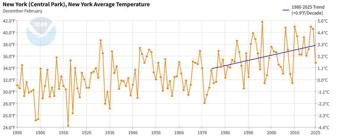
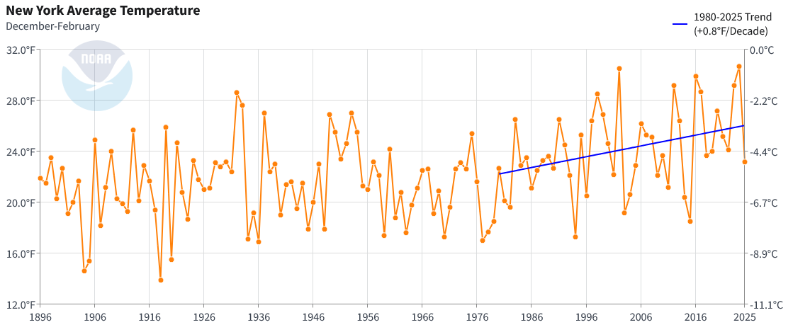
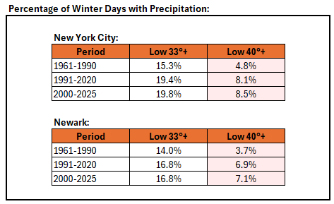
For some comparative statistics, New York City has been warming only slightly faster than New York State overall (0.9° per decade vs. 0.8° per decade) since 1980. That suggests that the overall share of the recent warming is due to broader changes in climate rather than the City's heat island effect. In any case, the frequency of above freezing low temperatures and above 40° low temperatures during winter precipitation events has been increasing. This applies to New York City and other nearby areas e.g., Newark. This could result in an increased frequency where light precipitation events could wind up having more rain than snow relative to earlier in the climate period. However, any structural decline in seasonal snowfall from an overall warming of winters probably won't be evident until the mid-2030s due to stochastic variability. Moreover, there will continue to be some big snowstorms (even if the recent big snowfall drought skews perceptions) and snowy winters. Winters can still feature cold. December 2025 is an example, as it's on course to be the coldest December in 15 years in NYC.


-
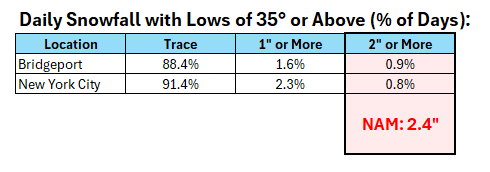
The combination of the warmth (the daily low temperature wound up at 35° in NYC), light precipitation rates, and warming at the mid-levels all suggested that the 2"+ NAM amount was unrealistic for the City. At that time, the forecast low was 33°-34°, but the NAM idea was unrealistic. With lows of 35° or above, a trace was by far the most likely outcome. The same would hold elsewhere in the NYC region at such an elevated low temperature. For example, below are the historical statistics for Bridgeport (1948-present) and New York City (1869-present): And here was the NAM map:
-
1869.
-
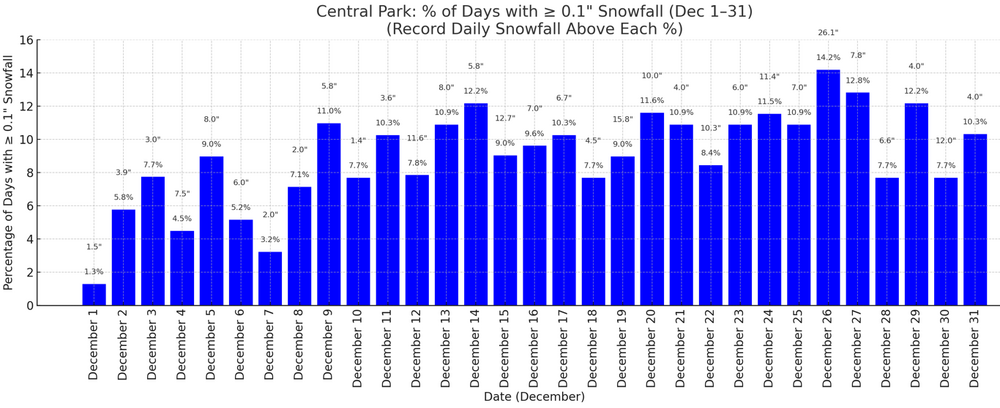
Boxing Day has December’s highest frequency of measurable snow days.
-
A weak system brought some light snow to the region. Snowfall amounts included: Armonk: 3.2" Bridgeport: Trace Islip: Trace Middletown: 5.0" New York City: Trace The snowfall in New York City was in line with historical data for systems with low temperatures above freezing. In New York City, only 25.6% of storms had seen measurable snowfall with a daily low of 33° or above with just 9.2% seeing 1" or more snowfall. Almost three-quarters (74.4%) of such events saw only a trace of snowfall. Today had a low temperature of 35°. 91.4% of snow events with a minimum temperature of 35° or above saw a trace of snow. Another system could bring precipitation on Friday into Saturday. This system could be a more substantial system with the potential for a plowable snowfall in the New York City region. No exceptionally cold or warm weather appears likely for the first week of astronomical winter. Nevertheless, the closing days of December will likely be colder than normal. December 2025 will likely finish with a maximum monthly temperature below 60° in New York City. The last time that happened was in 2019 when the monthly high was 58°. If 2025 has a monthly high below 60°, that would be only the fifth such occurrence since 2000 (2003, 2004, 2005, and 2019 are the cases since 2000). The ENSO Region 1+2 anomaly was -0.6°C and the Region 3.4 anomaly was -0.8°C for the week centered around December 17. For the past six weeks, the ENSO Region 1+2 anomaly has averaged -0.40°C and the ENSO Region 3.4 anomaly has averaged -0.68°C. La Niña conditions will likely continue through at least mid-winter. The SOI was +12.61 today. The preliminary Arctic Oscillation (AO) was +1.312 today. Based on sensitivity analysis applied to the latest guidance, there is an implied near 100% probability that New York City will have a cooler than normal December (1991-2020 normal). December will likely finish with a mean temperature near 34.0° (5.1° below normal). Supplemental Information: The projected mean would be 3.4° below the 1981-2010 normal monthly value.
-
4W Middletown is now up to 6.1".
-
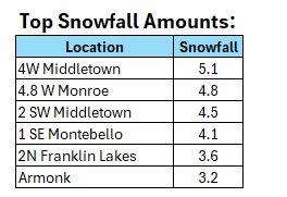
Highest snowfall amounts so far:
-
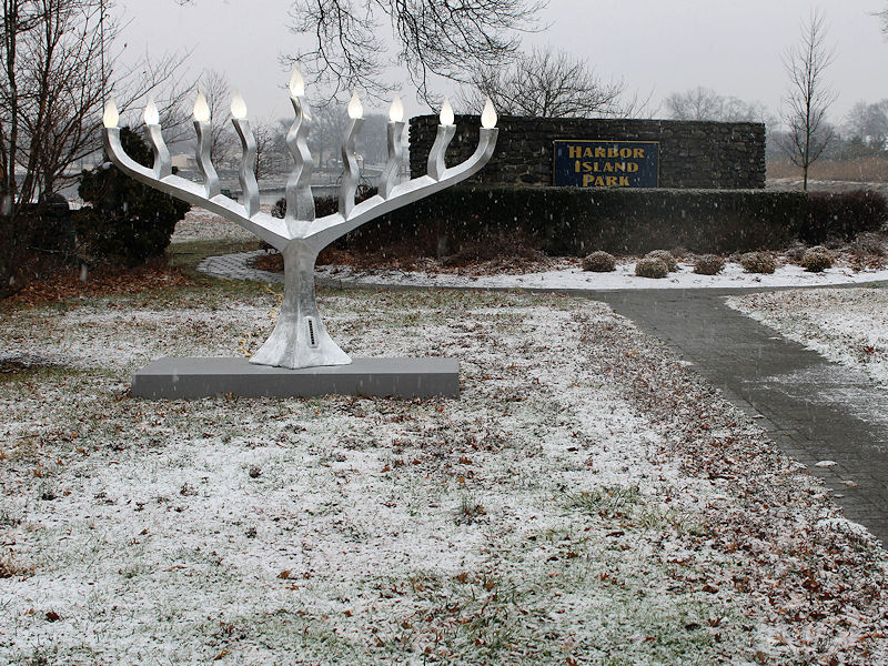
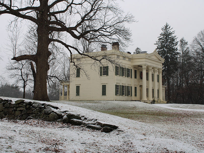
Two photos from this morning:
-
From Rye, NY: