

donsutherland1
-
Posts
23,761 -
Joined
Content Type
Profiles
Blogs
Forums
American Weather
Media Demo
Store
Gallery
Everything posted by donsutherland1
-
Morning thoughts… Earlier this morning, New York City picked up 0.49”. That brought the July total to 9.70”. As a result 2021 moved past 1897 when 9.56” of rain fell to become the 3rd wettest July on record. Today will be variably cloudy and more humid. Showers and thundershowers are possible this afternoon and evening. Temperatures will rise to the middle and upper 80s in most of the region. Likely high temperatures around the region include: New York City (Central Park): 83° Newark: 89° Philadelphia: 88° Normals: New York City: 30-Year: 85.1°; 15-Year: 86.2° Newark: 30-Year: 86.9°; 15-Year: 88.3° Philadelphia: 30-Year: 87.8°; 15-Year: 88.8° Tomorrow will be partly cloudy and very warm.
-
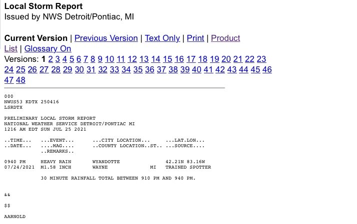
Tremendous downpour in Wyandotte last night.
-
A period of above to much above normal temperatures will develop starting tomorrow. Several days of above to much above normal readings are likely through mid-week. The ENSO Region 1+2 anomaly was +0.4°C and the Region 3.4 anomaly was -0.1°C for the week centered around July 14. For the past six weeks, the ENSO Region 1+2 anomaly has averaged 0.23°C and the ENSO Region 3.4 anomaly has averaged -0.12°C. Neutral ENSO conditions will likely prevail through August. The SOI was +16.19 today. The preliminary Arctic Oscillation (AO) figure was +0.685 today. On July 21 the MJO was in Phase 5 at an amplitude of 1.576 (RMM). The July 20-adjusted amplitude was 1.726 (RMM). In late April, the MJO moved through Phase 8 at an extreme amplitude (+3.000 or above). Only February 25, 1988 and March 18-19, 2015 had a higher amplitude at Phase 8. Both 1988 and 2015 went on to have an exceptionally warm July-August period. July-August 1988 had a mean temperature of 79.1°, which ranked 4th highest for that two-month period. July-August 2015 had a mean temperature of 78.9°, which ranked 5th highest for that two-month period. September 2015 was also the warmest September on record. The MJO's extreme passage through Phase 8 could provide the first hint of a hot summer. Since 1896, 76% of years that saw Phoenix reach 115° or above in June, as occurred this year, had a warmer than July-August in the Middle Atlantic region. The ratio of top 30 July-August temperatures relative to bottom 30 temperatures was 6:1 in favor of the warmth. Overall, the ingredients continue to fall into place for a warmer than normal to potentially hot summer. Based on sensitivity analysis applied to the latest guidance, there is an implied 78% probability that New York City will have a cooler than normal July (1991-2020 normal). July will likely finish with a mean temperature near 76.7° (0.8° below normal).
-
Under partly sunny skies, the temperature rose into the lower 80s at the New York Botanical Garden.


-
Morning thoughts… Today will be partly sunny and a bit warmer than yesterday. Humidity will still be fairly low and temperatures will rise to the lower and middle 80s in most of the region. Likely high temperatures around the region include: New York City (Central Park): 82° Newark: 86° Philadelphia: 86° Normals: New York City: 30-Year: 85.2°; 15-Year: 86.3° Newark: 30-Year: 86.9°; 15-Year: 88.3° Philadelphia: 30-Year: 87.8°; 15-Year: 88.9° Tomorrow will be variably cloudy and warmer. A shower or thundershower is possible. In the Southwest, a retrograding system will produce additional significant monsoon rainfall.
-
A period of mainly dry conditions and somewhat cooler than normal temperatures will continue into the weekend. Afterward, there are growing model indications that a period of above to much above normal temperatures could develop. Tomorrow will be partly sunny with temperatures in the lower and middle 80s. However, the heat will be creeping northward and the temperature could reach or exceed 90° in Baltimore and/or Washington, DC. Out West, the ongoing monsoon event is the big weather story. Through 8 pm, Phoenix had received 0.79" of rain, which exceeded the daily record of 0.41" from 2002. Even more impressive, the high temperature through 8 pm was 83°, which would be the coldest maximum temperature since July 31, 1964. In addition, several July hourly low temperature marks were set. In the long-range, August could wind up warmer to perhaps much warmer than normal based on the evolution of the MJO. The MJO was in Phase 1 with an amplitude between 1.500 and 2.000 on multiple days during the June 20-30 period. There were 8 prior cases similar to 2021. mean temperature for August was 77.1° following such cases. The 1991-20 mean temperature for was 76.0° for August. 88% of the August cases were warmer than the 1991-20 mean temperatures. Early prospects for a very warm second half of July have diminished on account of the MJO's having moved back into Phase 2 from Phase 3. The ENSO Region 1+2 anomaly was +0.4°C and the Region 3.4 anomaly was -0.1°C for the week centered around July 14. For the past six weeks, the ENSO Region 1+2 anomaly has averaged 0.23°C and the ENSO Region 3.4 anomaly has averaged -0.12°C. Neutral ENSO conditions will likely prevail through August. The SOI was +17.85 today. The preliminary Arctic Oscillation (AO) figure was +0.743 today. On July 20 the MJO was in Phase 5 at an amplitude of 1.738 (RMM). The July 19-adjusted amplitude was 1.805 (RMM). In late April, the MJO moved through Phase 8 at an extreme amplitude (+3.000 or above). Only February 25, 1988 and March 18-19, 2015 had a higher amplitude at Phase 8. Both 1988 and 2015 went on to have an exceptionally warm July-August period. July-August 1988 had a mean temperature of 79.1°, which ranked 4th highest for that two-month period. July-August 2015 had a mean temperature of 78.9°, which ranked 5th highest for that two-month period. September 2015 was also the warmest September on record. The MJO's extreme passage through Phase 8 could provide the first hint of a hot summer. Since 1896, 76% of years that saw Phoenix reach 115° or above in June, as occurred this year, had a warmer than July-August in the Middle Atlantic region. The ratio of top 30 July-August temperatures relative to bottom 30 temperatures was 6:1 in favor of the warmth. Overall, the ingredients continue to fall into place for a warmer than normal to potentially hot summer. Based on sensitivity analysis applied to the latest guidance, there is an implied 69% probability that New York City will have a cooler than normal July (1991-2020 normal). July will likely finish with a mean temperature near 76.8° (0.7° below normal).
-
Morning thoughts… Today will be partly sunny and comfortable. Humidity will be low and temperatures will rise to the lower and perhaps middle 80s in most of the region. Likely high temperatures around the region include: New York City (Central Park): 82° Newark: 85° Philadelphia: 84° Normals: New York City: 30-Year: 85.2°; 15-Year: 86.3° Newark: 30-Year: 87.0°; 15-Year: 88.4° Philadelphia: 30-Year: 87.9°; 15-Year: 89.0° Tomorrow will be partly sunny and continued pleasant. In the Southwest, a retrograding system will produce significant monsoon rainfall, with the heaviest amounts falling through tomorrow morning. Both Phoenix and Tucson could pick up 0.50”-1.00” rain during this by the end of tomorrow. Already, Phoenix has received 0.21” of rain.
-
A period of mainly dry conditions and somewhat cooler than normal temperatures will continue into the weekend. Afterward, there are growing model indications that a period of above to much above normal temperatures could develop. In the long-range, August could wind up warmer to perhaps much warmer than normal based on the evolution of the MJO. The MJO was in Phase 1 with an amplitude between 1.500 and 2.000 on multiple days during the June 20-30 period. There were 8 prior cases similar to 2021. mean temperature for August was 77.1° following such cases. The 1991-20 mean temperature for was 76.0° for August. 88% of the August cases were warmer than the 1991-20 mean temperatures. Early prospects for a very warm second half of July have diminished on account of the MJO's having moved back into Phase 2 from Phase 3. The ENSO Region 1+2 anomaly was +0.4°C and the Region 3.4 anomaly was -0.1°C for the week centered around July 14. For the past six weeks, the ENSO Region 1+2 anomaly has averaged 0.23°C and the ENSO Region 3.4 anomaly has averaged -0.12°C. Neutral ENSO conditions will likely prevail through August. The SOI was +16.50 today. The preliminary Arctic Oscillation (AO) figure was +0.951 today. On July 20 the MJO was in Phase 5 at an amplitude of 1.812 (RMM). The July 19-adjusted amplitude was 1.718 (RMM). In late April, the MJO moved through Phase 8 at an extreme amplitude (+3.000 or above). Only February 25, 1988 and March 18-19, 2015 had a higher amplitude at Phase 8. Both 1988 and 2015 went on to have an exceptionally warm July-August period. July-August 1988 had a mean temperature of 79.1°, which ranked 4th highest for that two-month period. July-August 2015 had a mean temperature of 78.9°, which ranked 5th highest for that two-month period. September 2015 was also the warmest September on record. The MJO's extreme passage through Phase 8 could provide the first hint of a hot summer. Since 1896, 76% of years that saw Phoenix reach 115° or above in June, as occurred this year, had a warmer than July-August in the Middle Atlantic region. The ratio of top 30 July-August temperatures relative to bottom 30 temperatures was 6:1 in favor of the warmth. Overall, the ingredients continue to fall into place for a warmer than normal to potentially hot summer. Based on sensitivity analysis applied to the latest guidance, there is an implied 68% probability that New York City will have a cooler than normal July (1991-2020 normal). July will likely finish with a mean temperature near 76.8° (0.7° below normal).
-
Morning thoughts… Today will be partly sunny and refreshing. Humidity will be low and temperatures will rise to the lower and perhaps middle 80s in most of the region. Likely high temperatures around the region include: New York City (Central Park): 82° Newark: 87° Philadelphia: 83° Normals: New York City: 30-Year: 85.2°; 15-Year: 86.4° Newark: 30-Year: 87.1°; 15-Year: 88.5° Philadelphia: 30-Year: 87.9°; 15-Year: 89.0° Tomorrow will be partly sunny and pleasant. In the Southwest, a retrograding system will produce significant monsoon rainfall, with the heaviest amounts falling between tomorrow night and Saturday morning. Both Phoenix and Tucson could pick up 0.50”-1.00” rain during this period.
-
Following the cold front's passage, a period of mainly dry conditions and somewhat cooler than normal temperatures will continue into the weekend. Afterward, there are growing model indications that a period of above to much above normal temperatures could develop. In the long-range, August could wind up warmer to perhaps much warmer than normal based on the evolution of the MJO. The MJO was in Phase 1 with an amplitude between 1.500 and 2.000 on multiple days during the June 20-30 period. There were 8 prior cases similar to 2021. mean temperature for August was 77.1° following such cases. The 1991-20 mean temperature for was 76.0° for August. 88% of the August cases were warmer than the 1991-20 mean temperatures. Early prospects for a very warm second half of July have diminished on account of the MJO's having moved back into Phase 2 from Phase 3. The ENSO Region 1+2 anomaly was +0.4°C and the Region 3.4 anomaly was -0.1°C for the week centered around July 14. For the past six weeks, the ENSO Region 1+2 anomaly has averaged 0.23°C and the ENSO Region 3.4 anomaly has averaged -0.12°C. Neutral ENSO conditions will likely prevail through August. The SOI was +8.80 today. The preliminary Arctic Oscillation (AO) figure was +0.938 today. On July 19 the MJO was in Phase 5 at an amplitude of 1.718 (RMM). The July 18-adjusted amplitude was 1.711 (RMM). In late April, the MJO moved through Phase 8 at an extreme amplitude (+3.000 or above). Only February 25, 1988 and March 18-19, 2015 had a higher amplitude at Phase 8. Both 1988 and 2015 went on to have an exceptionally warm July-August period. July-August 1988 had a mean temperature of 79.1°, which ranked 4th highest for that two-month period. July-August 2015 had a mean temperature of 78.9°, which ranked 5th highest for that two-month period. September 2015 was also the warmest September on record. The MJO's extreme passage through Phase 8 could provide the first hint of a hot summer. Since 1896, 76% of years that saw Phoenix reach 115° or above in June, as occurred this year, had a warmer than July-August in the Middle Atlantic region. The ratio of top 30 July-August temperatures relative to bottom 30 temperatures was 6:1 in favor of the warmth. Overall, the ingredients continue to fall into place for a warmer than normal to potentially hot summer. Based on sensitivity analysis applied to the latest guidance, there is an implied 64% probability that New York City will have a cooler than normal July (1991-2020 normal). July will likely finish with a mean temperature near 76.9° (0.6° below normal).
-
Morning thoughts… Smoke from the western wildfires will again dim the sunshine. It will be hazy and very warm with highs in middle and upper 80s in most of the region. Parts of the area could see a thunderstorm during the afternoon or evening as a cold front pushes across the region. Likely high temperatures around the region include: New York City (Central Park): 84° Newark: 88° Philadelphia: 87° Normals: New York City: 30-Year: 85.2°; 15-Year: 86.4° Newark: 30-Year: 87.1°; 15-Year: 88.5° Philadelphia: 30-Year: 88.0°; 15-Year: 89.1° Tomorrow will be partly sunny and somewhat cooler.
-
Tomorrow will be another very warm day with temperatures rising into upper 80s and lower 90s. The day could end with thunderstorms and heavy downpours as a cold front moves across the region. Afterward, a period of mainly dry conditions and somewhat cooler than normal temperatures will continue into the weekend. Afterward, there are growing model indications that a period of above to much above normal temperatures could develop. In the long-range, August could wind up warmer to perhaps much warmer than normal based on the evolution of the MJO. The MJO was in Phase 1 with an amplitude between 1.500 and 2.000 on multiple days during the June 20-30 period. There were 8 prior cases similar to 2021. mean temperature for August was 77.1° following such cases. The 1991-20 mean temperature for was 76.0° for August. 88% of the August cases were warmer than the 1991-20 mean temperatures. Early prospects for a very warm second half of July have diminished on account of the MJO's having moved back into Phase 2 from Phase 3. The ENSO Region 1+2 anomaly was +0.4°C and the Region 3.4 anomaly was -0.1°C for the week centered around July 14. For the past six weeks, the ENSO Region 1+2 anomaly has averaged 0.23°C and the ENSO Region 3.4 anomaly has averaged -0.12°C. Neutral ENSO conditions will likely prevail through August. The SOI was +8.86 today. The preliminary Arctic Oscillation (AO) figure was +0.881 today. On July 18 the MJO was in Phase 5 at an amplitude of 1.707 (RMM). The July 17-adjusted amplitude was 1.320 (RMM). In late April, the MJO moved through Phase 8 at an extreme amplitude (+3.000 or above). Only February 25, 1988 and March 18-19, 2015 had a higher amplitude at Phase 8. Both 1988 and 2015 went on to have an exceptionally warm July-August period. July-August 1988 had a mean temperature of 79.1°, which ranked 4th highest for that two-month period. July-August 2015 had a mean temperature of 78.9°, which ranked 5th highest for that two-month period. September 2015 was also the warmest September on record. The MJO's extreme passage through Phase 8 could provide the first hint of a hot summer. Since 1896, 76% of years that saw Phoenix reach 115° or above in June, as occurred this year, had a warmer than July-August in the Middle Atlantic region. The ratio of top 30 July-August temperatures relative to bottom 30 temperatures was 6:1 in favor of the warmth. Overall, the ingredients continue to fall into place for a warmer than normal to potentially hot summer. Based on sensitivity analysis applied to the latest guidance, there is an implied 61% probability that New York City will have a cooler than normal July (1991-2020 normal). July will likely finish with a mean temperature near 77.0° (0.5° below normal).
-
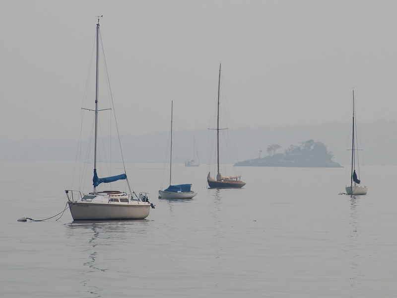
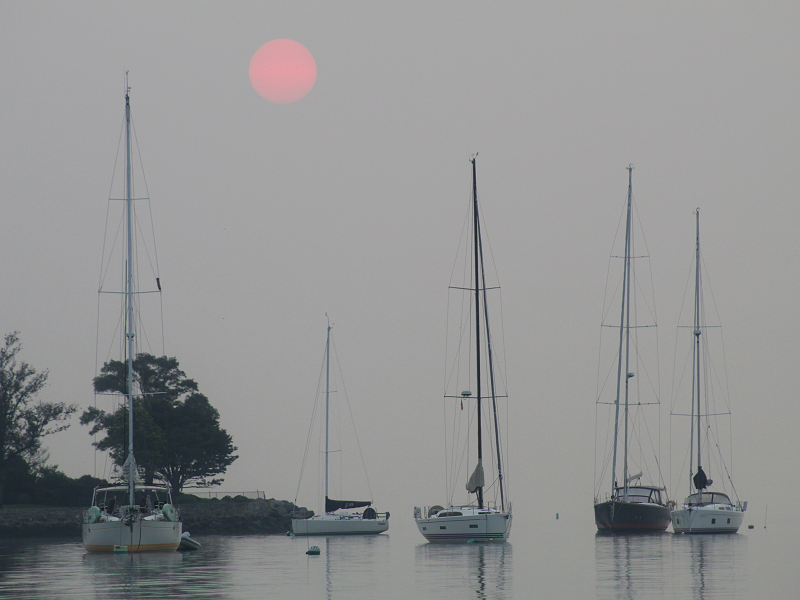
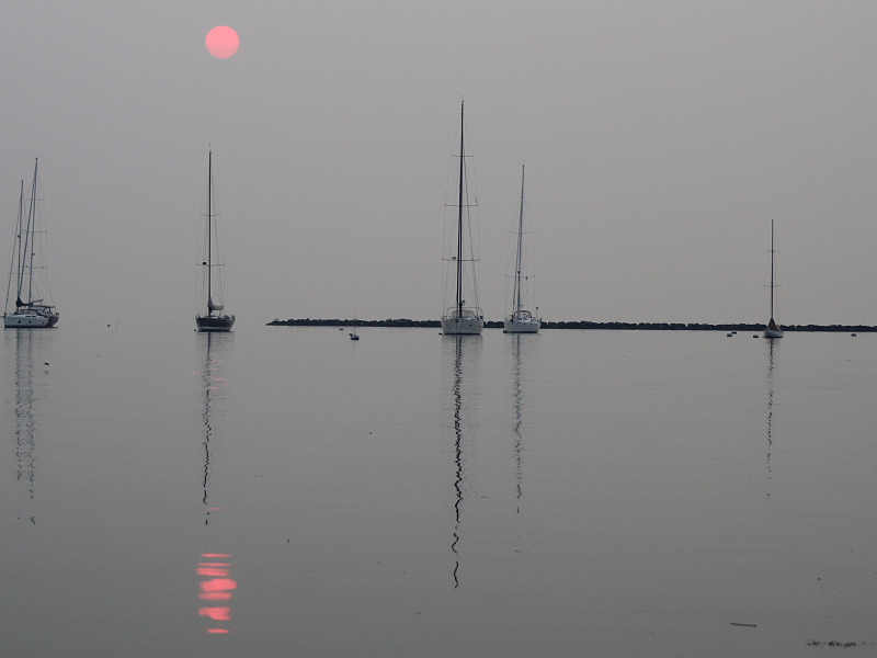
Four photos from early this evening. visibility was probably around 2 1/2 miles on the Long Island Sound due to the smoke and haze.


-
This is a terrific photo and the reflection is great.
-
Morning thoughts… Smoke from the western wildfires will dim the sunshine. It will be hazy and very warm with highs in the upper 80s and lower 90s in most of the region. Likely high temperatures around the region include: New York City (Central Park): 88° Newark: 93° Philadelphia: 91° Normals: New York City: 30-Year: 85.3°; 15-Year: 86.4° Newark: 30-Year: 87.2°; 15-Year: 88.5° Philadelphia: 30-Year: 88.0°; 15-Year: 89.1° Tomorrow will be partly sunny and very warm. Some thunderstorms are possible late in the day or at night.
-
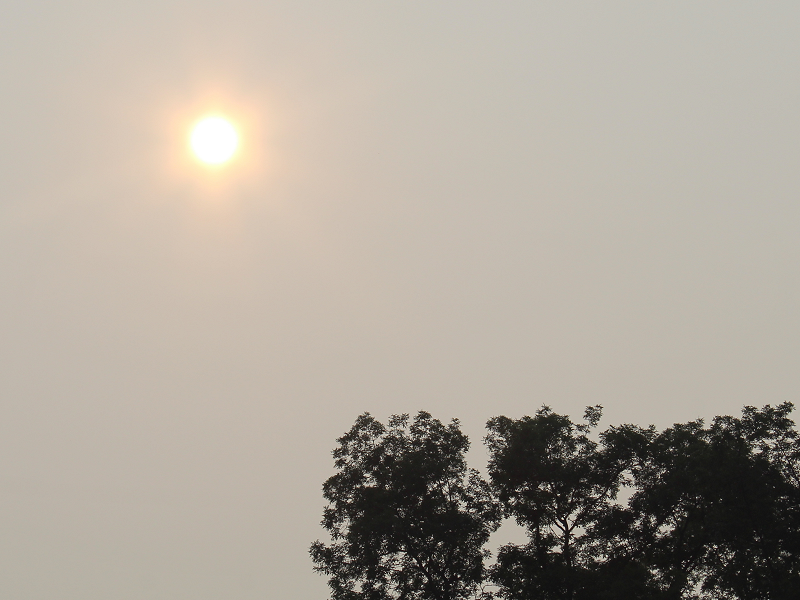
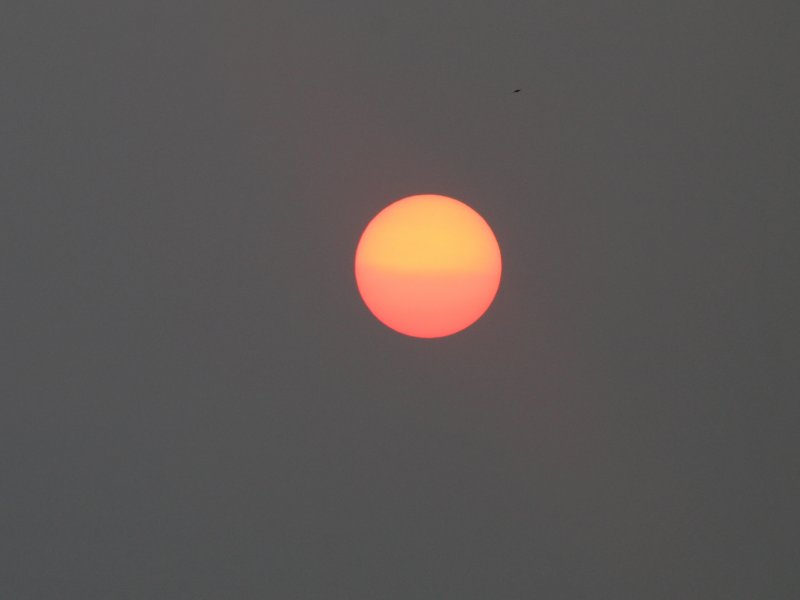
Sunrise through the thick wildfire smoke:
-
This is another bad break on the climate change front. There had been some hope that cloud changes could somewhat dampen the warming. Research by Jessica Tierney et al., hinted at amplification from the paleoclimate record, but there was no direct evidence. This paper provides that evidence. Its findings underscore the urgency of moving faster rather than more slowly in curbing greenhouse gas emissions.
-
Clouds broke during the afternoon and temperatures rose into the upper 70s and lower to middle 80s. In Montana, extreme heat prevailed. Glasgow reached 110°, which broke the daily record of 107° from 1941. The 110° temperature was the 3rd highest on record. At Boise, the overnight low temperature was 80°. The previous daily record high minimum temperature was 72°, which was set in 1877 and tied in 1918 and 2009. Tomorrow will feature hazy sunshine and very warm temperatures. The haze will be the result of wildfires burning in the U.S. and Canadian West. Temperatures will surge into the upper 80s and lower 90s. In the long-range, August could wind up warmer to perhaps much warmer than normal based on the evolution of the MJO. The MJO was in Phase 1 with an amplitude between 1.500 and 2.000 on multiple days during the June 20-30 period. There were 8 prior cases similar to 2021. mean temperature for August was 77.1° following such cases. The 1991-20 mean temperature for was 76.0° for August. 88% of the August cases were warmer than the 1991-20 mean temperatures. Early prospects for a very warm second half of July have diminished on account of the MJO's having moved back into Phase 2 from Phase 3. The ENSO Region 1+2 anomaly was +0.4°C and the Region 3.4 anomaly was -0.1°C for the week centered around July 14. For the past six weeks, the ENSO Region 1+2 anomaly has averaged 0.23°C and the ENSO Region 3.4 anomaly has averaged -0.12°C. Neutral ENSO conditions will likely prevail through August. The SOI was +8.80 today. The preliminary Arctic Oscillation (AO) figure was +0.722 today. On July 17 the MJO was in Phase 4 at an amplitude of 1.307 (RMM). The July 16-adjusted amplitude was 0.999 (RMM). In late April, the MJO moved through Phase 8 at an extreme amplitude (+3.000 or above). Only February 25, 1988 and March 18-19, 2015 had a higher amplitude at Phase 8. Both 1988 and 2015 went on to have an exceptionally warm July-August period. July-August 1988 had a mean temperature of 79.1°, which ranked 4th highest for that two-month period. July-August 2015 had a mean temperature of 78.9°, which ranked 5th highest for that two-month period. September 2015 was also the warmest September on record. The MJO's extreme passage through Phase 8 could provide the first hint of a hot summer. Since 1896, 76% of years that saw Phoenix reach 115° or above in June, as occurred this year, had a warmer than July-August in the Middle Atlantic region. The ratio of top 30 July-August temperatures relative to bottom 30 temperatures was 6:1 in favor of the warmth. Overall, the ingredients continue to fall into place for a warmer than normal to potentially hot summer. Based on sensitivity analysis applied to the latest guidance, there is an implied 60% probability that New York City will have a cooler than normal July (1991-2020 normal). July will likely finish with a mean temperature near 76.9° (0.6° below normal).
-
Both were 3 sigma events.
-
What happened in Seattle was just over 4 sigma above the normal high temperature. The 108F peak temperature there would be the equivalent of 112F in Central Park.
-
Morning thoughts… Today will become partly to mostly sunny and warm. Temperatures will likely reach the lower and middle 80s in most of the region. A few locations could see upper 80s. Likely high temperatures around the region include: New York City (Central Park): 84° Newark: 88° Philadelphia: 87° Normals: New York City: 30-Year: 85.3°; 15-Year: 86.4° Newark: 30-Year: 87.2°; 15-Year: 88.6° Philadelphia: 30-Year: 88.1°; 15-Year: 89.1° Tomorrow will be partly sunny and very warm.
-
Tomorrow will be partly sunny and pleasantly warm. Temperatures will again surge into the upper 80s and lower 90s on Tuesday and Wednesday before the next cold front crosses the region. In the long-range, August could wind up warmer to perhaps much warmer than normal based on the evolution of the MJO. The MJO was in Phase 1 with an amplitude between 1.500 and 2.000 on multiple days during the June 20-30 period. There were 8 prior cases similar to 2021. mean temperature for August was 77.1° following such cases. The 1991-20 mean temperature for was 76.0° for August. 88% of the August cases were warmer than the 1991-20 mean temperatures. Early prospects for a very warm second half of July have diminished on account of the MJO's having moved back into Phase 2 from Phase 3. The ENSO Region 1+2 anomaly was +0.1°C and the Region 3.4 anomaly was 0.0°C for the week centered around July 7. For the past six weeks, the ENSO Region 1+2 anomaly has averaged 0.10°C and the ENSO Region 3.4 anomaly has averaged -0.13°C. Neutral ENSO conditions will likely prevail through August. The SOI was +17.30 today. The preliminary Arctic Oscillation (AO) figure was +0.791 today. On July 16 the MJO was in Phase 4 at an amplitude of 0.995 (RMM). The July 15-adjusted amplitude was 0.970 (RMM). In late April, the MJO moved through Phase 8 at an extreme amplitude (+3.000 or above). Only February 25, 1988 and March 18-19, 2015 had a higher amplitude at Phase 8. Both 1988 and 2015 went on to have an exceptionally warm July-August period. July-August 1988 had a mean temperature of 79.1°, which ranked 4th highest for that two-month period. July-August 2015 had a mean temperature of 78.9°, which ranked 5th highest for that two-month period. September 2015 was also the warmest September on record. The MJO's extreme passage through Phase 8 could provide the first hint of a hot summer. Since 1896, 76% of years that saw Phoenix reach 115° or above in June, as occurred this year, had a warmer than July-August in the Middle Atlantic region. The ratio of top 30 July-August temperatures relative to bottom 30 temperatures was 6:1 in favor of the warmth. Overall, the ingredients continue to fall into place for a warmer than normal to potentially hot summer. Based on sensitivity analysis applied to the latest guidance, there is an implied 65% probability that New York City will have a cooler than normal July (1991-2020 normal). July will likely finish with a mean temperature near 76.8° (0.7° below normal).
-
What happened in the Pacific Northwest was unprecedented. There will be extreme heat in our region at some point. Things are warming and eventually it will happen. I would be surprised if it didn’t happen this decade.
-
All measures are important in providing a full picture of the climate. Outside of the increasingly dense “forest” in Central Park mean summer high temperatures are rising.
-
Morning thoughts… With rainfall through 8 am, July rainfall in New York City has reached 9.14”. That makes 2021 the 4th wettest July on record. At 8:30, a few small showers were working northeastward in northern New Jersey. Any rain will end this morning. The clouds could break during the afternoon. It will be cooler than yesterday. Temperatures will likely reach the lower and middle 80s in most of the region. Likely high temperatures around the region include: New York City (Central Park): 83° Newark: 87° Philadelphia: 83° Normals: New York City: 30-Year: 85.3°; 15-Year: 86.4° Newark: 30-Year: 87.2°; 15-Year: 88.6° Philadelphia: 30-Year: 88.1°; 15-Year: 89.2° Tomorrow will be partly sunny and pleasant.

