donsutherland1
-
Posts
23,372 -
Joined
Content Type
Profiles
Blogs
Forums
American Weather
Media Demo
Store
Gallery
Everything posted by donsutherland1
-
Central Park has 3-day rainfall of 8.05” through 10 am.
- 1,603 replies
-
- 2
-

-
- hurricane gusts
- flooding rains
- (and 2 more)
-
Yes. That’s correct.
-
Morning thoughts… More August rainfall records are being washed away at Central Park this morning… The August 21-22, 2021 rainfall total of 7.12” swept away the old 2-day August record of 6.87”, which was set during August 27-28, 2011. Through 7 am EDT, New York City’s 3-day total had reached 7.92”. That easily surpasses the old 3-day August mark of 7.20”, which was set during August 11-13, 1955. Additional rain and showers are likely in the northern Middle Atlantic region and southern New England as Henri gradually moves away from the region. Farther south, clouds will break this morning. New York City could see clouds break during the afternoon or evening. High temperatures will likely reach the upper 70s to middle 80s in most of the region. Likely high temperatures around the region include: New York City (Central Park): 79° Newark: 85° Philadelphia: 86° Normals: New York City: 30-Year: 82.6°; 15-Year: 82.3° Newark: 30-Year: 84.0°; 15-Year: 84.0° Philadelphia: 30-Year: 85.0°; 15-Year: 84.7° Tomorrow mostly sunny and very warm.
-
That source is way off for today’s rainfall. At 4 pm, the daily climate summary showed 1.90”. More fell since then. 000 CDUS41 KOKX 222034 CLINYC CLIMATE REPORT NATIONAL WEATHER SERVICE NEW YORK, NY 434 PM EDT SUN AUG 22 2021 ................................... ...THE CENTRAL PARK NY CLIMATE SUMMARY FOR AUGUST 22 2021... VALID TODAY AS OF 0400 PM LOCAL TIME. CLIMATE NORMAL PERIOD 1991 TO 2020 CLIMATE RECORD PERIOD 1869 TO 2021 WEATHER ITEM OBSERVED TIME RECORD YEAR NORMAL DEPARTURE LAST VALUE (LST) VALUE VALUE FROM YEAR NORMAL ................................................................... TEMPERATURE (F) TODAY MAXIMUM 76 408 AM 95 1916 83 -7 88 MINIMUM 71 253 PM 52 1895 68 3 73 AVERAGE 74 76 -2 81 PRECIPITATION (IN) TODAY 1.90R 1.85 1994 0.14 1.76 T MONTH TO DATE 7.81 3.31 4.50 4.24 SINCE JUN 1 21.52 12.45 9.07 12.58 SINCE JAN 1 39.42 31.62 7.80 26.97
-
There will probably be a pause in NYC until Henri starts heading east again.
- 1,603 replies
-
- 2
-
-
- hurricane gusts
- flooding rains
- (and 2 more)
-
The generated chart is what is in the database. I am not sure where the differences arise.
- 1,603 replies
-
- 1
-

-
- hurricane gusts
- flooding rains
- (and 2 more)
-
New York City's Central Park received its largest 2-day August rainfall on record. Through 8 pm, 7.04" had fallen. That broke the previous 2-day August record of 6.87", which was set on August 27-28, 2011. In addition, Central Park set a new hourly mark of 1.94" rain yesterday. Daily rainfall records included: Hartford: 3.15" (old record: 1.95", 1937) New York City-JFK: 2.26" (old record: 2.00", 1994) New York City-NYC: 2.59" (old record: 1.85", 1994) Newark: 2.39" (old record: 1.70", 1994) Tomorrow will see clouds break for sunshine. It will turn noticeably warmer. There could still be a shower or thunderstorm. The ENSO Region 1+2 anomaly was +0.1°C and the Region 3.4 anomaly was -0.4°C for the week centered around August 11. For the past six weeks, the ENSO Region 1+2 anomaly has averaged +0.45°C and the ENSO Region 3.4 anomaly has averaged -0.28°C. Neutral ENSO conditions will likely prevail into mid-September. The SOI was +3.46 today. The preliminary Arctic Oscillation (AO) figure was -0.833 today. On August 20 the MJO was in Phase 2 at an amplitude of 1.447 (RMM). The August 19-adjusted amplitude was 1.637 (RMM). Based on sensitivity analysis applied to the latest guidance, there is an implied 83% probability that New York City will have a warmer than normal August (1991-2020 normal). August will likely finish with a mean temperature near 77.3° (1.3° above normal).
-
No. From 10-11 pm, 1.38” fell. From 11 pm-midnight 1.94” fell.
- 1,603 replies
-
- 1
-
-
- hurricane gusts
- flooding rains
- (and 2 more)
-
Large parts of the parkway are now flooded.
- 1,603 replies
-
- 1
-

-
- hurricane gusts
- flooding rains
- (and 2 more)
-
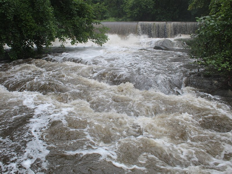
A normally quiet section of the Bronx River in Scarsdale, NY:
- 1,603 replies
-
- 6
-
-
- hurricane gusts
- flooding rains
- (and 2 more)
-
It has happened once. March 1983: 10.54” and April 1983: 14.01”
- 1,603 replies
-
- 3
-
-
- hurricane gusts
- flooding rains
- (and 2 more)
-
Through 4 pm, Central Park’s 2-day rainfall is 6.29”. That is the 4th highest 2-day figure on record for August.
-
With 0.39” rainfall through 11 am, Summer 2021 has become only the 10th on record to record 20” or more of rain in New York City.
- 1,603 replies
-
- 2
-
-
- hurricane gusts
- flooding rains
- (and 2 more)
-
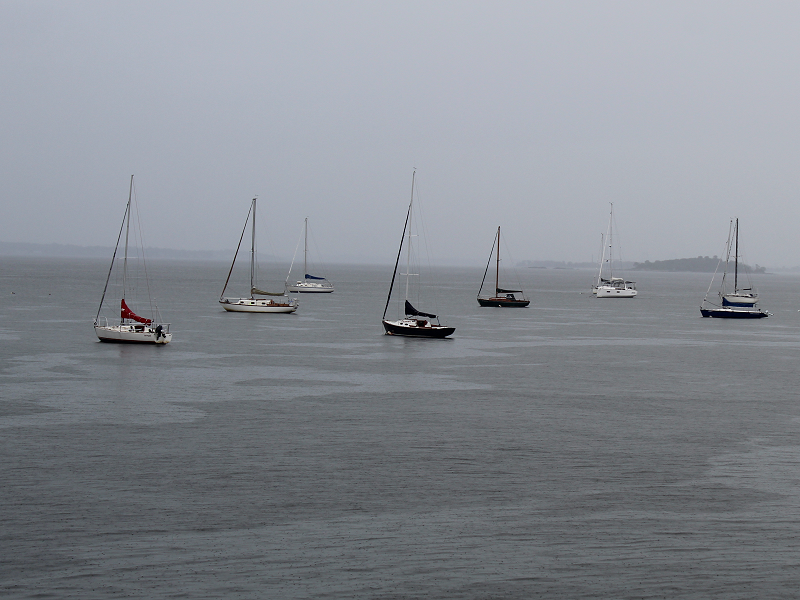
A steady rain and light breeze on the Long Island Sound in southern Westchester County.
- 1,603 replies
-
- 3
-
-
- hurricane gusts
- flooding rains
- (and 2 more)
-
Occasional Thoughts on Climate Change
donsutherland1 replied to donsutherland1's topic in Climate Change
This is also why the NOAA makes adjustments as necessary e.g., through its homogenization process. Otherwise, data would not really be consistent or comparable. -
Morning thoughts… Last night was a historic night in Central Park. For the first time on record, 1.35” or more rain fell for two consecutive hours, including a new hourly record figure of 1.94”. 2021 also recorded its record 3rd day of the year with an hourly amount of 1.35” or more. Total rainfall came to 4.45”, which broke the daily record of 4.19” from 1888 and was the 5th highest daily figure on record for August. Henri will pass east of Long Island before making landfall in Rhode Island. It will be mostly cloudy, windy, with rain. Heavy downpours are likely. High temperatures will likely reach the upper 70s and lower 80s in most of the region. Likely high temperatures around the region include: New York City (Central Park): 77° Newark: 80° Philadelphia: 81° Normals: New York City: 30-Year: 82.8°; 15-Year: 82.5° Newark: 30-Year: 84.1°; 15-Year: 84.1° Philadelphia: 30-Year: 85.2°; 15-Year: 84.9° Tomorrow will be variably cloudy, breezy, and warmer. Showers and thundershowers are still possible. For reference, daily rainfall records for select locations are below: Bridgeport: 1.42”, 1994 Farmingdale: 0.89”, 2019 Hartford: 1.95”, 1937 Islip: 2.21”, 1977 New Haven: 2.25”, 2010 New York City-JFK: 2.00”, 1994 New York City-LGA: 2.34”, 1994 New York City-NYC: 1.85”, 1994 Newark: 1.70”, 1994 Poughkeepsie: 3.70”, 2010 Westhampton: 1.41”, 1952 White Plains: 3.04”, 2010
-
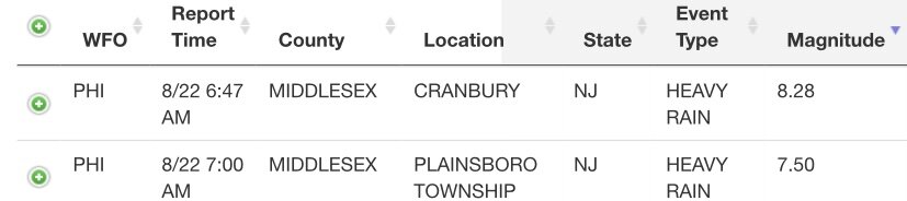
000 NOUS41 KOKX 220615 PNSOKX CTZ005>012-NJZ002-004-006-103>108-NYZ067>075-078>081-176>179-221815- Public Information Statement National Weather Service New York NY 215 AM EDT Sun Aug 22 2021 ...Latest Rainfall Reports Through 2AM... Location Amount Time/Date Provider ...New Jersey... ...Bergen County... Hasbrouck Heights 3.05 in 0109 AM 08/22 CWOP Teterboro Airport 2.40 in 0106 AM 08/22 ASOS Lodi 2.16 in 1245 AM 08/22 IFLOWS Little Ferry 1.93 in 0110 AM 08/22 AWS Leonia 1.52 in 0110 AM 08/22 AWS Tenafly 1.39 in 1256 AM 08/22 CWOP Bogota 1.33 in 0110 AM 08/22 AWS New Milford 1.19 in 0105 AM 08/22 AWS Fair Lawn 1.13 in 0110 AM 08/22 CWOP ...Essex County... 0.6 SW Caldwell 2.48 in 1245 AM 08/22 IFLOWS West Orange 2.18 in 0104 AM 08/22 CWOP Montclair 2.15 in 0110 AM 08/22 AWS West Caldwell 2.13 in 0105 AM 08/22 CWOP Caldwell 1.97 in 0100 AM 08/22 ASOS Fairfield 1.78 in 0110 AM 08/22 AWS Bloomfield 1.78 in 0105 AM 08/22 CWOP Maplewood 1.20 in 0100 AM 08/22 IFLOWS Livingston 1.17 in 0102 AM 08/22 CWOP ...Hudson County... Jersey City 3.64 in 0109 AM 08/22 AWS 1 ENE Jersey City 3.43 in 0110 AM 08/22 AWS 1 SW Jersey City 3.20 in 0110 AM 08/22 AWS 1 W Hoboken 3.05 in 0110 AM 08/22 AWS Harrison 2.91 in 1100 PM 08/21 COOP Secaucus 2.85 in 0110 AM 08/22 AWS Hoboken 2.71 in 0107 AM 08/22 CWOP Weehawken 2.54 in 0110 AM 08/22 AWS Kearny 2.28 in 0110 AM 08/22 CWOP Kearny 2.14 in 0105 AM 08/22 CWOP 1 W Hoboken 2.03 in 1110 PM 08/21 AWS Bayonne 1.15 in 0110 AM 08/22 AWS Harrison 1.07 in 0110 AM 08/22 AWS ...Passaic County... Passaic 3.19 in 0102 AM 08/22 CWOP Clifton 2.87 in 0105 AM 08/22 AWS 0.8 E West Paterson 1.92 in 1245 AM 08/22 HADS 0.9 S Wayne 1.76 in 1245 AM 08/22 IFLOWS ...Union County... Newark Airport 1.45 in 0115 AM 08/22 ASOS ...New York... ...Bronx County... 1 ENE East Tremont 2.66 in 1130 PM 08/21 Trained Spotter Harlem 1.24 in 0110 AM 08/22 AWS ...Kings County... Brooklyn 6.32 in 0105 AM 08/22 CWOP Prospect Park 5.24 in 0105 AM 08/22 AWS 1 ESE Battery Park 5.23 in 0150 AM 08/22 Mesonet South Slope 5.04 in 0106 AM 08/22 CWOP Sheepshead Bay 4.41 in 0101 AM 08/22 CWOP 1 SSW Flatbush 4.32 in 0150 AM 08/22 Mesonet Flatbush 4.11 in 0150 AM 08/22 Mesonet 1 E Crown Heights 4.07 in 0151 AM 08/22 Mesonet Brooklyn College 4.06 in 0110 AM 08/22 NYSM 2 NE Coney Island 3.75 in 1245 AM 08/22 Trained Spotter ...Nassau County... Great Neck 2.62 in 1106 PM 08/21 CWOP Thomaston 2.33 in 1109 PM 08/21 AWS Mineola 2.04 in 1110 PM 08/21 AWS Carle Place 1.79 in 1110 PM 08/21 CWOP Levittown 1.77 in 1100 PM 08/21 CWOP Massapequa Park 1.57 in 1101 PM 08/21 CWOP East Rockaway 1.56 in 1100 PM 08/21 CWOP Wantagh 1.54 in 1110 PM 08/21 NYSM Hewlett 1.44 in 0110 AM 08/22 AWS Valley Stream 1.24 in 1106 PM 08/21 CWOP East Hills 1.19 in 1110 PM 08/21 AWS Muttontown 1.14 in 1105 PM 08/21 CWOP North Massapequa 1.09 in 1105 PM 08/21 CWOP ...New York County... Midtown Manhattan 4.73 in 0105 AM 08/22 AWS Central Park 4.45 in 0115 AM 08/22 ASOS Battery Park 4.35 in 0110 AM 08/22 AWS 2 WNW Greenpoint 4.24 in 0149 AM 08/22 Mesonet 1 E Midtown Manhattan 3.89 in 0137 AM 08/22 Mesonet Greenwich Village 3.87 in 0135 AM 08/22 Mesonet 1 E Greenwich Village 3.76 in 0137 AM 08/22 Mesonet Manhattan 3.11 in 0102 AM 08/22 CWOP Washington Heights 1.51 in 0105 AM 08/22 AWS ...Queens County... 1 WSW Lake Success 3.39 in 1155 PM 08/21 Trained Spotter 2 SE Midtown Manhattan 3.20 in 0138 AM 08/22 Mesonet NYC/JFK Airport 2.14 in 0115 AM 08/22 ASOS Kew Garden Hills 1.62 in 0110 AM 08/22 NYSM Bellerose 1.47 in 0101 AM 08/22 CWOP Beechhurst 1.41 in 0107 AM 08/22 CWOP NYC/La Guardia 1.18 in 1251 AM 08/22 ASOS ...Maritime Stations... Manhattan Dwntwn 2.25 in 1256 AM 08/22 AWOS City Island 2.06 in 0100 AM 08/22 CWOP &&
- 1,603 replies
-
- 1
-
-
- hurricane gusts
- flooding rains
- (and 2 more)
-
Wow. H/T The intense rainfall.
-
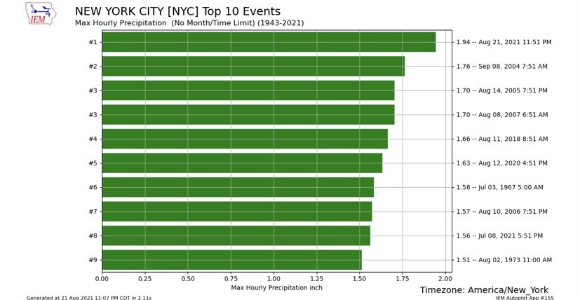
Central Park received 1.94” of rain in the last hour. That set a new hourly record. The old record was 1.76”, which was set on September 8, 2004.
- 1,603 replies
-
- 4
-
-
- hurricane gusts
- flooding rains
- (and 2 more)
-
For the first time, Central Park has had 2 consecutive hours with 1.35” or more of rain, as 1.60” has fallen so far during the current hour.
-
In the past hour, NYC’s Central Park received 1.38” of rain. This is the 3rd hourly figure of 1.35” or more this year. That breaks the #record of 2 such days, which had been set in 2006.
- 1,603 replies
-
- 2
-
-
- hurricane gusts
- flooding rains
- (and 2 more)