-
Posts
23,895 -
Joined
Content Type
Profiles
Blogs
Forums
American Weather
Media Demo
Store
Gallery
Everything posted by donsutherland1
-
Morning thoughts… Today will be partly to mostly sunny and much cooler. High temperatures will likely reach the upper 40s and lower 50s in most of the region. Likely high temperatures around the region include: New York City (Central Park): 47° Newark: 52° Philadelphia: 50° Normals: New York City: 30-Year: 52.8°; 15-Year: 52.9° Newark: 30-Year: 53.6°; 15-Year: 53.9° Philadelphia: 30-Year: 54.6°; 15-Year: 54.7° The weekend will start chilly but end mild.
-
Ahead of an advancing cold front, temperatures soared into the 60s and 70s across the region. High temperatures included: Albany: 65° Baltimore: 74° Boston: 70° Bridgeport: 64° Islip: 64° New York City: 69° Newark: 72° Philadelphia: 73° Poughkeepsie: 69° (tied record set in 1953 and 1963) Providence: 69° Washington, DC: 74° Wilmington, DE: 71° Newark reached 70° for the 177th time this year. The old record was 173 days, which was set in 2010. Four of the five years that saw 170 or more such days have occurred since 2000 and three have occurred since 2010. Noticeably colder air will return tomorrow. A generally dry and chilly weekend lies ahead. Another surge of cold air is possible early next week. Overall, it is likely that the temperature anomaly for the second half of November will be somewhat below normal due to the development of AO blocking. The latest teleconnections forecasts continue to suggest that the AO will drop sharply to somewhere between -3.000 and -1.000 on or after November 20. The duration of the blocking is uncertain. Such strong blocking typically favors a period of colder than normal weather (November 20-30, 1991-2020 period): Boston: Normal: 42.2°; AO cases: 38.4° New York City: Normal: 45.5°; AO cases: 41.7° Philadelphia: Normal: 45.4°; AO cases: 41.7° Fall 2021 is well on course to being wetter to much wetter than normal in the northern Middle Atlantic region. Since 1869, there have been 9 August cases where New York City picked up 20.00" or more rainfall during the summer. Two thirds of those cases (and 4/5 of those with summer mean temperatures of 73.0° or above) had 17.00" or more fall precipitation in New York City. 2011 is probably the closest match in terms of precipitation and a nearly identical summer mean temperature. Mean fall precipitation for those 9 cases was 14.86". The median was 17.35". The 1991-2020 normal value is 12.27". Fall rainfall through November 18 4 pm is 16.13". Following very wet July-September periods, winter (December-February) precipitation has typically been near or below normal. The most recent exception was winter 2018-19. The ENSO Region 1+2 anomaly was -0.7°C and the Region 3.4 anomaly was -0.8°C for the week centered around November 10. For the past six weeks, the ENSO Region 1+2 anomaly has averaged -0.53°C and the ENSO Region 3.4 anomaly has averaged -0.85°C. La Niña conditions will likely persist into at least late winter. The SOI was +17.69 today. The preliminary Arctic Oscillation (AO) figure was +0.617 today. On November 16 the MJO was in Phase 4 at an amplitude of 1.343 (RMM). The November 15-adjusted amplitude was 1.352 (RMM). Based on sensitivity analysis applied to the latest guidance, there is an implied 72% probability that New York City will have a cooler than normal November (1991-2020 normal). November will likely finish with a mean temperature near 47.2° (0.8° below normal).
-
Speaking of 80F temperatures, Phoenix has just recorded its November-record 18th consecutive 80F or above temperature. The previous record of 17 consecutive days was set during November 1-17, 1999.
-
As of 12:51 pm EST, Newark had recorded a daily high temperature of 70°. Today is Newark's 177th 70° or warmer day this year. The old record of 173 days was set in 2010.
-
There is an ongoing marine heatwave covering parts of the Pacific Ocean. That has increased the intensity of atmospheric rivers.
-
Morning thoughts… Today will be partly cloudy and unseasonably warm. High temperatures will likely reach the middle and upper 60s in most of the region. A few locations will reach 70°. Likely high temperatures around the region include: New York City (Central Park): 64° Newark: 69° Philadelphia: 70° Normals: New York City: 30-Year: 53.2°; 15-Year: 53.2° Newark: 30-Year: 54.0°; 15-Year: 54.2° Philadelphia: 30-Year: 55.0°; 15-Year: 55.0° A cold front will bring a period of rain overnight. Much cooler weather will follow.
-
Temperatures rose well into the 50s in the northern Mid-Atlantic region today. At Philadelphia, the mercury surged to 66°. Ahead of the next cold front, tomorrow will see this warmth overspread much of the region resulting in unseasonable warmth. This warmth will be short-lived. Noticeably colder air will return on Friday. Another surge of cold air is possible early next week. Overall, it is likely that the temperature anomaly for the second half of November will be somewhat below normal due to the development of AO blocking. The latest teleconnections forecasts suggest that the AO will drop sharply to somewhere between -3.000 and -1.000 on or after November 20. Such an outcome favors a period of colder than normal weather (November 20-30, 1991-2020 period): Boston: Normal: 42.2°; AO cases: 38.4° New York City: Normal: 45.5°; AO cases: 41.7° Philadelphia: Normal: 45.4°; AO cases: 41.7° Fall 2021 is well on course to being wetter to much wetter than normal in the northern Middle Atlantic region. Since 1869, there have been 9 August cases where New York City picked up 20.00" or more rainfall during the summer. Two thirds of those cases (and 4/5 of those with summer mean temperatures of 73.0° or above) had 17.00" or more fall precipitation in New York City. 2011 is probably the closest match in terms of precipitation and a nearly identical summer mean temperature. Mean fall precipitation for those 9 cases was 14.86". The median was 17.35". The 1991-2020 normal value is 12.27". Fall rainfall through November 16 4 pm is 16.13". Following very wet July-September periods, winter (December-February) precipitation has typically been near or below normal. The most recent exception was winter 2018-19. The ENSO Region 1+2 anomaly was -0.7°C and the Region 3.4 anomaly was -0.8°C for the week centered around November 10. For the past six weeks, the ENSO Region 1+2 anomaly has averaged -0.53°C and the ENSO Region 3.4 anomaly has averaged -0.85°C. La Niña conditions will likely persist into at least late winter. The SOI was +14.44 today. The preliminary Arctic Oscillation (AO) figure was +0.343 today. On November 15 the MJO was in Phase 4 at an amplitude of 1.341 (RMM). The November 14-adjusted amplitude was 1.391 (RMM). Based on sensitivity analysis applied to the latest guidance, there is an implied 67% probability that New York City will have a cooler than normal November (1991-2020 normal). November will likely finish with a mean temperature near 47.3° (0.7° below normal).
-
Morning thoughts… Today will be partly to mostly sunny and milder. High temperatures will likely reach the middle and upper 50s in most of the region. A few locations will reach the lower 60s. Likely high temperatures around the region include: New York City (Central Park): 56° Newark: 59° Philadelphia: 62° Normals: New York City: 30-Year: 53.2°; 15-Year: 53.6° Newark: 30-Year: 54.4°; 15-Year: 54.6° Philadelphia: 30-Year: 55.3°; 15-Year: 55.4° Ahead of the next cold front, tomorrow will be unseasonably warm.
-
Warmer air will move back into the region tomorrow. Ahead of the next cold front, Thursday will see much above normal temperatures. Noticeably colder air will return on Friday. Another surge is possible early next week. Overall, it is likely that the temperature anomaly for the second half of November will be somewhat below normal due to the development of AO blocking. The latest teleconnections forecasts suggest that the AO will drop sharply to somewhere between -3.000 and -1.000 on or after November 20. Such an outcome favors a period of colder than normal weather (November 20-30, 1991-2020 period): Boston: Normal: 42.2°; AO cases: 38.4° New York City: Normal: 45.5°; AO cases: 41.7° Philadelphia: Normal: 45.4°; AO cases: 41.7° Fall 2021 is well on course to being wetter to much wetter than normal in the northern Middle Atlantic region. Since 1869, there have been 9 August cases where New York City picked up 20.00" or more rainfall during the summer. Two thirds of those cases (and 4/5 of those with summer mean temperatures of 73.0° or above) had 17.00" or more fall precipitation in New York City. 2011 is probably the closest match in terms of precipitation and a nearly identical summer mean temperature. Mean fall precipitation for those 9 cases was 14.86". The median was 17.35". The 1991-2020 normal value is 12.27". Fall rainfall through November 16 4 pm is 16.13". Following very wet July-September periods, winter (December-February) precipitation has typically been near or below normal. The most recent exception was winter 2018-19. The ENSO Region 1+2 anomaly was -0.7°C and the Region 3.4 anomaly was -0.8°C for the week centered around November 10. For the past six weeks, the ENSO Region 1+2 anomaly has averaged -0.53°C and the ENSO Region 3.4 anomaly has averaged -0.85°C. La Niña conditions will likely persist into at least late winter. The SOI was +2.03 today. The preliminary Arctic Oscillation (AO) figure was +0.928 today. On November 14 the MJO was in Phase 5 at an amplitude of 1.388 (RMM). The November 13-adjusted amplitude was 1.189 (RMM). Based on sensitivity analysis applied to the latest guidance, there is an implied 66% probability that New York City will have a cooler than normal November (1991-2020 normal). November will likely finish with a mean temperature near 47.4° (0.6° below normal).
-
Morning thoughts… Today will be partly to mostly sunny but still cool. High temperatures will likely reach the upper 40s and lower 50s in most of the region. Likely high temperatures around the region include: New York City (Central Park): 48° Newark: 52° Philadelphia: 50° Normals: New York City: 30-Year: 53.9°; 15-Year: 53.9° Newark: 30-Year: 54.7°; 15-Year: 54.9° Philadelphia: 30-Year: 55.7°; 15-Year: 55.7° Warmer air will arrive tomorrow.
-
Tomorrow will be another unseasonably cool day. Warmer air will move back into the region on Wednesday. Ahead of the next cold front, Thursday will see much above normal temperatures. Overall, it is now more likely than not that the temperature anomaly for the second half of November will be near or somewhat below normal. The latest teleconnections forecasts suggest that the AO will drop sharply to somewhere between -3.000 and -1.000 on or after November 20. Such an outcome favors a period of colder than normal weather (November 20-30, 1991-2020 period): Boston: Normal: 42.2°; AO cases: 38.4° New York City: Normal: 45.5°; AO cases: 41.7° Philadelphia: Normal: 45.4°; AO cases: 41.7° Fall 2021 is well on course to being wetter to much wetter than normal in the northern Middle Atlantic region. Since 1869, there have been 9 August cases where New York City picked up 20.00" or more rainfall during the summer. Two thirds of those cases (and 4/5 of those with summer mean temperatures of 73.0° or above) had 17.00" or more fall precipitation in New York City. 2011 is probably the closest match in terms of precipitation and a nearly identical summer mean temperature. Mean fall precipitation for those 9 cases was 14.86". The median was 17.35". The 1991-2020 normal value is 12.27". Fall rainfall through November 15 4 pm is 16.13". Following very wet July-September periods, winter (December-February) precipitation has typically been near or below normal. The most recent exception was winter 2018-19. The ENSO Region 1+2 anomaly was -0.7°C and the Region 3.4 anomaly was -0.8°C for the week centered around November 10. For the past six weeks, the ENSO Region 1+2 anomaly has averaged -0.53°C and the ENSO Region 3.4 anomaly has averaged -0.85°C. La Niña conditions will likely persist into at least late winter. The SOI was -6.81 today. The preliminary Arctic Oscillation (AO) figure was +0.917 today. On November 13 the MJO was in Phase 5 at an amplitude of 1.187 (RMM). The November 12-adjusted amplitude was 1.107 (RMM). Based on sensitivity analysis applied to the latest guidance, there is an implied 64% probability that New York City will have a cooler than normal November (1991-2020 normal). November will likely finish with a mean temperature near 47.5° (0.5° below normal).
-
Morning thoughts… Today will be partly to mostly sunny but unseasonably cool. High temperatures will likely reach the upper 40s and lower 50s in most of the region. Likely high temperatures around the region include: New York City (Central Park): 47° Newark: 51° Philadelphia: 51° Normals: New York City: 30-Year: 54.2°; 15-Year: 54.2° Newark: 30-Year: 55.1°; 15-Year: 55.3° Philadelphia: 30-Year: 56.1°; 15-Year: 56.1° Warmer air will arrive on Wednesday.
-
Tomorrow will be another unseasonably cool day. Much of the region will again see temperatures rise no higher than the middle and upper 40s. The cool weather will likely continue until midweek. Overall, there remains uncertainty about the temperature anomaly for the second half of November. However, the latest teleconnections forecasts now suggest that the AO will drop sharply to somewhere between -3.000 and -1.000 on or after November 20. Such an outcome favors a period of colder than normal weather (November 20-30, 1991-2020 period): Boston: Normal: 42.2°; AO cases: 38.4° New York City: Normal: 45.5°; AO cases: 41.7° Philadelphia: Normal: 45.4°; AO cases: 41.7° Fall 2021 is well on course to being wetter to much wetter than normal in the northern Middle Atlantic region. Since 1869, there have been 9 August cases where New York City picked up 20.00" or more rainfall during the summer. Two thirds of those cases (and 4/5 of those with summer mean temperatures of 73.0° or above) had 17.00" or more fall precipitation in New York City. 2011 is probably the closest match in terms of precipitation and a nearly identical summer mean temperature. Mean fall precipitation for those 9 cases was 14.86". The median was 17.35". The 1991-2020 normal value is 12.27". Fall rainfall through November 14 4 pm is 16.11". Following very wet July-September periods, winter (December-February) precipitation has typically been near or below normal. The most recent exception was winter 2018-19. The ENSO Region 1+2 anomaly was -0.8°C and the Region 3.4 anomaly was -1.0°C for the week centered around November 3. For the past six weeks, the ENSO Region 1+2 anomaly has averaged -0.27°C and the ENSO Region 3.4 anomaly has averaged -0.78°C. La Niña conditions will likely persist into at least late winter. The SOI was +7.12 today. The preliminary Arctic Oscillation (AO) figure was +0.428 today. On November 12 the MJO was in Phase 5 at an amplitude of 1.104 (RMM). The November 11-adjusted amplitude was 1.135 (RMM). Based on sensitivity analysis applied to the latest guidance, there is an implied 56% probability that New York City will have a cooler than normal November (1991-2020 normal). November will likely finish with a mean temperature near 47.7° (0.3° below normal).
-
A forecast will bust—either calls for a cold winter or nature’s seemingly warm outlook: Viburnum Witch Hazel Lilac
-
Morning thoughts… Today will be variably cloudy and unseasonably cool. High temperatures will likely reach the middle and upper 40s in most of the region. Likely high temperatures around the region include: New York City (Central Park): 46° Newark: 50° Philadelphia: 48° Normals: New York City: 30-Year: 54.5°; 15-Year: 54.6° Newark: 30-Year: 55.5°; 15-Year: 55.7° Philadelphia: 30-Year: 56.4°; 15-Year: 56.4° Unseasonably cool weather will continue until midweek.
-
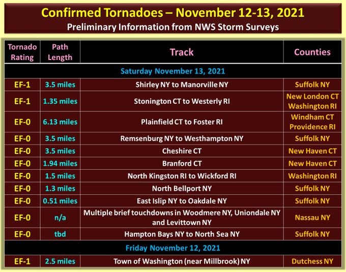
Mild and tranquil conditions came to a crashing end as violent thunderstorms with high winds, hail, and heavy downpours moved rapidly across the region. Tornadoes inflicted damage in parts of Long Island. In the wake of the responsible frontal passage, temperatures plummeted into the lower and middle 40s. Tomorrow will be an unseasonably cool day. Much of the region will see temperatures rise no higher than the middle and upper 40s. The cool weather will likely continue until midweek. Overall, there remains uncertainty about the temperature anomaly for the second half of November. With the MJO oscillating between Phases 3 and 4 over the past week, there is little signal for a change from the current back-and-forth pattern. The CFSv2 actually shows a strong warmup during and beyond week 1, but it is currently a warm outlier. However, the risk of that scenario cannot be written off altogether. Fall 2021 is well on course to being wetter to much wetter than normal in the northern Middle Atlantic region. Since 1869, there have been 9 August cases where New York City picked up 20.00" or more rainfall during the summer. Two thirds of those cases (and 4/5 of those with summer mean temperatures of 73.0° or above) had 17.00" or more fall precipitation in New York City. 2011 is probably the closest match in terms of precipitation and a nearly identical summer mean temperature. Mean fall precipitation for those 9 cases was 14.86". The median was 17.35". The 1991-2020 normal value is 12.27". Fall rainfall through November 13 4 pm is 16.11". Following very wet July-September periods, winter (December-February) precipitation has typically been near or below normal. The most recent exception was winter 2018-19. The ENSO Region 1+2 anomaly was -0.8°C and the Region 3.4 anomaly was -1.0°C for the week centered around November 3. For the past six weeks, the ENSO Region 1+2 anomaly has averaged -0.27°C and the ENSO Region 3.4 anomaly has averaged -0.78°C. La Niña conditions will likely persist into at least late winter. The SOI was +13.55 today. The preliminary Arctic Oscillation (AO) figure was -0.195 today. On November 11 the MJO was in Phase 4 at an amplitude of 1.132 (RMM). The November 10-adjusted amplitude was 1.071 (RMM). Based on sensitivity analysis applied to the latest guidance, there is an implied 52% probability that New York City will have a cooler than normal November (1991-2020 normal). November will likely finish with a mean temperature near 47.7° (0.3° below normal).


