donsutherland1
-
Posts
23,768 -
Joined
Content Type
Profiles
Blogs
Forums
American Weather
Media Demo
Store
Gallery
Everything posted by donsutherland1
-
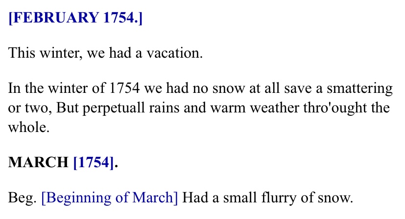
Of course, there were some bleak winters during the 18th century, too. From John Adams’ diary:
-
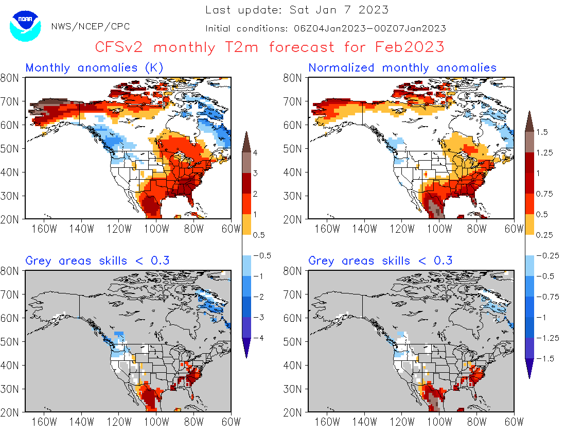
The actual CFSv2 forecast is for a warmer than normal February. Of course, at this range, skill is very low.

-
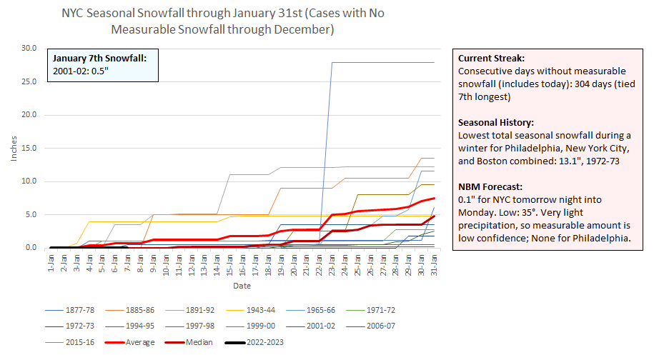
2001-02 received 0.5” of snow on today’s date.
-
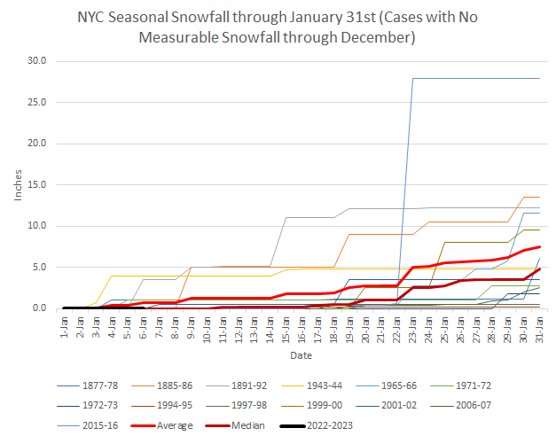
Today, Winter 2022-2023 will become just the 9th winter on record during which New York City had seen no measurable snowfall through January 7th. The last such winter was 2015-2016. Those winters were: 1885-1886, 1965-1966, 1972-1973, 1994-1995, 1997-1998, 1999-2000, 2006-2007, 2015-2016, and 2022-2023.
-
No. Boston had 0.2” yesterday bringing the seasonal total to 1.2”.
-
The smoothing can result in large differences between what fell at a specific location and the average figure for a geographic area.
-
This is an early report. I suspect it will be revised lower later this year.
-
There are a variety of solutions. The absence of sufficient cold will be the biggest problem.
-
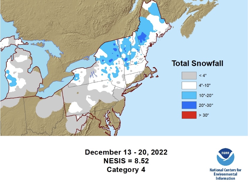
From the site: “The aerial distribution of snowfall and population information are combined in an equation that calculates a NESIS score…” The score may yet be adjusted.
-
Prospects for a January 13-15 snowfall--never more than a low probability for a big snowfall, but a moderate probability for measurable snowfall in the NYC area for a time--are diminishing.
-
Morning thoughts… It will be partly sunny and mild. High temperatures will reach the middle and upper 40s in most areas. Likely high temperatures around the region include: New York City (Central Park): 46° Newark: 48° Philadelphia: 48° After a dry weekend, a weak system could bring some rain or wet snow to the region Sunday night into Monday. Normals: New York City: 30-Year: 39.7°; 15-Year: 40.7° Newark: 30-Year: 40.2°; 15-Year: 41.4° Philadelphia: 30-Year: 41.6°; 15-Year: 42.5°
-
Here’s the list. https://www.ncei.noaa.gov/access/monitoring/rsi/nesis
-
That was another awesome blizzard. That the models suddenly trended from an offshore solution to a blockbuster storm made it even more memorable.
-
It was an incredible and unforgettable blizzard. I was in the Washington area at the time and it was amazing how it shut down the entire area.
-
Some photos from the Blizzard of 1996. https://www.digitalsnowmuseum.org/photo1996x.html For now, the only snow we have is in our memories or the virtual kind on models.
-
The second warmest opening week of January is nearing an end with a slow cooling trend underway. That cooling trend will continue through the weekend. The second week of January will be cooler, but a cold outcome is unlikely. Some guidance suggests that there could be a sharper but brief cold shot just before mid-month. However, once moderate support for snowfall during the January 13-15 period has been declining. Just 18% of 12z EPS members now show 1" or more snow for New York City. Prior to then, there is a low probability of measurable snowfall Sunday night into Monday. 2022 became the 14th year during which New York City received no measurable snowfall through December 31st. During the 13 prior years, mean seasonal snowfall was 16.0" (median seasonal snowfall: 16.3"). Just 8% of those winters rallied to see 30" or more seasonal snowfall. 31% of those winters wound up with less than 10" of seasonal snowfall. Just under half (46%) had 20" or more seasonal snowfall. The lowest seasonal snowfall for those cases of 2.8" was recorded in 1972-1973. The highest seasonal snowfall for those cases was 32.8", which occurred during 2015-2016. The ENSO Region 1+2 anomaly was -0.3°C and the Region 3.4 anomaly was -0.7°C for the week centered around December 28. For the past six weeks, the ENSO Region 1+2 anomaly has averaged -0.48°C and the ENSO Region 3.4 anomaly has averaged -0.87°C. La Niña conditions will likely persist through mid-winter before fading to neutral conditions. The SOI was +17.44 today. The preliminary Arctic Oscillation (AO) was -1.814 today. On January 4 the MJO was in Phase 7 at an amplitude of 1.099 (RMM). The January 3-adjusted amplitude was 1.353 (RMM).
-
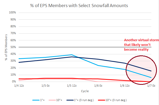
The once moderate potential for measurable snow during the January 13-15 period has continued to decline on the EPS ensembles.
-
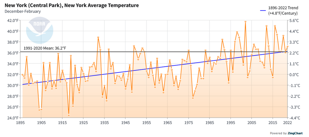
Years and winters have been warming in the New York City area. Winter trends are below:
-
Yes, that’s Celsius.
-
Some low snowfall winters here have had big Southeast or Lower Mid-Atlantic snowstorms. Examples include 1972-73, 1979-80, and 2001-02 (as you referenced above).
-
Offshore may be more likely.
-
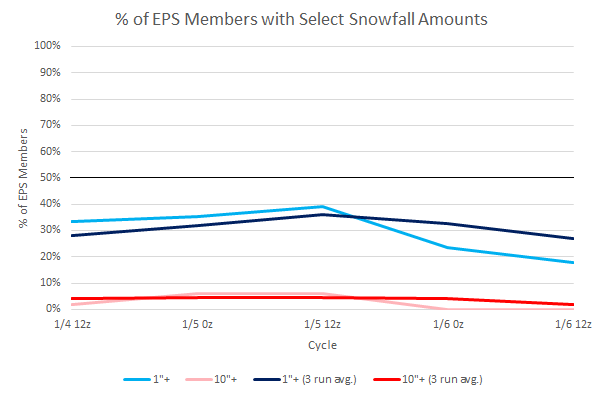
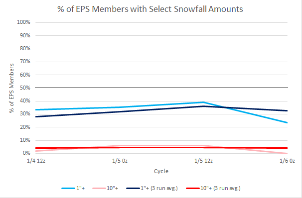
Overnight, not much has changed from my initial thinking concerning the potential January 13-15 snowfall. The overall pattern is not consistent with those that have seen big snowfalls based on the forecast teleconnections. There remains a moderate probability that New York City will see a measurable snowfall. The probability of a large (10" or more) snowfall remains very low. Given the timeframe involved, things can change. Below is recent data from the EPS ensembles for New York City:
-
Morning thoughts… Light rain will end. Clouds could break during the afternoon. High temperatures will reach the upper 40s and lower 50s in most areas. Likely high temperatures around the region include: New York City (Central Park): 47° Newark: 50° Philadelphia: 50° A dry weekend lies ahead. Normals: New York City: 30-Year: 39.9°; 15-Year: 40.8° Newark: 30-Year: 40.3°; 15-Year: 41.5° Philadelphia: 30-Year: 41.7°; 15-Year: 42.7°
-
Yes. That’s a big part of it. That happened in 2001-02, as well.
-
Tonight and tomorrow will see some showers. Readings will be mainly in the 40s. The slow cooling trend will continue through the weekend. Nevertheless. daily temperatures will continue to run warmer than normal through the first 10 days of January. Overall, readings will average about 15° above normal during the first week of the month. The second week of January will see some cooling from the first week's exceptional warmth, but a cold outcome is unlikely. Some guidance suggests that there could be a sharper but brief cold shot just before mid-month. There is moderate ensemble support for snowfall during the January 13-15 period with 39% of 12z EPS members showing 1" or more snow. 2022 became the 14th year during which New York City received no measurable snowfall through December 31st. During the 13 prior years, mean seasonal snowfall was 16.0" (median seasonal snowfall: 16.3"). Just 8% of those winters rallied to see 30" or more seasonal snowfall. 31% of those winters wound up with less than 10" of seasonal snowfall. Just under half (46%) had 20" or more seasonal snowfall. The lowest seasonal snowfall for those cases of 2.8" was recorded in 1972-1973. The highest seasonal snowfall for those cases was 32.8", which occurred during 2015-2016. The ENSO Region 1+2 anomaly was -0.3°C and the Region 3.4 anomaly was -0.7°C for the week centered around December 28. For the past six weeks, the ENSO Region 1+2 anomaly has averaged -0.48°C and the ENSO Region 3.4 anomaly has averaged -0.87°C. La Niña conditions will likely persist through mid-winter before fading to neutral conditions. The SOI was +13.43 today. The preliminary Arctic Oscillation (AO) was -1.632 today. On January 2 the MJO was in Phase 7 at an amplitude of 1.241 (RMM). The January 1-adjusted amplitude was 1.369 (RMM).