

donsutherland1
-
Posts
23,767 -
Joined
Content Type
Profiles
Blogs
Forums
American Weather
Media Demo
Store
Gallery
Everything posted by donsutherland1
-
Morning thoughts… Clouds will increase during the day. A soaking rain will arrive late in the day or at night and continue into tomorrow. A general 0.50”-1.50” of rain is likely. High temperatures will reach the lower and middle 40s in most of the region. Likely high temperatures around the region include: New York City (Central Park): 44° Newark: 47° Philadelphia: 49° It will turn milder on Sunday. Normals: New York City: 30-Year: 45.8°; 15-Year: 46.5° Newark: 30-Year: 47.1°; 15-Year: 47.7° Philadelphia: 30-Year: 48.7°; 15-Year: 48.9°
-
LGA's record is 77.9" during winter 1995-96.
-
The ranking includes both components. It’s close. I’ll have to check later.
-
We’re currently #2 just behind 2001-02.
-
A storm will bring rain to Philadelphia, Newark, and New York City tomorrow into Saturday. Some frozen precipitation is possible well to the north and west of the cities. A moderate to significant snowfall is likely across central New York State and central to northern New England. Albany could see 5"-10" of snow. After what increasingly appears to be a warmer than normal first week to March, a colder regime could develop during the second week of the month. At present, no severe March cold appears likely. The colder regime could last into or even through the closing week of March. In addition, historic experience with very low snowfall totals through February argues that a very snowy March or big snowstorm during March or April are unlikely. Despite attractive 500 mb patterns, the base case is that at least through March 10th, snowfall will likely be below normal from Philadelphia to New York City. Reflecting the base case scenario, the 12z operational ECMWF, GFS, and GGEM have no significant snowfall through March 10th. The ENSO Region 1+2 anomaly was +0.4°C and the Region 3.4 anomaly was -0.3°C for the week centered around February 22. For the past six weeks, the ENSO Region 1+2 anomaly has averaged +0.25°C and the ENSO Region 3.4 anomaly has averaged -0.50°C. La Niña conditions fading and they should evolve to neutral conditions during late winter or early spring. The SOI was +12.16 today. The preliminary Arctic Oscillation (AO) was +1.099 today. On February 28 the MJO was in Phase 7 at an amplitude of 1.253 (RMM). The February 27-adjusted amplitude was 0.982 (RMM).
-
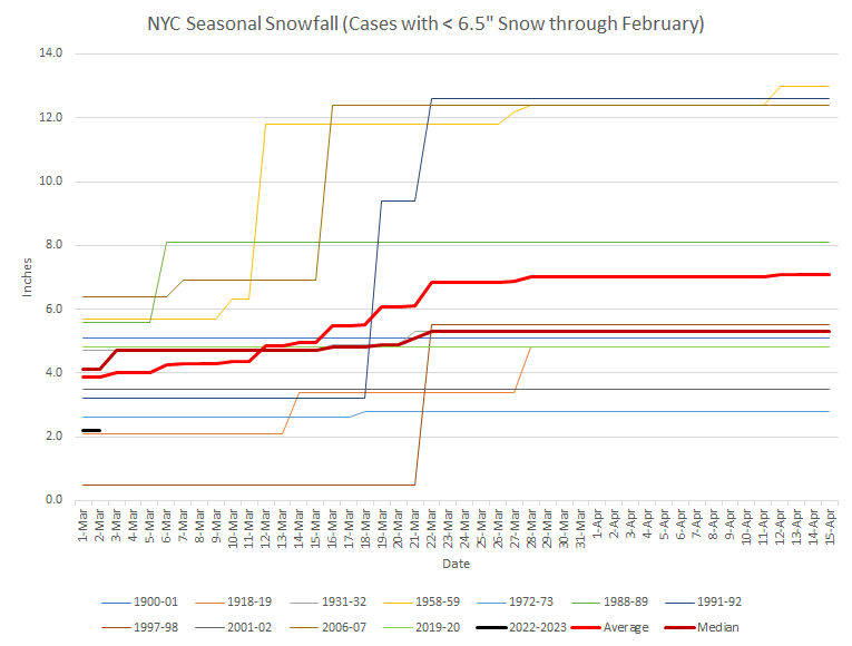
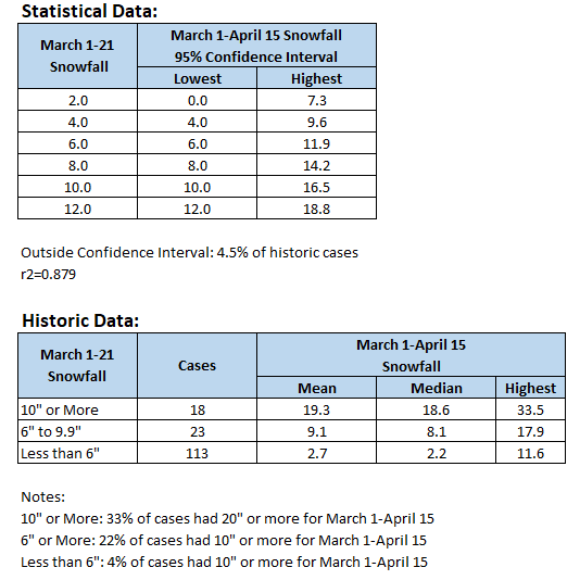
Lowest snow seasons through February and their progression through April 15th. Mean additional snowfall: 3.2". Maximum in the sample: 9.4". Possible insight: Prospects for a very snowy March or a big March snowstorm are probably low, if the historic experience is representative.
-
Tomorrow will be unseasonably mild. Temperatures will likely surge well into the 50s ahead of a cold front. Showers are possible. Another storm is possible later Friday into Saturday. From Philadelphia to New York City, the storm will likely be mostly or all rain. Some frozen precipitation is possible well to the north and west of the cities. After a somewhat warmer than normal start, a colder regime will likely develop during the second week of the month and could last into the closing week of March. Overall, March will likely wind up colder than normal. The ENSO Region 1+2 anomaly was +0.4°C and the Region 3.4 anomaly was -0.3°C for the week centered around February 22. For the past six weeks, the ENSO Region 1+2 anomaly has averaged +0.25°C and the ENSO Region 3.4 anomaly has averaged -0.50°C. La Niña conditions fading and they should evolve to neutral conditions during late winter or early spring. The SOI was +6.84 today. The preliminary Arctic Oscillation (AO) was +0.460 today. On February 27 the MJO was in Phase 7 at an amplitude of 0.980 (RMM). The February 26-adjusted amplitude was 0.729 (RMM).
-
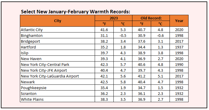
New Haven was the only location to set a new record for meteorological winter: 38.9° (old record: 37.5°, 2011-2012). Newark tied its mark from 2001-2002 with a mean temperature of 41.1°.
-
Given the extreme forecast made concerning New York City's March 1-April 15 snowfall, a look at what will likely be needed to get there is in order. Approximately 77% of New York City's March 1-April 15 snowfall occurs during March 1-21. All cases with 20" or more such snowfall had 10" or more during March 1-21.
-
Much of the region experienced its warmest January-February on record. Moreover, had it not been for the short-lived December 23-26 Arctic blast, New York City would have had its warmest winter on record.
-
Morning thoughts… Today will be partly cloudy and seasonably cool. High temperatures will reach the lower and middle 40s in most of the region. Southern New Jersey and southeastern Pennsylvania will see readings top out in the upper 40s and lower 50s. Likely high temperatures around the region include: New York City (Central Park): 44° Newark: 46° Philadelphia: 52° Tomorrow will be unseasonably mild with some showers. Normals: New York City: 30-Year: 45.3°; 15-Year: 45.6° Newark: 30-Year: 46.3°; 15-Year: 46.8° Philadelphia: 30-Year: 47.9°; 15-Year: 47.9°
-
In the wake of New York City's biggest snowstorm of the winter, temperatures remained in the 30s throughout the day. As a result, February concluded with a mean temperature of 41.1°, which was 5.2° above normal. That was warm enough to rank as the City's 3rd warmest February on record. All of the top 3 have occurred since 2017. All of the top 5 have occurred since 2002. It will turn milder tomorrow. Thursday will be unseasonably mild. Temperatures will likely surge well into the 50s ahead of a cold front. Another storm is possible later Friday into Saturday. From Philadelphia to New York City, the storm will likely be mostly or all rain. Some frozen precipitation is possible well to the north and west of the cities. After a somewhat warmer than normal start, a colder regime will likely develop and could last into the closing week of March. Overall, March will likely wind up colder than normal. The ENSO Region 1+2 anomaly was +0.4°C and the Region 3.4 anomaly was -0.3°C for the week centered around February 22. For the past six weeks, the ENSO Region 1+2 anomaly has averaged +0.25°C and the ENSO Region 3.4 anomaly has averaged -0.50°C. La Niña conditions fading and they should evolve to neutral conditions during late winter or early spring. The SOI was +6.58 today. The preliminary Arctic Oscillation (AO) was +1.363 today. On February 25 the MJO was in Phase 7 at an amplitude of 0.771 (RMM). The February 24-adjusted amplitude was 0.792 (RMM).
-
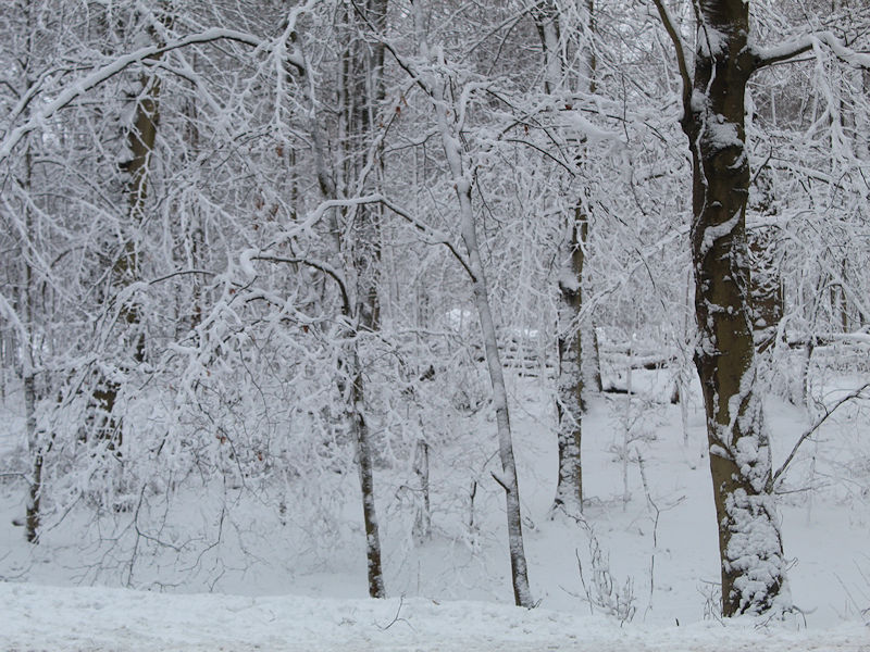
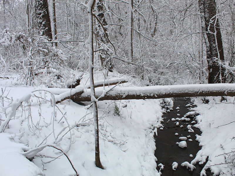
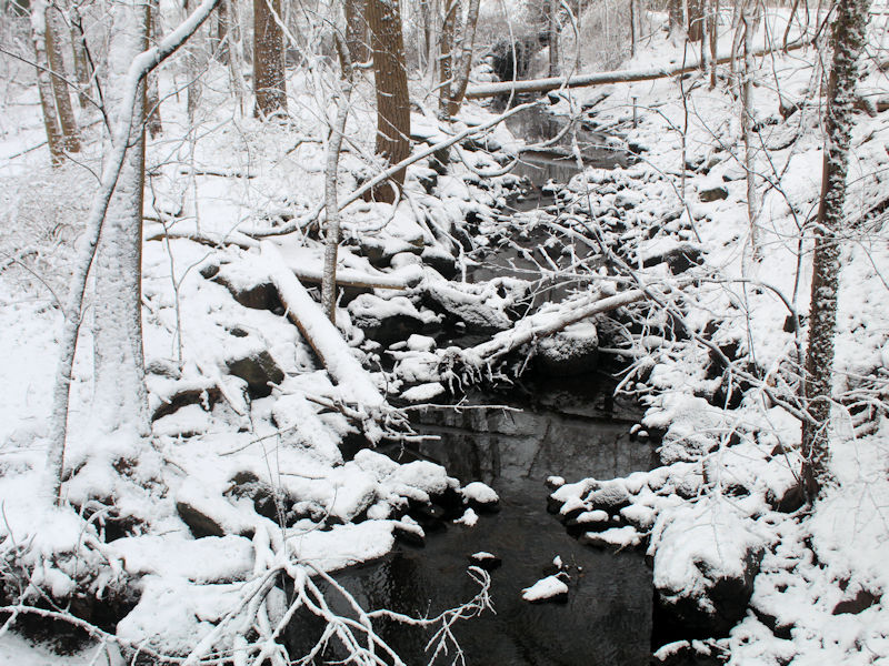
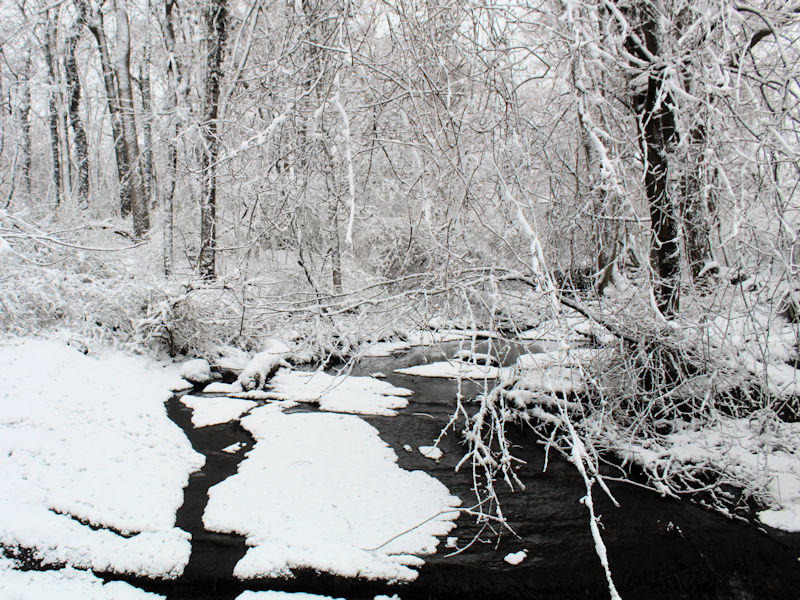
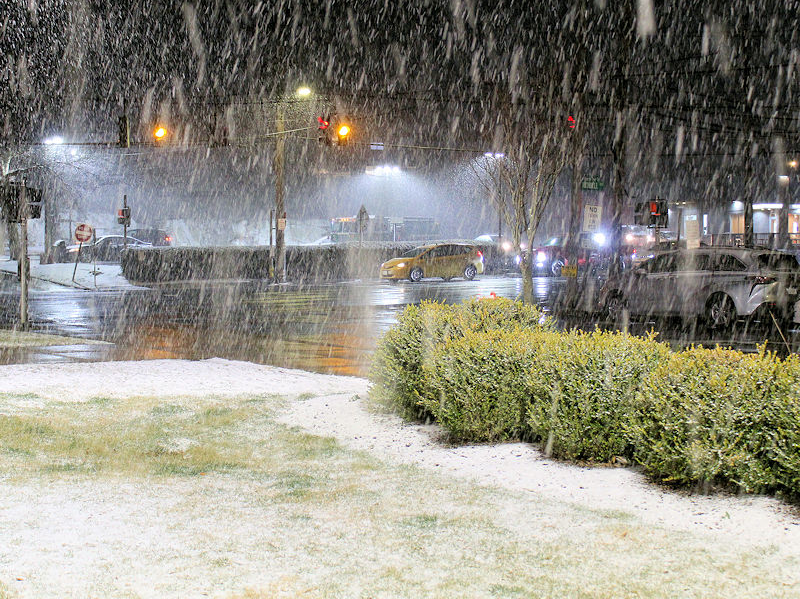
Some photos from the snowfall:
-
That includes through April 15.
-
Periodic update on the extreme forecast for NYC for 3/1-4/15: 5° below normal; 20" snow. https://www.americanwx.com/bb/topic/58486-winter-banter-thread/?do=findComment&comment=6823796 Based on the latest guidance, the first 10 days of March will average around 1° below normal. For the overall 3/1-5/15 period to average 5° below normal, the remainder of the period would need to average 6.1° below normal. The 1991-2020 normal temperature for 3/11-4/15 is 46.9°. That means the period would need to have a mean temperature of 40.8° or below for the extreme forecast to verify. The last time that happened was in 1956. Future updates will be based on actual data.
-
March 2023 temperature forecast contest
donsutherland1 replied to Roger Smith's topic in Weather Forecasting and Discussion
DCA _ NYC _ BOS __ ORD _ ATL _ IAH ___ DEN _ PHX _ SEA -0.4 -1.8 -1.7 -0.3 2.5 1.0 -1.2 -2.6 -3.6 -
They probably had 4"-5". I drove by there this morning.
-
Many 3"-6" amounts were reported just outside NYC (also including the Bronx).
-
EWR: 1.7" JFK: 1.5" LGA: 2.7" NYC: 1.8"
-
JFK had 1.0” yesterday. That broke the daily record of 0.4” from 1979 and 1991.
-
Snow falling at Mamaroneck, New York:
-
A storm will bring New York City and Newark 1"-3" of snow before the precipitation changes to rain overnight. Immediately north and west of the City, 2"-4" is likely. In the far northern and western suburbs, 3"-6" of snow is likely. The precipitation will end tomorrow. It will remain cool. Wednesday and especially Thursday will be milder. Temperatures will likely surge well into the 50s on Thursday ahead of a cold front. Another storm is possible later Friday into Saturday. The guidance has grown milder for the first week of March. The EPS now suggests readings could wind up somewhat above normal. The latest ECMWF weekly forecast suggests that the second week of March could transition toward a colder regime that could last into the closing week of March. The ENSO Region 1+2 anomaly was +0.8°C and the Region 3.4 anomaly was -0.5°C for the week centered around February 15. For the past six weeks, the ENSO Region 1+2 anomaly has averaged +0.15°C and the ENSO Region 3.4 anomaly has averaged -0.56°C. La Niña conditions fading and they should evolve to neutral conditions during late winter or early spring. The SOI was not available today. The preliminary Arctic Oscillation (AO) was +1.363 today. MJO data was unavailable. Based on sensitivity analysis applied to the latest guidance, there is an implied near 100% probability that New York City will have a warmer than normal February (1991-2020 normal). February will likely finish with a mean temperature near 41.2° (5.3° above normal).
-
Could happen, especially if the changeover doesn't occur near midnight or the snow is on the heavier side of the guidance (e.g., 12z GFS amounts).
-
Yes.
-
NW NJ and areas north of White Plains—maybe even White Plains—will likely be closed.

