donsutherland1
-
Posts
23,765 -
Joined
Content Type
Profiles
Blogs
Forums
American Weather
Media Demo
Store
Gallery
Everything posted by donsutherland1
-
-
Record high minimum temperatures will be set today in Bridgeport, Islip, New Haven, New York City (Central Park, JFK, LGA), Newark, and White Plains.
-
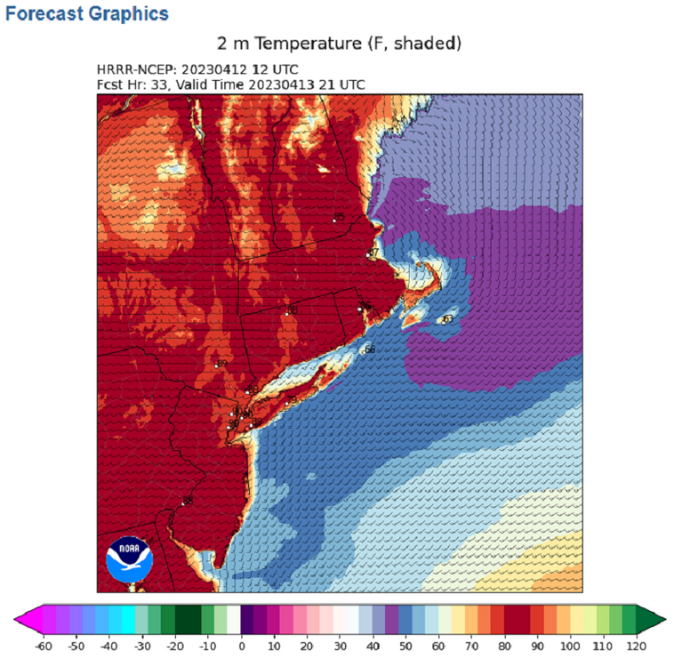
Temperatures rose into the middle and upper 60s today. Even warmer weather lies ahead. From the Southwest to Northern Plains, exceptional heat prevailed. High temperatures included: Cheyenne: 80° (old record: 73°, 1982 and 1998) Denver: 85° (old record: 80°, 1982) Phoenix: 99° (old record: 98°, 1989) Rapid City: 87° (old record: 85°, 1985) Salt Lake City: 83° (old record: 80°, 1934) Scotts Bluff, NE: 92° (old record: 85°, 1916 and 1985) Tucson: 99° (old record: 95°, 1907, 1988, and 2018) Some of this warmth will spill over into the East to end the week. Temperatures could reach the middle 80s by late in the week, possibly challenging or breaking some record highs on Friday. Overall, warmth appears likely to define April in much of the East. If the long-range guidance is accurate the first three weeks of the month could put April 2023 on a trajectory that could rank it among the 10 warmest Aprils on record in the northern Middle Atlantic region. Afterward, the latest EPS weeklies suggest that the month could finish with near normal readings. The most recent April case to rank among the 10 warmest was: Boston: 51.7°, 2019 (5th warmest) Bridgeport: 54.0°, 2017 (1st warmest) Islip: 51.9°, 2019 (6th warmest) New Haven: 50.8°, 2022 (6th warmest) New York City-Central Park: 57.2°, 2017 (2nd warmest) New York City-JFK Airport: 55.1°, 2017 (2nd warmest) New York City-LaGuardia Airport: 57.6°, 2017 (2nd warmest) Newark: 57.2°, 2017 (4th warmest) Philadelphia: 59.0°, 2019 (3rd warmest) Poughkeepsie: 53.0°, 2017 (3rd warmest) White Plains: 53.9°, 2017 (2nd warmest) The ENSO Region 1+2 anomaly was +2.7°C and the Region 3.4 anomaly was 0.0°C for the week centered around April 5. For the past six weeks, the ENSO Region 1+2 anomaly has averaged +1.77°C and the ENSO Region 3.4 anomaly has averaged -0.03°C. Neutral ENSO conditions will likely prevail through at least mid-spring. El Niño conditions will likely develop during the summer. The SOI was +0.43 today. The preliminary Arctic Oscillation (AO) was +1.473 today. On April 9 the MJO was in Phase 6 at an amplitude of 1.717 (RMM). The April 8-adjusted amplitude was 1.477 (RMM). Based on sensitivity analysis applied to the latest guidance, there is an implied 89% probability that New York City will have a warmer than normal April (1991-2020 normal). April will likely finish with a mean temperature near 57.4° (3.7° above normal). That would rank as the second warmest April on record.
-
Cheyenne also recorded its earliest 80-degree reading on record.
-
Temperatures rose into the middle and upper 60s today. Even warmer weather lies ahead. In coming days, the calendar will seemingly be turned ahead closer to summer, as an impressive warmup evolves. Temperatures could reach the middle 80s by late in the week, possibly challenging or breaking some record highs on Friday. Overall, warmth appears likely to define April in much of the East. If the long-range guidance is accurate the first three weeks of the month could put April 2023 on a trajectory that could rank it among the 10 warmest Aprils on record in the northern Middle Atlantic region. Afterward, the latest EPS weeklies suggest that the month could finish with near normal readings. The most recent April case to rank among the 10 warmest was: Boston: 51.7°, 2019 (5th warmest) Bridgeport: 54.0°, 2017 (1st warmest) Islip: 51.9°, 2019 (6th warmest) New Haven: 50.8°, 2022 (6th warmest) New York City-Central Park: 57.2°, 2017 (2nd warmest) New York City-JFK Airport: 55.1°, 2017 (2nd warmest) New York City-LaGuardia Airport: 57.6°, 2017 (2nd warmest) Newark: 57.2°, 2017 (4th warmest) Philadelphia: 59.0°, 2019 (3rd warmest) Poughkeepsie: 53.0°, 2017 (3rd warmest) White Plains: 53.9°, 2017 (2nd warmest) The ENSO Region 1+2 anomaly was +2.7°C and the Region 3.4 anomaly was 0.0°C for the week centered around April 5. For the past six weeks, the ENSO Region 1+2 anomaly has averaged +1.77°C and the ENSO Region 3.4 anomaly has averaged -0.03°C. Neutral ENSO conditions will likely prevail through at least mid-spring. El Niño conditions will likely develop during the summer. The SOI was +5.55 today. The preliminary Arctic Oscillation (AO) was +1.066 today. On April 8 the MJO was in Phase 6 at an amplitude of 1.470 (RMM). The April 7-adjusted amplitude was 1.205 (RMM). Based on sensitivity analysis applied to the latest guidance, there is an implied 87% probability that New York City will have a warmer than normal April (1991-2020 normal). April will likely finish with a mean temperature near 57.3° (3.6° above normal). That would rank as the second warmest April on record.
-
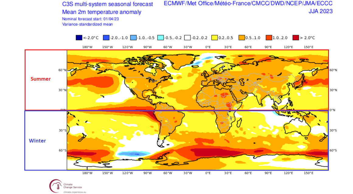
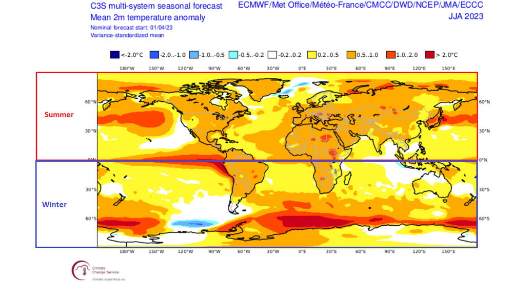
Summer seasonal forecast: The above map would imply that the New York City area could see a summer that could rank as cool as 24th hottest to as warm as 4th hottest. Much can still change before the final map is issued next month. The overall theme is for widespread warmth in the Northern Hemisphere. The rapidly developing El Niño event should also produce a generally warmer than normal winter across much of the Southern Hemisphere.
-
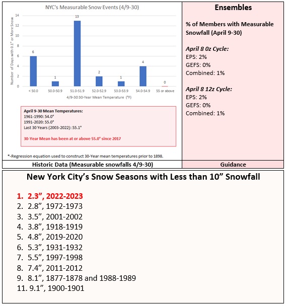
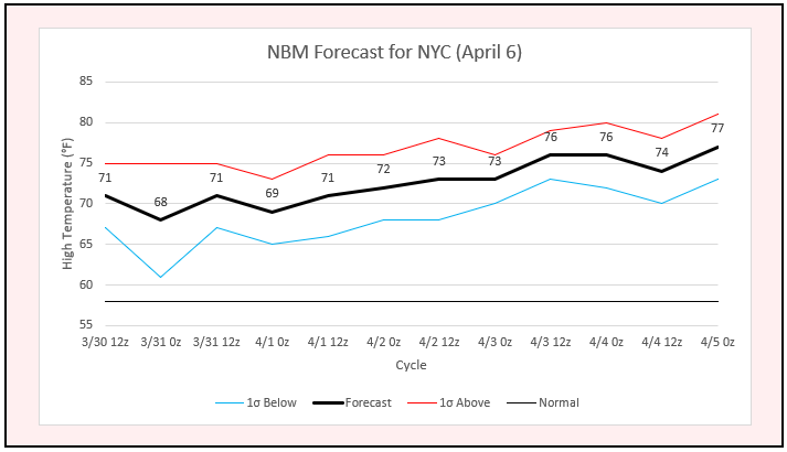
Today was a glorious early April day with deep blue skies, bright sunshine, and pleasant temperatures. In coming days, the calendar will seemingly be turned ahead closer to summer, as an impressive warmup evolves. Temperatures could reach the middle 80s by late in the week, possibly challenging or breaking some record highs on Friday. Overall, warmth appears likely to define April in much of the East. If the long-range guidance is accurate the first three weeks of the month could put April 2023 on a trajectory that could rank it among the 10 warmest Aprils on record in the northern Middle Atlantic region. The most recent April case to rank among the 10 warmest was: Boston: 51.7°, 2019 (5th warmest) Bridgeport: 54.0°, 2017 (1st warmest) Islip: 51.9°, 2019 (6th warmest) New Haven: 50.8°, 2022 (6th warmest) New York City-Central Park: 57.2°, 2017 (2nd warmest) New York City-JFK Airport: 55.1°, 2017 (2nd warmest) New York City-LaGuardia Airport: 57.6°, 2017 (2nd warmest) Newark: 57.2°, 2017 (4th warmest) Philadelphia: 59.0°, 2019 (3rd warmest) Poughkeepsie: 53.0°, 2017 (3rd warmest) White Plains: 53.9°, 2017 (2nd warmest) Yesterday, it was noted that based on historic climate data, New York City's current warmer climate regime, and the latest guidance, 2022-2023 will finish with the lowest seasonal snowfall on record (2.3"). Although it is far too soon to really look ahead, none of the ten seasons with less than 10" snowfall were followed by a second consecutive season with less than 10" snowfall. 1997-98 (3.5") and 1998-99 (12.7") came closest. Half of those seasons were followed by 30" or more snowfall. However, a very low snowfall amount cannot be ruled out. First, New York City is in a much warmer climate regime than had been the case for most of those prior seasons. Second, there is the risk of a strong El Niño following on the heels of a La Niña. Such a sequence often leads to very low snowfall. For now, all of that is just speculation. The ENSO Region 1+2 anomaly was +2.0°C and the Region 3.4 anomaly was 0.0°C for the week centered around March 29. For the past six weeks, the ENSO Region 1+2 anomaly has averaged +1.38°C and the ENSO Region 3.4 anomaly has averaged -0.08°C. Neutral ENSO conditions will likely prevail through at least mid-spring. The SOI was +21.70 today. The preliminary Arctic Oscillation (AO) was +0.276 today. On April 7 the MJO was in Phase 6 at an amplitude of 1.204 (RMM). The April 6-adjusted amplitude was 0.941 (RMM). Based on sensitivity analysis applied to the latest guidance, there is an implied 87% probability that New York City will have a warmer than normal April (1991-2020 normal). April will likely finish with a mean temperature near 57.3° (3.6° above normal). That would rank as the second warmest April on record.
-
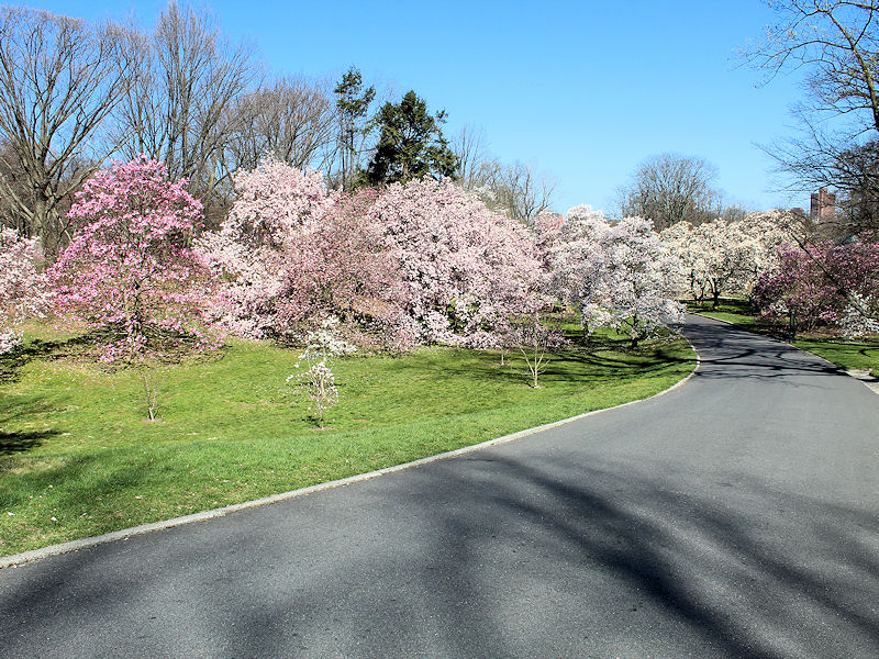
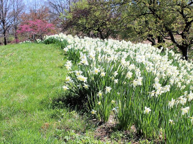
Some early April scenes at the New York Botanical Garden.


-
Cooler air returned to close the week. The cool weather will continue through tomorrow before another potentially impressive warmup develops. Under partly sunny skies, temperatures should be somewhat higher than they were today. Overall, warmth appears likely to define April in much of the East. If some of the long-range guidance is accurate the first three weeks of the month could put April 2023 on a trajectory that could rank it among the 10 warmest Aprils on record in the northern Middle Atlantic region. The most recent April case to rank among the 10 warmest was: Boston: 51.7°, 2019 (5th warmest) Bridgeport: 54.0°, 2017 (1st warmest) Islip: 51.9°, 2019 (6th warmest) New Haven: 50.8°, 2022 (6th warmest) New York City-Central Park: 57.2°, 2017 (2nd warmest) New York City-JFK Airport: 55.1°, 2017 (2nd warmest) New York City-LaGuardia Airport: 57.6°, 2017 (2nd warmest) Newark: 57.2°, 2017 (4th warmest) Philadelphia: 59.0°, 2019 (3rd warmest) Poughkeepsie: 53.0°, 2017 (3rd warmest) White Plains: 53.9°, 2017 (2nd warmest) In addition, given the forecast pattern and historical data, New York City has very likely seen 2022-2023 record the lowest seasonal snowfall on record with just 2.3" of snow. The old record of 2.8" was set during 1972-1973. The ENSO Region 1+2 anomaly was +2.0°C and the Region 3.4 anomaly was 0.0°C for the week centered around March 29. For the past six weeks, the ENSO Region 1+2 anomaly has averaged +1.38°C and the ENSO Region 3.4 anomaly has averaged -0.08°C. Neutral ENSO conditions will likely prevail through at least mid-spring. The SOI was +33.74 today. The preliminary Arctic Oscillation (AO) was +0.276 today. On April 6 the MJO was in Phase 6 at an amplitude of 0.937 (RMM). The April 5-adjusted amplitude was 0.866 (RMM). Based on sensitivity analysis applied to the latest guidance, there is an implied 82% probability that New York City will have a warmer than normal April (1991-2020 normal). April will likely finish with a mean temperature near 57.0° (3.3° above normal).
-
New York City will record its lowest seasonal snowfall on record for the 2022-2023 snow season. Based on historic data (no measurable snowfall has fallen during the 4/9-30 period with a 30-year mean temperature of 55For above) and guidance, this is now the very likely outcome.
-
Cooler air has returned to close the week. The cool weather will continue through the weekend before another potentially impressive warmup develops. In parts of Florida, excessive early spring warmth continued. Both Fort Myers and Tampa demolished their record warmest start to April. At Fort Myers, the temperature averaged 80.6°. The old record was 78.9° from 2017. At Tampa, the temperature averaged 79.3°. The old record was 76.9° from 2017. April 1-7, 2023 was both cities' warmest 7-day period so early in the season. Overall, warmth appears likely to define April in much of the East. If some of the long-range guidance is accurate the first three weeks of the month could put April 2023 on a trajectory that could rank it among the 10 warmest Aprils on record in the northern Middle Atlantic region. The ENSO Region 1+2 anomaly was +2.0°C and the Region 3.4 anomaly was 0.0°C for the week centered around March 29. For the past six weeks, the ENSO Region 1+2 anomaly has averaged +1.38°C and the ENSO Region 3.4 anomaly has averaged -0.08°C. Neutral ENSO conditions will likely prevail through at least mid-spring. The SOI was +23.94 today. The preliminary Arctic Oscillation (AO) was -0.001 today. On April 5 the MJO was in Phase 6 at an amplitude of 0.859 (RMM). The April 4-adjusted amplitude was 0.966 (RMM). Based on sensitivity analysis applied to the latest guidance, there is an implied 80% probability that New York City will have a warmer than normal April (1991-2020 normal). April will likely finish with a mean temperature near 57.0° (3.3° above normal).
-
Report: Another Year of Record Heat for the Oceans
donsutherland1 replied to donsutherland1's topic in Climate Change
I did. This is troubling, as it’s a vital large-scale current. The paper was published in Nature. https://www.nature.com/articles/s41586-023-05762-w -
LGA missed its record of 80. EWR set a new record at 81.
-
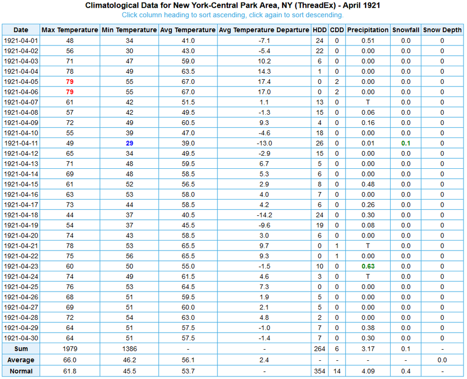
The final high in NYC was 80. That broke the record of 79 that was set in 1912 and tied in 1921 and 1947.
-
Temperatures surged to near record and record high values across the region as the early fog burned off. Prior to the onset of a sea breeze, Islip crushed its daily record. Daily records included: Islip: 78° (old record: 71°, 1991 and 2010) New York City-Central Park: 79° (tied record set in 1912 and tied in 1921 and 1947) New York City-JFK Airport: 74° (old record: 73°, 2010) Newark: 81° (old record: 80°, 1947) Atlantic City saw the mercury reach a toasty 87°. Cooler air will now return to end the week. The cool weather will continue through the weekend before another potentially impressive warmup develops. If some of the long-range guidance is accurate the first three weeks of the could put April 2023 on a trajectory that could rank it among the 10 warmest Aprils on record. The ENSO Region 1+2 anomaly was +2.0°C and the Region 3.4 anomaly was 0.0°C for the week centered around March 29. For the past six weeks, the ENSO Region 1+2 anomaly has averaged +1.38°C and the ENSO Region 3.4 anomaly has averaged -0.08°C. Neutral ENSO conditions will likely prevail through at least mid-spring. The SOI was +12.98 today. The preliminary Arctic Oscillation (AO) was +0.185 today. On April 4 the MJO was in Phase 5 at an amplitude of 0.962 (RMM). The April 3-adjusted amplitude was 1.171 (RMM).
-
The latest data now shows the temperature getting close to 80° in New York City. Newark should rise into the lower 80s.
-
While the region was caught in low clouds, a chilly onshore breeze, drizzle, and fog, parts of the Middle Atlantic area saw temperatures surge to record highs. Records included: Baltimore: 84° (tied record set in 2010) Sterling, VA: 88° (old record: 86°, 2010) Washington, DC: 87° (old record: 86°, 1910) The warmest air so far this season will push into the region for tomorrow. Temperatures will soar into the middle and upper 70s in New York City and the lower 80s in parts of New Jersey southward. Following some late-day showers and thunderstorms, cooler air will return to end the week. The cool weather will continue through the weekend before another potentially impressive warmup develops. Overall, the first week of April will turn out warmer than normal. As has been the case throughout the winter and early part of spring, the coldest air will remain confined largely to western and central North America. Some of the guidance brings a brief shot of the cooler air into the East early in the second week of April, but the EPS weeklies have backed off on the cold. If some of the long-range guidance is accurate the first three weeks of the could put April 2023 on a trajectory that could rank it among the 10 warmest Aprils on record. The ENSO Region 1+2 anomaly was +2.0°C and the Region 3.4 anomaly was 0.0°C for the week centered around March 29. For the past six weeks, the ENSO Region 1+2 anomaly has averaged +1.38°C and the ENSO Region 3.4 anomaly has averaged -0.08°C. Neutral ENSO conditions will likely prevail through at least mid-spring. The SOI was +1.87 today. The preliminary Arctic Oscillation (AO) was +0.567 today. On April 3 the MJO was in Phase 5 at an amplitude of 1.165 (RMM). The April 2-adjusted amplitude was 1.277 (RMM).
-
At the short range, there are EFI tools for CAPE and CAPE Shear. At the extended range, there is temperature, precipitation, and multi-parameter (includes a combination of temperature, precipitation, sea-level pressure, and wind gust).
-
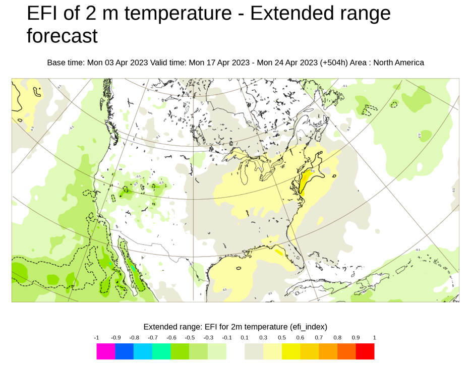
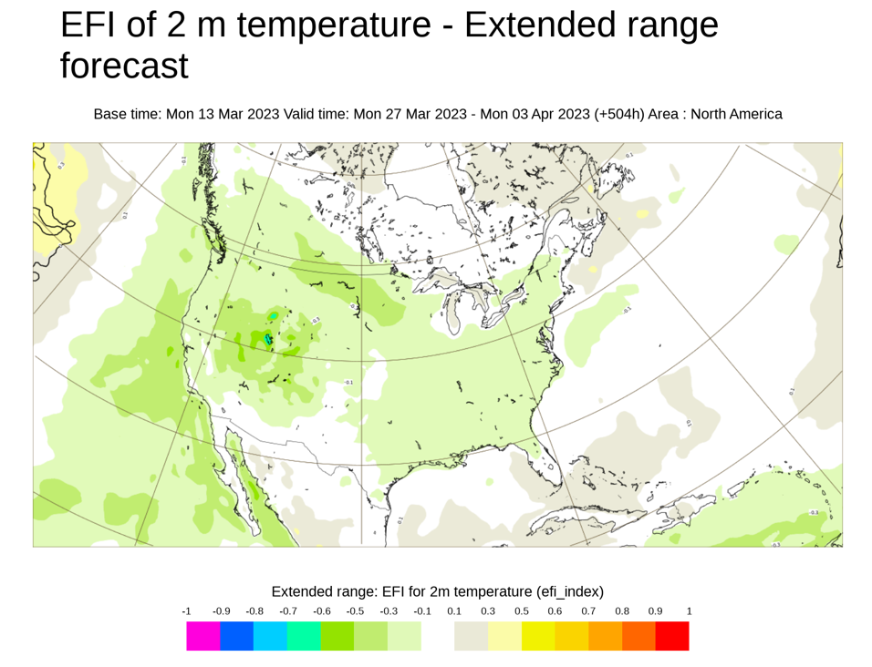
The ensemble spread increases with time, which weakens long-term signals. Beyond 2 weeks, the weekly forecasts lose their skill. The EFI places ensemble values within quantiles based on statistical occurrences. quantile 1 (1 in 100 occasions less than value shown), quantile 10 (10 in 100 occasions less than value shown), quantile 50 (climate (M-climate) median), quantile 90 (10 in 100 occasions greater than value shown), quantile 99 (1 in 100 occasions greater than value shown). EFI values between 0.5 to 0.8 (irrespective of sign) can be generally regarded as signifying that “unusual” weather is likely, EFI values above 0.8 (irrespective of sign) as usually signifying that “very unusual” or extreme weather is likely. For more information: https://confluence.ecmwf.int/display/FUG/Extreme+Forecast+Index+-+EFI,+and+Shift+of+Tails+-+SOT Typically, the Week 3 idea has little or no EFI signal. That there is an expansive albeit weak signal (0.3-0.5) there suggests that it is worth monitoring things. A signal between -0.3 and 0.3 is often too weak to be very useful. Here's an EFI map from the same lead time for March 27-April 3: Selected Outcomes for March 27-April 3: Bismarck: 7th coldest (Start of period of record: 1875) Flagstaff: 18th coldest (Start of period of record: 1899) Glasgow: 11th coldest (Start of period of record: 1894) Las Vegas: 11th coldest (Start of period of record: 1937) Salt Lake City: 29th coldest (Start of period of record: 1875) Ensemble forecasts can be incorrect. So one has to watch to see how things evolve. Typically, if a risk assessment is correct, the signal should hold or strengthen as the event draws closer.
-
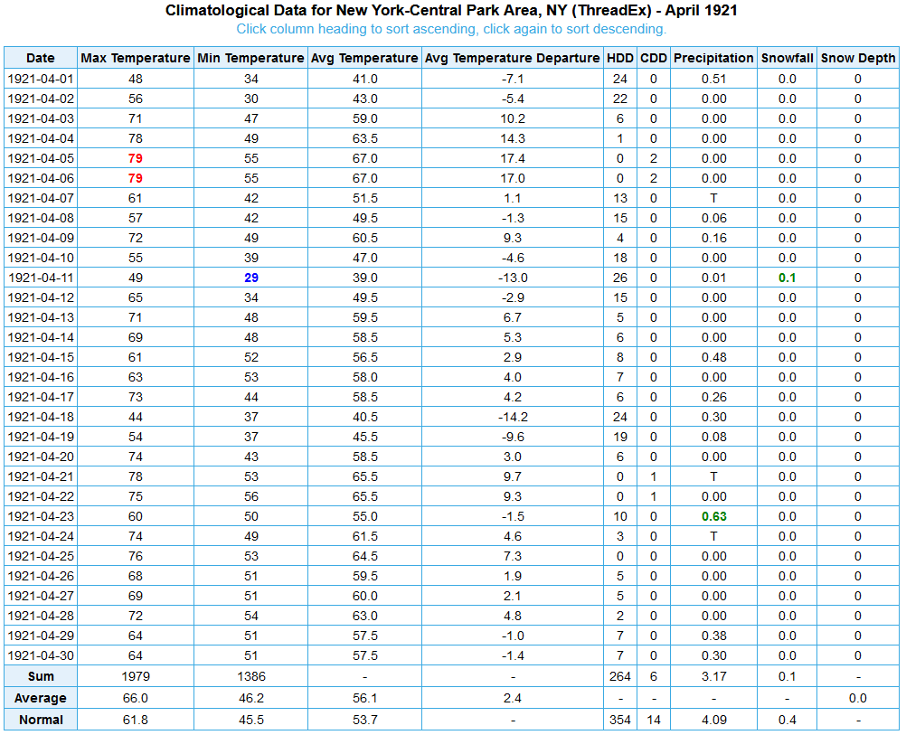
It's too soon to be sure. The potential exists for much above normal readings around mid-month. The signal for excessive warmth shows up on the weeklies and the long-range Extreme Forecast Index (EFI). A GFS run showed readings in the high 80s at one point. The picture should become clearer as mid-month approaches. But a top 10--maybe top 5--warmest April is plausible given the guidance. Such cases have typically seen the temperature reach or exceed 85° for the monthly high. 1921, which ranks as the 6th warmest April, is the lone exception with a monthly high of 79°.
-
The temperature reached 73° in Central Park today. Thursday should be at least several degrees warmer.
-
Tomorrow will be briefly cooler until much warmer air surges into the region for Thursday. Some thunderstorms are possible later in the day or during the evening. Overall, the first week of April will turn out warmer than normal. As has been the case throughout the winter and early part of spring, the coldest air will remain confined largely to western and central North America. Some of the guidance brings a brief shot of the cooler air into the East early in the second week of April, but the EPS weeklies have backed off on the cold. If some of the long-range guidance is accurate the first three weeks of the could put April 2023 on a trajectory that could rank it among the 10 warmest Aprils on record. The ENSO Region 1+2 anomaly was +2.0°C and the Region 3.4 anomaly was 0.0°C for the week centered around March 29. For the past six weeks, the ENSO Region 1+2 anomaly has averaged +1.38°C and the ENSO Region 3.4 anomaly has averaged -0.08°C. Neutral ENSO conditions will likely prevail through at least mid-spring. The SOI was -6.49 today. The preliminary Arctic Oscillation (AO) was +0.130 today. On April 2 the MJO was in Phase 5 at an amplitude of 1.279 (RMM). The April 1-adjusted amplitude was 1.079 (RMM).
-
Tomorrow will be even warmer than today. Readings will soar well into the 60s across the region. Overall, the first week of April will likely turn out warmer than normal. As has been the case throughout the winter and early part of spring, the coldest air will remain confined largely to western and central North America. Some of the guidance brings a brief shot of the cooler air into the East for the second week of April, but the EPS weeklies have backed off on the cold. Historic experience with very low snowfall totals through February argues that a very snowy March or big snowstorm during March or April are unlikely. There were 16 winters that had less than 8" of snowfall through February in New York City. Just two (13%) had a 6" or greater snowstorm during March or April: 1889-1890: 6.0" on March 19th and 1991-1992: 6.2" on March 19th. With just 2.3" snowfall through March 19, New York City is now extremely likely to finish the season with less than 10" of snow. Since 1869-70, all 10 winters with less than 8.5" of snow through March 19th wound up with less than 10" of seasonal snowfall. New York City is currently on a path that could culminate in its setting a new record for lowest seasonal snowfall. The ENSO Region 1+2 anomaly was +2.0°C and the Region 3.4 anomaly was 0.0°C for the week centered around March 29. For the past six weeks, the ENSO Region 1+2 anomaly has averaged +1.38°C and the ENSO Region 3.4 anomaly has averaged -0.08°C. Neutral ENSO conditions will likely prevail through at least mid-spring. The SOI was -7.57 today. The preliminary Arctic Oscillation (AO) was -0.659 today. On April 1 the MJO was in Phase 5 at an amplitude of 0.706 (RMM). The March 31-adjusted amplitude was 0.452 (RMM).
-
This morning's chill will be short-lived. Temperatures will turn much milder tomorrow. Overall, the first week of April will likely turn out warmer than normal. As has been the case throughout the winter and early part of spring, the coldest air will remain confined largely to western and central North America. Some of the guidance now brings the cooler air into the East for the second week of April, but uncertainty still exists. Historic experience with very low snowfall totals through February argues that a very snowy March or big snowstorm during March or April are unlikely. There were 16 winters that had less than 8" of snowfall through February in New York City. Just two (13%) had a 6" or greater snowstorm during March or April: 1889-1890: 6.0" on March 19th and 1991-1992: 6.2" on March 19th. With just 2.3" snowfall through March 19, New York City is now extremely likely to finish the season with less than 10" of snow. Since 1869-70, all 10 winters with less than 8.5" of snow through March 19th wound up with less than 10" of seasonal snowfall. New York City is currently on a path that could culminate in its setting a new record for lowest seasonal snowfall. The ENSO Region 1+2 anomaly was +2.0°C and the Region 3.4 anomaly was 0.0°C for the week centered around March 22. For the past six weeks, the ENSO Region 1+2 anomaly has averaged +1.20°C and the ENSO Region 3.4 anomaly has averaged -0.17°C. Neutral ENSO conditions will likely prevail through at least mid-spring. The SOI was -13.56 today. The preliminary Arctic Oscillation (AO) was -0.225 today. On March 31 the MJO was in Phase 5 at an amplitude of 0.437 (RMM). The March 30-adjusted amplitude was 0.502 (RMM).
-
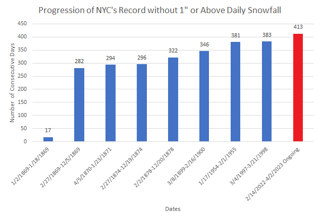
New York City has now surpassed its prior mark for most consecutive days without 1" or more snowfall by 30 days. That margin will very likely swell over coming months, as it appears no such snowfall is likely through the remainder of the 2022-2023 snow season.