donsutherland1
-
Posts
23,765 -
Joined
Content Type
Profiles
Blogs
Forums
American Weather
Media Demo
Store
Gallery
Everything posted by donsutherland1
-
Two Mdt to high impact events NYC subforum; wknd Jan 6-7 Incl OBS, and mid week Jan 9-10 (incl OBS). Total water equiv by 00z/11 general 2", possibly 6" includes snow-ice mainly interior. RVR flood potential increases Jan 10 and beyond. Damaging wind.
donsutherland1 replied to wdrag's topic in New York City Metro
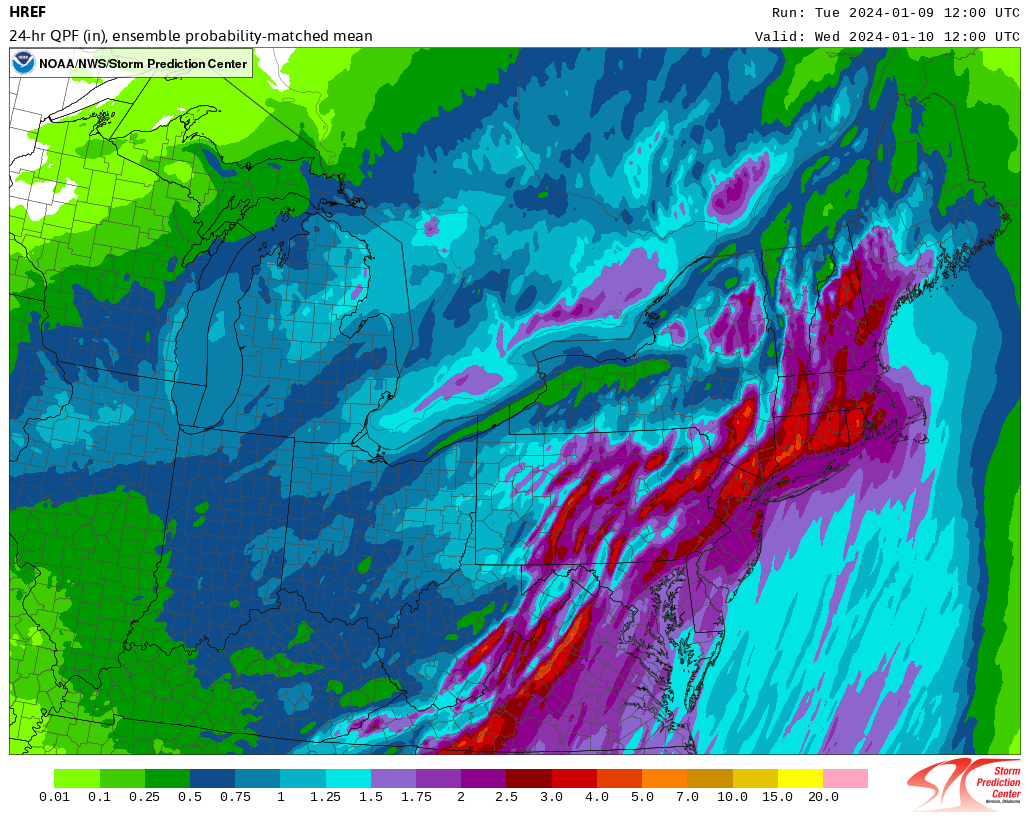
12z HREF Forecast Precipitation (24-hours):
- 3,610 replies
-
- 1
-

-
- snow
- heavy rain
- (and 5 more)
-
Two Mdt to high impact events NYC subforum; wknd Jan 6-7 Incl OBS, and mid week Jan 9-10 (incl OBS). Total water equiv by 00z/11 general 2", possibly 6" includes snow-ice mainly interior. RVR flood potential increases Jan 10 and beyond. Damaging wind.
donsutherland1 replied to wdrag's topic in New York City Metro
The 0z HREF wind product brings 70 mph gusts to the south shore of Long Island (mean) but 60 mph to parts of Long Island (minimum). The range seems to have narrowed from yesterday's 12z guidance and today's 12z cycle is running. Let's see where things converge. 60 mph with widespread 50 mph gusts would still be nasty in a situation where the ground is saturated.- 3,610 replies
-
- 2
-

-
-
- snow
- heavy rain
- (and 5 more)
-
Those of us who read your work and your commentary know the time, thought and effort that goes into your forecasts. There's no question that they are original content. Ignore the noise, don't let it bother you, and keep doing what you're doing.
-
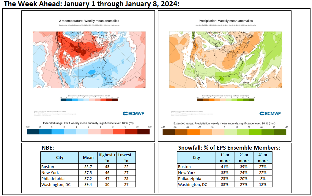
That cities such as Boston, New York, and Philadelphia have seen below normal snowfall so far this winter does not necessarily mean that they will have a horrible season. Most of the seasonal snowfall during strong El Niño events falls after January 15th. For example, at New York City, approximately 75% of seasonal snowfall occurs after January 15th in such cases and 50% on or after February 1st. For what it's worth, my seasonal snowfall guesses for select cities were as follows: DCA _NYC _BOS __ ORD _DTW _BUF ____ DEN _ SEA _ BTV 11.5 15.0 27.5 27.0 38.5 85.0 56.5 1.2 70.0
-
Congratulations on the wedding.
-
Today was a tranquil day. Under partly sunny skies, the temperature rose into the mild 40s across the northern Mid-Atlantic region. However, the calm is about to be shattered. A severe storm could bring a heavy windswept rain to much of the region late tomorrow into Wednesday. The potential exists for a 1"-3" rainfall with locally higher amounts, damaging winds with gusts of 50 mph to 60 mph, and possibly major coastal flooding. Significant beach erosion is also likely. Temperatures will likely surge into the middle 50s in New York City and Newark and toward or above 60° in Baltimore, Philadelphia, and Washington, DC. Another strong storm could bring additional rain and wind to the region Friday into Saturday. Meanwhile, a genuine Arctic air mass will begin advancing into the Pacific Northwest and Northern Plains later this week. Severe cold is likely in the affected region. Afterward, this cold air could come eastward in modified fashion. That could set the stage for the coldest period so far this winter beginning on Sunday or Monday. The ENSO Region 1+2 anomaly was +1.0°C and the Region 3.4 anomaly was +1.9°C for the week centered around January 3. For the past six weeks, the ENSO Region 1+2 anomaly has averaged +1.38°C and the ENSO Region 3.4 anomaly has averaged +1.97°C. A basinwide El Niño event is ongoing. The SOI was +1.37 today. The preliminary Arctic Oscillation (AO) was -1.515 today. Strong blocking in the final week of November, as occurred this year, has often been followed by frequent blocking in December and January. On January 6 the MJO was in Phase 3 at an amplitude of 1.484 (RMM). The January 5-adjusted amplitude was 2.023 (RMM). Based on sensitivity analysis applied to the latest guidance, there is an implied 57% probability that New York City will have a warmer than normal January (1991-2020 normal). January will likely finish with a mean temperature near 34.4° (0.7° above normal).
-
The CFS has no real skill at this timeframe.
-
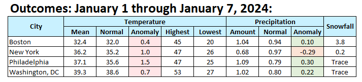
Final January 1-7, 2024 Numbers: Temperatures were modestly warmer than normal but somewhat cooler than the NBE/ECMWF weekly forecast. Central Park received its first measurable snowfall of the season on January 6th, which was tied with 1891-92 for the 13th latest on record. The record was set last winter with the first measurable snow falling on February 1st.

-
The pattern remains active following the region's first winter storm Saturday and Sunday. January 9-10, 2024: A severe rain and wind storm will affect the region later Tuesday into Wednesday. Winds could gust past 60 mph. A general 1"-3" rainfall with locally higher amounts of 4" seems likely. River and coastal flooding is likely. Trees could be uprooted. Significant beach erosion is also likely. Temperatures will likely surge well into the 50s in New York City and Newark and possibly approach or reach 60° in Philadelphia, Baltimore, and Washington, DC. January 12-13, 2024: Another high confidence event. There is strong model support for a very deep storm to cut to the Great Lakes. Mild temperatures, gusty southeast winds, and heavy rainfall (possibly 1"-2") appear likely. January 16-18, 2024: Low confidence. The 1/8 0z ECMWF shows a significant snowstorm for the region. There will be strong blocking at the time, though the NAO will be rising fast. Arctic air will be present in at least the central United States. Such developments have coincided with snowfalls before. The GGEM and GFS aren't showing a similar storm for this timeframe. Therefore, a quieter scenario featuring little more than an Arctic frontal passage on or around January 15th or 16th followed by generally dry conditions is also on the table. If there were a shortwave that could impact the region, what might it look like, especially if it were cold enough for snow? Filtering for teleconnections (AO -3.5 to -1.5, NAO-, and PNA+ as currently forecast by the GEFS), there were 9 storms that brought 2" or more snow to at least one of the following cities during January 5-25, 1950-2023: Boston, New York City, Philadelphia, or Washington, DC. Here's how those cities fared for those storms: Boston: 2" or more: 67%; 4" or more: 44%; 6" or more: 11% New York City: 2" or more: 22%; 4" or more: 11%; 6" or more: 11% Philadelphia: 2" or more: 33%; 4" or more: 11%; 6" or more: 11% Washington, DC: 2" or more: 22%; 4" or more: 11%; 6" or more: 11% The 6"+ storm was the January 1996 blizzard. It should be noted that there are many cases where there were no storms for the filtered teleconnections. So, there is no assurance that the period of blocking will lead to anything, much less a significant storm. That's far out in the extended range where model skill is low, so one can't rule out either the big ECMWF idea or the non-storm GFS/GGEM solutions. For now, there's a window of possible opportunity, as hinted at by the 0z ECMWF. The evolution of ensemble solutions will provide more insight in coming days.
-
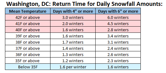
An offboard discussion arose concerning the absence of big East Coast snowstorms and a possible connection to temperatures. While warmer winters have reached a point where seasonal snowfall is declining in parts of the Mid-Atlantic region, there can still be big snowstorms during warm winters e.g., 2015-16. However, the frequency of 4" and 6" daily snowfall during winters (December-February) decreases.
-
January 6-7, 2024 Winter Storm Obs Thread
donsutherland1 replied to WxWatcher007's topic in New England
You’re welcome. Happy New Year to you, as well, Ken. -
January 6-7, 2024 Winter Storm Obs Thread
donsutherland1 replied to WxWatcher007's topic in New England
3.1" -
It will be a race between the timing of the sunshine and the arrival of cooler air. The high will likely be in the morning.
-
Two Mdt to high impact events NYC subforum; wknd Jan 6-7 Incl OBS, and mid week Jan 9-10 (incl OBS). Total water equiv by 00z/11 general 2", possibly 6" includes snow-ice mainly interior. RVR flood potential increases Jan 10 and beyond. Damaging wind.
donsutherland1 replied to wdrag's topic in New York City Metro
Once one get east of the Hutchinson River Parkway, snowfall amounts fell off sharply. They were even less once once reached the Long Island Sound.- 3,610 replies
-
- 1
-
-
- snow
- heavy rain
- (and 5 more)
-
Two Mdt to high impact events NYC subforum; wknd Jan 6-7 Incl OBS, and mid week Jan 9-10 (incl OBS). Total water equiv by 00z/11 general 2", possibly 6" includes snow-ice mainly interior. RVR flood potential increases Jan 10 and beyond. Damaging wind.
donsutherland1 replied to wdrag's topic in New York City Metro
Those positive numbers indicate that at least 10% of ensemble members are showing an extreme event. The higher the number, the more extreme the event e.g., 2 is more extreme than 1.- 3,610 replies
-
- 1
-
-
- snow
- heavy rain
- (and 5 more)
-
Two Mdt to high impact events NYC subforum; wknd Jan 6-7 Incl OBS, and mid week Jan 9-10 (incl OBS). Total water equiv by 00z/11 general 2", possibly 6" includes snow-ice mainly interior. RVR flood potential increases Jan 10 and beyond. Damaging wind.
donsutherland1 replied to wdrag's topic in New York City Metro
Among the top 10%-15% of such events for this time of year in terms of rain and wind. -
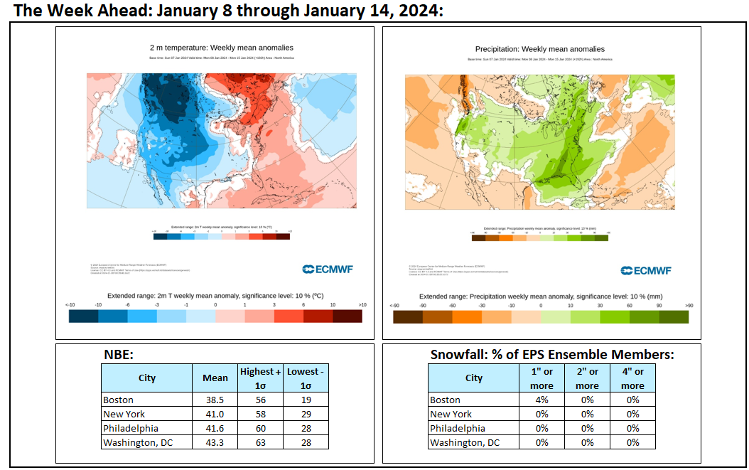
Week ahead numbers: Warm and wet in the northern Mid-Atlantic and southern New England areas. Arctic air arrives in the Northwest and Northern Plains.

-
Two Mdt to high impact events NYC subforum; wknd Jan 6-7 Incl OBS, and mid week Jan 9-10 (incl OBS). Total water equiv by 00z/11 general 2", possibly 6" includes snow-ice mainly interior. RVR flood potential increases Jan 10 and beyond. Damaging wind.
donsutherland1 replied to wdrag's topic in New York City Metro
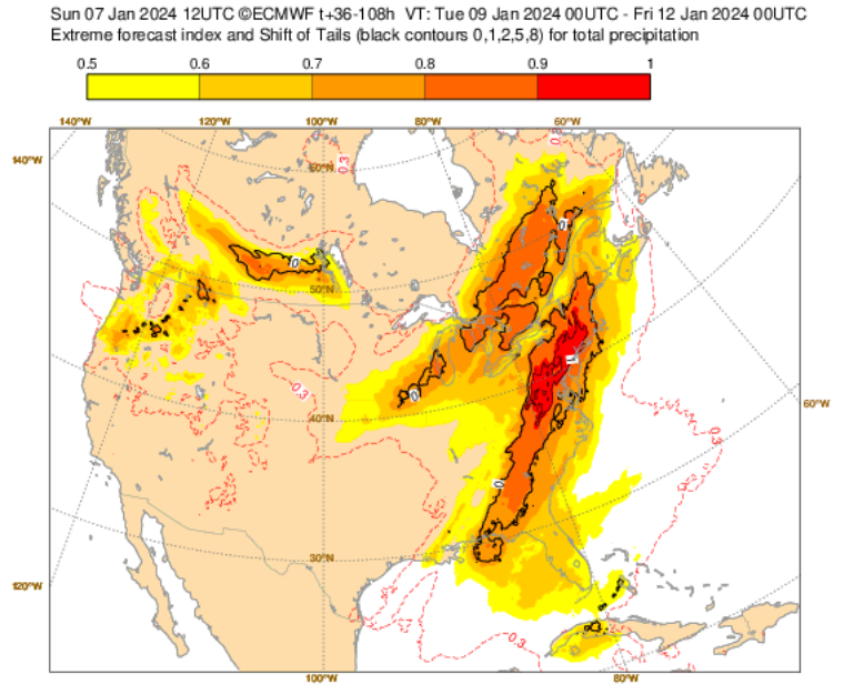
The severe storm for later Tuesday into Wednesday (January 9-10) remains on track. In terms of deviations from normal, both in terms of precipitation and wind, it will be an infrequent event. Extreme Forecast Index (EFI) data is below. Wind Gusts: Precipitation: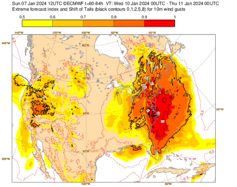
- 3,610 replies
-
- 2
-
-

-
- snow
- heavy rain
- (and 5 more)
-
It could be given the evolution of ENSO, especially if the PDO- weakens.
-
In the wake of the region's first winter storm, a severe storm could bring a heavy windswept rain to much of the region during the middle of next week. The potential exists for a 1"-3" rainfall with locally higher amounts, damaging winds, and possibly significant coastal flooding. Significant beach erosion is also likely. Temperatures could surge into the 50s. Late next week, a genuine Arctic air mass will likely begin pushing into the Pacific Northwest and Northern Plains. Severe cold is likely in the affected region. Afterward, this cold air could come eastward in modified fashion. That could set the stage for the coldest period so far this winter. The ENSO Region 1+2 anomaly was +0.8°C and the Region 3.4 anomaly was +2.0°C for the week centered around December 27. For the past six weeks, the ENSO Region 1+2 anomaly has averaged +1.55°C and the ENSO Region 3.4 anomaly has averaged +2.00°C. A basinwide El Niño event is ongoing. The SOI was +2.50 today. The preliminary Arctic Oscillation (AO) was -1.671 today. Strong blocking in the final week of November, as occurred this year, has often been followed by frequent blocking in December and January. On January 5 the MJO was in Phase 3 at an amplitude of 2.023 (RMM). The January 4-adjusted amplitude was 2.355 (RMM). Based on sensitivity analysis applied to the latest guidance, there is an implied 57% probability that New York City will have a warmer than normal January (1991-2020 normal). January will likely finish with a mean temperature near 34.4° (0.7° above normal).
-
Two Mdt to high impact events NYC subforum; wknd Jan 6-7 Incl OBS, and mid week Jan 9-10 (incl OBS). Total water equiv by 00z/11 general 2", possibly 6" includes snow-ice mainly interior. RVR flood potential increases Jan 10 and beyond. Damaging wind.
donsutherland1 replied to wdrag's topic in New York City Metro
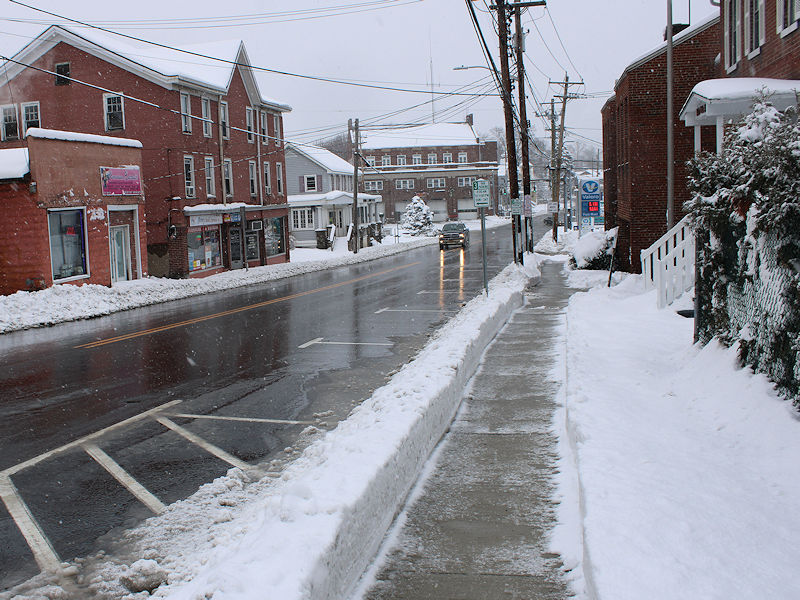
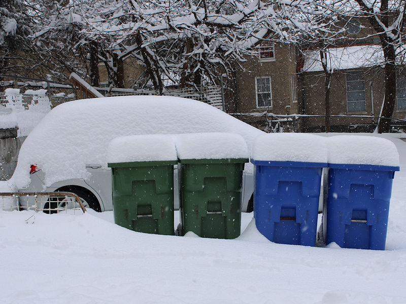
Photos from the recent storm. First is from Near Harriman, NY. The second and third are from Middletown, NY.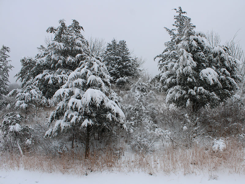
- 3,610 replies
-
- 6
-
-
- snow
- heavy rain
- (and 5 more)
-
Two Mdt to high impact events NYC subforum; wknd Jan 6-7 Incl OBS, and mid week Jan 9-10 (incl OBS). Total water equiv by 00z/11 general 2", possibly 6" includes snow-ice mainly interior. RVR flood potential increases Jan 10 and beyond. Damaging wind.
donsutherland1 replied to wdrag's topic in New York City Metro
The rain switched to sleet and then snow in Larchmont. Even as it’s only a coating, it is infinitely better than nothing at all.
- 3,610 replies
-
- 12
-
-
- snow
- heavy rain
- (and 5 more)
-
Two Mdt to high impact events NYC subforum; wknd Jan 6-7 Incl OBS, and mid week Jan 9-10 (incl OBS). Total water equiv by 00z/11 general 2", possibly 6" includes snow-ice mainly interior. RVR flood potential increases Jan 10 and beyond. Damaging wind.
donsutherland1 replied to wdrag's topic in New York City Metro
It switched to snow here and the ground is coated. -
Two Mdt to high impact events NYC subforum; wknd Jan 6-7 Incl OBS, and mid week Jan 9-10 (incl OBS). Total water equiv by 00z/11 general 2", possibly 6" includes snow-ice mainly interior. RVR flood potential increases Jan 10 and beyond. Damaging wind.
donsutherland1 replied to wdrag's topic in New York City Metro
It’s now snowing in Larchmont. The ground is coated.- 3,610 replies
-
- 2
-
-
- snow
- heavy rain
- (and 5 more)
-
Two Mdt to high impact events NYC subforum; wknd Jan 6-7 Incl OBS, and mid week Jan 9-10 (incl OBS). Total water equiv by 00z/11 general 2", possibly 6" includes snow-ice mainly interior. RVR flood potential increases Jan 10 and beyond. Damaging wind.
donsutherland1 replied to wdrag's topic in New York City Metro
Fortunately, there should be more opportunities in coming weeks.- 3,610 replies
-
- 2
-
-
- snow
- heavy rain
- (and 5 more)