donsutherland1
-
Posts
23,765 -
Joined
Content Type
Profiles
Blogs
Forums
American Weather
Media Demo
Store
Gallery
Everything posted by donsutherland1
-
With a low temperature of 49°, New York City saw its first temperature below 50° since May 13th this morning. Tomorrow morning will again see the temperature fall into the 40s. Saturday will turn briefly milder before cooler air returns Sunday or Monday. Another particularly strong cold shot is likely near mid-month before a potential warming trend develops. In the Southwest and parts of California, near record and record heat continued continued to fade. The heat will dissipate by the weekend. Phoenix recorded its 17th consecutive record-tying or record-breaking high temperature. Tucson reached 100° for the 109th time this year, breaking the record of 108 days that was set in 2020. The NAO fell to a preliminary -2.751 on September 24th (all-time September record: -2.371, September 12, 1971). That was the 9th lowest value on record. La Niña winters following September cases where the NAO fell to -1.900 or below featured a predominantly positive NAO. The most recent such winters were 2016-2017 and 2022-2023. The mean temperatures for those winters in New York City were 39.3° and 41.0° respectively. The 1991-2020 normal value is 36.2°. A warmer outcome is favored by the September run of the C3S multi-model forecast for Winter 2024-2025. Weekly ENSO data remains unavailable due to the disruptive impact Hurricane Helene's floods had on NCEI in Asheville. The ENSO Region 1+2 anomaly was +0.2°C and the Region 3.4 anomaly was -0.5°C for the week centered around September 18. For the past six weeks, the ENSO Region 1+2 anomaly has averaged -0.20°C and the ENSO Region 3.4 anomaly has averaged -0.18°C. Neutral ENSO conditions will likely evolve into a La Niña event during the fall. The SOI was +7.09 today. The preliminary Arctic Oscillation (AO) was -1.926 today. Based on sensitivity analysis applied to the latest guidance, there is an implied 56% probability that New York City will have a warmer than normal October (1991-2020 normal). October will likely finish with a mean temperature near 58.4° (0.5° above normal).
-
Hopefully, it doesn't have a cold bias. February is probably the best month for the East (largely driven by the ECMWF input). December-January are quite warm.
-
The United States and probably all of North America has never seen anything like this autumn heatwave. The combination of extreme warmth and persistence is almost uncertainly unmatched. "Unprecedented" doesn't adequately describe what has occurred. During this heatwave, the September monthly record of 117° on 9/28, the October record of 113° (10/1, 10/6), and 10/1-7 mean temperature of 96.1° at Phoenix were all beyond 1000-year events (less than 0.1% chance of occurring in any year). All of this happened during the same heatwave.
-
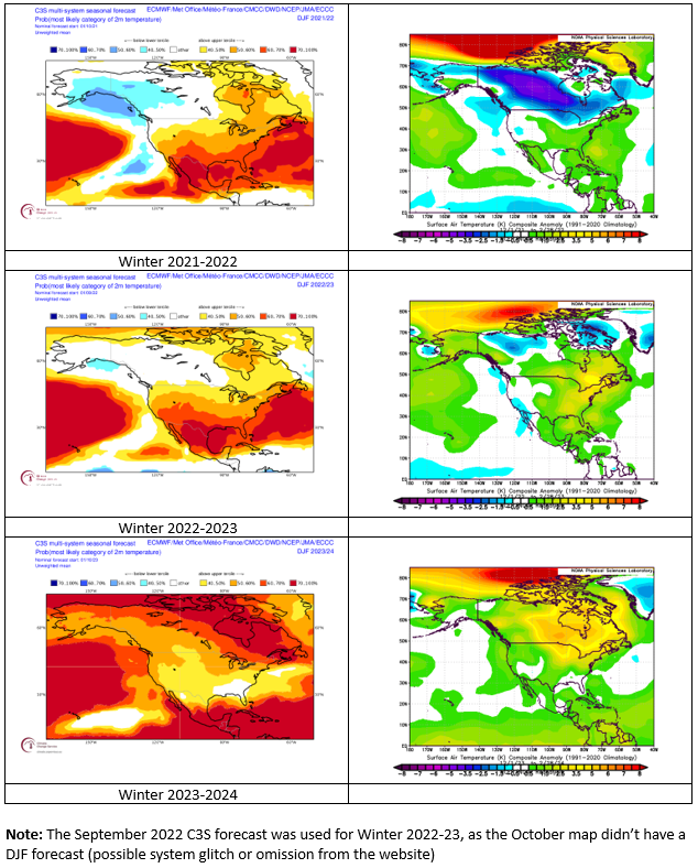
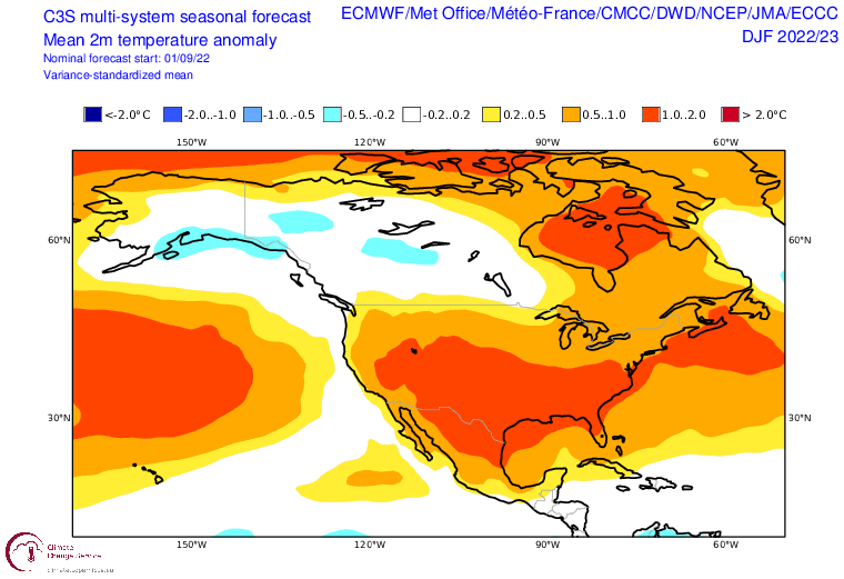
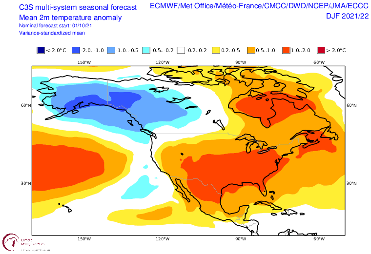
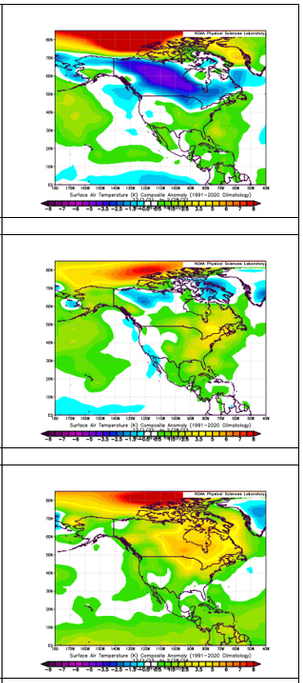
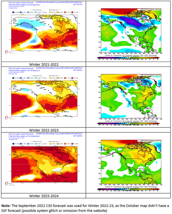
I thought I had posted the anomalies. My error. Here they are. October 2021 for Winter 2021-22: September 2022 for Winter 2022-23 (October didn't have a DJF map): October 2023 for Winter 2023-24: Top to Bottom: Winter 2021-22, 2022-23, 2023-24 Outcomes:
-
Here are the forecasts. For one year, I had to use the September, not October forecast.
-
Yes. I agree. Hopefully, there won't be near wall-to-wall warmth.
-
Taken literally, it would be better than the past two winters. I still suspect that the Great Lakes region will be coooler than what is currently shown.
-
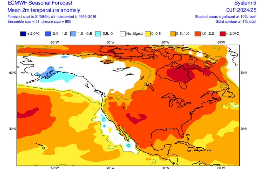
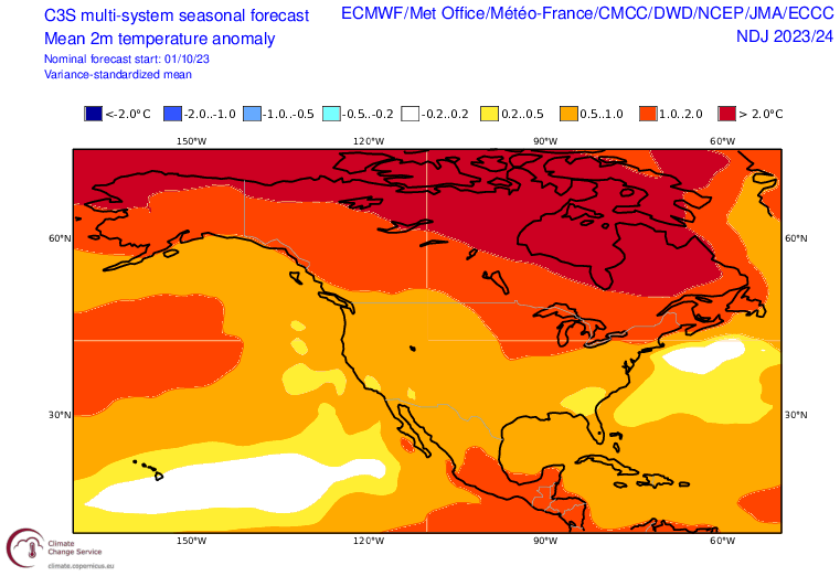
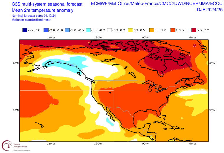
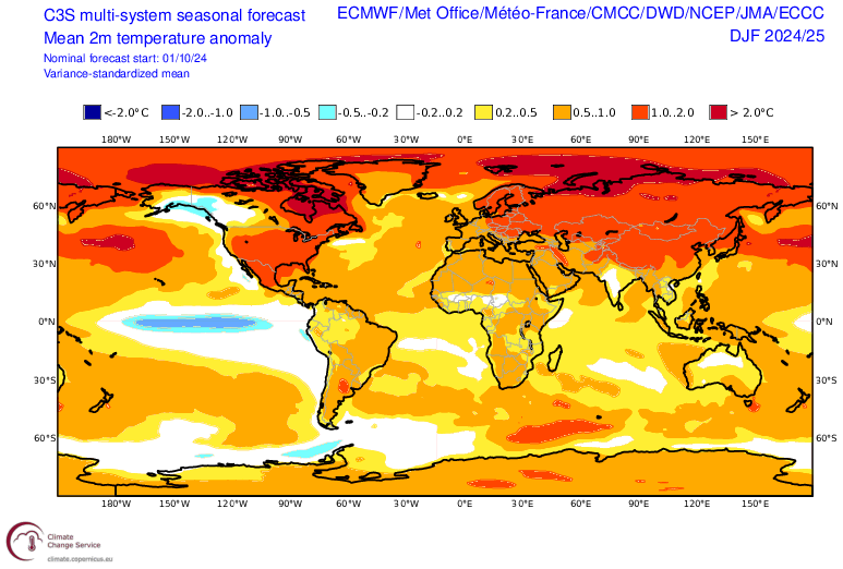
Just released C3S multi-model outlook for December 2024-February 2025: North America: World:
-
New York City could see its first temperature below 50° since May 13th tomorrow morning and again Friday morning. Saturday will turn briefly milder before cooler air returns. Another particularly strong cold shot is likely near mid-month before a potential warming trend develops. Hurricane Milton will make landfall on Florida's west coast this evening as a Category 3. It will bring a devastating storm surge inland. Landfall will likely occur just south of the Tampa Bay area. In the Southwest and parts of California, near record and record heat continued continued to fade. The heat will dissipate by the weekend. The NAO fell to a preliminary -2.751 on September 24th (all-time September record: -2.371, September 12, 1971). That was the 9th lowest value on record. La Niña winters following September cases where the NAO fell to -1.900 or below featured a predominantly positive NAO. The most recent such winters were 2016-2017 and 2022-2023. The mean temperatures for those winters in New York City were 39.3° and 41.0° respectively. The 1991-2020 normal value is 36.2°. A warmer outcome is favored by the September run of the C3S multi-model forecast for Winter 2024-2025. Weekly ENSO data remains unavailable due to the dirsuptive impact Hurricane Helene's floods had on NCEI in Asheville. The ENSO Region 1+2 anomaly was +0.2°C and the Region 3.4 anomaly was -0.5°C for the week centered around September 18. For the past six weeks, the ENSO Region 1+2 anomaly has averaged -0.20°C and the ENSO Region 3.4 anomaly has averaged -0.18°C. Neutral ENSO conditions will likely evolve into a La Niña event during the fall. The SOI was +4.64 today. The preliminary Arctic Oscillation (AO) was -2.260 today. Based on sensitivity analysis applied to the latest guidance, there is an implied 54% probability that New York City will have a warmer than normal October (1991-2020 normal). October will likely finish with a mean temperature near 58.3° (0.4° above normal).
-
Occasional Thoughts on Climate Change
donsutherland1 replied to donsutherland1's topic in Climate Change
It's tragic that the State is seeking to impose ignorance on its children. -
Occasional Thoughts on Climate Change
donsutherland1 replied to donsutherland1's topic in Climate Change
World Weather Attribution has published its study on Hurricane Helene. Climate change played an important role in making it a worse storm than it would have been without climate change. https://www.worldweatherattribution.org/climate-change-key-driver-of-catastrophic-impacts-of-hurricane-helene-that-devastated-both-coastal-and-inland-communities/ -
The region will see its coolest air so far this season this week. Tomorrow will be cooler and then a reinforcing shot of even chillier air will arrive on Wednesday. New York City could see its first temperature below 50° since May 13th on Thursday or Friday. On Wednesday evening, Hurricane Milton will make landfall on Florida's west coast. The storm, which regained Category 5 status, will likely make landfall as a Category 3 and perhaps Category 4 hurricane. It will bring a devastating storm surge inland. There remains a risk that the heavily populated Tampa ara could face some of the hurricane's worst impacts. However, areas south of Tampa now appear to be at greatest risk. In the Southwest and parts of California, near record and record heat continued but had begun to fade. As of 4 pm MST, Phoenix had reached 107°, which broke the daily record of 104° from 1987. Phoenix has now set or tied daily record highs on fifteen consecutive days. The heat will continue to fade over the next few days. The NAO fell to a preliminary -2.751 on September 24th (all-time September record: -2.371, September 12, 1971). That was the 9th lowest value on record. La Niña winters following September cases where the NAO fell to -1.900 or below featured a predominantly positive NAO. The most recent such winters were 2016-2017 and 2022-2023. The mean temperatures for those winters in New York City were 39.3° and 41.0° respectively. The 1991-2020 normal value is 36.2°. A warmer outcome is favored by the September run of the C3S multi-model forecast for Winter 2024-2025. Weekly ENSO data remains unavailable due to the dirsuptive impact Hurricane Helene's floods had on NCEI in Asheville. The ENSO Region 1+2 anomaly was +0.2°C and the Region 3.4 anomaly was -0.5°C for the week centered around September 18. For the past six weeks, the ENSO Region 1+2 anomaly has averaged -0.20°C and the ENSO Region 3.4 anomaly has averaged -0.18°C. Neutral ENSO conditions will likely evolve into a La Niña event during the fall. The SOI was +15.79 today. The preliminary Arctic Oscillation (AO) was -2.415 today. Based on sensitivity analysis applied to the latest guidance, there is an implied 56% probability that New York City will have a warmer than normal October (1991-2020 normal). October will likely finish with a mean temperature near 58.4° (0.5° above normal).
-
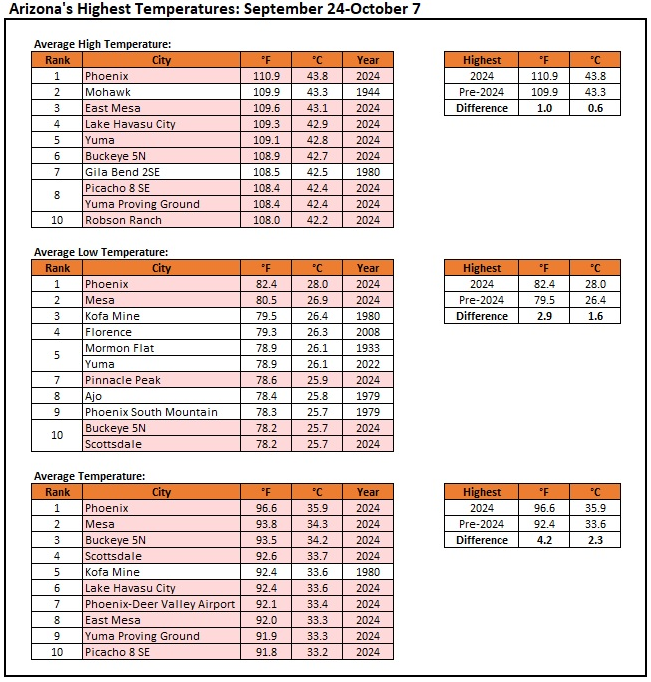
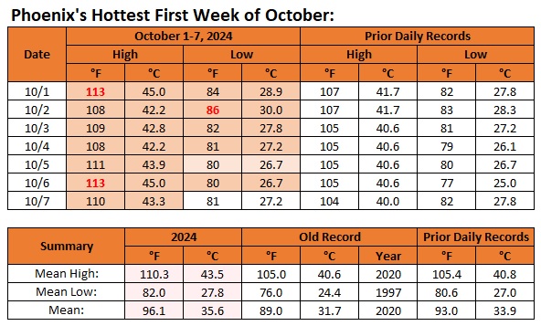
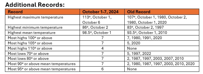
Here is how Arizona's record book was rewritten during the 14-day September 24-October 7, 2024 period:
-
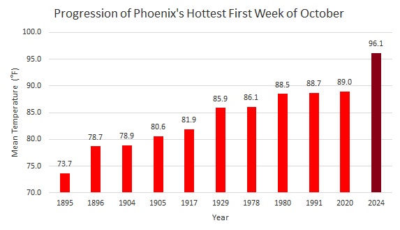
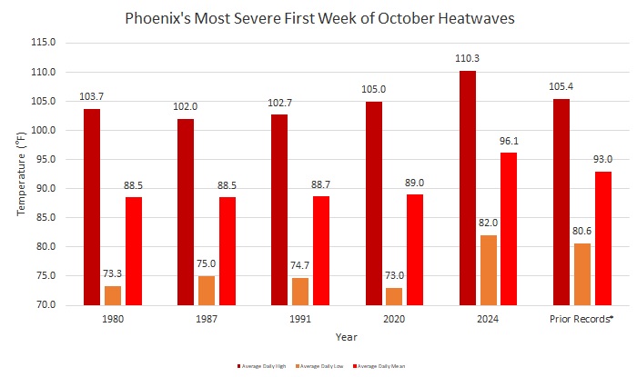
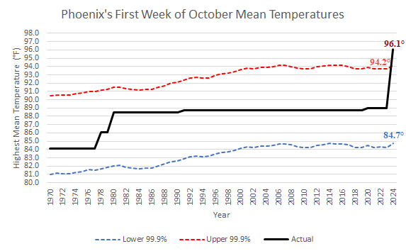
October 1-7, 2024 saw Phoenix demolish the record for its hottest first week of October on record. No prior October heatwave even begins to compare. Even a synthetic heatwave constructed of all October 1-7 pre-2024 record high maximum and minimum temperatures was smashed. Climate change played a leading role in driving the unprecedented heat, which included a 14-consecutive day stretch of record tying and record breaking high temperatures (September 24-October 7). According to Climate Central's Climate Shift Index, the heat in Phoenix and surrounding areas (including rural areas not impacted by the Urban Heat Island Effect) was made at least five times as likely due to climate change. Select Charts: The October 1-7, 2024 96.1° 7-day mean temperature was so extreme that it falls outside of what would statistically be expected using a 99.9% confidence interval based on 30-year moving average October 1-7 mean temperatures. The incredible late-season heat was widespread in the Southwest. Numerous records were broken, some by very large margins.

-
The region will see its coolest air so far this season this week. Tomorrow will be cooler and then a reinforcing shot of even chillier air will arrive on Wednesday. New York City could see its first temperature below 50° since May 13th on Thursday or Friday. On Wednesday evening, Hurricane Milton will make landfall on Florida's west coast. The storm, which grew into an extreme Category 5 hurricane with an 897 mb central pressure and maximum sustained winds of 180 mph, will likely make landfall as a Category 3 and perhaps Category 4 hurricane. It will bring a devastating storm surge inland. There remains a risk that the heavily populated Tampa ara could face some of the hurricane's worst impacts. The later guidance will lead to a more precise picture. In the Southwest and parts of California, near record and record heat continued. Phoenix registered its fourth 110° high temperature this month. San Jose experienced its longest stretch of 95° or above temperatures on record. Death Valley, Palm Springs, and Phoenix all exceeded the national record for average high temperature during the 14-day September 24-October 7 period. The extreme heat will fade over the next few days. The NAO fell to a preliminary -2.751 on September 24th (all-time September record: -2.371, September 12, 1971). That was the 9th lowest value on record. La Niña winters following September cases where the NAO fell to -1.900 or below featured a predominantly positive NAO. The most recent such winters were 2016-2017 and 2022-2023. The mean temperatures for those winters in New York City were 39.3° and 41.0° respectively. The 1991-2020 normal value is 36.2°. A warmer outcome is favored by the September run of the C3S multi-model forecast for Winter 2024-2025. Weekly ENSO data remains unavailable due to the dirsuptive impact Hurricane Helene's floods had on NCEI in Asheville. The ENSO Region 1+2 anomaly was +0.2°C and the Region 3.4 anomaly was -0.5°C for the week centered around September 18. For the past six weeks, the ENSO Region 1+2 anomaly has averaged -0.20°C and the ENSO Region 3.4 anomaly has averaged -0.18°C. Neutral ENSO conditions will likely evolve into a La Niña event during the fall. The SOI was +15.79 today. The preliminary Arctic Oscillation (AO) was -2.445 today. Based on sensitivity analysis applied to the latest guidance, there is an implied 58% probability that New York City will have a warmer than normal October (1991-2020 normal). October will likely finish with a mean temperature near 58.5° (0.6° above normal).
-
Occasional Thoughts on Climate Change
donsutherland1 replied to donsutherland1's topic in Climate Change
Hurricane Milton is the latest tropical cyclone to undergo rapid intensification (RI). It has intensified at among the fastest rates on record. In response, as happened with Hurricane Helene, the climate change denial community will all but certainly try to dismiss the climate change link through a deluge of logical fallacies and disinformation. Climate denial arguments could suggest or imply that the occurrence of past hurricanes precludes a climate link, past rapid intensification cases preclude a climate link, a direct hit in the Tampa Bay area in 1848 means that climate change could not have contributed to a similar outcome, tropical cyclones are synoptic events therefore climate change or CO2 isn't involved, or that there is no trend in RI cases (using "cherry-picked" timeframes), etc. One should ignore the Social Media noise toward that end and obtain their information from credible sources. Those making the arguments have motivated bias, are uninformed, are unable to synthesize multiple data points to reach informed judgments (how climate change can impact tropical cyclones through marine heatwaves, greater atmospheric moisture, etc). Findings: As long-term variations in RI are potentially influenced by large-scale circulation and global ocean conditions, the effects of internal climate variability and global ocean warming were investigated. The internal climate variability was assessed using climate indices such as El Niño–Southern Oscillation (ENSO) and Pacific Decadal Oscillation (PDO), while the effects of global warming were estimated using the trend of global mean sea surface temperature (SST) between 60 °S and 75 °N. The impacts of these metrics were eliminated by linearly regressing the time series of the RI onto the climate indices. Marginal differences were found when the Niño3 index was removed, and the amplitude of RI landward variation... maintained at 0.4 ± 0.2/decade/1000 km. This indicates that the impacts of ENSO on these long-term landward variations are negligible, although it may have a substantial role in inter-annual variability50; hence, further exploration is required. Meanwhile, the PDO or global mean SST alone moderately influenced RI. With the removal of their impacts, the landward variation rates decreased slightly to 0.3/decade/000 km for PDO and 0.2/decade/1000 km for SST... However, it should be mentioned that with the impacts of global SST removed, the increasing rate of RI events declined to ~0/decade per decade, particularly in regions that were beyond 600 km from the coast. This suggests that global warming is a key driver of increases in RI events... https://www.nature.com/articles/s41467-023-40605-2 ...our conclusions indicate that anthropogenically-forced climate change has already contributed to the observed, detectable increase in the proportion of rapidly intensifying hurricanes... https://www.nature.com/articles/s41467-022-34321-6#change-history TCs are amongst costliest and most dangerous natural hazards to impact the U.S., and the hazard they present has grown as storms have become more extreme due to anthropogenic warming. The rapid intensification of TCs in a warmer climate is particularly concerning, given that such events can be difficult to forecast and predict, leading to potentially escalated damages as well as difficulties when communicating the approaching hazard to coastal residents who may be in the TC’s path... These peak TC intensification rates have increased alongside anthropogenically-driven increases in SSTs, which have been rising at an increased rate in recent decades. Sufficiently warm SSTs serve as a vital energy source for intensifying TCs, and simultaneous increases in both extreme SSTs and maximum TC intensification rates suggests that human-caused warming has already had a measurable impact on the speed with which TCs strengthen. https://www.nature.com/articles/s41598-023-42669-y -
Tomorrow will be variably cloudy with perhaps some morning showers or even a thundershower as a strong cold front crosses the region. Following the frontal passage, the region will see its coolest air so far this season. New York City could see its first temperature below 50° since May 13th after midweek. During the middle of the week, Hurricane Milton will make landfall on Florida's west coast. The storm will likely make landfall as a Category 3 and perhaps Category 4 hurricane. It will bring a devastating storm surge inland. There remains a risk that Tampa could face some of the hurricane's worst impacts even as the guidance has shifted somewhat southward. The later guidance will lead to a more precise picture. In the Southwest and parts of California, near record and record heat continued. Phoenix reached 113°, which smashed the daily record by 8° and tied the monthly record set on October 1st. Since September 25th, Phoenix has had 6 days with highs of 113° or above. In its full-year climate record that goes back to 1896, 98 years (76% of the record) had fewer than 6 such days. The most recent such year was 2014 (3 days). The region has never seen a late-season heatwave like the current one. The extreme heat will fade toward midweek. The NAO fell to a preliminary -2.751 on September 24th (all-time September record: -2.371, September 12, 1971). That was the 9th lowest value on record. La Niña winters following September cases where the NAO fell to -1.900 or below featured a predominantly positive NAO. The most recent such winters were 2016-2017 and 2022-2023. The mean temperatures for those winters in New York City were 39.3° and 41.0° respectively. The 1991-2020 normal value is 36.2°. A warmer outcome is favored by the September run of the C3S multi-model forecast for Winter 2024-2025. The ENSO Region 1+2 anomaly was +0.2°C and the Region 3.4 anomaly was -0.5°C for the week centered around September 18. For the past six weeks, the ENSO Region 1+2 anomaly has averaged -0.20°C and the ENSO Region 3.4 anomaly has averaged -0.18°C. Neutral ENSO conditions will likely evolve into a La Niña event during the fall. The SOI was +10.31 today. The preliminary Arctic Oscillation (AO) was -1.970 today.
-
Yes. I used the whole January-March period.
-
Since 1950, there were 12 La Niña events that had warmer than normal Decembers in the northern Mid-Atlantic region. Two were colder than normal with near normal to above normal snowfall. Two were also warmer than normal with above normal snowfall. Six were warmer to much warmer than normal with below to much below normal snowfall. January-March 2009 and January-March 1974 had the best combination of cold and snow following a warm December.
-
It will turn somewhat cooler tomorrow. Monday could see some showers as a strong cold front crosses the region. In its wake, the region will see its coolest air so far this season. New York City could see its first temperature below 50° since May 13th during the second half of next week. During the middle of the week, what will likely become major Hurricane Milton will likely make landfall on Florida's west coast. The storm will bring a devastating storm surge inland. There is a risk that Tampa could face some of the hurricane's worst impacts, but later guidance will lead to a more precise picture. In the Southwest and parts of California, near record and record heat continued. Phoenix reached 111°. Palm Springs reached 115°. That was the highest temperature on record so late in the season in the United States. The extreme heat will persist into early next week before it fades. The NAO fell to a preliminary -2.751 on September 24th (all-time September record: -2.371, September 12, 1971). That was the 9th lowest value on record. La Niña winters following September cases where the NAO fell to -1.900 or below featured a predominantly positive NAO. The most recent such winters were 2016-2017 and 2022-2023. The mean temperatures for those winters in New York City were 39.3° and 41.0° respectively. The 1991-2020 normal value is 36.2°. A warmer outcome is favored by the September run of the C3S multi-model forecast for Winter 2024-2025. The ENSO Region 1+2 anomaly was +0.2°C and the Region 3.4 anomaly was -0.5°C for the week centered around September 18. For the past six weeks, the ENSO Region 1+2 anomaly has averaged -0.20°C and the ENSO Region 3.4 anomaly has averaged -0.18°C. Neutral ENSO conditions will likely evolve into a La Niña event during the fall. The SOI was +2.19 today. The preliminary Arctic Oscillation (AO) was -1.569 today.
-
I agree. It's difficult to have a cold winter down here when Alaska is also cold.
-
But not as warm as the past two winters if these numbers verify.
-
When it gets closer to the season, I'll post month-by-month estimates (if I recall correctly, the skill related to the 3-month average is better than that for month-by-month forecasts from this timeframe). The key takeaway right now is that the Euro seasonal is warm, but not as warm as the last two winters. All things being equal, there should be some better opportunities for snowfall than one has seen in parts of the East during the past two winters. I still think the Great Lakes region will have normal to somewhat above normal snowfall. For those who are interested, February is forecast to be only slightly above normal in the Mid-Atlantic Region (southern Great Lakes Region) and near normal in New England (much of the Great Lakes Region).
-
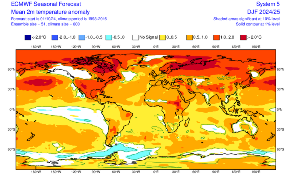
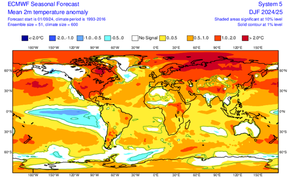
New ECMWF Winter 2024-2025 Forecast:
-
ECMWF Winter Forecast: October run: September run: