

frd
-
Posts
6,931 -
Joined
-
Last visited
Content Type
Profiles
Blogs
Forums
American Weather
Media Demo
Store
Gallery
Everything posted by frd
-
A change is on the horizon for mid November according to HM and Ben
-
I love to hear your thoughts Mr Douglass, but alas you live in the promise land .
-
Continued warmth ahead .....for mid October Little by little is doesn't really matter whether the Pac is on our side or not. Blocking in the AO and NAO domains doesn't gaurantee or foster snow any longer to the lower lattititudes, which includes us. In a general warming base state you will achieve less cold air intrusions with less severity when you start with less available cold air, but also a not so conducive cryosphere to transport that cold air to lower lattitudes. Telleconnections do not work as they did before. Analog years do not work as they did before. Data shows that less and less snow is falling in our area and in areas to our SW and South. Get use to pathetic snowfall and warmth year around.
.thumb.jpg.a1f3144454d025f779d4644c9e4d77e2.jpg)
-
Snow is being talked about out West, and not only the mountain areas. Meanwhile the typical October robust WAR holds serve, while warm Atlantic ocean temps remain over wide areas of the basin.
-
In this backdrop we have post-tropical Sam and a unusual path.
.thumb.gif.443c9b3950487d62fb0a89a25c3cdae4.gif)
-
Excellent trend and no funny business so far with the QBO.
-
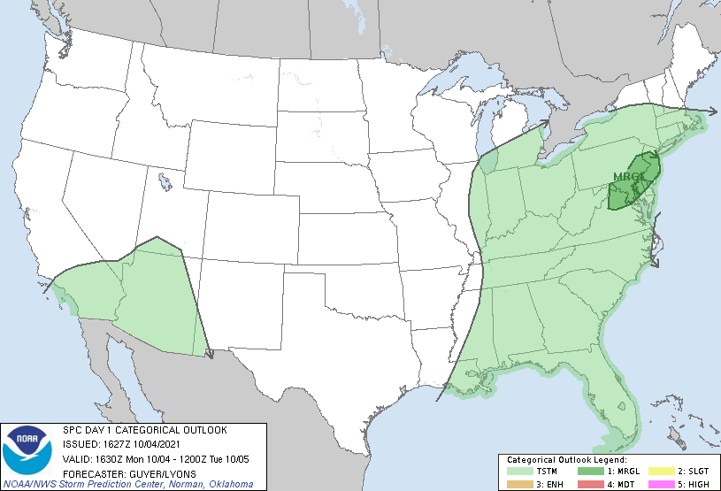
SPC AC 041627 Day 1 Convective Outlook NWS Storm Prediction Center Norman OK 1127 AM CDT Mon Oct 04 2021 Valid 041630Z - 051200Z ...THERE IS A MARGINAL RISK OF SEVERE THUNDERSTORMS ACROSS THE MID-ATLANTIC/DELMARVA... ...SUMMARY... Strong to locally severe thunderstorms may occur across the Mid-Atlantic States/Delmarva this afternoon and evening. ...Mid-Atlantic States/Delmarva... It appears that some strong to marginally severe storms, potentially capable of localized wind damage, may occur this afternoon and evening. The region will be cyclonically influenced by the weak upper low centered over the Ohio Valley/Lower Great Lakes and its peripheral mid-level cool pocket and modestly strong (20-25 kt) southwesterly mid-level winds. Latest visible satellite trends reflect steady clearing especially near/east of the Appalachians spine across Virginia and Maryland, but also across the Delmarva/southern New Jersey. MLCAPE values should reach/locally exceed 1000 J/kg, with weak convergence/differential heating along the higher terrain/mountains (and front across PA/NJ) expected to influence thunderstorm development this afternoon. A steepening of low-level lapse rates and a moist environment could support some locally strong to severe storms.
-
Growing support for a deeper dive with the Arctic oscillation for late October. If it happens it will support the idea that November would feature a weaker than normal polar vortex.
-
As I mentioned above the Euro has been off its game for quite some time. Can you imagine if it was Winter and that was ❄️ never trust the Euro! ( Unless there is multi model agreement).
-
Seems the Euro still doesn't get things correct at range.
.gif.7a03c6ac04904c3af880b6dc9ab05f86.gif)
-
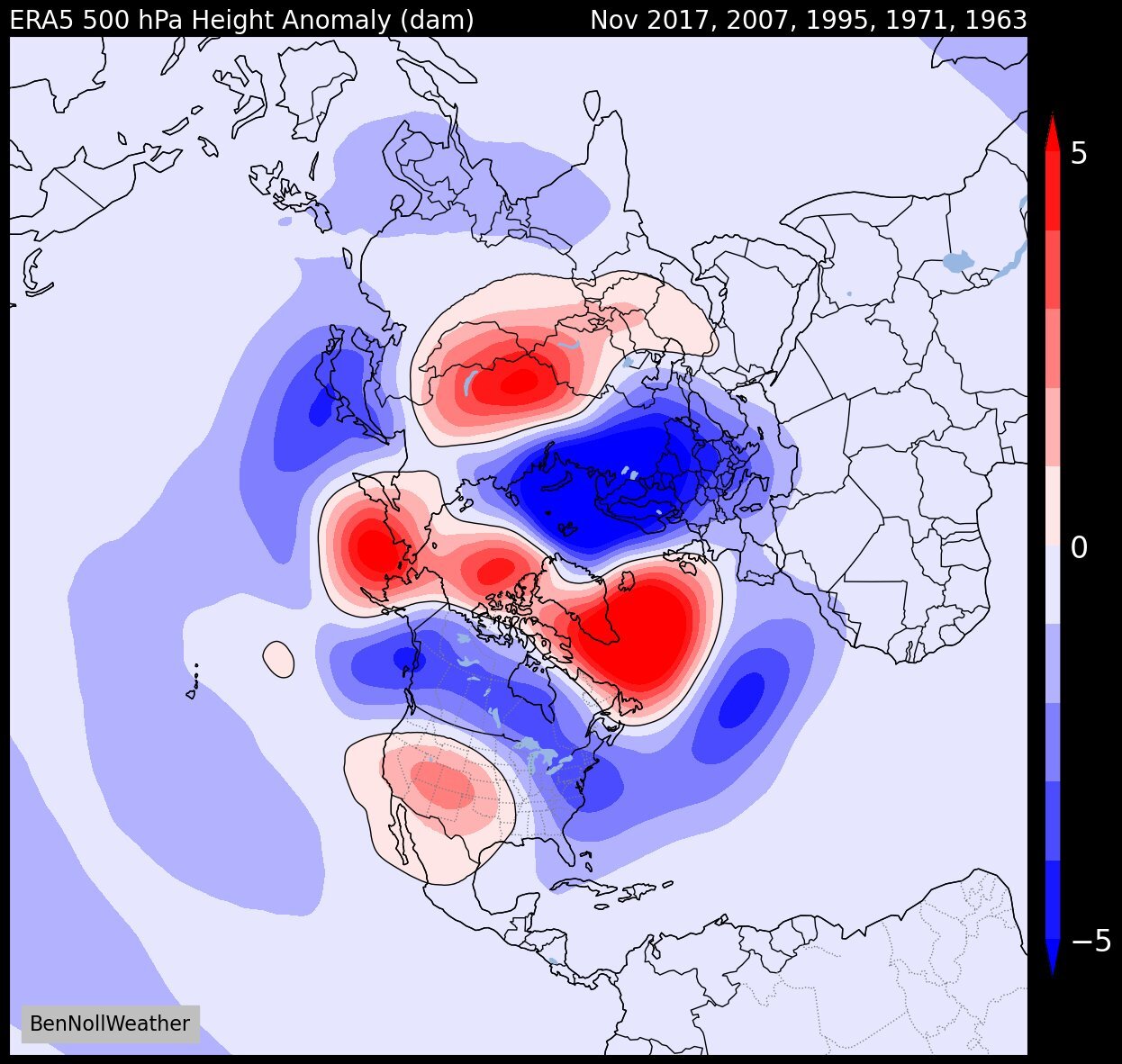
Some of the warmest Octobers on record have produced this in the following Novembers.

-
Went to the dog park, just got back. Feels like August out there Yuck !
-
The warmer this October ends the higher the odds of a colder Novemember into and early to mid December . So far things look to line up very warm in the NE
-
Yes, but some here say don't try to forecast past day 10. Because the forecast will be wrong. Hard to deny October warmth. ( and October humidity as well )
-
Another October cementing it's reputation as a rapidly warming month. No denying the trend. Some thought it would turn out cooler than normal, that's not going to happen. And yes, I am saying that knowing it's only the 3 rd of the month.
-
Possibly central Pac based La Nina setting up during the boreal winter. There is support for that outcome.
-
Pull the rubberband
-
Colder
-
QBO check
-
Well your seed may wash away. The trend is wetter !
.gif.b0704765cca4b6c71527b9436e105a03.gif)
-
At least we are not off to the races
.thumb.gif.8b110f400ce1ea414a2851f5f03597d1.gif)
-
Nothing like a 60 foot wave.
-
Wow !
-
End of next week looks depressing, unless you are reseeding your lawn. .

.jpg.fdfa697769fe0af2e487c9c6902e6276.jpg)

.gif.ca0739df97e0c44e930f6a0e03a66719.gif)

.gif.c8bcdf01d72c5fd91ea101ea41f2aac9.gif)