

frd
-
Posts
6,931 -
Joined
-
Last visited
Content Type
Profiles
Blogs
Forums
American Weather
Media Demo
Store
Gallery
Everything posted by frd
-
Very interesting descending QBO numbers so far. Some analogs related to this would lead to a cold, and potentially stormy December in the East.
-
Latest data supports a potentially colder December. Good luck with your forecast. A cold holiday period would be great, some snow would make it even better !
-
Looking interesting
-
Seasonal versus the drivers.
-
Heavy frost and freeze here. Growing season is over. This is actually earlier than last year by several weeks.
-
What a useless model. Flips every day. Best skill seems to be the last 6 days of the month for the month ahead.
-
PV getting stronger now before a possible weakening later in the month.
-
Snow cover, both in Eurasian and North America, look pathetic. If you thought last winter had a rough start this looks even worse. As HM mentioned things are looking ZZZ..... in the snow cover department.
-
Recent trends are starting to back up the idea that the PV starts to weaken again by mid to late month along with lessening zonal winds and possibly a change in the NAM state.
.thumb.gif.5922f5dc1ac6d9e6711b88d99bb43036.gif)
-
End of the month cool down possible after the mid-month warmth. Actually in the end there is some evidence that this November's HDDs may end up closer to normal, however that remains to be seen.
-
If you are counting on our source regions to help deliver cold into our area this month the odds look very poor. Many record highs in areas that should be much, much colder. Same issues as last year, and only getting worse. Snow cover looks pathetic as well.
-
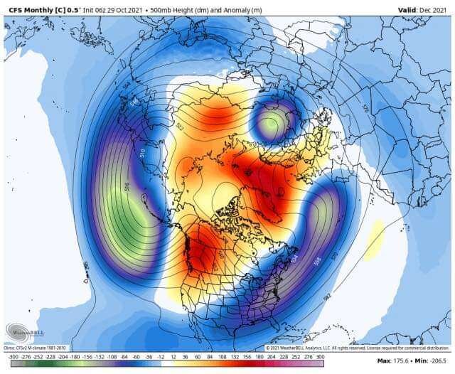
Here is the entire month of December based off the early morning run today. Front loaded winter? Seems to be two camps on that notion.
-
PV strengthens back after this initial weakening. Moderation in temps during mid November is possible. Later in the month more significant pattern change may develop. I think the odds of a colder December versus November may be more likely given the data currently.
-
The focus of that post are the warm SSTs. So you think October and September have been below average ? You are saying the last few years Fall has made an early arrival to the Coastal Plain? Forget about the cold front aspect. Focus on the general warmth around the periphery of the robust WAR supported by above avergae Western Atlantic SSTs. There are many reporting stations along the East Coast that have recently recorded record highs, as well as record high minimum temps, the last few years in September and October due to this effect.
-
As a continuation from above it would be beneficial to mention a recent post from bluewave. Here the focus are the warm SSTs and the impact they have on the WAR. It is well known that in recent Falls along the East Coast above average Atlantic SSTs have contributed to warmer than normal weather lasting well into October, if not later. Keep in mind that cold fronts may have a difficult time initially moving East with the coldest anomalies to the coastal plain. from bluewave: It looks like the models are continuing to struggle with the influence of the record SSTs to our east. So the WAR puts up more resistance to the cold front to our west. This has been a common theme in recent years. New run Old run
-
Overnight Euro trended much colder in the center of the US in the medium range . This looks to move East in time. Growing season will end for many areas out West who have not experienced a freeze yet.
-
Nina's can be front loaded. Pac jet retraction combined with weaker early season PV together give some credence to the weeklies portrayal.
-
It would appear this will take on a hybrid structure and deepen rapidly along the offshore baroclinic zone.
-
A good sign moving forward despite knowing we are battling a Nina in a warmer background state. Coastal action is welcome sign.
-
Yep, get ready for all the upcoming disappointments.
-
Today's Euro much less rainfall in our area. NE gets destroyed, nothing new.
-
Same here, also the AFD from Mount Holly a few days back focused on the incredibly warm ocean temps off the Mid Atlantic coastline. Same pattern the last four years. Warm ocean temps reinforcing the WAR. Was 70 degrees in the surf the week before last in North Wildwood, NJ.
-
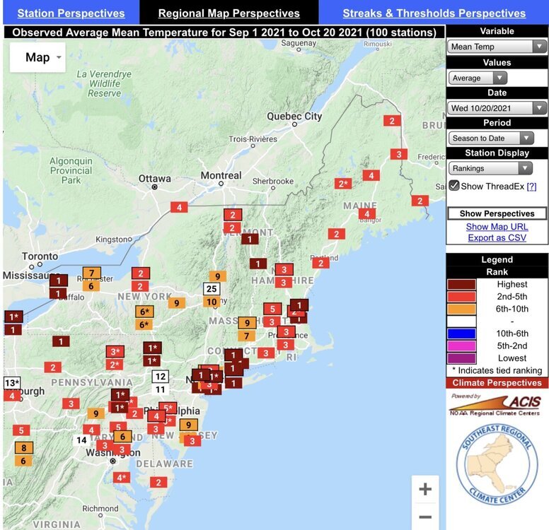
from bluewave Our region in top 4 warmest Fall temps through the 20 th of this month. Some areas warmest ever. The warming is undeniabe.

.gif.b48857bb864c9004bf9ea15010a425ba.gif)


