frd
-
Posts
7,161 -
Joined
-
Last visited
Content Type
Profiles
Blogs
Forums
American Weather
Media Demo
Store
Gallery
Everything posted by frd
-
Eric Fisher @ericfisher Looking like a front-loaded winter that will get off to a fast (cold) start
.thumb.jpeg.4bbc22c83ad554893514ecc3eeec87b5.jpeg)
-
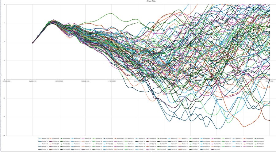
Allan Huffman @RaleighWx Some chatter in the long range about a SSWE. Here was yesterdays 00z EC46 10mb U forecast. Lots of squiggly lines but in looking at the raw data, 45 of the 100 EC46 members show at least 1 day with a -U (reversal) between now and 12/19with 12/1 the day with the most members with a negative value. If a SSWE occurs, it CAN increase the risk for high latitude blocking (-AO) and increased risk for discharge of arctic air into the mid latitudes, usually 1-2 weeks after the reversal. Just an interesting item to monitor.
-
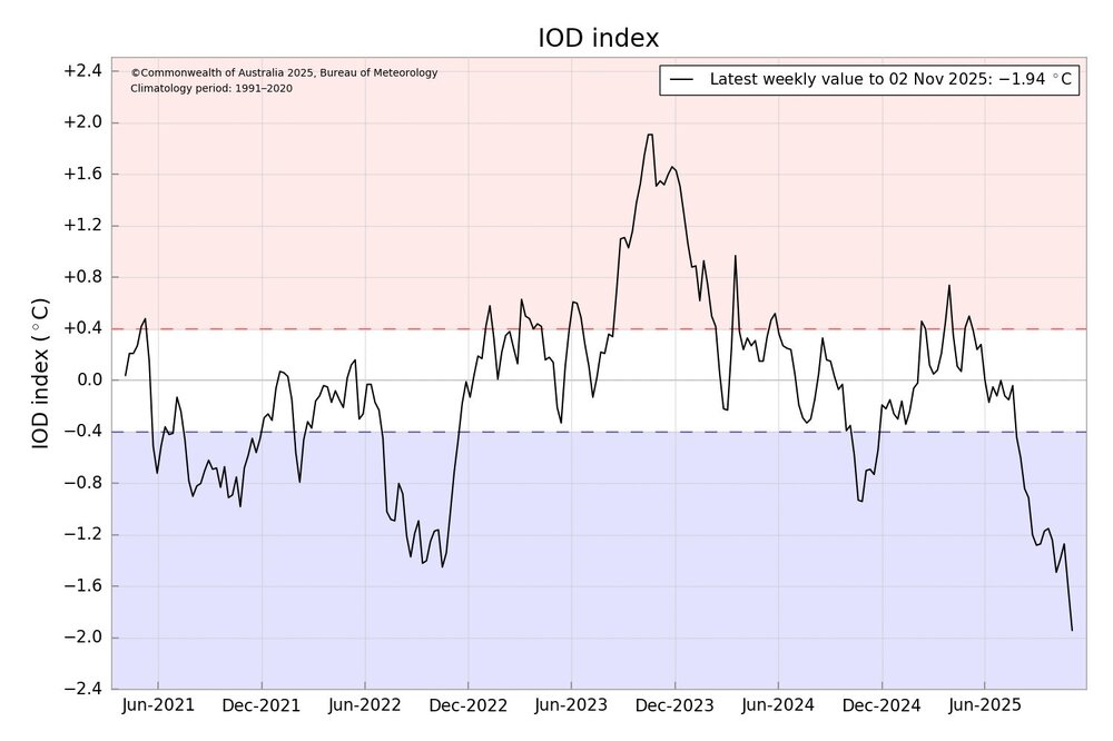
Uncharted territory here with this new record negative IOD.
-
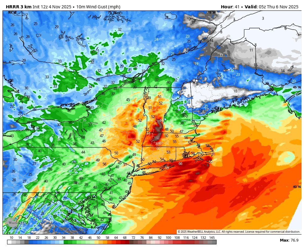
Interesting wind potential, but much higher well NE of the area.

-
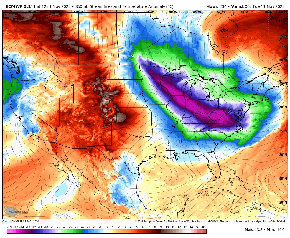
First cold airmass arrives near November 10th and the 11 th. Could be a rather intense cold frontal passage. Warmth prior to this, with next Saturday having the potential to hit 66 to 67 degrees. This Wednesday highs near 63 to 65.

-
Wasn't this the March that featured the intense Greenland block that retrograded and caused extreme cold and snow ( as you mentioned.) I recall many school closings that March.
-
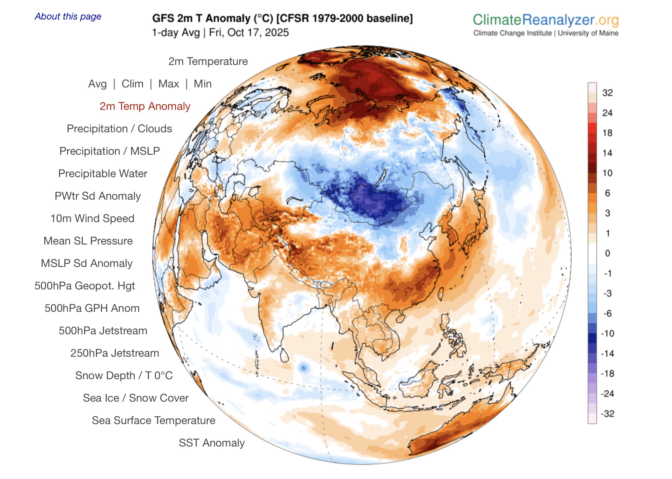
Yes, it is early. Ryan Maue reposted Thierry Goose @ThierryGooseBC · 15h After Russia yesterday, Mongolia has just recorded its first -30°C of the season and this is exceptionally low for this time of year! -30.9°C Khatgal 3rd lowest October temperature since records began in 1963 (record: -33.0°C in 1976)! -30.2°C Tsetsen-Uul
-
Extreme cold for this time of year in Siberia. Yesterday it broke records.

-
Trends continue with a reduction in precip. No surprise here, as the main rain area is well North of the forum.
-
I still have not done the overseeding yet. Keep putting it off due to heat and now if there is a wash out that would be bad. Its a gamble as to when the first frost hits. Normal time is late October, but hopefully with these everlasting Falls maybe it waits till the third week of November. Hard to say. Believe you need 45 days post over seed for seeds to live.
-
https://www.wpc.ncep.noaa.gov/discussions/hpcdiscussions.php?disc=pmdepd
.gif.829f5a485203ac14568e069f8839114d.gif)
-
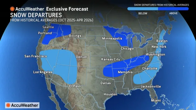
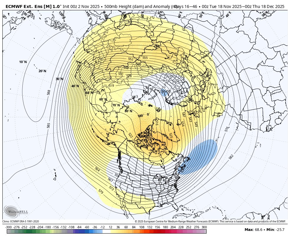
Seasonal ECMWF guidance predicts a prominent Alaskan ridge this winter, which would allow the polar jet stream to deliver cold air to the northern United States. However, a relatively strong eastern ridge is shown — stronger than last winter — which could shield the East Coast. https://x.com/BenNollWeather/status/1975561499180736754
-
Mount Holly's forecast for this Friday through Monday has no mention of rain for my area. Yesterday it had a 30 % chance of showers. Seems the probability of significant rainfall is decreasing although the range of outcomes is mentioned in the morning AFD. Guidance still differs in the evolution of the coastal system from Saturday night into early next week, but we are beginning to see a range of potential outcomes for our area. A weaker and/or farther south solution with the surface low would translate to lesser impacts and lower chances of showers for our region. A stronger and/or farther north placement of the surface low pressure would translate to greater and potentially more significant impacts to our area, especially along and near the coast. This may include potential for coastal flooding, beach erosion, and strong winds near the coast and possibly inland across the coastal plain. Again, a lot of uncertainty with this system, but it bears monitoring closely as it could pack a punch if it draws close enough to our area.
-
Or, even go further South depending on the power and position of the block, just too early to know.
-
-
Mostly cloudy now, despite the forecast of mostly sunny.
-
Very lucky here presently, with .36 inch so far.
-
That must be mostly Siberia I would think. But, still good.
-
The stadium effect is incredible. Looks like a West Pac super Typhoon.
-
2025 Mid-Atlantic Garden, Lawn, and Other Green Stuff Thread
frd replied to mattie g's topic in Mid Atlantic
Starting my overseed project this Weds to coincide with the lower air temps, a bit late, but hopefully still Ok . i am fighting dollar spot and leaf spot so I am not even using nitrogen yet but using a couple soil amendments.
.jpeg.8a6c72a6d9e44fce958cccf9f1ab0f2d.jpeg)


.jpeg.a811db0aebb5f553cec962f592abe9d7.jpeg)