frd
-
Posts
7,161 -
Joined
-
Last visited
Content Type
Profiles
Blogs
Forums
American Weather
Media Demo
Store
Gallery
Everything posted by frd
-
A harbinger of the upcoming winter.
-
74/45 at 2:00 PM 8/30/25.......... is this the Matrix ?
-
Working outside and its a joy! The breeze and cool air is Zen-like .
-
Dew point quickly dropping here 76/50
-
Congrats ! Lawn disease seems to have reversed here.
-
Some cells near Elkton, MD. Grid forecast only 20 % chance of rain. Maybe this area will simply pulse down.
-
Dew point here at 48, I love it outside doing garden and yard work, feels awesome ! Meanwhile, way up North they are setting records for all-time warmth for this time of year.
-
I wonder if the weather pattern in the western us and Eastern Pacific will lead to an increasing PDO
-
Dew point 50 ! Exceptional
-
73/68 currently here. Dew point up a little this AM., can feel the difference, but cooler weather is on the way.
-
2025 Mid-Atlantic Garden, Lawn, and Other Green Stuff Thread
frd replied to mattie g's topic in Mid Atlantic
My lawn was green, but leaf spot and brown patch came to visit. I heard from many lawn pros it is rampant in the NE this summer from excessive cloud cover, warm nights, excessive rain and high dew points. A lot of triggers for disease pressure and various lawn diseases. -
55/58 here. Best news is I see the sun. Glorious!
-
2025 Mid-Atlantic Garden, Lawn, and Other Green Stuff Thread
frd replied to mattie g's topic in Mid Atlantic
Is it brown turkey fig tree ? -
Wow, those waves are huge. Bigger than what I observed in Dewey. Maybe because of the more gradual drop off at the the Wildwood's beaches , versus the crazy drop off at Dewey.
-
We are approaching high tide at Dewey Beach and despite the storm moving away, the waves to me are the worst they've been to this point. Huge breakers rolling in and have reached the dune and walkways.
-
Yes, I noticed that on the beach with blowing sand. Please take a video and post it if you can.
-
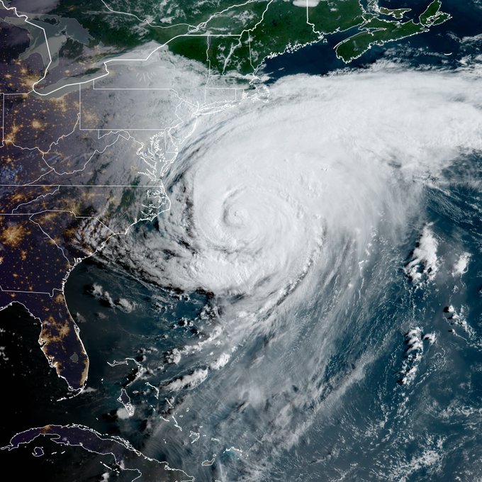
Tim Kent • Today https://www.surfline.com/surf-report/rambler-road/5842041f4e65fad6a7708b60?referral=msw&view=table https://northwildwood.com/north-wildwood-surf-cams/ Solid surf approaching 2x overhead+. Winds are unfavorable locally and most breaks are overloaded. Solid well overhead surf this morning with onshore NE winds and trashed conditions. Only doable at the sheltered/novelty spots. The big issue is that it looks like we'll see strong onshore NE winds throughout the day, meaning conditions will be choppy and very challenging. A expert only day anyway, and most breaks won't be worth the risk/reward. UPDATE: OBX, NJ See Erin’s Windy Side https://forecast.weather.gov/product.php?site=PHI&issuedby=PHI&product=AFD&format=CI&version=1&glossary=1&highlight=off MARINE... Tropical Storm Warnings are in effect for the waters offshore Manasquan Inlet to Fenwick Island through tonight with a Gale Warning in effect for the waters offshore Sandy Hook to Manasquan Inlet through tonight. For the lower Delaware Bay, a Gale Warning is in effect through midnight tonight. For the upper Delaware Bay, a Small Craft Advisory is in effect through tonight. Northeast winds continue to steadily increase today as Hurricane Erin approaches with sustained winds between 25-35 kt expected. Wind gusts upwards of 40-45 kt are expected on the Atlantic coastal waters with gusts upwards of 30-40 kt expected on the Delaware Bay before gradually diminishing overnight. Occasional showers possible across all waters which may cause locally higher gusts. Seas of 8-12 feet this morning will steadily build up to 12-17 feet this afternoon before gradually beginning to abate tonight for the Atlantic coastal waters. Rough and choppy waters are expected on the Delaware Bay.
-
I had a house on 14th Street North. Wildwood would go down there when I was 5 years old. It was always so much fun and still do now but don't have a home there any longer. I can imagine the areas that flood are probably in pretty bad shape right now thinking West Wildwood and that bridge area and back Bay areas. The video camera at 15th and surf avenue at the lifeguard station shows a pretty wild situation with huge seas, very choppy conditions and high winds. Was a crummy week at Dewey but looking forward to some more day trips in September to the beach as the ocean remains warm and there should be some days with offshore winds for good surfing.
-
East of Fenwick , seas up last 90 minutes https://www.surfline.com/buoy-report/delaware-bay-26-nm-southeast-of-cape-may-nj-buoy-44009/2de908f0-cecc-11eb-890b-024238d3b313 Significant Height 12.5FT Dominant Period 8s Mean Direction ENE69° Wave Energy 2962kJ Wind 29KTSNNE 39kts gust Temperature 72°F air Air 75 F water
-
Rather impressive.
-
Oh my Current Surf Conditions Local time:11:42am, EDT (UTC-4) Condition Rating Forecaster·39 mins ago POOR Surf Height 6-10FT Observed Head to 2x overhead https://northwildwood.com/north-wildwood-surf-cams/
-
First time in while when looking at https://www.greencastonline.com/tools/soil-moisture my current soil moisture is above 5 year and 10 year averages, while my current soil temp is below 5 year and 10 year averages. I believe to overseed a cool season lawn you want a 5 day average soil temp of 70 degrees or lower. Still waiting until Sept to do any lawn overseeding projects, but at least the medium trend is positive for lawn health in areas of the forum where rain has fallen.